High Altitude Pseudo Satellite (HAPS)
12-02-2024
12:03 AM
1 min read

What’s in Today’s Article?
- Why in the News?
- About High Altitude Pseudo Satellite (HAPS)
- Benefits/Advantages of HAPS
- Significance w.r.t. India
- News Summary

Why in the News?
- CSIR-National Aerospace Laboratories (NAL) has successfully tested an unmanned aerial vehicle, called High Altitude Pseudo Satellite (HAPS) at Challakere, Karnataka, earlier this month.
About High Altitude Pseudo Satellite (HAPS)
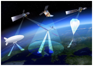
- Since the 1990s, a number of initiatives have been launched worldwide to explore the potential applications of High Altitude Pseudo Satellites, also called High Altitude Platform Stations (HAPS).
- HAPS are aircraft positioned above 20 km altitude, in the stratosphere, for very-long-duration flights counted in months and even years.
- These unmanned aircraft may be airplanes, airships or balloons.
Benefits/Advantages of HAPS
- These solar-powered vehicles have been designed to plug the missing link between unmanned aerial vehicles (UAVs) flying in lower altitudes and conventional satellites in space.
- The use of HAPS is considered for a variety of applications such as:
- telecommunications,
- emergency/public safety communications,
- intelligent transportation systems,
- maritime surveillance,
- environmental monitoring,
- land border control applications, etc.
- Compared to ground based communication networks, HAPS can cover larger areas with less interference.
- They could also help ease data transfer when used as an intermediate conduit between a satellite and ground based telecom networks.
- Unlike regular satellites that are expensive to build and launch, HAPS cost far less and are easier to launch.
Significance w.r.t. India
- In India, Hindustan Aeronautics Limited (HAL) in 2022 had announced that it is developing a “futuristic” high altitude pseudo satellite in collaboration with a start-up company.
- With a long and complex land border of about 15,000 km and a coastline of about 7,500 km, safeguarding the borders is crucial for India and necessitates varied solutions.
- Hovering at the edge of the Earth’s atmosphere, HAPS can provide services towards efficient border patrolling, tracking movements deep into the enemy territory or in the deep seas with their sharp focus on one area.
- Equipped with high-definition optical and infra-red cameras, state-of-the-art sensors, these aerial platforms are suitable for round-the-clock missions, border patrolling, target tracking, maritime surveillance and navigation, and even missile detection.
- China’s state-owned aerospace and defense conglomerate, Aviation Industry Corporation of China (AVIC), has been working on varied HAPS platforms for surveillance purposes.
- In 2018, it successfully tested its solar-powered Morning Star drone which can reportedly stay airborne for months.
News Summary
- National Aerospace Laboratories (NAL) has successfully tested an unmanned aerial vehicle, called High Altitude Pseudo Satellite (HAPS) at Challakere, Karnataka, earlier this month.
- The 5-metre-long system, with a wingspan of 11 metres and weighing 23 kg, rose to about 3 km and stayed put for about eight hours.
- A series of tests have been planned and they are expected to culminate in a full-bodied craft – with a wingspan of 30m (nearly as much as a Boeing 737) – by 2027.
- It will be able to rise to 23 km and stay airborne for at least 90 days.
- NAL aims to design and build the HAPS’ propellers, battery management system, carbon-composite airframe, flight-control system, and the high-powered electric motors that can withstand extreme temperature ranges.
- Last month, in an unrelated project, a Bengaluru-based private company carried out the first test-flight of a solar-powered, long-endurance drone that flew for 21 hours.
Q1) What is the definition of Stratosphere?
Stratosphere is the layer of the earth’s atmosphere between about 10 and 50 kilometres above the surface of the earth.
Q2) What do you mean by Escape Velocity?
The minimum velocity with which an object can escape the gravitational pull of the planet is called Escape velocity. In the case of earth, escape velocity is the minimum velocity required by a body to be projected to overcome the gravitational pull of the earth.
Source: CSIR NAL flies test-drone that can double up as ‘pseudo satellite’ | Indian Express
