Sunrise Industry
23-04-2025
06:37 AM

Sunrise Industry Latest News
Finance Minister Nirmala Sitharaman recently said India plans to increase the share of the manufacturing sector from 12% to 23% over the next two decades helped by sunrise sectors.

About Sunrise Industries
- Sunrise industry is a term frequently used for a sector that is developing and poised for rapid growth.
- Typically, such industries register high growth rates and have numerous start-ups and plenty of funding.
- Sunrise industry examples include the alternative energy industry highlighted in 2003 and 2007, the social media and cloud computing industries of 2011 and 2012, and blockchain industries established from 2013 to 2017.
- Other sunrise industries include information technology and clean energy.
- A sunrise industry often has a high degree of innovation, and its rapid emergence may threaten a competing industry sector already in decline.
- The competing industry sector is commonly referred to as a sunset industry.
- Life Cycle of a Sunrise Industry:
- As an industry grows and matures, it may pass from the sunrise phase to maturity and, finally, the sunset stage.
- The compact-disc industry is an example of such a transition.
- It was a sunrise industry in the 1990s when compact discs replaced vinyl records and cassette tapes, but the rapid adoption of digital media in the 21st century saw the industry move into the sunset phase.
Sunrise Industry FAQs
Q1. What does the term "sunrise industry" refer to?
Ans. A newly emerging and rapidly growing industry.
Q2. Why do sunrise industries attract investor interest?
Ans. They promise long-term growth and high returns.
Q3. Which factor most often drives the emergence of a sunrise industry?
Ans. Technological innovation
Source: TH
National Environmental Engineering Research Institute (NEERI)
23-04-2025
10:42 AM

National Environmental Engineering Research Institute Latest News
The Supreme Court recently directed the National Environmental Engineering Research Institute (NEERI) to conduct an assessment of the nearby glass industries that are impacting Taj Mahal at Agra in Uttar Pradesh.
About National Environmental Engineering Research Institute
- The CSIR-National Environmental Engineering Research Institute (CSIR-NEERI) is a research institute created and funded by the Government of India.
- It was established in Nagpur in 1958 with a focus on water supply, sewage disposal, communicable diseases, and to some extent, on industrial pollution and occupational diseases found commonly in post-independent India.
- NEERI is a pioneer laboratory in the field of environmental science and engineering and is a constituent laboratory of the Council of Scientific and Industrial Research (CSIR).
- The institute's primary mission is to conduct research and development activities related to various aspects of environmental management, pollution control, and sustainable development.
- NEERI falls under the Ministry of Science and Technology of the central government.
- Headquarters: Nagpur
- NEERI has five zonal laboratories at Chennai, Delhi, Hyderabad, Kolkata, and Mumbai.
- Organizational Expertise: Climate/Environment, Health, Lab or Field Testing, Monitoring and Evaluation, Policy Development, Research, Standards, Technology, and Fuel R&D.
National Environmental Engineering Research Institute FAQs
Q1. Where is the headquarters of CSIR-NEERI located?
Ans. Nagpur
Q2. Under which Indian government ministry does NEERI operate?
Ans. Ministry of Science and Technology
Q3. NEERI specializes in which of the following areas?
Ans. Environmental management and pollution control.
Source: TRIBUNE
Emissions Trading Scheme (ETS)
23-04-2025
12:48 PM

Emissions Trading Scheme (ETS) Latest News
The Surat Emissions Trading Scheme (ETS) is the world’s first market-based mechanism specifically designed to control particulate air pollution.
What is an Emissions Trading Scheme (ETS)?
- An Emissions Trading Scheme (ETS) is a regulatory tool that aims to reduce air pollution by introducing economic incentives.
- Under ETS, a cap is imposed on the total permissible emissions.
- Industries receive emission permits, which can be bought and sold, allowing companies to trade pollution rights.
- This system is also referred to as "cap-and-trade".
- Cleaner industries can sell their unused permits to polluting units, creating an economic incentive for pollution reduction.
Why is the Surat ETS Significant?
- The Surat Emissions Trading Scheme (ETS) launched in 2019, is the world’s first ETS focused on trading particulate pollution (not CO₂), and India’s first emissions market for any pollutant.
- It targeted 342 high-emitting industries, mainly in the textile sector, which used solid fuels like coal and lignite, and liquid fuels like diesel.
- The scheme was developed by the Gujarat Pollution Control Board (GPCB) in collaboration with J-PAL, EPIC, and Yale University.
Emissions Trading Scheme (ETS) FAQs
Q1. What is an Emissions Trading Scheme (ETS)?
Ans. An ETS is a market-based approach to control pollution by providing economic incentives to reduce emissions, commonly known as cap-and-trade systems.
Q2. How does an ETS work?
Ans. A government sets a cap on total emissions and issues permits, which industries can buy or sell based on their emission levels, promoting cost-effective reduction.
Q3. Which countries have implemented ETS successfully?
Ans. Notable examples include the European Union Emissions Trading System (EU ETS), South Korea, New Zealand, and some U.S. states like California.
Source: IE
Poas Volcano
23-04-2025
06:27 AM

Poas Volcano Latest News
The Poás volcano, one of Costa Rica's most popular tourist attractions, erupted recently.
About Poas Volcano
- Poás is one of Costa Rica's most active volcanoes.
- The volcano is located within the Poas Volcano National Park.
- It is a composite stratovolcano with an irregular complex form and a basal area of about 400 sq.km.
- It rises to 2,708 metres above sea level.
- It has been formed from adjoining eruptive centres with large collapse craters.
- Its main crater is about 1.5 km wide and 300 meters deep—one of the largest active craters in the world.
- Since 1989, it has markedly increased the emission of gases causing acid rain phenomena that have damaged the flora in some sectors of the Park and surrounding agricultural plantations to the area.
- Throughout 2024, the volcano’s crater lake has been drying up, triggering ash-producing eruptions and releasing increased gas levels.
- Small explosions ejecting rocks have also occurred, and the drying process continues.
Poas Volcano FAQs
Q1. Where is the Poás Volcano located?
Ans. Costa Rica
Q2. Is the Poás Volcano still active?
Ans. Yes, Poás Volcano in Costa Rica remains active and has recently experienced significant eruptive activity.
Q3. What type of volcano is Poás?
Ans. Composite stratovolcano
Source: MSN
Khadi and Village Industries Commission (KVIC)
23-04-2025
10:48 AM

Khadi and Village Industries Commission Latest News
The Ministry of Micro, Small and Medium Enterprises (MSMEs) recently stated that the turnover of Khadi and Village Industries (KVI) surpassed Rs 1.7 lakh crore in the financial year 2025 (FY24- 25).
About Khadi and Village Industries Commission
- It is a statutory body established under the Khadi and Village Industries Commission Act of 1956.
- It is an apex organization under the Ministry of Micro, Small, and Medium Enterprises, with regard to khadi and village industries within India.
- The KVIC is charged with the planning, promotion, organisation and implementation of programmes for the development of Khadi and other village industries in rural areas in coordination with other agencies engaged in rural development wherever necessary.
- At the state level, Khadi & Village Industries Boards were set up to effectively implement the schemes of KVIC in their respective states.
- The objectives of the KVIC are explained below:
- Primary Objective: To build up an active rural community
- Social Objective: To provide employment in rural areas
- Economic Objective: To produce a saleable product
- Wider Objective: To create self-reliance among the economically weaker section
- The functions of the KVIC are as follows:
- To build a strategic reserve of raw materials and implements for supply to producers.
- To create common service facilities for processing raw materials as semi-finished goods and provisions for facilities for marketing KVI products.
- To enhance the sale and marketing of Khadi and other products of village industries or handicrafts.
- To be responsible for encouraging and promoting research in the production techniques and equipment employed in the Khadi and Village Industries sectors.
- To provide financial assistance to institutions and individuals for developing and guiding the Khadi and Village industries through the supply of designs, prototypes, and other technical information.
- To assure the genuineness of the products and to set standards for the quality of products from Khadi and Village Industries.
- The following are the schemes covered under the KVIC:
- Prime Minister’s Employment Generation Programme (PMEGP)
- Market Promotion Development Assistance (MPDA)
- Interest Subsidy Eligibility Certificate (ISEC)
- Workshed Scheme for Khadi Artisans
- Strengthening the infrastructure of existing weak Khadi institutions and assistance for marketing infrastructure
- Khadi Reform and Development Programme (KRDP)
- Scheme of Fund for Regeneration of Traditional Industries (SFURTI)
- Honey Mission
Khadi and Village Industries Commission FAQs
Q1. What is the Khadi and Village Industries Commission?
Ans. It is a statutory body established under the Khadi and Village Industries Commission Act of 1956.
Q2. Which Ministry is Khadi and Village Industries Commission Act under?
Ans. Ministry of Micro, Small, and Medium Enterprises
Q3. When was the Khadi and Village Industries Commission (KVIC) established?
Ans. 1956
Source: BW
Bamiyan Buddhas
23-04-2025
12:13 PM
Bamiyan Buddhas Latest News
Taliban's Changing Approach Towards Heritage Sites in Afghanistan.
About Bamiyan Buddhas
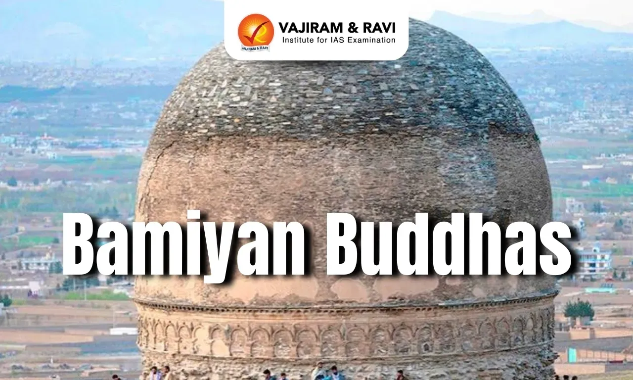
- The Bamiyan Buddhas, carved in the 6th century CE, were two monumental statues of standing Buddhas measuring 115 feet and 174 feet in height, embedded into the sandstone cliffs of Bamiyan Valley, central Afghanistan.
- These statues are considered exemplary of the Gandhara School of Buddhist Art, which reflected a unique blend of Indian, Persian, and Greco-Roman artistic influences.
- The Bamiyan Buddhas, named Salsal (meaning “light shines through the universe”) and Shamama (“Queen Mother”), stood 55 metres and 38 metres tall, respectively.
- These statues represented a fusion of Gupta, Sassanian, and Hellenistic styles, representing a unique confluence of civilisations.
- The statues represented the confluence of cultural traditions and were significant markers of the spread of Buddhism across Central and South Asia between the 1st and 13th centuries.
Background of Destruction
- The Taliban, a hardline group that emerged in the 1990s, imposed an extremist interpretation of Islamic law, which included banning art, education for girls, and public expression.
- On 27 February 2001, the Taliban officially announced its plan to demolish the Bamiyan Buddhas, deeming them un-Islamic.
- Over 25 days, the statues were systematically destroyed using explosives, marking one of the most egregious acts of cultural vandalism in modern history.
- In 2003, UNESCO designated the Bamiyan Valley as a World Heritage Site, despite the irreversible damage done.
- In 2021, a 3D holographic projection temporarily recreated the statue of Salsal, offering a new way to engage with the lost heritage.
Bamiyan Buddhas FAQs
Q1. Where are the Bamiyan Buddhas located?
Ans. The Bamiyan Buddhas were located in the Bamiyan Valley of central Afghanistan, carved into cliffs during the 6th century CE.
Q2. Why were the Bamiyan Buddhas destroyed?
Ans. They were destroyed in 2001 by the Taliban regime, who deemed them idolatrous, sparking international condemnation and loss of cultural heritage.
Q3. What is the historical significance of the Bamiyan Buddhas?
Ans. They reflect a fusion of Greco-Buddhist art, showing the spread of Mahayana Buddhism along the Silk Road.
Source: TH
Arctic Amplification
23-04-2025
12:33 PM

Arctic Amplification Latest News
According to the 2024 European State of the Climate Report, Europe has warmed nearly twice as much as the global average, with far-reaching climatic and ecological consequences.
What is Arctic Amplification?
- Arctic amplification is a phenomenon where temperature changes in the polar regions, especially the Arctic, are more intense than the global average temperature change.
- It is a form of polar amplification, which occurs when changes in Earth’s atmosphere lead to a greater rise in temperatures near the poles than in other parts of the world.
- This effect is measured against the average temperature rise of the planet and is particularly pronounced in the northern polar regions, hence the term Arctic amplification.
- The phenomenon is primarily driven by changes in the net radiation balance of the atmosphere, especially due to the increase in greenhouse gases like CO₂ and methane, which trap more heat in the Arctic region.
- The major contributing factors to Arctic amplification are: Ice-Albedo Feedback, Lapse Rate Feedback, Water Vapour Feedback & Ocean Heat Transport.
Key Highlights from the 2024 European State of the Climate Report
- The Arctic region is warming three to four times faster than the global average, a phenomenon called Arctic Amplification.
- This is due to the melting of Arctic ice, reducing the albedo effect, where ice (which reflects sunlight) is replaced by darker surfaces (land or water) that absorb more solar radiation, enhancing warming.
- Warming Trends in Europe vs. Global Averages:
- The global average temperature has risen by approximately 1.3°C above pre-industrial levels (1850–1900 baseline).
- In 2024, the planet crossed the critical 1.5°C threshold for the first time.
- Europe’s average temperature has increased by about 2.4°C, making it one of the fastest-warming regions on Earth.
- This accelerated warming has led to extreme weather events, including intense heat waves, heavy rainfall, and flooding.
- Regional Climatic Contrasts Within Europe:
- The Eastern part of Europe experienced warmer and sunnier conditions.
- Western Europe witnessed cloudier and wetter weather.
- Southeastern European countries (e.g., Bulgaria, Romania, Serbia, Croatia) saw their longest heatwave on record in 2024.
- The number of ‘cold stress days’ was the lowest ever, and below-freezing temperature days dropped significantly.
Arctic Amplification FAQs
Q1. What is Arctic Amplification?
Ans. Arctic Amplification refers to the phenomenon where the Arctic region warms at a rate faster than the global average due to ice-albedo feedback.
Q2. What causes Arctic Amplification?
Ans. It is caused by the melting of reflective ice, which exposes darker ocean surfaces that absorb more heat, accelerating warming.
Q3. How does Arctic Amplification affect global climate?
Ans. It disrupts jet streams, increases extreme weather events, and accelerates sea level rise due to melting ice sheets.
Source: IE
Quantum Gravity Gradiometer (QGG)
23-04-2025
11:32 AM

Quantum Gravity Gradiometer (QGG) Latest News
NASA scientists have proposed an innovative use of cold atom-based quantum gravity gradiometers (QGGs) to measure how the Earth’s mass distribution is changing, especially due to climate change.
About Quantum Gravity Gradiometer (QGG)
- Quantum Gravity Gradiometer (QGG): NASA scientists propose placing a Quantum Gravity Gradiometer onboard a satellite to detect minute gravitational changes.
- In a QGG, atoms of a specific element are cooled to near absolute zero in a vacuum, transforming them into wave-like states.
- Lasers manipulate these atoms, and the atoms undergo a phase shift directly related to the gravitational force acting upon them.
- This setup can detect differences in acceleration as small as 10⁻¹⁵ m/s² over a distance of just 1 meter.
- This includes estimating the mass of large formations like the Himalayas and monitoring the movement of water, ice, and geological materials with extreme precision from low Earth orbit.
- Gravitational force varies with mass distribution: The gravitational force experienced at different points on the Earth’s surface is not uniform; it depends on the mass of nearby objects.
- For instance, gravitational force near a mountain range is stronger than in less dense regions, like cities or flat plains.
- Gravity Gradiometer: It is a highly sensitive instrument that measures how gravitational acceleration changes from one place to another.
- For example, when a ball is dropped, the acceleration due to gravity can vary slightly depending on local mass differences.
- These devices are used in resource exploration—like locating hydrocarbon deposits, as oil and gas are less dense than surrounding rock.
Quantum Gravity Gradiometer (QGG) FAQs
Q1. What is a Quantum Gravity Gradiometer?
Ans. A Quantum Gravity Gradiometer is a highly sensitive instrument that measures tiny variations in Earth's gravitational field using quantum principles such as atom interferometry.
Q2. What is the significance of using quantum technology in gravity mapping?
Ans. Quantum-based gravity sensors can detect underground structures like cavities, tunnels, or mineral deposits with greater precision than conventional gravimeters, making them useful in geology, archaeology, and defence.
Q3. How does a Quantum Gravity Gradiometer work?
Ans. It works by tracking the motion of ultracold atoms in free-fall, which behave as quantum wavefunctions, and detecting phase shifts caused by gravity variations.
Source: SP
Cloudburst
23-04-2025
12:38 PM

Cloudburst Latest News
Recently, the Ramban district of Jammu and Kashmir witnessed torrential rainfall and hail, resulting in severe damage.
- The India Meteorological Department (IMD) reported 16.9 mm of rainfall in 24 hours, marking a 575% increase from the normal 2.5 mm.
What is a Cloudburst?
- A cloudburst is a localised and extremely intense rainfall event, defined by rainfall of 10 cm or more within one hour over an area of approximately 10 km × 10 km.
- Even 5 cm of rain in 30 minutes over the same area qualifies as a cloudburst.
- Cloudbursts are more common in mountainous regions due to a process known as orographic lift. In this phenomenon:
- Warm air ascends the mountain slope and expands due to lower atmospheric pressure at higher altitudes.
- As it expands and cools, the air releases its moisture in the form of precipitation.
- When large volumes of warm, moist air keep rising and accumulating moisture without releasing it, it can lead to a sudden, violent downpour.
- Because of their localised nature, cloudbursts are difficult to forecast and can overwhelm drainage systems, resulting in flash floods and landslides.
What is a Flash Flood?
- A flash flood is a sudden and rapid inundation that occurs when excessive rainwater enters streams, drains, or rivers, often overwhelming the natural or built drainage capacity.
- These are more frequent in mountainous regions where the rocky terrain absorbs little water, causing more surface runoff.
- Unlike riverine floods in plains that cause long-term property damage, flash floods tend to be more deadly, often catching people off guard and leading to loss of life.
What is a Landslide?
- A landslide refers to the movement of rock, debris, or earth down a slope, typically triggered when the force of gravity exceeds the resisting strength of the slope.
- Heavy rainfall plays a critical role in causing landslides by:
- Increasing the weight of the slope material.
- Reducing cohesion and friction, which makes it easier for soil and rocks to slide.
- Water infiltration from intense rain destabilises the slope, making landslides more likely.
- Landslides can:
- Crush living beings under debris.
- Disrupt roads and transportation.
- Block rivers, potentially causing secondary flooding.
Cloudburst FAQs
Q1. What is a Cloudburst?
Ans. A cloudburst is an extremely intense rainfall event, usually localised, where more than 100 mm of rain may fall in an hour, often leading to flash floods.
Q2. Where are cloudbursts most common in India?
Ans. They frequently occur in the Himalayan regions, especially in Uttarakhand, Himachal Pradesh, and Jammu & Kashmir, due to orographic lift and weather instability.
Q3. What causes a cloudburst?
Ans. It results from the sudden condensation of moisture-laden clouds, often enhanced by topography and local convergence zones.
Source: IE
Jwaneng Diamond Mine
23-04-2025
06:29 AM

Jwaneng Diamond Mine Latest News
The Jwaneng Diamond Mine is the richest diamond mine globally, with an estimated value of 1 billion euros.
About Jwaneng Diamond Mine
- Jwaneng Diamond Mine, dubbed the 'Prince of Mines,' is located in Botswana.
- It is the world's richest diamond mine by value.
- The mine lies on the edge of the Kalahari Desert.
- It is situated in an ancient volcanic crater about 170 km southwest of Botswana's capital, Gaborone.
- The mine is operated by Debswana, a joint venture between De Beers, a leading diamond company, and the Botswana government.
- Jwaneng, which means "a place of gems" in Setswana, sits atop a kimberlite pipe, a volcanic formation that brings diamonds from deep within the Earth's mantle to the surface.
- The mine's history dates back to the 1970s when De Beers discovered the site, and it has been operating since 1982.
- Over the years, it has produced millions of carats of diamonds from its three main kimberlite pipes.
- In 2023 alone, Jwaneng produced 13.3 million carats, solidifying its reputation as the world's richest diamond mine, valued at an estimated £1 billion.
- Jwaneng has played a crucial role in Botswana's economy. It is estimated that the mine's revenue has crossed $96 billion since its inception.
- Mining at Jwaneng is highly advanced, with large drills loosening the rock, and trucks transporting it to a processing plant.
- Here, diamonds are separated using state-of-the-art technologies like X-ray and laser sorters.
- Jwaneng was the first in Botswana to receive ISO 14001 certification for its eco-friendly practices.
Jwaneng Diamond Mine FAQs
Q1. In which country is the Jwaneng Diamond Mine located?
Ans. Botswana
Q2. What natural formation is the Jwaneng Mine located in?
Ans. Kimberlite pipe
Q3. Which company jointly operates the Jwaneng Mine with the Botswana government?
Ans. De Beers
Source: NDTV