RK-251 Drug

RK-251 Drug

RK-251 Drug Latest News

Recently, the Ministry of Science and Technology informed, about a new smart drug named RK-251 that can replace traditional chemotherapy. 

About RK-251 Drug

  • It is a smart cancer drug designed to activate primarily in cancer cells and does not harm healthy cells.
  • It is developed in collaboration with Dr. Asis Bala from the Institute of Advanced Study in Science and Technology (IASST) and Dr. K.P. Bhabak from the Indian Institute of Technology-Guwahati.
  • Working Mechanism
    • When RK-251 enters a cancer cell with high reactive oxygen species (ROS) levels, these molecules trigger the drug’s activation, releasing an anticancer compound called NBDHEX.
    • NBDHEX blocks target proteins that many cancer cells use to survive and resist treatment. 
    • The idea is to keep RK-251 relatively inactive in normal tissues and activate its anticancer action inside cancer cells.
    • It exhibited strong activity against aggressive triple-negative breast cancer cells, with much less effect on healthy cells.
    • It displayed the desired fluorescence in the presence of reactive oxygen species.
      • The fluorescence response also provides an indication that the drug is being activated in an ROS-rich environment, supporting the underlying mechanism of the targeted approach.

Source: News On Air

RK-251 Drug FAQs

Q1: RK-251 is a drug candidate developed for the treatment of which disease?

Ans: Cancer

Q2: What is the key advantage of RK-251 over conventional chemotherapy?

Ans: It attacks only cancer cells and spares healthy cells

Parichha Dam

Parichha Dam

Parichha Dam Latest News

Recently, the International Commission on Irrigation and Drainage (ICID) has recognized the historic Parichha dam as a ‘World Heritage Irrigation Structure (WHIS)’. 

About Parichha Dam

  • Location: It is located on Betwa River in Jhansi, Uttar Pradesh.
  • It is a key component of Betwa Canal System, which supplies water for agriculture to drought-prone areas of Bundelkhand.
  • Parichha Dam has played an important role in the irrigation system of Bundelkhand for nearly 140 years.
  • It benefits irrigation in several areas of Uttar Pradesh and Madhya Pradesh.
  • Historical Background
    • In 1855, Captain Strachey proposed developing a canal system for Bundelkhand, following which surveys were undertaken.
    • Construction of the dam began in 1881 and it became operational in 1886.
  • Others in the World Heritage Irrigation Structure list: In 2022, the Sukwa-Dukwan Weir in Jhansi was included in the ICID heritage list

International Commission on Irrigation and Drainage

  • It was established in 1950.
  • It is a leading scientific, technical, international not-for-profit, non-governmental organization.
  • Mission: ICID's mission is to promote ‘Sustainable agriculture water management’ to achieve ‘Water secure world free of poverty and hunger through sustainable rural development’.
  • It is working on irrigation, drainage and flood management.
  • Under its WHIS programme, the ICID recognises historically significant irrigation and drainage structures for their engineering, historical and continuing significance.
  • Criteria for World Heritage Irrigation Structure: 
    • The structure shall be more than 100 years old;
    • The structures shall fall under one of the following categories:
      • Dams (operational largely for irrigation purpose),
      • Water storage structures such as tanks for irrigation,
      • Barrages and other water diversion structures,
      • Canal Systems,
      • Old waterwheels,
      • Old shadouf,
      • Agriculture drainage structures,
      • Any site or structure functionally related to present or past agricultural water management activity.

Source: News On Air

Parichha Dam FAQs

Q1: Parichha Dam is located on which river?

Ans: Betwa River

Q2: Parichha Dam is situated in which state?

Ans: Uttar Pradesh

Pradhan Mantri Janjatiya Vikas Mission

Pradhan Mantri Janjatiya Vikas Mission

Pradhan Mantri Janjatiya Vikas Mission Latest News

The government is seeking to strengthen the forest-based economy through the Pradhan Mantri Janjatiya Vikas Mission (PMJVM). 

About Pradhan Mantri Janjatiya Vikas Mission

  • It was launched in 2021-22 to create a more organised system for tribal communities to process, add value to and market Minor Forest Produce.
  • The mission seeks to move tribal communities beyond selling raw forest produce by providing them with skills, technology, infrastructure and market linkages.
  • Objective: It has the objective to strengthen the tribal forest economy by combining traditional knowledge and locally available resources with modern processing, technology and market access.
  • This mission provides support at different stages, from collection and processing to marketing.
    • Skill development: Tribal gatherers are trained in scientific harvesting, processing and value addition.
    • Infrastructure: Van Dhan Vikas Kendra (VDVK) receives support for setting up facilities at beneficiaries’ homes or in government or Gram Panchayat buildings.
    • Processing equipment: Depending on the locally available produce, centres can receive equipment such as cutting and sieving tools, decorticators, dryers and packaging equipment.
    • Working capital: Financial linkages are facilitated through banks, financial institutions and the National Scheduled Tribes Finance and Development Corporation.
    • Storage and transportation: Support is also provided for storage and transportation on a rental basis.
  • A key component of the mission is the Van Dhan Vikas Kendra (VDVK) model.
    • VDVKs bring tribal forest gatherers together through self-help groups and help them undertake primary processing and value addition.
    • A VDVK is generally formed by clustering around 15 self-help groups, comprising about 300 tribal members.
    • At least 60 per cent of the members are required to belong to Scheduled Tribe communities.
    • The Van Dhan Yojana, launched in 2018, forms the foundation of this model.

Source: PIB

Pradhan Mantri Janjatiya Vikas Mission FAQs

Q1: Pradhan Mantri Janjatiya Vikas Mission is implemented by which Ministry?

Ans: Ministry of Tribal Affairs

Q2: What is the primary objective of Pradhan Mantri Janjatiya Vikas Mission?

Ans: Livelihood promotion through value addition to MFP and entrepreneurship

Divyastra Mk3

Divyastra Mk3

Divyastra Mk3 Latest News

Kawa UAV Pvt. Ltd., a defence start-up based in Lucknow, Uttar Pradesh, on Sunday announced that it successfully conducted a maiden flight test of the Divyastra Mk3.

Why in News?

  • The maiden flight marks the first instance in India's defence history of an indigenously designed, developed, and manufactured jet-powered loitering munition fitted with a fully indigenous powerplant taking to the skies.

About Divyastra Mk3

  • It is an indigenous loitering munition (kamikaze drone or suicide drone).
  • It was developed by Lucknow-based defence startup Kawa UAV Pvt. Ltd  (HoverIt).
  • It is designed to destroy high-value enemy assets, infrastructure, and personnel in a warzone by striking the target directly with an onboard explosive warhead.

Divyastra Mk3 Features

  • It is powered by an indigenous jet-propulsion system developed by New Delhi-based DG Propulsion.
  • While official specifications have not been disclosed, indicative data puts the UAV’s range at around 300-400 km, its speed at 250-300 kmph and its warhead capacity at up to 15-20 kg.
  • It features autonomous flight control and AI-enabled target-engagement capabilities.

Why Does Jet Propulsion Matter?

  • Its propulsion system sets it apart from many conventional drones and one-way attack UAVs because it uses a jet engine rather than a propeller-driven piston engine or an electric motor.
  • Conventional UAVs such as Iran’s Shahed-136 use an internal-combustion engine to drive a propeller, an architecture that generally prioritises endurance, simplicity, and relatively low-cost operation. 
  • Divyastra Mk3, by contrast, uses a compact indigenous jet engine designed to give it a higher speed. 
  • This could reduce the time available for an adversary to detect, track, and engage the incoming weapon. 
  • This makes the Mk3 closer in concept to a small jet aircraft than to a conventional propeller-driven UAV.

News: MC

Divyastra Mk3 FAQs

Q1: What is Divyastra Mk3?

Ans: Divyastra Mk3 is an indigenous loitering munition, also known as a kamikaze drone or suicide drone.

Q2: Which company developed Divyastra Mk3?

Ans: It was developed by Lucknow-based defence startup Kawa UAV Pvt. Ltd. (HoverIt).

Q3: What is the primary purpose of Divyastra Mk3?

Ans: It is designed to destroy high-value enemy assets, infrastructure and personnel in a warzone.

Q4: What type of propulsion system powers Divyastra Mk3?

Ans: It is powered by an indigenous jet-propulsion system.

Christmas Island

Christmas Island

Christmas Island Latest News

SpaceX has recently towed Starship to waters off Christmas Island after the spacecraft floated in the Indian Ocean for nearly 24 days.

About Christmas Island

  • It is a special territory of Australia located in the Indian Ocean. 
  • It lies about 360 km south of the island of Java and 1,400 km northwest of Australia.
  • The island is the summit of an oceanic mountain whose highest point on the island is Murray Hill, rising to 1,184 feet (361 metres) in the western part of the island. 
  • The island has steep cliffs along most of its coast. 
  • The main settlement and chief port is at Flying Fish Cove on the northeastern part of the island.
  • History:
    • Although Europeans sighted Christmas Island in 1615, it was named for the day of its rediscovery in 1643.
    • The discovery of phosphate on the island in 1887 led to the UK annexing it the following year. 
    • In 1900 Christmas Island was incorporated into the British crown colony of the Straits Settlements with its capital at Singapore. 
    • During World War II the island was occupied by the Japanese. 
    • In 1958 the island became an Australian territory.
  • Most of the island is covered in tropical rainforest. Much of the island (63%) is a national park. 
  • One of the island’s best-known animal residents is the Christmas Island red crab (Gecarcoidea natalis), whose spectacular annual emergence and migration draws large numbers of tourists.
  • The reefs around Christmas Island have healthy coral. They are home to several rare marine animals. 
    • These reefs, along with those near the Cocos (Keeling) Islands, are sometimes called "Australia's Galapagos Islands". 
  • The population includes many ethnic Chinese, a small number of people of European ancestry, and Malay labourers recruited mainly from Malaysia, Singapore, and the Cocos (Keeling) Islands.
  • Economy: 
    • The economy was completely based on phosphate mining and extraction earlier. 
    • With the mineral close to exhaustion now, subsistence cropping, fishing, and tourism serve as the backbone of its economy.

News: IT

Christmas Island FAQs

Q1: Where is Christmas Island located?

Ans: It is located in the Indian Ocean, about 360 km south of Java and 1,400 km northwest of Australia.

Q2: What is the highest point of Christmas Island?

Ans: Murray Hill, which rises to about 361 metres (1,184 feet).

Q3: What type of vegetation covers most of Christmas Island?

Ans: Tropical rainforest covers most of the island.

Q4: Which communities form a significant part of the population of Christmas Island?

Ans: The population includes many ethnic Chinese, people of European ancestry, and Malay labourers.

Sea Urchin

Sea Urchin

Sea Urchin Latest News

Researchers from IIT Mandi have developed a sea urchin inspired surface coating on 3D-printed bone implants capable of mechanically disrupting bacteria and accelerating integration of the implant with bones. 

About Sea Urchin

  • It belongs to a group of marine invertebrates called echinoderms, which means spiny-skinned animals. 
  • It includes other well-known marine creatures like starfish and sea cucumbers.
  • Habitat: They can be found in various marine environments, including rocky shores, coral reefs, seagrass beds, and sandy bottoms. They live on the ocean floor, usually on hard surfaces, and use tube feet or spines to move about.
  • Appearance: Sea urchins are characterized by their spherical to somewhat flattened, spiny bodies.
  • Features
    • They have a globular body and a radial arrangement of organs, shown by five bands of pores running from mouth to anus over the test (internal skeleton).
    • The pores accommodate tube feet, which are slender, extensible, and often sucker-tipped. 
    • They have a hard exoskeleton, or test, made up of interlocking plates or ossicles, which are often covered with movable spines.
    • From nodules on the test arise long, movable spines and pedicellariae (pincerlike organs); these structures may have poison glands.
  • Food Habit: They are herbivorous, primarily feeding on algae and plant material.
  • They use their specialized mouthparts, called Aristotle’s lantern, to scrape algae and other food sources from rocks or the seafloor.

Source: DD News

Sea Urchin FAQs

Q1: Sea Urchin belongs to which Phylum?

Ans: Echinodermata

Q2: Sea Urchins are primarily found in which habitat?

Ans: Marine ecosystem

AIKosh Platform

AIKosh Platform

AIKosh Platform Latest News

Recently, a workshop on the AIKosh platform was organised at the India Habitat Centre, New Delhi.

About AIKosh Platform

  • It is a national platform for datasets, AI models and related resources.
  • It aims to enhance access to datasets and models from various sources to boost AI innovation, support AI solution development with shared toolkits, and showcase use cases to inspire new applications.
  • It is designed to enable greater discoverability, access and responsible use of AI-ready resources for India's AI ecosystem.
  • It also features AI sandbox capabilities through an integrated development environment along with tools and tutorials.
  • It is an initiative under the IndiaAI Mission.
  • Nodal Ministry: Ministry of Electronics and Information Technology (MeitY).

What is IndiaAI Mission?

  • It was initially launched as a joint initiative between the Ministry of Electronics and Information Technology and Nasscom in 2023. 
  • Aim: To bolster India’s AI ecosystem by making high-end computing resources accessible to startups and researchers.
  • Implementing agency: IndiaAI an independent business division under the Ministry of Electronics and Information Technology (MeitY).
  • Pillars of the IndiaAI Mission
    • Common Compute Facility
    • AI Kosha (IndiaAI Datasets Platform)
    • AI Safety Institute of India (Upcoming)
    • IndiaAI Innovation Centre
    • AI Application Development Initiative
    • Future Skills Initiative
    • Startup Financing

Source: PIB

AIKosh Platform FAQs

Q1: AIKosh Platform is launched under which Mission?

Ans: IndiaAI Mission

Q2: AIKosh Platform is managed by which Ministry?

Ans: Ministry of Electronics & IT

Singhbhum Craton

Singhbhum Craton

Singhbhum Craton Latest News

Researchers recently identified a 3.5-billion-year-old layered rock formation within the Singhbhum craton in eastern India that could contain some of the earliest chemical evidence of life on the planet.

About Singhbhum Craton

  • The Singhbhum Craton, located in eastern India (Jharkhand and Odisha states) between the Chhota Nagpur plateau and the Eastern Ghats, is one of the oldest and most important cratons in the Indian Shield. 
    • A craton is a stable continental block composed of ancient crystalline rocks, typically surrounded by mobile belts. 
    • Studying them offers a window into how processes within and on the surface of Earth operated in the past.  
  • It represents a fragment of the ancient Gondwana supercontinent and holds significant geological and economic importance due to its rich mineral resources. 
  • This ancient part of the Earth’s crust has been found in previous research to date back to 3.5 billion years ago.
  • The craton’s oldest rock assemblages are largely volcanic and sedimentary rocks, also known as greenstone successions.
    • Greenstones are rock assemblages made up mostly of sub-marine volcanic rocks with minor sedimentary rocks.
  • The geology of this area shares stark similarity with the greenstone belts documented in South Africa’s Barberton and Nondweni areas and the Pilbara Craton in western Australia.
    • All these areas experienced widespread submarine mafic — meaning high in magnesium oxide — volcanic eruptions between 3.5 and 3.3 billion years ago, preserved as pillowed lava and komatiites.
  • Significance:
    • They offer a clearer picture of Earth’s early tectonic activities during the Archaean times, contributing to our understanding of the planet’s formative years.
    • The Singhbhum Craton’s unique geological features, including its greenstone belts, provide invaluable information about Earth’s surface and atmospheric processes.
    • This is crucial for hypothesising early habitable conditions and the emergence of life on Earth.

News: BS

Singhbhum Craton FAQs

Q1: What is the Singhbhum Craton?

Ans: The Singhbhum Craton is one of the oldest and most important cratonic blocks of the Indian Shield, located in eastern India.

Q2: Where is the Singhbhum Craton located?

Ans: It is located mainly in Jharkhand and Odisha in eastern India.

Q3: How old is the Singhbhum Craton?

Ans: Parts of the Singhbhum Craton date back to about 3.5 billion years.

Q4: What is the geological significance of the Singhbhum Craton?

Ans: It provides important evidence about Earth’s early crustal evolution and geological processes.

National Centre for Polar and Ocean Research

National Centre for Polar and Ocean Research (NCPOR)

National Centre for Polar and Ocean Research Latest News

Recently, the Ministry of Earth Sciences organized the 8th Meeting of the BRICS Working Group on Ocean Polar Science and Technology (OPST) at Goa, hosted by the National Centre for Polar and Ocean Research (NCPOR). 

About National Centre for Polar and Ocean Research

  • It was established as an autonomous Research and Development Institution on the 25th May 1998.
  • It was formerly known as the National Centre for Antarctic and Ocean Research (NCAOR).
  • It has been at the forefront of leading India’s scientific expeditions and research programmes in the Polar Regions and the Southern Ocean.
  • Nodal Ministry: Ministry of Earth Sciences Government of India
  • Location: Vasco da Gama, Goa

Functions of National Centre for Polar and Ocean Research

  • It is designated as the nodal organization for the co-ordination and implementation of the Indian Antarctic Programme, and executing polar expeditions in the Antarctic, Arctic, Southern Ocean, and Himalayas.
  • It also works on strategically vital projects like: Mapping of Exclusive Economic Zone (EEZ), Continental shelf surveys, and the Deep Ocean Mission.
  • It has established and operationalised permanent Indian research stations — DakshinGangotri, Maitri, and Bharati in Antarctica, and Himadri in the Arctic, along with the Himalayan station Himansh.

Source: PIB

National Centre for Polar and Ocean Research FAQs

Q1: Where is National Centre for Polar and Ocean Research headquartered located?

Ans: Vasco da Gama, Goa

Q2: National Centre for Polar and Ocean Research functions under which Ministry?

Ans: Ministry of Earth Sciences

Zambia

Zambia

Zambia Latest News

Recently, the Prime Minister of India has congratulated Hakainde Hichilema on being re-elected as the President of Zambia. 

About Zambia

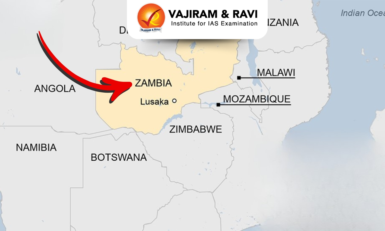
  • It is a Southern-Central African landlocked country.
  • Bordering Countries: It is bounded by the Democratic Republic of the Congo (North), Zimbabwe and Botswana (South), Tanzania (North-east), Malawi ( West) and Mozambique (Southeast), Angola and Zambia (West) and Namibia to the southwest.
  • Capital City: Lusaka.

Geographical Features of Zambia

  • Climate: It has a sub-tropical climate that is tempered by its relatively high altitude, making it more temperate and pleasant than other sub-tropical areas.
  • Rivers: The most significant river is the Zambezi River (which empties into the Indian Ocean). Other major rivers include the Kafue and the Luangwa.
  • Mountain Range: Mafinga Mountains.
  • Lakes: Lake Tanganyika and Lake Kariba
  • Natural Resources: It majorly consists of copper, cobalt, silver, uranium, lead, coal, zinc, gold, and emerald.

Source: News On Air

Zambia FAQs

Q1: Which river forms Victoria Falls?

Ans: Zambezi River

Q2: What is the capital of Zambia?

Ans: Lusaka

Enquire Now