Vasundhara Lake

Vasundhara Lake

Vasundhara Lake Latest News

The Uttarakhand state is installing the first early-warning system at Vasundhara Tal in Chamoli to monitor it in real time. 

About Vasundhara Lake

  • Location: It is a high-altitude glacial lake located in Chamoli district of Uttarakhand.
  • It is situated at an elevation of about 4,795 meters in the Raikana valley.
  • It serves as an originating source for the Dhauliganga River, a vital tributary of the Alaknanda.
  • The lake sits at the snout of the Raikana Glacier which is the primary source of this lake.
  • It was classified as Category A, the highest-risk category lake by the National Disaster Management Authority (NDMA).

What will the Vasundhara System Monitor?

  • The system will track water level, weather, snow conditions, water flow and movement around the lake.
  • Components and Working
    • A water-level sensor will monitor fluctuations and abnormal changes.
    • An automatic weather station will record temperature, humidity, rainfall, wind speed and direction, atmospheric pressure and light intensity.
    • Snow-depth and sub-surface temperature sensors will monitor changes in snow conditions.
    • Tilt and accelerometer sensors will detect movement and vibrations at selected locations, while a water-flow sensor will monitor changes in discharge.
    • The equipment will be powered through a solar-energy system, and data will be transmitted by satellite because conventional mobile networks are unavailable in the remote high-altitude region.
    • A data logger and monitoring dashboard will record the readings and generate alerts when predetermined thresholds are crossed.

Source: IE

Vasundhara Lake FAQs

Q1: Where is Vasundhara Lake located?

Ans: Uttarakhand

Q2: Vasundhara Lake is source of which river?

Ans: Dhauliganga River

Fukutoku-Okanoba Volcano

Fukutoku-Okanoba Volcano

Fukutoku-Okanoba Volcano Latest News

Japan’s Coast Guard recently reported signs of activity at the Fukutoku-Okanoba submarine volcano. 

About Fukutoku-Okanoba Volcano

  • It is an active submarine volcano that is part of the Volcano Islands of Japan in the Pacific Ocean.  
  • It is part of the Izu-Bonin arc formed by subduction of the Pacific Plate beneath the Philippine Sea Plate. 
  • Its summit is just 14 meters (46 feet) below sea level, allowing Surtseyan eruptions to breach the surface.  
  • Composition is tholeiitic basalt, typical of arc front volcanism. 
  • It remains active with intermittent submarine eruptions and discoloured water since 2013. 
  • Eruptions are explosive with pumice rafts, discoloured water, and occasional ephemeral island formation. 
  • The 2021 eruption produced massive pumice rafts that drifted thousands of kilometres across the Pacific, impacting shipping and beaches. 
  • The volcano's frequent activity and shallow depth make it one of the most dynamic submarines, with eruptions often detected by satellite discoloration.  

What is a Surtseyan Eruption?

  • It is a type of volcanic eruption that takes place in shallow seas or lakes. 
  • It is named after the island of Surtsey off the southern coast of Iceland. 
  • When magma rises close to the surface of the water, it can come into contact with the water and cause it to flash to steam. 
  • The sudden increase in volume of the steam can cause an explosion, which can fragment the magma into small pieces. 
  • These pieces of magma, called tephra, can be ejected into the air, forming an ash column. 
  • These eruptions are commonly phreatomagmatic eruptions, representing violent explosions caused by rising basaltic or andesitic magma coming into contact with abundant, shallow groundwater or surface water. 
  • Tuff rings, pyroclastic cones of primarily ash, are built by explosive disruption of rapidly cooled magma.
  • Surtseyan eruptions are relatively common, and they can be found all over the world.  
  • Surtseyan eruptions can be very dangerous. 
    • The ash and rock fragments that are ejected into the air can travel long distances, and they can be a hazard to ships and aircraft. 
    • The sudden expansion of steam can also cause shock waves, which can damage buildings and other structures.

News: REUT

Fukutoku-Okanoba Volcano FAQs

Q1: What is Fukutoku-Okanoba?

Ans: Fukutoku-Okanoba is an active submarine volcano in the Volcano Islands of Japan in the Pacific Ocean.

Q2: Which volcanic arc is Fukutoku-Okanoba part of?

Ans: It is part of the Izu-Bonin Arc.

Q3: What type of eruptions can occur at Fukutoku-Okanoba due to its shallow depth?

Ans: It can produce Surtseyan eruptions, which can breach the ocean surface.

Q4: What is the composition of Fukutoku-Okanoba Volcano?

Ans: It is composed mainly of tholeiitic basalt.

FAO Committee on Forestry

FAO Committee on Forestry

FAO Committee on Forestry Latest News

Recently, India showcased it’s forest and landscape restoration at the Twenty-eighth Session of the FAO (Food and Agriculture Organization) Committee on Forestry (COFO 28) held in Rome. 

About FAO Committee on Forestry

  • It is FAO’s (Food and Agriculture Organization) highest global intergovernmental body on forestry.
  • It guides the organisation’s work and fostering international collaboration, policy dialogue, and technical guidance on forest-related issues.
  • It was established by the Conference at its Sixteenth Session in 1971.
  • Governance
    • COFO reports to the FAO Council on matters related to programmes and budgets, and to the FAO Conference on policy and regulatory issues.
    • Its work is informed by six Regional Forestry Commissions, which review regional forestry priorities and inform global policy discussions.
    • Meetings: It convenes biennially (every two years) at the FAO headquarters in Rome, Italy
    • It brings together 128 Members, convening ministers, heads of forest services, senior government officials and partner organizations
  • Key Functions of Committee on Forestry
    • It reviews the programmes of work of the Organization in the field of forestry and reviews forestry problems of an international nature, evaluating said problems with a view to concerted action by Member Nations and the Organization.
    • It oversees the  Working Group on Dryland Forests and Agrosilvopastoral Systems, which supports the development of a comprehensive understanding of dryland ecosystems.  

Source: PIB

FAO Committee on Forestry FAQs

Q1: When was FAO Committee on Forestry?

Ans: It was established by the Conference at its Sixteenth Session in 1971.

Q2: What is the function of FAO Committee on Forestry?

Ans: It reviews the programmes of work of the Organization in the field of forestry.

PRAMAAN Certificate

PRAMAAN Certificate

PRAMAAN Certificate Latest News

Recently, the Union Environment, Forest and Climate Change Minister handed over India’s first PRAMAAN certificates under the Indian Forest and Wood Certification Scheme (IFWCS).

About PRAMAAN Certificate

  • PRAMAAN stands for Programme for Recognition and Accreditation of sustainable Management Practices for Agroforestry And Natural forestry resources.
  • Launched by: Ministry of Environment, Forest and Climate Change (MoEFCC)
  • It is a nationally accepted framework for certification of forests, wood and non-timber forest products.
  • Standards & Accreditation
    • Under the framework, Forest Management certification is assessed against Indian Forest Management Standards derived from the National Working Plan Code 2023.
    • PRAMAAN’s accreditation architecture is benchmarked against international frameworks, ensuring recognition among domestic and global buyers and regulators.
    • Audited by: The certification is audited by certification bodies accredited by the National Accreditation Board for Certification Bodies (NABCB) under the Quality Council of India.
  • Three types of Certification under IFWCS “PRAMAAN”
    • Forest Management (FM) Certification: For recorded forest areas and forest plantations, in accordance with the Indian Forest Management Standard
    • Trees Outside Forests (TOF) Management Certification: For agroforestry systems and private plantations in accordance with the Trees Outside Forests (Management) Standard
    • Chain of Custody (CoC) Management Certification: Ensures traceability of timber and non-timber forest products at each step of production, from its source to the customer.
  • Significance: The IFWCS-PRAMAAN certificate enhances the social, and ecological values of India’s forests, agroforestry systems and the Indian wood-based industries. 

Source: PIB

PRAMAAN Certificate FAQs

Q1: What is PRAMAAN Certificate?

Ans: It is a nationally accepted framework for certification of forests, wood and non-timber forest products.

Q2: Which ministry launched the PRAMAAN Certificate?

Ans: Ministry of Environment, Forest and Climate Change (MoEFCC)

Mandar Instrument

Mandar Instrument

Mandar Instrument Latest News

The traditional musical instrument Mandar, has received official recognition with a Geographical Indication tag. 

About Mandar Instrument

  • It is a traditional double headed percussion musical instrument deeply rooted in the folk culture and tribal life of Jharkhand.
  • Key Features of Mandar Instrument
    • Structure: It is characterised by its distinctive cylindrical shape made from red clay, which slightly bulges in the middle.
    • The structure is hollow, with its openings covered by leather on both sides.
    • The right opening is smaller, while the left is larger.
    • The leather coverings are secured using braided cords.
    • A special coating, known as Kiran, is applied to the smaller opening, giving Mandar its resonant and unique sound.
  • When played, the musician often moves rhythmically, carrying the instrument using a rope slung over the shoulder.
  • It serves as the primary instrument played during festivals, crop celebrations, religious rituals, and cultural events.
  • It is deeply integrated into the lives of both tribal and non-tribal communities, having been used for centuries in various dance and song performances.

Source: News On Air

Mandar Instrument FAQs

Q1: What is Mandar Instrument?

Ans: It is a traditional double headed percussion musical instrument deeply rooted in the folk culture and tribal life of Jharkhand.

Q2: What is the structure of Mandar Instrument?

Ans: It is characterised by its distinctive cylindrical shape made from red clay, which slightly bulges in the middle.

Didymocarpus nautiyalii

Didymocarpus nautiyalii

Didymocarpus nautiyalii Latest News

Botanists recently discovered a new plant species in Arunachal Pradesh’s Shi-Yomi district, highlighting the rich botanical diversity of the Eastern Himalaya.

About Didymocarpus nautiyalii

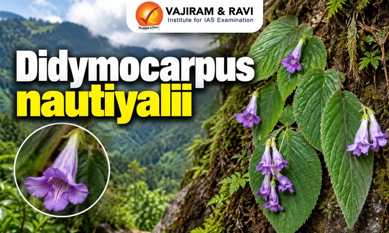
  • It is a new plant species.
  • It was discovered in Arunachal Pradesh’s Shi-Yomi district.
  • It belongs to the Gesneriaceae, a family of flowering plants. 
  • The small herb grows on moist rock surfaces, including roadside walls and areas near waterfalls, in subtropical evergreen forests at elevations above 1,000 metres. 
  • It grows to only around 8 cm and has leathery leaves and distinctive bluish-purple flowers. 
  • The plant resembles Didymocarpus albiflorus but differs in several characteristics, including its much shorter stem, very short or absent leaf stalks, leathery leaf blades, smaller calyx, shorter bluish-purple corolla, and a hairless ovary.   
  • The researchers have currently assessed D. nautiyalii as ‘Data Deficient’ under the IUCN Red List criteria.

News: TP

Didymocarpus nautiyalii FAQs

Q1: What is Didymocarpus nautiyalii?

Ans: Didymocarpus nautiyalii is a newly discovered plant species.

Q2: Where was Didymocarpus nautiyalii discovered?

Ans: It was discovered in Shi-Yomi district of Arunachal Pradesh.

Q3: What type of habitat does Didymocarpus nautiyalii prefer?

Ans: It grows on moist rock surfaces, including roadside walls and areas near waterfalls.

Q4: What are the distinctive features of Didymocarpus nautiyalii?

Ans: What are the distinctive features of Didymocarpus nautiyalii?

International Whaling Commission

International Whaling Commission

International Whaling Commission Latest News

India has reaffirmed its commitment to the conservation of whales and other cetaceans (marine mammals) at the 70th meeting of the International Whaling Commission (IWC-70) held in Hobart, Australia, recently.

About International Whaling Commission

  • It is an intergovernmental organization established to regulate whaling and promote the conservation of whale populations.   
  • It was established under the 1946 International Convention for the Regulation of Whaling. 
  • Formed in response to the alarming decline of whale stocks in the 1930s, the IWC initially aimed to ensure sustainable whaling practices among its member nations. 
  • The Convention also applies to factory ships, land stations, and whale catchers under the jurisdiction of the contracting governments, and to all waters in which they carry out whaling.  
  • Membership: 
    • Beginning in 1979, IWC membership started to grow: 23 members in 1979, 41 by 1985. Currently, there are 88 contracting governments. 
    • Countries that do not hunt whales can also join the IWC.
    • Some of the current members include: Australia, Brazil, China, Denmark, France, Germany, Iceland, India, Japan (until 2019), Mexico, New Zealand, Norway, Russia, South Africa, Sweden, United Kingdom, and United States.  
  • The IWC's main office is in Impington, near Cambridge, England. 
  • There are generally three types of whaling that the Commission regulates:
  • Commercial Whaling:
    • In 1986, a global moratorium, or a temporary ban, on commercial whaling was adopted due to the overexploitation of whale stocks. 
    • The Commission has also designated sanctuary areas in the Indian and Southern Oceans where commercial whaling is not allowed. 
    • Although the moratorium is still in place, some countries, such as Norway and Iceland, continue to engage in commercial whaling activities.
  • Scientific Research Whaling:
    • Article VIII of the Convention allows contracting governments to issue special permits authorizing the taking of whales for purposes of scientific research. 
    • Japan’s lethal scientific research in the North Pacific and Southern Oceans under such special permits ended in 2019 with their withdrawal from the Convention.
  • Subsistence Whaling:
    • The Commission also regulates aboriginal subsistence whaling (whaling by native people to sustain themselves). 
    • Currently, the Commission permits indigenous communities in Denmark (Greenland), the Russian Federation, St. Vincent and the Grenadines, and the United States to engage in this type of whaling on certain whale stocks. 
  • Over the years, the IWC has faced significant challenges. 
    • It does not have a way to force countries to follow its rules or punish them. 
    • It often becomes a platform for member nations to negotiate over whaling quotas rather than prioritizing conservation efforts. 
  • In 2018, the IWC members made the "Florianópolis Declaration." 
    • They decided that the IWC's main purpose is to protect whales forever.  
    • They also want all whale populations to return to their numbers before large-scale whaling began. 
    • The declaration also stated that using deadly methods for research is not needed.  
    • After this, Japan announced on December 26, 2018, that it was leaving the IWC.

News: NIE

International Whaling Commission FAQs

Q1: What is the International Whaling Commission (IWC)?

Ans: It is an intergovernmental organization established to regulate whaling and promote the conservation of whale populations.

Q2: What is the main purpose of the International Whaling Commission?

Ans: Its main purpose is to regulate whaling and promote the conservation of whale populations.

Q3: Where is the main office of the International Whaling Commission located?

Ans: It's main office is in Impington, near Cambridge, England.

Q4: Can countries that do not hunt whales become members of the International Whaling Commission?

Ans: Yes, countries that do not hunt whales can also join the IWC.

Q5: When was the global moratorium on commercial whaling adopted?

Ans: The global moratorium on commercial whaling was adopted in 1986.

Galaxy Frog

Galaxy Frog

Galaxy Frog Latest News

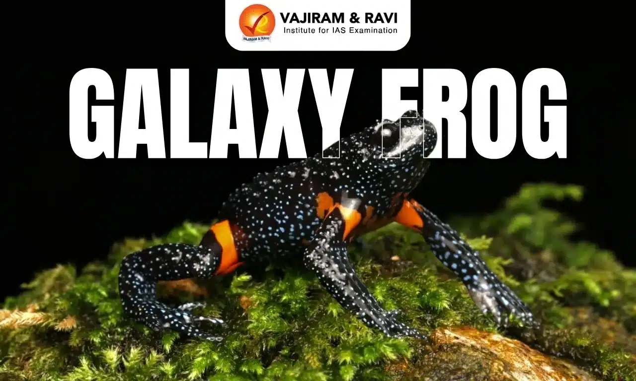
The rarely sighted Galaxy frog returned to the spotlight after the Additional Chief Secretary, Environment, Climate Change and Forests Department of Tamil Nadu, shared new images of the frog, as its galaxy-like spots are being studied.

About Galaxy Frog

  • It is a small, nocturnal amphibian. 
  • It is one of the rarest amphibians in the world.
  • The species was first described in 1878 from the Anamalai Hills of Tamil Nadu, and was later rediscovered in 1997, after decades in which it was exceptionally difficult to find.
  • It belongs to the family Microhylidae and sub-family Melanobatrachinae.
  • Scientific Name: Melanobatrachus indicus
  • It is the sole member of its genus. 

Galaxy Frog Habitat and Distribution

  • It is endemic to the southern Western Ghats, with records from parts of Kerala and Tamil Nadu. 
  • The rarely-sighted creature lives in wet evergreen and other moist forest habitats, generally at elevations of about 1,000 to 1,500 metres.
  • They are typically found in dark, moist places such as under the cover of leaf litter, rotting logs and rocks. 

Galaxy Frog Features

  • It has a slender, elongated body of uniform width. 
  • It measures just 2-3.5 centimeters in length.  
  • The amphibian's dark body is covered with tiny bluish-white spots that resemble stars, while flashes of scarlet-orange appear underneath. 

Galaxy Frog Conservation Status

It is classified as 'Vulnerable' under the IUCN Red List.

News: IT

Galaxy Frog FAQs

Q1: What is the Galaxy Frog?

Ans: The Galaxy Frog is a small, nocturnal amphibian and one of the rarest amphibians in the world.

Q2: What is the scientific name of the Galaxy Frog?

Ans: Melanobatrachus indicus.

Q3: Where is the Galaxy Frog endemic?

Ans: It is endemic to the southern Western Ghats, with records from parts of Kerala and Tamil Nadu.

Q4: Why is it called the Galaxy Frog?

Ans: Its dark body is covered with tiny bluish-white spots resembling stars, giving it a galaxy-like appearance.

Q5: What is the conservation status of the Galaxy Frog according to the IUCN Red List?

Ans: It is classified as Vulnerable.

Italy

Italy

Italy Latest News

Recently, the 2nd India–Italy Joint Working Group (JWG) on Tourism was held and agreed to strengthen bilateral cooperation in tourism. 

About Italy

  • Location: It is located in South-central Europe on the Apennine Peninsula.
  • Bordering Countries: It shares its border with Switzerland and Austria in the north, Slovenia in the northeast and France in the northwest.  
  • Vatican City and San Marino are the two enclaved sovereign states within Italy.
  • Maritime boundaries: It is bordered by the Adriatic Sea in the east, the Sea of Sicily in the south, the Ionian Sea in the southeast, the Ligurian Sea, and the Tyrrhenian Sea in the southwest.
  • Capital City: Rome

Geographical Features of Italy

  • Climate: The coastal region of Italy has a typical Mediterranean climate with mild winters and hot and mostly dry summers.
  • Topography: It is mostly rugged and mountainous and has some plains, coastal lowlands.
  • Mountain: The Apennine Mountains run along the length of the peninsula as a separate system and the Alps run along Italy's northern border.
  • Major Rivers: Po (It is Italy’s longest river) and Adige.
  • Highest Point: Mont Blanc 
  • Volcano: Italy is volcanic in origin, and a few of its many volcanoes are active, including Sicily’s Mt. Etna, Stromboli in the Aeolian Islands.
  • Natural Resources: Coal, antimony, mercury, zinc, potash, barite, asbestos, pumice, fluorspar, feldspar, pyrite (sulfur), natural gas and crude oil reserves.

Source: PIB

Italy FAQs

Q1: Where is Italy located?

Ans: It is located in South-central Europe on the Apennine Peninsula.

Q2: Which are the major rivers of Italy?

Ans: Po (It is Italy’s longest river) and Adige.

Unified Complex Radio Antenna

Unified Complex Radio Antenna

Unified Complex Radio Antenna Latest News

Japan recently called on India to fast-track internal official processing of the agreement on the UNICORN (Unified Complex Radio Antenna) naval radar system.

About Unified Complex Radio Antenna 

  • UNICORN, also known as NORA-50, is a shipborne integrated antenna system.
  • It is a mast with integrated communication systems that is engineered to dramatically enhance a warship's stealth and situational awareness. 
  • Developed jointly by three Japanese companies (NEC Corporation, Sampa Kogyo K.K., and The Yokohama Rubber Co., Ltd.), the system is already in service aboard Japan’s Mogami-class frigates. 
  • What does UNICORN do?
    • Conventional warships typically carry several exposed antennas – for radar, communications, and electronic warfare – bolted onto a mast. 
    • Each of these surfaces adds to a ship’s radar cross-section, making it easier for an adversary to detect.
    • UNICORN does away with that arrangement by consolidating multiple antennas into a single enclosed radome mounted on one mast, cutting down the number of reflective surfaces a hostile radar can pick up.
    • Its design stacks the antennas vertically inside a bar-shaped dome, moving components such as the tactical air navigation antenna from an exposed position at the top of the mast to a more sheltered spot lower down. 
    • A lightning diverter strip runs across the mast's surface as a safety measure, given the exposure of ships at sea to lightning strikes. 
    • Inside this unified mast are several vital subsystems, including those for tactical data links, Tactical Air Navigation Systems (TACAN), Identification Friend or Foe (IFF), Electronic Support Measures (ESM), and general communications. 
    • This innovation significantly reduces the cross-section of naval platforms, thereby enhancing their stealth characteristics and enabling them to operate with reduced electronic signatures. 
    • Beyond stealth, the system is also designed to reduce mutual interference between closely packed antennas, improve the range at which external radio signals can be detected, and simplify installation and maintenance.
  • India-Japan Agreement:
    • India and Japan signed a Memorandum of Implementation (MOI) on 15 November 2024 for the co-development of UNICORN masts. 
    • It is the first military hardware co-development pact between the two countries. 
    • Japan will provide the design and engineering support, while India will handle integration, adaptation, and co-production through Bharat Electronics Limited (BEL). 
    • The integrated mast is expected to gradually replace existing communication and sensor mast systems across the Navy's fleet.

News: TH

Unified Complex Radio Antenna FAQs

Q1: What is Unified Complex Radio Antenna (UNICORN)?

Ans: UNICORN is a shipborne integrated antenna system designed to enhance the stealth and situational awareness of warships.

Q2: What type of system is UNICORN?

Ans: It is a mast with integrated communication and sensor systems designed for naval platforms.

Q3: Which country developed the UNICORN integrated mast system?

Ans: Japan developed the UNICORN system.

Q4: What is the main stealth advantage of UNICORN?

Ans: It reduces the radar cross-section and electronic signature of naval platforms.

Q5: When did India and Japan sign the agreement for co-development of UNICORN masts?

Ans: India and Japan signed the Memorandum of Implementation (MOI) on 15 November 2024.

Enquire Now