Martian Moons Exploration Mission

Martian Moons Exploration Mission

Martian Moons Exploration Mission Latest News

Japan is preparing to launch an ambitious Martian Moons eXploration (MMX) mission to one of Mars’ mysterious moons, Phobos, by using Japan's H3 rocket.

About Martian Moons Exploration Mission

  • It is a mission of the Japan Aerospace Exploration Agency (JAXA). 
  • The mission will primarily focus on Phobos, a Martian moon that has never been explored.
  • Focus: It will observe the topography, internal structure, composition, and gravity of the moon, and return samples of sand.
  • It aims to collect at least 10 grams of material from Phobos and return it to Earth in 2031.
  • It will also study both Phobos and Deimos, Mars’ two small moons, to investigate their origins and evolution.
  • The mission will travel to the Martian system aboard Japan's H3 rocket from the Tanegashima Space Center.
  • It is scheduled to reach Mars in 2027.
  • It will deploy a small rover, developed jointly by the German Aerospace Center (DLR) and France's CNES, to study the surface and support exploration.
  • NASA is contributing two key technologies to this mission
    • MEGANE instrument, which will analyse the elemental composition of Phobos, and a pneumatic sampler designed to collect surface material.
    • Pneumatic sampler that uses high-pressure nitrogen gas to lift surface particles into a collection container.

Source: IT

Martian Moons Exploration Mission FAQ's

Q1: Martian Moons Exploration Mission is an initiative of which organisation?

Ans: Japan Aerospace Exploration Agency (JAXA). 

Q2: What is the aim of Martian Moons Exploration Mission ?

Ans: It aims to collect at least 10 grams of material from Phobos and return it to Earth in 2031.

YJ-21 Missile

YJ-21 Missile

YJ-21 Missile Latest News

Footage released by Chinese state media recently has for the first time shown the launch of a YJ-21 anti-ship ballistic missile by a Chinese People’s Liberation Army H-6K bomber, eight years after the missile was unveiled.

About YJ-21 Missile

  • The YJ-21, also known as the Eagle Strike 21, is a Chinese hypersonic anti-ship ballistic missile.  
  • It is designed for striking large, high-value naval targets, such as aircraft carriers. 
  • It entered service in 2022. 
  • Initially deployed on naval platforms, a bomber-launched variant was revealed in May 2024, significantly extending its operational reach.  

YJ-21 Missile Features

  • It is a solid-fueled, two-stage missile with unique aerodynamic and propulsion systems optimized for hypersonic flight.
  • The missile achieves cruise speeds exceeding Mach 6 during its midcourse phase and reaches terminal velocities up to Mach 10.  
  • It has a maximum range of approximately 1,500 km.
  • The missile’s high-speed trajectory is coupled with a quasi-ballistic flight path, allowing it to execute high-G maneuvers during its terminal approach. 
  • It uses an inertial navigation system (INS) as well as an active radar-homing or infrared terminal-state seeker.

News: MWM

YJ-21 Missile FAQs

Q1: What is the YJ-21 Missile?

Ans: The YJ-21 is a Chinese hypersonic anti-ship ballistic missile.

Q2: What is the primary objective of the YJ-21 Missile?

Ans: To strike large, high-value naval targets, such as aircraft carriers.

Q3: What is the approximate maximum range of the YJ-21 Missile?

Ans: Approximately 1,500 km.

Q4: Which navigation system does the YJ-21 Missile use?

Ans: An Inertial Navigation System (INS).

PUFFINS Telescope Mission

PUFFINS Telescope Mission

PUFFINS Telescope Mission Latest News

A Bengaluru-born astronomer Dr. Ramya Anche will be heading the $20 million NASA space telescope mission PUFFINS. 

About PUFFINS Telescope Mission

  • A PUFFIN (Polarimetry in the Ultraviolet to Find Features in INterStellar dust) is a SmallSat selected under NASA’s highly competitive Astrophysics Pioneers programme.
  • It is a NASA funded mission and is a joint effort between the University of Arizona, McDonald Observatory and other scientists.
  • It involves sending up a small satellite that will contain a telescope with an aperture of about 10 inches to observe the ultraviolet light of about 70 stars.
  • It will study the smallest grains of dust between the stars.
  • It will observe them using UV spectropolarimetry,
  • It gives scientists insights into the characteristics, presence, and behavior of interstellar dust particles.
  • The measurements are supposed to provide information on the particles’ characteristics and how they behave in relation to the magnetic field of the Milky Way galaxy.
  • The mission intends to bridge the gaps that exist in existing astronomy studies, especially those concerning the observation of interstellar dust particles using ultraviolet polarisation.
    • Interstellar dust refers to particles that exist in the space between the stars.
    • These particles have sizes ranging from less than 50 nanometers; therefore, they cannot be detected using the traditional optical or infrared techniques.

Source: TH

PUFFINS Telescope Mission FAQs

Q1: What is the aim of PUFFINS Telescope Mission?

Ans: It will study the smallest grains of dust between the stars.

Q2: What is Interstellar dust ?

Ans: Interstellar dust refers to particles that exist in the space between the stars.

National Strategic Trade Command Centre (NSTCC)

National Strategic Trade Command Centre (NSTCC)

National Strategic Trade Command Centre Latest News

The Commerce and Industry Minister recently launched the National Strategic Trade Command Centre (NSTCC) in New Delhi.

About National Strategic Trade Command Centre

  • It is a strategic initiative aimed at strengthening the monitoring, analysis, and governance of India’s international trade ecosystem through integrated data analytics and evidence-based decision-making. 
  • At its core is an integrated analytics and visualisation platform designed to convert trade-related data into actionable insights. 
  • It was developed by the Department of Commerce under the Ministry of Commerce and Industry. 
  • It will provide senior policymakers and government officials with a consolidated view of India’s trade performance, export promotion schemes, regulatory approvals, application processing, and operational indicators. 
  • It enables users to analyse information at multiple levels, including national trade performance, Regional Authorities, schemes, products, destination markets, and individual applications, subject to role-based access permissions. 
  • In its initial phase, the command centre brings together dashboards covering key functions of the Directorate General of Foreign Trade (DGFT) and related trade domains. 
    • These include the Importer Exporter Code (IEC), Advance Authorisation, Export Promotion Capital Goods (EPCG), Certificate of Origin (CoO), SCOMET (Special Chemicals, Organisms, Materials, Equipment and Technologies), restricted imports and exports, and other regulatory and trade facilitation processes. 
    • These dashboards will enable monitoring of scheme utilisation, processing efficiency, export obligations, trade patterns, and operational performance across regional authorities. 
  • The initiative has three main objectives: 
    • Improving the monitoring of trade and pending applications.
    • Comparing the performance of schemes and regional offices.
    • Using data to identify procedural hurdles and simplify regulations. 
  • The centre will also help officials identify export opportunities, assess how effectively businesses are using India's trade agreements, and track the country's position in international markets. 
  • It has been designed to leverage existing digital infrastructure, including DGFT systems and the Trade Connect ePlatform. 
  • It will also provide a framework for the phased integration of additional datasets from other departments and trade-related agencies. 
  • Going forward, the NSTCC is envisaged to evolve into a broader whole-of-government decision-support mechanism, with phased access for authorised stakeholders, including relevant ministries, states, Export Promotion Councils, and other institutions.

News: NOA

National Strategic Trade Command Centre FAQs

Q1: What is the National Strategic Trade Command Centre (NSTCC)?

Ans: It is a strategic initiative to strengthen the monitoring, analysis and governance of India's international trade through integrated data analytics.

Q2: What is the primary objective of National Strategic Trade Command Centre (NSTCC)?

Ans: To improve trade monitoring, support evidence-based decision-making and strengthen trade governance.

Q3: Which department developed the National Strategic Trade Command Centre (NSTCC)?

Ans: It was developed by the Department of Commerce under the Ministry of Commerce and Industry.

Q4: What is the core component of National Strategic Trade Command Centre (NSTCC)?

Ans: An integrated analytics and visualisation platform that converts trade-related data into actionable insights.

Financial Services Institutions Bureau

Financial Services Institutions Bureau

Financial Services Institutions Bureau  Latest News

Recently, the government reconstituted the Financial Services Institutions Bureau.

About Financial Services Institutions Bureau    

  • It is an autonomous body of the Government of India set up under the Department of Financial Services (DFS), Ministry of Finance.
  • It replaced the erstwhile Banks Board Bureau (BBB) in July 2022.
  • Structure: 
    • FSIB is headed by a chairman, a central government nominee. 
    • The board comprises the Secretaries of the DFS, the chairman of IRDAI, and a deputy governor of the RBI. 
    • Additionally, it will have three part-time members who are experts in banking and three more from the insurance sector. 

Functions of Financial Services Institutions Bureau

  • To recommend persons for appointment as whole-time directors (WTDs) and non-executive chairpersons (NECs) on the Boards of Directors in Public Sector Banks, financial institutions and Public Sector Insurers
  • To advise the Government on matters relating to appointments, transfer or extension of term of office and termination of services of the said directors;
  • To advise the Government on the desired management structure at the Board level for PSBs, FIs and PSIs;
  • To advise the Government on a suitable performance appraisal system for WTDs and NECs in PSBs, FIs and PSIs;
  • To advise the Government on formulation and enforcement of a code of conduct and ethics for whole-time directors in PSBs, FIs and PSIs;
  • To advise the Government on evolving suitable training and development programmes for management personnel in PSBs, FIs and PSIs;
  • To help PSBs, FIs and PSIs in terms of developing business strategies and capital raising plan etc.

Source: BL

Financial Services Institutions Bureau FAQs

Q1: What is Financial Services Institutions Bureau?

Ans: It is an autonomous body of the Government of India set up under the Department of Financial Services (DFS), Ministry of Finance.

Q2: The Financial Services Institutions Bureau replaced which organisation?

Ans: It replaced the erstwhile Banks Board Bureau (BBB) in July 2022.

Brihadiswara Temple

Brihadeeswarar Temple

Brihadiswara Temple Latest News

The Archaeological Survey of India (ASI) recently launched conservation works on the upper rampart of Brihadiswara Temple in Thanjavur.

About Brihadiswara Temple

  • Brihadiswara (Brihadeshwara) is a Hindu temple dedicated to Lord Shiva located in the city of Thanjavur in Tamil Nadu.
  • It is also known as Periya Kovil, RajaRajeswara Temple, and Rajarajesvaram. 
  • It is one of the largest temples in India and is an example of Dravidian architecture during the Chola period.
  • It was constructed under the patronage of the Chola emperor Rajaraja I between 1003 and 1010 CE. 
  • It is part of the UNESCO World Heritage Site known as the “Great Living Chola Temples”, with the other two being the Gangaikonda Cholapuram and Airavatesvara Temple, both constructed by Chola rulers and located northeast of Thanjavur. 

Brihadiswara Temple Architecture

  • It is a masterpiece of Dravidian architecture, which is characterized by the use of pyramid-shaped towers, pillared halls, enclosed courtyards, and sculpted walls. 
  • The temple complex spans over 40 acres and is decorated with masses of sculptures and inscriptions that spotlight the era’s devotion and craftsmanship.
  • The entire temple structure is made out of granite. The construction of the temple out of granite was done without mortar. 
  • The temple stands amidst fortified walls that were probably added in the 16th century. 
  • The central tower, or vimana, is 66 m high and is the tallest in the world. It is also the most ornate and elaborate, with intricate carvings and paintings.  
  • The Kumbam (the apex or the bulbous structure on the top) at the top of vimana is carved out of a single rock and weighs around 80 tons. 
  • There is a big statue of Nandi (sacred bull), carved out of a single rock measuring about 4.9 m long and 4.0 m high at the entrance. 
  • The temple complex is surrounded by two concentric rectangular enclosures (prakarams) with massive walls. 
  • These enclosures are entered through ornate gateways known as gopurams. 
  • Unlike later Tamil temples where the gopurams are taller than the central vimana, at Brihadeeswara, the vimana remains the tallest structure, emphasizing the primacy of the main shrine. 

News: TH

Brihadiswara Temple FAQ's

Q1: Where is Brihadiswara Temple located?

Ans: In Thanjavur, Tamil Nadu.

Q2: What are the other names of Brihadiswara Temple?

Ans: Periya Kovil, RajaRajeswara Temple and Rajarajesvaram.

Q3: Brihadiswara Temple is an example of which architectural style?

Ans: Dravidian architecture.

Q4: Who commissioned the construction of Brihadiswara Temple?

Ans: Chola emperor Rajaraja I.

Q5: Brihadiswara Temple is part of which UNESCO World Heritage Site?

Ans: The Great Living Chola Temples.

Thwaites Glacier

Thwaites Glacier

Thwaites Glacier Latest News

Antarctica’s “Doomsday Glacier” could add up to 3 cm to global sea levels by 2100, twice as much as earlier estimates suggested, according to a new study.

About Thwaites Glacier

  • Thwaites Glacier, often referred to as the Doomsday Glacier, is a large glacier located on the north coast of West Antarctica, bordering the Amundsen Sea.
  • It is a fast-flowing glacier covering an area of approximately 192,000 sq.km., an area about the size of the U.S. state of Florida and slightly smaller than the island of Great Britain. 
  • It has the world’s widest glacial interface with the ocean, extending roughly 120 km. 
  • It is named for American glacial geologist and geomorphologist Frederik T. Thwaites. 
  • A portion of the glacier is an ice shelf over the Amundsen Sea, held up in several places by underwater plateaus.  
  • It is one of the most vulnerable and important glaciers in the world in terms of future global sea-level rise.

Impacts of Melting of Thwaites Glacier

  • It has been becoming thinner, retreating, and contributing to sea-level rise.
  • It contributes 4% to global annual sea-level rise, and its collapse could destabilise the West Antarctic Ice Sheet (WAIS), which would cause catastrophic sea-level rise.
  • If the entire Thwaites Glacier were to melt, it could raise the world’s oceans by about 65 centimeters (over 2 feet).
  • It also acts as a buffer, holding back neighboring glaciers that contain around three meters of potential sea level rise.
  • If it weakens beyond a point, other glaciers may lose ice faster as well, further increasing sea-level rise.
  • Higher sea levels will cause coasts to flood more easily, worsen erosion, increase storm surges, and threaten cities, low-lying islands, and ports.
  • Scientists also report that the temperatures of the bottom waters in the Amundsen Sea have been increasing from continued global warming. 
  • There is evidence that the warming waters are slowly melting submerged ice at the base of the glacier, thereby making the glacier more unstable and raising concerns that it will collapse.

News: TP

Thwaites Glacier FAQs

Q1: What is Thwaites Glacier commonly known as?

Ans: The Doomsday Glacier.

Q2: Where is Thwaites Glacier located?

Ans: In West Antarctica, bordering the Amundsen Sea.

Q3: Why is Thwaites Glacier important in the context of climate change?

Ans: It is highly vulnerable to melting and has significant implications for future global sea-level rise.

Q4: What percentage of global annual sea-level rise does Thwaites Glacier contribute?

Ans: Approximately 4%.

Macquarie ‌Island

Macquarie Island

Macquarie ‌Island Latest News

Australia recently confirmed its first ​case of H5N1 bird ​flu on the sub-Antarctic Macquarie ‌ Island, with ​the deadly virus found in the remote territory's vulnerable elephant seal population.

About Macquarie ‌Island

  • It is a subantarctic island located in the southwestern part of the Pacific Ocean.
  • The island is politically a part of the Australian island state of Tasmania, and regionally it forms a part of Oceania.  
  • It is geographically positioned about 1,500 km to the southeast of the principal island of Tasmania, approximately midway between the island nation of New Zealand and the continent of Antarctica. 
  • In 1978, Macquarie Island became a part of the Tasmanian State Reserve and was subsequently designated as a UNESCO World Heritage Site in 1997. 
  • It covers an area of 128 sq. km. and measures about 34 km in length and has a maximum width of 5 km.  
  • It has no permanent human population, but a meteorologic and geologic research station has been maintained on the island since 1948.
  • It is a site of major geoconservation significance, being the only place on earth where rocks from the earth’s mantle (6 km below the ocean floor) are being actively exposed above sea level. 
    • The island is an exposed portion of the undersea Macquarie Ridge, where the Pacific and Indian-Australian plates meet. 
    • This geological evolution of the island began about 10 million years ago and continues even today with the island being seismically active.
  • Macquarie Ridge is one of only 3 such ridges that impede the Antarctic Circumpolar Circulation.
    • This results in distinct differences between the west and east sides of the ridge, which are used in different ways by different species.
  • There are a few small glacial lakes on the island.
  • Flora: Although the island is treeless, there are a variety of native vegetation types, including grasses and many species of moss. 
  • Fauna: 
    • It serves as a vital breeding ground for several penguin species, including the royal penguin, which breeds exclusively on the island, along with king, gentoo, and southern rockhopper penguins. 
    • The island is also home to various fur seal species, such as the New Zealand fur seal and the southern elephant seal. 

News: DEVD

Macquarie ‌Island FAQs

Q1: Where is Macquarie Island located?

Ans: Macquarie Island is a subantarctic island in the southwestern Pacific Ocean.

Q2: Politically, Macquarie Island is part of which Australian state?

Ans: Tasmania.

Q3: What makes Macquarie Island geologically unique?

Ans: It is the only known place where rocks from Earth's mantle are actively exposed above sea level.

Q4: Macquarie Island is an exposed portion of which undersea geological feature?

Ans: The Macquarie Ridge.

Q5: Which penguin species breeds exclusively on Macquarie Island?

Ans: The royal penguin.

Kamchatka Peninsula

Kamchatka Peninsula

Kamchatka Peninsula Latest News

Recently, an earthquake of magnitude 7 has struck the Kamchatka Peninsula region of Russia.

About Kamchatka Peninsula

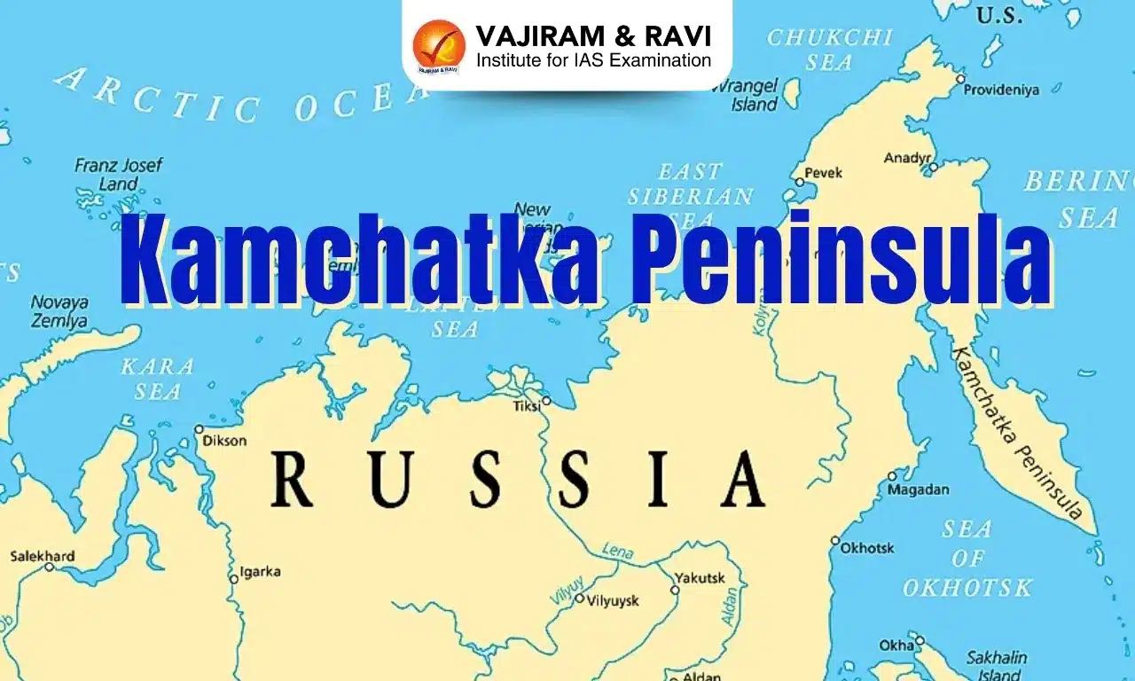
  • Location: It lies in far eastern Russia, between the Sea of Okhotsk on the west and the Pacific Ocean and Bering Sea on the east.
  • It is one of the world’s most concentrated areas of geothermal activity.
  • It contains the “volcanoes of Kamchatka”, a UNESCO World Heritage Site.
  • It is part of the Kamchatka Krai. Kamchatka, also known as a land of fire and ice, sits on the Pacific Ring of Fire and is home to over 150 volcanoes, including 29 active volcanoes.
  • It is one of the largest peninsulas in the world.
  • Climate: It experiences severe, with prolonged, cold, and snowy winters and wet, cool summers.
  • Highest Point: The Klyuchevskaya Sopka in the Eastern Range is the highest point on the Kamchatka Peninsula. 
    • The Kuril island chain runs from the southern tip of the peninsula to a short distance from Japan’s northern Hokkaido Island.

Source: NDTV

Kamchatka Peninsula FAQs

Q1: Where is Kamchatka Peninsula?

Ans: It lies in far eastern Russia, between the Sea of Okhotsk on the west and the Pacific Ocean and Bering Sea on the east.

Q2: What type of climate is found in Kamchatka Peninsula?

Ans: It experiences severe, with prolonged, cold, and snowy winters and wet, cool summers.

Enquire Now