Land reclamation is the process of converting water-covered areas such as seas, rivers, lakes and wetlands into usable land through engineering methods. It supports urban growth, infrastructure development and strategic projects in land-scarce regions. However, if not scientifically planned, it can disrupt ecosystems, increase climate and disaster risks, and threaten coastal and inland environments.
What is Land Reclamation?
Land reclamation is the process of creating new, usable land by converting areas covered by water bodies such as seas, rivers, lakes, marshes and wetlands into dry land through filling, drainage and land stabilisation techniques. According to standard geographical understanding, it involves altering the natural landscape to increase the availability of land for human activities.
- Coastal reclamation is the most common form, where shallow seas, tidal areas and coastal wetlands are converted into land for ports, airports, industries, housing and urban infrastructure.
- Inland reclamation involves converting lakes, marshes, floodplains and other water bodies into usable land, often for agriculture or urban development.
Land Reclamation Methods
Land reclamation methods have evolved with technological advancement, moving from simple filling techniques to modern engineering approaches that ensure land stability and long-term usability.
- Traditional Fill-and-Raise Method: Earlier reclamation involved gradually depositing soil, sediments or rocks over shallow water bodies to raise land levels and create dry land.
- Polder System: A specialised traditional method where land is enclosed using dykes or embankments and then drained to remove water. This method is widely used in the Netherlands.
- Dry Reclamation: A modern extension of the filling approach, where rock, clay or soil is transported and mechanically compacted to raise land elevation. It is suitable where the seabed is relatively stable and was used in early coastal expansion projects such as Mumbai.
- Hydraulic Reclamation: A widely used modern technique in which dredged seabed sediments are mixed with water and pumped into the reclamation site, where they settle to form new land. It is commonly used for large-scale projects due to its efficiency, including reclamation projects in Singapore.
- Ground Stabilisation Techniques: Since reclaimed land often has weak soil conditions, supporting techniques such as sand compaction piles and deep cement mixing are used to improve soil strength, reduce settlement and minimise liquefaction risks.


Why is Land Reclamation Undertaken?
Land reclamation is driven by economic, urban and strategic requirements, especially in land-scarce regions.
- Urban expansion: Coastal cities such as Mumbai, Singapore and Hong Kong use reclamation to create additional space for growing populations.
- Infrastructure development: Reclaimed land supports ports, airports, industrial zones and logistics hubs.
- Trade promotion: Many global ports have expanded through reclamation to handle increasing maritime trade.
- Strategic importance: Countries use artificial islands and reclaimed areas to strengthen maritime presence and geopolitical influence.
- Tourism development: Waterfront projects and luxury real estate developments often depend on reclaimed land.
Global Examples of Land Reclamation
Land reclamation has significantly transformed coastal landscapes across the world.
- China: Created large reclaimed coastal areas mainly for industrial zones and port infrastructure.
- Singapore: Expanded its territory through extensive reclamation due to limited land availability.
- South Korea: Incheon’s coastal reclamation supported industrial and urban development.
- Netherlands: The traditional polder system converted low-lying coastal areas into productive land.
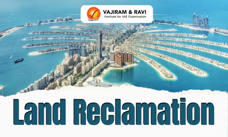
- Dubai: Artificial islands such as Palm Islands demonstrate tourism-oriented reclamation.
Land Reclamation in India
India has used reclamation for urban expansion, ports and strategic infrastructure development.
- Mumbai: The original seven islands were gradually connected through reclamation projects such as the Hornby Vellard project, creating the modern Mumbai landmass.
- Kochi and Kolkata: Reclamation supported port expansion and urban development.
- Urban wetlands: Cities like Bengaluru, Chennai and Mumbai have witnessed conversion of lakes, marshes and floodplains into built-up areas.
Great Nicobar Island Project: A Contemporary Example
The Great Nicobar Island Development Project represents one of India’s largest reclamation-linked infrastructure initiatives. Located in the Andaman and Nicobar Islands near the strategic Six Degree Channel, the project aims to develop a transshipment port, airport, power infrastructure and township.
- The project is linked with India’s Act East Policy and aims to reduce dependence on foreign transshipment hubs such as Singapore and Colombo.
- Land reclamation is proposed for infrastructure components, including the International Container Transshipment Terminal and airport facilities.
The project has raised concerns regarding forest diversion, biodiversity conservation, tribal rights and coastal ecosystem protection. Galathea Bay, known for leatherback turtle nesting and rich marine biodiversity, remains a major ecological concern.
Land Reclamation Regulatory Framework in India
Land reclamation in India is regulated through multiple environmental laws and policies depending on the ecosystem involved.
- Coastal Regulation Zone (CRZ) Framework: Reclamation is restricted in sensitive coastal areas and allowed mainly for projects like ports, harbours and strategic infrastructure.
- Coastal reclamation is regulated under the CRZ Notifications issued under the Environment (Protection) Act, 1986.
- National Coastal Zone Management Authority (NCZMA) and State Coastal Zone Management Authorities (SCZMAs) monitor compliance with coastal regulations.
- Wetlands (Conservation and Management) Rules, 2017: Reclamation of wetlands, lakes and marshes is regulated to protect biodiversity, groundwater recharge and flood management functions.
- Forest Conservation Framework: Reclamation involving forest land requires approval under the Forest (Conservation) Act, 1980 and compliance with the Forest Rights Act, 2006 where tribal and forest-dependent communities are affected.
- Environmental Clearance: Large reclamation projects require prior environmental clearance under the EIA Notification, 2006, along with assessment of ecological impacts and mitigation measures.
- Judicial Oversight: The National Green Tribunal (NGT) ensures enforcement of environmental laws and addresses disputes related to ecological damage.
Land Reclamation Environmental and Geographical Impacts
While land reclamation helps in expanding land availability and supporting economic development, excessive and poorly planned reclamation can disturb ecological systems, alter natural processes and increase vulnerability to climate and disaster risks.
Loss of Coastal Ecosystems:
- Degradation of natural coastal buffers: Reclamation often results in the destruction of mangroves, coral reefs, salt marshes and estuaries that protect coastlines from erosion and storms.
- Decline in biodiversity: Loss of wetlands and coastal habitats affects marine species, fish breeding grounds and the livelihoods of fishing communities.
Increased Coastal Flooding and Climate Vulnerability:
- Higher exposure to climate risks: Many reclaimed areas are low-lying and face increased threats from sea-level rise, storm surges and land subsidence.
- Future flood risks: A large share of recently created coastal land globally is projected to face high flooding risks due to climate change and increasing extreme weather events.
Disturbance of Marine Ecosystems:
- Damage due to sand extraction: Reclamation requires large quantities of sand and sediments, leading to seabed mining and degradation of marine ecosystems.
- Impact on aquatic life: Removal of seabed materials destroys habitats and breeding grounds of marine organisms.
Disruption of Coastal Processes:
- Alteration of sediment movement: Artificial barriers and coastal structures interfere with natural longshore drift and sediment circulation.
- Increased erosion risk: Changes in coastal processes can accelerate erosion in neighbouring areas while causing abnormal sediment accumulation elsewhere.
Geological and Disaster Risks:
- Soil liquefaction: Reclaimed land with poorly compacted, water-saturated soil may lose its strength during earthquakes and behave like a liquid.
- Earthquake vulnerability: Such risks were witnessed during the Kobe Earthquake (1995) and San Francisco Earthquake (1989), where reclaimed areas suffered significant damage.
Urban Environmental Challenges:
- Loss of inland water bodies: Conversion of lakes, marshes and floodplains into urban land reduces groundwater recharge and natural flood storage capacity.
- Urban flooding: Encroachment on wetlands, such as Chennai’s Pallikaranai Marshland and Bengaluru’s lake systems, has contributed to increased flood vulnerability.
- Urban Heat Island effect: Reduction in water bodies and green spaces raises urban temperatures and worsens local climate conditions.
Way Forward: Sustainable Land Reclamation
Future reclamation projects require balancing development needs with ecological sustainability.
- Integrated coastal planning: Develop science-based coastal zone management plans considering climate risks and ecological carrying capacity.
- Nature-based solutions: Promote mangrove restoration, living shorelines and eco-friendly coastal protection instead of excessive hard engineering.
- Sponge city approach: Adopt urban designs that preserve wetlands, improve water absorption and reduce flooding.
- Room for the River approach: Restore floodplains and allow controlled flooding instead of continuous conversion of water spaces.
- Advanced monitoring: Use satellite technology, Geographic Information System (GIS) and Artificial Intelligence for coastal mapping, erosion prediction and impact assessment.
- Strong environmental assessment: Ensure cumulative impact studies, biodiversity assessment and community participation before approving major projects.

 Last updated on Sep, 2026
→ UPSC 2027 Notification will be released on 13 January 2027 at upsconline.nic.in.
→ Asian Games 2026 are being held in Aichi-Nagoya, Japan, from 19 September to 4 October.
→ Check out the latest UPSC Syllabus here.
→ Download UPSC Model Answers for Mains 2026
→ UPSC Mains Question Paper 2026 is out now for Essay & GS Paper 1, 2, 3 & 4.
→ UPSC Calendar 2027 has been released.
→ Enroll in Vajiram & Ravi’s UPSC Mains Test Series 2027 for structured answer writing practice, expert evaluation, and exam-oriented feedback.
→ Join Vajiram & Ravi’s UPSC Mentorship Program 2027 for personalized guidance, strategy planning, and one-to-one support from experienced mentors.
→ Go through the UPSC Mains Previous Year Papers to enhance your preparation.
→ UPSC has released UPSC Toppers List 2025 with the Civil Services final result on its official website.
→ Also check Best UPSC Coaching in India
Land Reclamation FAQs
Q1. What is Land Reclamation?+
Q2. Why is Land Reclamation undertaken?+
Q3. What are the major methods of Land Reclamation?+
Q4. What are the environmental impacts of Land Reclamation?+
Q5. How can Land Reclamation be made sustainable?+
Tags: land reclamation