

Dedicated Freight Corridors, How They Cut Transit Time and Boost Rail Freight

Dedicated Freight Corridors

Dedicated Freight Corridors Latest News

  • Prime Minister Narendra Modi inaugurated the last three sections of the Western Dedicated Freight Corridor in Vadodara, marking the completion of the 1,506-km corridor and taking India's total dedicated freight network to 2,843 km.

About Dedicated Freight Corridors

  • Dedicated Freight Corridors (DFCs) are rail routes built exclusively for goods traffic, separated from the passenger network.
  • India's two busiest trunk routes, Howrah-Delhi on the eastern side and Mumbai-Delhi on the western side, had become severely oversaturated, with line capacity utilisation ranging between 115% and 150%. 
  • This congestion caused freight traffic to decline, since passenger trains are typically given priority over goods movement.
  • Separating freight onto dedicated tracks was intended to restore capacity, improve speeds and reduce transit times.

Origins of the Project

  • The Dedicated Freight Corridor Corporation of India (DFCCIL), a special purpose vehicle, was incorporated in 2006, but early years primarily involved initial approvals, alignment finalization, and prolonged land acquisition.
  • Rapid Execution & Commissioning (2014-2026): The vast majority of major civil engineering, track laying, electrification, and section commissioning occurred during this period.
  • Financing
    • The projects were financed through debt funding from two multilateral sources:
      • World Bank: Rs. 14,900 crore
      • Japan International Cooperation Agency: Rs. 38,722 crore
  • Gross budgetary support accounted for the remaining amount.

The Two Corridors
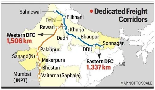
  • Western Dedicated Freight Corridor
    • The WDFC spans 1,506 km, running from Jawaharlal Nehru Port Trust (JNPT) in Navi Mumbai to Dadri in Uttar Pradesh, near Delhi.
    • Traffic on this corridor consists mainly of ISO containers from JNPT and Mumbai Port in Maharashtra, and from Pipavav, Mundra and Kandla ports in Gujarat. These containers are headed for Inland Container Depots (ICDs) in north India, primarily at Tughlakabad in Delhi, Dadri in Uttar Pradesh, Dhandari Kalan in Punjab and Khatuwas in Rajasthan.
    • The corridor is also expected to carry fertilisers, foodgrain, salt, coal, iron, steel and cement.
  • Eastern Dedicated Freight Corridor
    • The EDFC spans 1,337 km, running from Ludhiana in Punjab to Sonnagar in Bihar. It caters mostly to coal and mineral traffic from eastern India.
    • It comprises two distinct segments:
    • An electrified double-line segment of 936 km between Sonnagar and Dadri
    • An electrified single-track segment of 401 km between Ludhiana (Sahnewal) and Khurja
    • The EDFC was fully commissioned in October 2023. Its alignment deliberately takes a detour to bypass densely populated towns including Mirzapur, Allahabad, Kanpur, Etawah, Firozabad, Tundla, Hathras, Aligarh, Hapur, Meerut, Muzaffarnagar, Ambala, Rajpura, Sirhind, Doraha and Sahnewal.

News Summary: Completion of the Western Corridor

  • The three sections inaugurated cover 326 kilometres and were developed at a cost of over Rs. 20,700 crore. These sections lie between Gujarat and Maharashtra:
    • New Sanand (N) to New Makarpura
    • New Umbergaon to New Saphale
    • New Saphale to New JNPT
  • With the last remaining stretch between Vaitarna (Saphale) and JNPT now operational, the WDFC gains direct connectivity to JNPT. 
  • Freight loading on the corridor is expected to increase further as a result.
  • Together, the two corridors now form a 2,843-km dedicated freight network carrying about 426 freight trains daily.

Performance and Impact

  • Speed Gains
    • The most measurable benefit has been in average speeds.
    • Railways data shows the average speed of trains on DFCs was over 50 kmph, roughly double the average speed of freight trains on the non-DFC network. In April and May, recorded speeds were:
      • EDFC: 44.9 kmph and 44.7 kmph
      • WDFC: 53.6 kmph and 52.3 kmph
  • Other Benefits
    • Reduced transit time, since freight trains are no longer held for passenger services.
    • Lower logistics cost per tonne moved.
    • Last-mile connectivity at certain locations, including direct port links.

Why Freight Matters for Railways

  • Freight is the financial backbone of Indian Railways. Freight services account for over 65% of total earnings, and this revenue plays a crucial role in subsidising passenger travel.
  • The scale of the shift being attempted is significant:
    • Current share of freight traffic moved by rail: around 27%
    • Target under the National Rail Plan: 45% by 2030, equivalent to 3,000 million tonnes
    • Highest ever loading achieved: 1,670 million tonnes in 2025-26
  • The Road-Rail Comparison
    • The National Highways running along the DFC routes constitute just 0.5% of India's road network, yet they carry almost 40% of total road freight.
    • This concentration explains why shifting even a portion of that traffic to rail can meaningfully reduce congestion, fuel consumption and emissions.
  • The Third Corridor
    • In the Budget this year, the government announced plans for a third dedicated freight corridor, connecting Dankuni in West Bengal to Surat in Gujarat.
    • The detailed project report is currently being prepared. This corridor would create an east-west link, complementing the existing north-south and north-west alignments.

Significance

  • For logistics costs: India's logistics expenditure as a share of GDP has historically been higher than in comparable economies. Faster, more reliable freight movement addresses one component of that gap.
  • For port connectivity: Direct rail links to JNPT and Gujarat ports reduce dependence on road transport for container movement, improving turnaround times for exporters and importers.
  • For emissions: Rail freight is considerably less carbon-intensive per tonne-kilometre than road transport, making modal shift relevant to India's climate commitments.
  • For passenger services: Freeing capacity on trunk routes creates room for additional passenger trains, which had previously competed with goods traffic for the same tracks.

Source: IE

Dedicated Freight Corridors FAQs

Q1: What is the total length of India's Dedicated Freight Corridors?

Ans: The two corridors together span 2,843 km, 1,506 km on the Western DFC and 1,337 km on the Eastern DFC.

Q2: Which agency implements the DFC project?

Ans: The Dedicated Freight Corridor Corporation of India Limited (DFCCIL), a special purpose vehicle set up for construction, operation and maintenance.

Q3: What is the average speed of trains on the DFCs?

Ans: Over 50 kmph, roughly double the average speed of freight trains on the non-DFC network.

Q4: What is the National Rail Plan target for rail freight share?

Ans: An increase from the current 27% to 45% by 2030, equivalent to 3,000 million tonnes.

Q5: Where will the proposed third freight corridor run?

Ans: From Dankuni in West Bengal to Surat in Gujarat, with the detailed project report currently being prepared.

Equal Earth Map: Why the UN Is Moving Beyond the Mercator Projection

Equal Earth Map

Equal Earth Map Latest News

  • The United Nations General Assembly has adopted a resolution to move away from the 16th-century Mercator map towards the Equal Earth projection, which shows Africa's true size more accurately. 
  • The Togo-led resolution was supported by 164 countries, including India. The United States voted against it and six countries abstained. Since UN resolutions are not binding, it remains to be seen whether governments, organisations and classrooms will actually adopt the new map. 
  • India backed the resolution while drawing a firm line on the depiction of Jammu and Kashmir and Ladakh.

Why No Flat Map Can Be Perfect

  • The Earth is not a perfect sphere. It bulges at the equator because of its spin, is warped by the Moon's gravity, and is further shaped by continents and oceans. 
  • The most accurate representation is therefore a spheroid, a three-dimensional shape formed from a two-dimensional ellipse. 
  • A globe is the best model, but carrying one around is impractical. This is where map projections come in.
    • A projection is the transformation of the Earth's three-dimensional surface onto a two-dimensional map. 
  • Every flat map must distort at least one of four properties:
    • Area: how large a landmass is relative to others
    • Shape: the true outline of a country
    • Distance: the actual space between two points
    • Direction: the correct compass bearing between locations

Types of Map Projections

  • Projections are classified by the property they preserve:
    • Conformal projections preserve angles and local shapes (e.g. Mercator).
    • Equal-area projections preserve relative areas (e.g. Equal Earth).
    • Equidistant projections preserve distance.
    • Compromise projections balance distortions in area, shape, distance and direction without preserving any one exactly (e.g. Robinson, Winkel Tripel).
  • The choice of projection depends entirely on the purpose of the map. Experts caution that one type of map should not be directly compared with another designed for a different purpose.

Origins of the Mercator Projection

  • The Mercator map was introduced in 1569 by Gerardus Mercator, a Flemish geographer from present-day Belgium. 
  • It is a conformal, cylindrical projection, created as if the Earth's surface were unwrapped from a cylinder around the globe.
  • Its greatest strength lies in navigation. It represents rhumb lines (lines of constant compass bearing) as straight lines. A sailor drawing a straight line from Mumbai to Muscat on a Mercator map could hold the same compass direction throughout the voyage. 
  • By the 18th century, this made it the standard projection for navigation. It was also easy to construct, since all parallels and meridians are straight lines.

The Distortion Problem

  • On the Mercator grid, longitudes are evenly spaced, but the gaps between latitudes widen towards the poles. 
  • This is deliberate. To preserve shapes, the stretching of parallels is matched exactly with the stretching of meridians. The result is that landmasses far from the equator appear much larger than they are.
  • The most famous example is Africa, which appears similar in size to Greenland. In reality, Greenland is 14 times smaller and roughly the size of the Democratic Republic of the Congo. Antarctica also appears far larger than its true size.

The Colonial Lens

  • Critics argue that the Mercator projection reflects a Western-centric worldview. It helped Western cartographers map their own towns, cities and roads with ease. 
  • They described the Greenwich-anchored world map as an example of Western cultural hegemony. They argued that the projection served as a political tool during the Scramble for Africa, when European powers partitioned the continent.

The Long Search for a Better Map

  • Several alternatives have emerged over the centuries:
    • Gall-Peters projection: First presented by Scottish clergyman James Gall in 1855, and popularised by German historian Arno Peters in 1973. It preserves area accurately but makes landmasses look stretched or squashed. 
    • Robinson projection (1963): Devised by geographer Arthur H. Robinson to balance size and shape and solve the "Greenland problem". It is a compromise projection with meridians curving gently towards the poles.
    • Winkel Tripel projection (1921): Created by German cartographer Oswald Winkel to reduce distortion across area, distance and direction. In 1998, it replaced the Robinson projection in National Geographic Society maps, followed by schools, textbooks and the World Bank.

The Equal Earth Map

  • Developed in 2018 by an international team of cartographers, Equal Earth is an equal-area projection. 
  • It preserves the relative areas of landmasses while allowing some distortion of shape and distance. Its meridians curve gently towards the poles.
  • Supporters say it corrects the visual diminishing of the Global South, including South Asia, and helps reverse "colonial" perceptions of Africa. 
  • It is best suited for thematic and statistical data, such as population density, climate impacts and resource distribution. For classrooms and research, it offers mathematically accurate depiction of area.

Which Projection to Use

  • Navigation and direction: Conformal projections like Mercator.
  • Thematic and statistical data: Equal-area projections like Equal Earth.
  • General reference and world maps: Compromise projections like Robinson or Winkel Tripel.
  • Polar or single-point studies: Azimuthal or planar projections, which project the Earth onto a flat plane from a central point.
  • Adoption in Practice - The World Bank already uses Winkel Tripel or Equal Earth for static maps and is phasing out Mercator on web maps. Google Maps offers a choice between Mercator and a 3D globe view on desktop, but Mercator remains the default on its mobile app.

Conclusion

  • The UN's adoption of the Equal Earth map is a symbolic step towards a fairer representation of the world. Yet no flat map can be perfect, and every projection serves a specific purpose. 
  • The real shift will depend on whether governments, institutions and classrooms embrace the change and challenge long-held perceptions shaped by Mercator.

Source: IE

Equal Earth Map FAQs

Q1: What is the Equal Earth Map?

Ans: The Equal Earth Map is an equal-area projection that accurately preserves relative landmass areas while allowing some distortion in shape and distance.

Q2: Why has the UN adopted the Equal Earth Map?

Ans: The Equal Earth Map was supported by the UN to encourage a fairer visual representation of global land areas, particularly Africa and the Global South.

Q3: How is the Equal Earth Map different from Mercator?

Ans: The Equal Earth Map preserves relative area, whereas Mercator preserves angles and local shapes but significantly enlarges landmasses located near the poles.

Q4: What are the advantages of the Equal Earth Map?

Ans: The Equal Earth Map is particularly useful for thematic and statistical maps because it provides a mathematically accurate comparison of land areas.

Q5: Is the Equal Earth Map suitable for navigation?

Ans: The Equal Earth Map is not primarily designed for navigation; Mercator remains useful because it represents constant compass-bearing routes as straight lines.

NHRC Probe into Instagram Ads, India’s Online Child Abuse Response

NHRC Probe into Instagram Ads

NHRC Probe into Instagram Ads Latest News

  • The National Human Rights Commission (NHRC) has issued notices to the Ministry of Electronics and Information Technology (MeitY), the Ministry of Information and Broadcasting (MIB), and the Delhi Police over paid Instagram advertisements that allegedly directed users to Telegram channels offering child sexual abuse material (CSAM). 
  • The Commission has sought an Action Taken Report within two weeks. The notice flagged that these advertisements had passed Meta's review systems and stayed online until they were brought to the company's attention. 
  • The case exposes a larger problem: India receives a huge volume of alerts about online child abuse, but only a small fraction leads to police action.

Two Questions Raised by the NHRC

  • The NHRC's order raises two key issues:
    • Compliance with POCSO reporting duties: Whether statutory reporting obligations under the Protection of Children from Sexual Offences (POCSO) Act, 2012 were followed.
    • Intermediary status of AI-driven platforms: Whether platforms whose AI systems actively shape content can still claim the legal protections available to intermediaries.

The Mandatory Reporting Obligation

  • Section 19 of the POCSO Act requires any person who apprehends that an offence is likely to be committed, or knows that one has been committed, to report it to the Special Juvenile Police or the local police. 
  • The NHRC has asked Meta whether the alleged offences were reported and, if not, to identify who was responsible for compliance. 
  • The Commission stressed that this legal duty cannot be replaced by internal correspondence, grievance redressal or regulatory engagement.

Are AI-Powered Platforms Still Intermediaries?

  • A supplementary representation before the Commission argued that Meta's AI tools now do far more than host third-party content. Its systems generate captions, recommend posting schedules, optimise engagement and assist monetisation.
  • The NHRC called this a "significant regulatory question". It has asked MIB to examine whether such functions are consistent with intermediary status or whether they resemble the role of a publisher of online curated content under the IT Rules, 2021. 
  • The core issue is whether the law adequately distinguishes mere hosting of third-party content from substantive platform involvement in generating, curating, recommending, amplifying or monetising it.

Understanding CyberTipline Reports

  • India received around 1.9 million CyberTipline reports in 2025. 
  • These are alerts generated when tech platforms detect suspected child sexual exploitation and abuse material (CSEAM). 
  • The reporting chain works as follows:
    • Tech platforms detect suspected material and report it to the National Centre for Missing and Exploited Children (NCMEC) in the United States, which runs the CyberTipline.
    • Reports linked to India are forwarded to Indian authorities.
    • The National Crime Records Bureau (NCRB) and the Indian Cybercrime Coordination Centre (I4C), both under the Union Ministry of Home Affairs, process these reports.
    • Reports are then assigned to state and district authorities. In Delhi, the Intelligence Fusion and Strategic Operations (IFSO) unit receives them, verifies the district, and forwards them to the relevant police station.
  • These reports cover abuse imagery, attempts to distribute such material, online grooming, sextortion, trafficking-related content and accounts suspected of storing CSAM.

From Report to FIR: The Verification Funnel

  • Before an FIR is registered, authorities conduct preliminary verification. Investigators use account details, IP logs, linked email addresses, phone numbers, account creation records and digital hash values to identify the jurisdiction from which content was uploaded.
  • A hash value acts as a digital fingerprint of a file. Investigators compare the hash of recovered material with the hash in the CyberTipline report to confirm both refer to the same content.
  • Not every report progresses. Reports vary widely in quality. Some support immediate action, while others need further verification. 
  • An FIR is registered when the material prima facie appears to depict child sexual abuse. A recurring difficulty is verifying the victim's age. Poor image quality or blurred visuals can prevent police from proceeding.
  • NCRB's Crime in India 2024 report shows how much survives this funnel. 
  • Of 1,238 cybercrime cases registered against children under the IT Act that year, 1,099, or nearly nine in ten, involved publishing or transmitting sexually explicit material depicting children.

Investigation and Trial

  • Once an FIR is registered, investigators identify the person behind the account by obtaining subscriber information, tracing IP addresses, identifying internet service providers and seizing devices for forensic examination. 
  • The chain of custody is documented through certificates under Section 63 of the Bharatiya Sakshya Adhiniyam, 2023.
  • Such cases are tried before POCSO Special Courts. Under Section 28(3) of the POCSO Act, these courts have jurisdiction over offences under Section 67B of the IT Act. 
  • Convictions depend heavily on digital evidence. 

Structural Limitations

  • A CyberTipline report usually identifies where material was found, not where it originated. Establishing origin requires separate investigation.
  • Reports pass through multiple agencies before reaching a police station, causing delays even when the child, offender and platform are all in India.
  • Offenders increasingly use encrypted platforms and AI-generated content, making traditional detection methods like hash matching less effective.
  • Experts argue that equipping agencies is not a one-time fix, as the crime keeps changing shape. Law enforcement must evolve at the same pace.

Conclusion

  • The NHRC probe highlights two urgent gaps: weak enforcement of mandatory reporting under POCSO and outdated intermediary rules for AI-driven platforms. 
  • India's system converts only a fraction of abuse alerts into prosecutions because of multi-layered routing, verification hurdles and evolving technology. 
  • Faster reporting chains, clearer platform accountability and continuous capacity building are essential to protect children online.

Source: IE

NHRC Probe into Instagram Ads FAQs

Q1: What is the NHRC probe into Instagram ads about?

Ans: The NHRC probe into Instagram ads examines advertisements allegedly directing users to Telegram channels offering child sexual abuse material despite Meta’s review systems.

Q2: Why did the NHRC initiate a probe into Instagram ads?

Ans: The NHRC probe into Instagram ads followed allegations that paid advertisements linked users to child sexual abuse material and remained online until reported.

Q3: What does POCSO require regarding child abuse material?

Ans: The NHRC probe into Instagram ads highlights Section 19 of POCSO, which requires suspected offences involving children to be reported to police.

Q4: What are CyberTipline reports in India?

Ans: The NHRC probe into Instagram ads highlights CyberTipline reports, which alert Indian authorities about suspected child exploitation material detected by technology platforms.

Q5: What are the major challenges identified by the NHRC probe?

Ans: The NHRC probe into Instagram ads identifies delayed reporting chains, verification hurdles, unclear platform accountability, encryption and evolving AI-generated child abuse material.

Enquire Now

