Scarborough Shoal

Scarborough Shoal

Scarborough Shoal Latest News

China deployed two long-range H-6 bombers around the Scarborough Shoal recently, in Beijing's latest move to assert sovereignty over the hotly disputed atoll in the South China Sea.

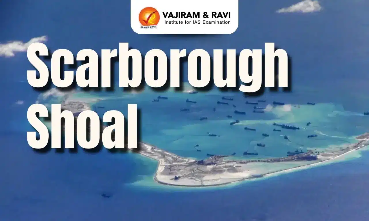
About Scarborough Shoal

  • The Scarborough Shoal (also known in English as the Scarborough Reef) is an oceanic coral atoll that developed on top of a seamount into a triangle shape in the eastern part of the South China Sea.
  • It is located some 220 kilometers west of the Philippines’ Island of Luzon.
  • It is the largest atoll in the South China Sea, submerged at high tide with few rocks above sea level.
  • This atoll extends 18 km along its northwest-southeast axis and reaches 10 km along its northeast-southwest axis.
  • The deep waters around the shoal make it a productive fishing area, rich in marine life, and the lagoon also contains many commercially valuable shellfish and sea cucumbers.
  • The shoal is the source of an ongoing and, so far, unresolved dispute between the People’s Republic of China and the Philippines, with both countries claiming that the shoal lies within their territory and saying they have exclusive rights to access its waters.
  • There are no structures built on Scarborough Shoal, but the feature is effectively controlled by China, which has maintained a constant coast guard presence at the feature since 2012.
  • China, which now refers to the shoal as Huangyan Island, makes a historical claim to the area, stating that they can trace their ownership of the area back to the Yuan Dynasty of the 1200s.
  • The Philippines claim the area on the basis of geography, as it is much closer to the Philippines’ main island of Luzon, which contains the capital, Manila, but lies over 500 miles from China.
  • It is considered within the Philippines’ 200-nautical mile exclusive economic zone, based on the 1982 United Nations Convention on the Law of the Sea (UNCLOS). 

Scarborough Shoal FAQs

Q1. What country owns Scarborough Shoal?

Ans. Scarborough Shoal is a disputed territory in the South China Sea, claimed by both China and the Philippines.

Q2. Where is Scarborough Shoal located?

Ans. South China Sea

Q3. How large is Scarborough Shoal?

Ans. 18 km by 10 km

Source: NDTV

Greenland

Greenland

Greenland Latest News

US Vice President JD Vance landed in Greenland amid renewed calls from President Donald Trump to assert control over the territory.

About Greenland

  • Geographical location: North Atlantic Ocean, between North America and Europe
  • Capital: Nuuk
  • Highest point: Gunnbjørn’s Fjeld
  • Climate: Arctic climate, with temperatures ranging from -50°C in winter to 10–15°C in summer
  • Natural resources: Minerals, oil, gas, and rare earth elements
  • Strategic importance: Pituffik Space Base is crucial for US missile defense systems
  • Historical and Political background: Greenland is an autonomous territory of Denmark but holds strategic significance due to its location between North America and Europe.
    • The island was a Danish colony until 1979, when it gained home rule; in 2009, it achieved self-governing status, but foreign policy, defense, and monetary matters remain under Denmark’s control.

US Interests in Greenland

  • Strategic military location: The Pituffik Space Base is crucial for the US ballistic missile warning system due to its position along the shortest route between North America and Europe.
    • The 1951 Agreement allows the US access to the base but requires prior notification to Greenland and Denmark.
  • Natural resources and economic interests: Greenland is rich in minerals, oil, and natural gas, including rare earth minerals, which are vital for US economic and technological interests.
    • Despite this, most mining companies operating in Greenland are Australian, Canadian, or British.
  • US attempts to acquire Greenland: In 2019, Trump proposed to buy Greenland from Denmark, but the offer was rejected.
    • In 2025, Trump reaffirmed his belief that the US should control Greenland, arguing it is strategically and economically necessary.

Greenland FAQs

Q1. Where is Greenland located?
Ans. Greenland is the world’s largest island, located in the Arctic region, between the North Atlantic and Arctic Oceans, and is an autonomous territory of Denmark.

Q2. Why is Greenland important for climate change studies?
Ans. Greenland’s ice sheet is melting rapidly due to global warming, contributing to rising sea levels and affecting global climate patterns.

Q3. What natural resources are found in Greenland?
Ans. Greenland is rich in rare earth minerals, uranium, iron ore, oil, and gas, making it strategically important for global energy and technology sectors.

Source: IE

BIMSTEC

BIMSTEC

BIMSTEC Latest News

The Indian Prime Minister will visit Bangkok, Thailand, from April 3-4, 2025, to participate in the 6th BIMSTEC Summit and hold discussions with the Thai PM.

What is BIMSTEC?

  • BIMSTEC (Bay of Bengal Initiative for Multi-Sectoral Technical and Economic Cooperation) is a regional multilateral organization that connects South Asia and Southeast Asia.
  • Established through the Bangkok Declaration in 1997, it promotes economic and social progress in the region.
  • Member Countries
    • South Asia: Bangladesh, Bhutan, India, Nepal, Sri Lanka.
    • Southeast Asia: Myanmar, Thailand.
  • Key Features
    • Bridges South and Southeast Asia, linking the Himalayan region with the Bay of Bengal.
    • Focuses on economic growth, trade, technology, energy, security, and connectivity.
    • Acts as an alternative to SAARC for regional cooperation.

Evolution of BIMSTEC

  • Initially formed as ‘BIST-EC’ (Bangladesh, India, Sri Lanka, and Thailand Economic Cooperation).
  • Renamed ‘BIMST-EC’ after Myanmar joined in 1997.
  • In 2004, Nepal and Bhutan joined, leading to the current name: BIMSTEC.

India’s Role in BIMSTEC

  • Leading Initiatives in trade, security, maritime cooperation, and climate action.
  • Key proponent of BIMSTEC Free Trade Agreement to enhance regional trade integration.
  • Advocates for stronger physical and digital connectivity between BIMSTEC nations.

India’s Strategic Vision in BIMSTEC

  • Neighbourhood First Policy: Prioritising economic and security ties with South Asian neighbors.
  • Act East Policy: Strengthening engagements with ASEAN and Southeast Asia.
  • MAHASAGAR Vision: Enhancing India’s role in global maritime security and economic growth.
  • This visit marks India’s continued commitment to its ‘Neighbourhood First’ and ‘Act East’ policies, as well as its MAHASAGAR Vision (Mutual and Holistic Advancement for Security and Growth Across Regions).

BIMSTEC FAQs

Q1. What is BIMSTEC?
Ans. BIMSTEC is a regional organisation comprising Bangladesh, India, Myanmar, Sri Lanka, Thailand, Nepal, and Bhutan, aimed at economic and technical cooperation.

Q2. When was BIMSTEC established?
Ans. BIMSTEC was established on June 6, 1997, through the Bangkok Declaration.

Q3. What are the key sectors of BIMSTEC cooperation?
Ans. BIMSTEC focuses on 14 key sectors, including trade, connectivity, energy, counterterrorism, climate change, and technology.

Q4. Where is the BIMSTEC Secretariat located?
Ans. The BIMSTEC Secretariat is headquartered in Dhaka, Bangladesh.

Source: IE

Teesta River

Teesta River

Teesta River Latest News

Recently, Bangladesh welcomed Chinese participation in the Teesta River Comprehensive Management and Restoration Project.

About the Teesta River

  • Geographical significance: The Teesta River is a major transboundary river flowing through India and Bangladesh, serving as a crucial water resource for both nations.
  • Origin: The river originates from the Tso Lhamo Lake at an elevation of approximately 5,280 meters in North Sikkim, India. 
    • Other sources cited include the Pahunri Glacier, Khangse Glacier, and Chho Lhamo Lake.
  • Course: The Teesta flows southward through the Sikkim Himalayas, passing towns like Rangpo, and then through West Bengal before entering Bangladesh, where it joins the Brahmaputra River (known as the Jamuna River in Bangladesh). 
    • Historically, the Teesta was a major tributary of the Ganges River.
  • Length and basin area: The river spans approximately 414 kilometers, with a drainage basin covering around 12,540 square kilometers. Notably, 83% of the basin lies in India, while 17% is in Bangladesh.
  • Tributaries:
    • Left-bank tributaries: Lachung Chhu, Chakung Chhu, Dik Chhu, Rani Khola, and Rangpo Chhu.
    • Right-bank tributaries: Zemu Chhu, Rangyong Chhu, and Rangit River.
  • Hydroelectric projects and barrages:
    • In India:
      • Teesta-V Dam: 510 MW, located in Gangtok district, Sikkim.
      • Teesta-III Dam: 1,200 MW, situated in Mangan district, Sikkim.
      • Teesta Low Dam III & IV: 132 MW and 160 MW respectively, both in Kalimpong district, West Bengal.
      • Gajoldoba Barrage: Primarily for irrigation purposes in West Bengal.
    • In Bangladesh:
      • Duani Barrage: Used mainly for irrigation.
      • Barakhata Teesta Barrage: Another significant irrigation infrastructure.

Teesta River FAQs

Q1. Where does the Teesta River originate?
Ans. The Teesta River originates from the Tso Lhamo Lake in Sikkim and flows through West Bengal and Bangladesh before merging with the Brahmaputra.

Q2. What is the Teesta River water-sharing dispute?
Ans. India and Bangladesh have an ongoing dispute over Teesta's water distribution, with Bangladesh seeking a fair share, while West Bengal expresses concerns over water availability.

Q3. What is the ecological significance of the Teesta River?
Ans. The river supports rich biodiversity, agriculture, and hydropower projects, but glacial retreat and human activities threaten its flow.

Source: TH

Tadoba-Andhari Tiger Reserve

Tadoba-Andhari Tiger Reserve

Tadoba-Andhari Tiger Reserve Latest News

Maharashtra’s Tadoba-Andhari Tiger Reserve recently introduced new tourist-friendly reforms, including a fast-track safari entry system, relaxed rules for late-night arrivals, and improved full-day safaris.

About Tadoba-Andhari Tiger Reserve

  • Location: It is located in the Chandrapur district in Maharashtra.
  • It is the largest and oldest Tiger Reserve of Maharashtra. 
  • The origin of the name "Tadoba" lies with the name of the god "Tadoba" or "Taru",worshipped by the tribes that live in the dense forests of the Tadoba and Andhari regions. "Andhari" refers to the Andhari River that meanders through the forest.
  • The total area of the reserve is 625.4 sq. km. This includes Tadoba National Park, covering 116.55 sq. km, and Andhari Wildlife Sanctuary, covering 508.85 sq. km.
  • Corridor: The reserve has corridor linkages with Nagzira-Navegaon and Pench Tiger Reserves within the State.
  • Habitat:
    • Biogeographically, the reserve falls in the Central Plateau province of the Deccan Peninsula.
    • The habitat has undulating topography in the north and is rich in biodiversity.
  • Vegetation: Southern Tropical Dry Deciduous
  • There are two lakes and one waterway in the reserve, Tadoba Lake, Kolsa Lake, and the Tadoba River.
  • Flora:
    • It is blessed with thick forests covered with teak trees and other vegetation such as crocodile bark, salai, tendu, karaya gum, and mahua madhuca.
    • The reserve is adorned with patches of grass and bamboo shrubberies.
  • Fauna:
    • The notable faunal species include the tiger, leopard, sloth bear, wild dog, gaur, chital, and sambar.
    • As many as 280 species of birds are found, apart from reptiles (54 species), amphibians (11 species), and fishes (84 species).

Tadoba-Andhari Tiger Reserve FAQs

Q1. Where is Tadoba-Andhari Tiger Reserve located?

Ans. Maharashtra

Q2. Which two protected areas make up Tadoba-Andhari Tiger Reserve?

Ans. Tadoba National Park and Andhari Wildlife Sanctuary

Q3. In which biogeographical province does Tadoba-Andhari Tiger Reserve fall?

Ans. Deccan Peninsula – Central Plateau

Source: OLT

Enquire Now