Russia Deploys Geran-5 K5-K Jet-Powered Attack Drones Against Ukrainian Cities

Geran-5

Geran-5 Latest News

Russia began using a variant of its Geran-5 drone known as the K5-K to attack Ukrainian cities, the GUR, Kyiv's military intelligence agency, said recently.

About Geran-5

  • It is a Russian jet-powered one-way attack drone built in the shape of a small cruise missile.  
  • Features:
    • Unlike the propeller-driven Geran-2 drones commonly used in  Russia’s Shahed-style attacks, the Geran-5 is powered by a  turbojet engine and has a conventional aircraft configuration.
    • It is 6.5 meters long, has a wingspan of 3.2 meters and a maximum takeoff weight of up to 850 kilograms. 
    • It is equipped with a warhead weighing about 90 kilograms.
    • It has a cruising speed of 450–600 km/h, a range of about 950 kilometers and can reach an altitude of up to 6 kilometers. 
    • It features an autonomous optical navigation system and a modified fuselage design. 
    • It is equipped with an electro-optical correction system that allows it to navigate using images of the ground surface.

News: BUS

Geran-5 FAQs

Q1: What is Geran-5?

Ans: It is a Russian jet-powered, one-way attack drone designed in the shape of a small cruise missile.

Q2: What type of engine powers the Geran-5 drone?

Ans: A turbojet engine.

Q3: What is the operational range of the Geran-5 drone?

Ans: Approximately 950 km.

Q4: What type of navigation system is used by the Geran-5 drone?

Ans: An autonomous optical navigation system.

Scientists Discover Five New Horned Frog Species in Arunachal Pradesh, Including India’s First Snail-Eating Frog

New Frog Species

New Frog Species Latest News

Recently, a team of Indian and American scientists has discovered five new species of diminutive horned frogs in Arunachal Pradesh.

About New Frog Species  

  • These new five frog species belong to genus Jingophrys, commonly known as diminutive horned frogs.
  • All five new species were discovered in Arunachal Pradesh.
  • Jingophrys taniitatii
    • It is also known as the Tanii Horned Frog, honours the Tanii tribe of the Ziro Valley region and incorporates the Apatani word ‘tatii’, meaning frogs and toads.
  • Jingophrys Tanogogo
    • It is also known as the Snail-eating Horned Frog.
    • The species is the first snail-eating frog known from India and represents the first report of snail-eating behaviour in the frog family Megophryidae.
    • The word ‘tanogogo’ for snails has also been adopted from the Apatani tribal language that is spoken in the region.
  • Jingophrys siangensis
    • It is known as Siang Horned Frog which is named after the Siang region,
    • Other two frog species: Jingophrys hrdy (Hrdy’s Horned Frog) and Jingophrys wularsoni (WuLarson’s Horned Frog) were named after anthropologist Sarah Blaffer Hrdy, medical professor Daniel Bruce Hrdy, and herpetologists.

Source: TH

New Frog Species FAQs

Q1: Where was Snail-eating Horned Frog was discovered?

Ans: Arunachal Pradesh

Q2: Jingophrys taniitatii was named after which tribes ?

Ans: Tanii tribe of the Ziro Valley region

Three Butterfly Species Recorded for First Time in Kerala’s Silent Valley National Park

Silent Valley National Park

Silent Valley National Park Latest News

Three butterfly species — Branded Royal, Extra Lascar and Orange-spotted Grass Jewel — were recorded for the first time in Silent Valley National Park during a three-day butterfly survey that concluded recently. 

About Silent Valley National Park

  • It is located in the heart of the Western Ghats in the Palakkad District of Kerala.
  • Spanning an area of approximately 237.52 sq.km., this national park is part of the Nilgiri Biosphere Reserve and is one of the last undisturbed tracts of tropical rainforest in India.  
  • It is said to be "silent" because of the absence of the cicadas, a type of insect that produces a loud buzzing sound in many forests. 
  • Kunthipuzha, known as the Silent River of India, flows quietly through the park. 
  • Tribal Communities: Kurumba, Muduga, Irula, and Kattu Naiken.
  • Flora: 
    • It is home to over 1,000 species of flowering plants, 108 species of orchids, and several rare and endangered plants. 
    • Plants of high medicinal value as well as the towering Culinea trees are also found here. 
  • Fauna: 
    • The park is famous for its population of lion-tailed macaques, an endangered primate species that is endemic to the Western Ghats. 
    • Other notable mammals include the Nilgiri langur, Malabar giant squirrel, Indian elephant, tiger, leopard, and gaur (Indian bison). 
    • The park is also a paradise for bird watchers, with over 200 species of birds, including the great Indian hornbill, Nilgiri wood pigeon, and several species of eagles and owls.

News: TOI

Silent Valley National Park FAQs

Q1: Where is Silent Valley National Park located?

Ans: In the Western Ghats of Palakkad district, Kerala.

Q2: Which biosphere reserve is Silent Valley National Park part of?

Ans: Nilgiri Biosphere Reserve.

Q3: Which river flows through Silent Valley National Park?

Ans: Kunthipuzha River, also known as the Silent River of India.

Q4: Which endangered primate is Silent Valley National Park particularly famous for?

Ans: Lion-tailed macaque.

Canary Islands Bus Crash: One Dead, 27 Injured After Tourist Bus Falls into Ravine

Canary Islands

Canary Islands Latest News

Spain’s coastguard rescued 1,488 migrants in 14 boats off the Canary Islands recently, the highest one-day total since 2020, with most landing on the small island of El Hierro.

About Canary Islands

  • The Canary Islands are an archipelago located off the northwest coast of Africa in the Macaronesia region of the North Atlantic Ocean.
  • Geographically, the archipelago is part of continental Africa, but politically and economically it is part of Europe.
  • The archipelago is a Spanish territory and is its southernmost autonomous community. 
  • It is approximately 100 km from Morocco and southwest of Spain.
  • It is Macaronesia’s largest and most populated archipelago. 
  • The archipelago comprises seven major islands and numerous other minor islands or islets, divided into two groups.
    • The western group consists of La Palma, Tenerife, La Gomera, Gran Canaria, and Ferro. This group is made up of mountain peaks rising directly from the deep seabed. 
    • The eastern island group comprises Fuerteventura, Lanzarote, and six islets (the Chinijo Archipelago) that all sit on an underwater plateau, the Canary Ridge. 
  • Tenerife is the largest island, spanning 2,034 sq.km. It is the second-largest island in Spain and also Spain’s most populated island.
  • The Canary Islands’ capital, Santa Cruz de Tenerife, is located on the island. Tenerife also hosts Teide, Spain’s highest point.
  • The Canary Islands formed millions of years ago through volcanic eruption, and some of the volcanoes are still active. 
  • The archipelago is the only Spanish region where a volcanic eruption has taken place in the modern era.
  • Most beaches along the Canaries have black sand due to their volcanic composition.

News: FP

Canary Islands FAQs

Q1: Where are the Canary Islands located?

Ans: The Canary Islands are an archipelago located off the northwest coast of Africa in the Macaronesia region of the North Atlantic Ocean.

Q2: Which country does the Canary Islands belong to?

Ans: Spain.

Q3: Which is the largest island in the Canary Islands archipelago?

Ans: Tenerife.

Q4: How were the Canary Islands formed?

Ans: Through volcanic eruptions millions of years ago.

Ekalavya Model Residential Schools to Introduce Amazon Future Engineer Programme for Tribal Students

Eklavya Model Residential Schools

Eklavya Model Residential School Latest News

Recently, the Prime Minister of India inaugurated four newly constructed Eklavya Model Residential Schools (EMRS) across Tripura on the occasion of the 151st birth anniversary of tribal freedom fighter Bhagwan Birsa Munda.

About Eklavya Model Residential School

  • It is a flagship intervention of the Ministry of Tribal Affairs launched in 1998.
  • It aims to provide quality residential education to Scheduled Tribes students from Class 6th to 12th in remote areas to enable them to access the best opportunities in education and to bring them at par with the general population.
  • The programme was revamped during the year 2018-19 to expand the geographical outreach and enhance the quality of facilities.
  • EMRSs to be set up in every block with more than 50% ST population and at least 20,000 tribal persons. 
  • Governance: The National Education Society for Tribal Students (NESTS), an autonomous organization, has been set up under the Ministry of Tribal Affairs to establish and manage EMRS across the country.

Features of Eklavya Model Residential Schools

  • EMRSs are co-educational residential schools from Class VI to XII.
  • Eklavya schools will be on par with Navodaya Vidyalayas and will have special facilities for preserving local art and culture besides providing training in sports and skill development.
  • Infrastructure: The school infrastructure will include classroom, administrative block, hostels, playground.
  • CBSE curriculum is followed in these schools, and education is completely free.
  • Each school has a capacity of 480 students with an equal number of seats for boys and girls.
  • Non-ST students can be admitted in these schools on seats up to 10% of the total seats. And also reservation of 20% of seats under sports quota for deserving ST students who have excelled in the field of sports.

Source: News On Air

Eklavya Model Residential School FAQs

Q1: What is Eklavya Model Residential School ?

Ans: It is a flagship intervention of the Ministry of Tribal Affairs launched in 1998.

Q2: Which organisationestablish and manage EMRS across the country?

Ans: National Education Society for Tribal Students (NESTS),

Yamuna River Cleaning Drive Launched with Four-Pronged Strategy to Restore River in 3 Years

Yamuna River

Yamuna River Latest News

Despite the political slugfest over the Yamuna River recently, official data show that the river’s Delhi stretch remains heavily polluted for most of the year, with water quality improving during the monsoon, when floodwaters flush out pollutants.

About Yamuna River

  • It is the major tributary of the Ganges River. 
  • Course:
    • It rises in the high Himalaya, in the Yamunotri Glacier in Uttarakhand, at the height of 4,421 meters.
    • It flows in a southerly direction swiftly through the Himalayan foothills and, exiting Uttarakhand, onto the Indo-Gangetic Plain, along the border between Uttar Pradesh and Haryana state to the west. 
    • The Eastern and Western Yamuna canals are fed from the river at that point.
    • The Yamuna then passes Delhi, where it feeds the Agra Canal.
    • South of Delhi, and now wholly within Uttar Pradesh, it turns southeastward.
    • Near Prayagraj, after a course of about 1,376 km, the Yamuna joins the Ganges River. 
    • The confluence of the two rivers is an especially sacred place to Hindus and is the site of annual festivals as well as the Kumbh Mela, which is held every 12 years.
  • Tributaries:
    • Near Dehradun, the capital city of Uttarakhand, the Yamuna is joined by its biggest tributary, the Tons River.
    • The Chambal River is Yamuna’s biggest tributary on the right.
    • Other important tributaries of the Yamuna include the Hindon, Sarda, and Giri rivers on the right and the Betwa and Sindh on the left.
  • The Yamuna River flows near many important cities and landmarks, each adding to its cultural importance:
    • Yamunotri
    • Delhi
    • Agra
    • Mathura
    • Haridwar
    • Vrindavan
    • Prayagraj
    • Etawah
    • Noida
    • Faridabad
    • Hathras

News: TH

Yamuna River FAQs

Q1: Where does the Yamuna River originate?

Ans: From the Yamunotri Glacier in Uttarakhand, in the high Himalayas.

Q2: What is the approximate total length of the Yamuna River?

Ans: Approximately 1,376 km.

Q3: Which is the biggest tributary of the Yamuna River?

Ans: The Tons River.

Q4: Which city is located at the confluence of the Yamuna and Ganges rivers?

Ans: Prayagraj.

Minister Faces Criticism After Video Shows Him Pursuing Tiger in Mudumalai Tiger Reserve

Mudumalai Tiger Reserve

Mudumalai Tiger Reserve  Latest News

Recently, a state minister faced flak after a video showing him pursuing a tiger in the Mudumalai Tiger Reserve (MTR) was posted on social media. 

About Mudumalai Tiger Reserve

  • Location: It is located in the Nilgiris District of Tamil Nadu.
  • It is at the tri–junction of three states, viz, Karnataka, Kerala, and Tamil Nadu.
  • It is part of the Nilgiris Biosphere Reserve, the first biosphere reserve in India.
  • It has a common boundary with Wayanad Wildlife Sanctuary (Kerala) on the west, Bandipur Tiger Reserve (Karnataka) on the north.
  • Terrain: The terrain is undulating, with the elevation ranging from 960m to 1266m.
  • Vegetation: A variety of habitats ranging from tropical evergreen forest, moist deciduous forest, moist teak forest, dry teak forest, secondary grasslands, and swamps are found here.
  • River: The Moyar River runs through the reserve.
  • Flora: It has tall grasses, commonly referred to as “Elephant Grass”, bamboo of the giant variety, and valuable timber species like Teak, Rosewood, etc.
    • It has wild relatives of cultivated plants, viz. wild rice, ginger, turmeric, cinnamon, etc.
  • Fauna: It includes elephant, gaur, sambar, four-homed antelope, spotted deer, barking deer, blackbuck, wild pig, mouse deer, and predators like tigers, leopards, and wild dogs

Source: TH

Mudumalai Tiger Reserve FAQs

Q1: Where is Mudumalai Tiger Reserve located?

Ans: It is located in the Nilgiris District of Tamil Nadu.

Q2: Mudumalai Tiger Reserve shares border with which Wildlife Sanctuary?

Ans: It has a common boundary with Wayanad Wildlife Sanctuary (Kerala).

Government Raises Lakhpati Didi Initiative Target to 6 Crore Women by March 2029

Lakhpati Didi Initiative

Lakhpati Didi Initiative Latest News

Recently, it was observed that, as of June 2026 Lakhpati Didi Initiative has enabled 3.76 crore Lakhpati Didis, with a target of six crore by March 2029. 

About Lakhpati Didi Initiative     

  • It is a flagship effort to strengthen women's economic participation in rural India.
  • It aims to improve household incomes through sustainable livelihood opportunities and enterprise development.
  • The government announced this initiative on 15 August 2023.
  • Target
    • It initially targeted two crore women from Self-Help Group (SHG) households. The target was subsequently increased to three crore in February 2024.
    • The initiative aims to create six crore Lakhpati Didis by March 2029. This target was envisioned in February 2026.
  • The initiative builds on the institutional network of the Deendayal Antyodaya Yojana-National Rural Livelihoods Mission (DAY-NRLM).
  • Objective: To encourage women to start micro-enterprises within their villages.
  • Lakhpati Didi Strategy
    • Deepen, Strengthen and Expand Livelihood options : The households will be facilitated and enabled to take up diversified income-generating activities.
    • Capacity Building: A Cascade Training Strategy is adopted to enable training and handholding of Potential Lakhpati Didis (SHG members) from across all States and Union Territories in India.
  • Financial Assistance:  DAY-NRLM serves as a catalyst, facilitating financial assistance and providing a platform for these women to thrive.
  • Nodal Ministry: Ministry of Rural Development.

Source: PIB

Lakhpati Didi Initiative FAQs

Q1: What is Lakhpati Didi Initiative ?

Ans: It is a flagship effort to strengthen women's economic participation in rural India.

Q2: When was Lakhpati Didi Initiative launched?

Ans: It was launched on 15 August 2023.

India and Egypt Hold 7th Joint Trade Committee Meeting to Strengthen Bilateral Economic Ties

Egypt

Egypt Latest News

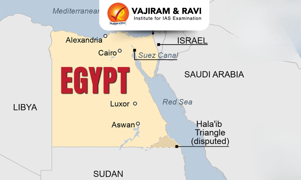
Recently, India and Egypt held a ministerial-level 7th joint trade committee meeting to strengthen bilateral economic ties. 

About Egypt

  • Location: It is located in the northeast corner of Africa to the southwest corner of Asia.
  • The Sinai Peninsula of Egypt acts as the land bridge between Africa and Asia continents.
  • Bordering Countries: It has land borders with Sudan (south), Libya (west), Israel and the Gaza Strip (northeast).
  • Water Bodies: It has a coastline on the Mediterranean Sea (North) while the Red Sea and Gulf of Aqaba border it to the east.
  • Capital City:  Cairo

Geographical Features of Egypt

  • Terrain: Its topography is marked by a striking contrast between its arid desert regions and the fertile Nile River Valley.
  • Climate: It has a tropical climate and has high temperatures throughout the year. 
  • Rivers: The Nile River, the longest river in the world, flows from south to north through Egypt.
  • Highest Peak: Egypt’s highest point Mount Catherine reaching 2,642 meters (8,668 feet) above sea level, 
  • Natural Resources: Egypt’s natural resources include petroleum, natural gas, phosphates, and iron ore.

Source: PIB

Egypt FAQs

Q1: What is the capital city of Egypt?

Ans: Cairo

Q2: Where is Egypt located?

Ans: It is located in the northeast corner of Africa to the southwest corner of Asia.

First GPS-Tracked Bar-Headed Goose Reveals Migration Route and Flight Patterns in Eastern India

Bar-Headed Goose

Bar-Headed Goose Latest News

The bar-headed goose, famed for flying over the Himalayas and surviving at altitudes where oxygen levels are dangerously low, has been spotted at Nandur Madhmeshwar Wildlife Sanctuary after a gap of eight to 10 years.

About Bar-Headed Goose

  • It is a migratory bird species which is known to be one of the highest-flying birds in the world.
  • Scientific Name: Anser indicus 

Bar-Headed Goose Habitat and Distribution 

  • It breeds in Central Asia in colonies of thousands near mountain lakes and winters in South Asia, as far south as peninsular India. 
  • They reside near water bodies, preferring high-altitude lakes during the breeding season and freshwater lakes, rivers, and streams in their wintering habitats. 
  • It can fly at altitudes of 25,000 feet, while migrating over the Himalayas, where oxygen and temperature levels are extremely low.

Bar-Headed Goose Features

  • This species is gray and white with two horseshoe-shaped, brownish-black bars on the back of its white head. 
  • The body is gray overall, and the bill and legs are pink, orange, or yellow. 
  • Although male and female birds appear similar, the male bird is slightly larger than the female.
  • They usually form monogamous pairs and are seasonal breeders.

Bar-Headed Goose Conservation Status

It is classified as 'Least Concern' under the IUNC Red List.

News: TOI

Bar-Headed Goose FAQs

Q1: What is the Bar-Headed Goose?

Ans: It is a migratory bird species known as one of the highest-flying birds in the world.

Q2: What is the scientific name of the Bar-Headed Goose?

Ans: Anser indicus.

Q3: In which region does the Bar-Headed Goose breed?

Ans: Central Asia.

Q4: Where does the Bar-Headed Goose migrate during winter?

Ans: South Asia, extending as far south as peninsular India.

Q5: What is the IUCN Red List conservation status of the Bar-Headed Goose?

Ans: Least Concern (LC).

Enquire Now