



Cyclone Murasu 2026 was a severe cyclonic storm that formed over the Bay of Bengal and made landfall near Ongole, south Andhra Pradesh, on November 3, 2026, with winds of 100-110 kmph, gusting to 120 kmph, according to the IMD. It brought risks of heavy rainfall, coastal flooding, crop losses and infrastructure damage across Andhra Pradesh and neighbouring states. As of November 4, it has weakened into a Depression over east Telangana and adjoining Coastal Andhra Pradesh, moving nearly northwards. The IMD expects it to weaken further into a Well-Marked Low-Pressure Area, though heavy to very heavy rainfall, squally winds and localised flooding remain concerns.
Cyclone Murasu 2026 Latest Updates
As of November 4, 2026, Severe Cyclonic Storm Murasu has weakened into a Depression after crossing the south Andhra Pradesh coast near Ongole on November 3, 2026. According to the India Meteorological Department (IMD), the system moved nearly northwards and is currently positioned over east Telangana and adjoining Coastal Andhra Pradesh, affecting areas near Khammam, Vijayawada, Nandigama and Bhadrachalam.
The IMD has forecast that the system will continue moving northwards and is likely to weaken further into a Well-Marked Low-Pressure Area. The cyclone’s remnants remain under continuous monitoring through Doppler Weather Radars at Machilipatnam and Visakhapatnam.
What is Cyclone Murasu 2026?
Cyclone Murasu 2026 is a tropical cyclone over the Bay of Bengal that developed from a low-pressure weather system and intensified into a severe cyclonic storm. It highlights the vulnerability of India’s eastern coastal regions to post-monsoon cyclones.
- Origin and Development: Cyclone Murasu developed from a depression over the southwest and adjoining west-central Bay of Bengal on October 31. It intensified into a cyclonic storm on November 1 and strengthened into a Severe Cyclonic Storm on November 2, 2026.
- Cyclone Category: The IMD classified Murasu as a Severe Cyclonic Storm, a category linked to maximum sustained surface wind speeds of 89-117 kmph.
- Landfall in Andhra Pradesh: Cyclone Murasu crossed the south Andhra Pradesh coast near Ongole in the early morning of November 3, 2026, bringing strong winds, heavy rainfall and dangerous sea conditions.
- Cyclone Movement: Before landfall, the cyclone was moving north-northwestwards across the west-central Bay of Bengal towards the south Andhra Pradesh coast. After crossing the coast, it was expected to move inland and weaken gradually.
- Affected Regions: Coastal Andhra Pradesh faced the greatest direct threat. Northern Tamil Nadu, Rayalaseema, Telangana, southern Odisha and parts of Chhattisgarh were also under heavy rainfall and strong wind warnings.
- Cyclone Murasu Location: Before landfall, the cyclone was positioned close to the Andhra Pradesh coast, particularly near Kavali, Ongole and Nellore, with its outer rainbands already affecting coastal areas.
- Monitoring by IMD: The cyclone was tracked using Doppler Weather Radars in Chennai and Machilipatnam, along with satellite observations, to monitor its movement, intensity and potential impacts.
Also Read:- Cyclone Arnab 2026


Cyclone Murasu 2026 Name Origin
The name Murasu was proposed by India under the tropical cyclone naming system followed in the North Indian Ocean. The word Murasu means “war drum”, referring to a traditional drum associated with Tamil culture.
- Naming country: India proposed the name Murasu.
- Meaning: Murasu means war drum.
- Naming authority: The India Meteorological Department, which functions as the Regional Specialized Meteorological Centre (RSMC), New Delhi, assigns cyclone names from an agreed regional list.
- Purpose of naming: Naming cyclones helps meteorological agencies, governments and the public identify storms, communicate warnings and avoid confusion when multiple weather systems develop.
Cyclone Murasu 2026 Tracker
The Cyclone Murasu 2026 tracker shows the storm’s movement across the Bay of Bengal, its strengthening into a severe cyclonic storm and its expected landfall along the Andhra Pradesh coast. The following timeline is based on IMD bulletins and forecasts available on November 4, 2026.
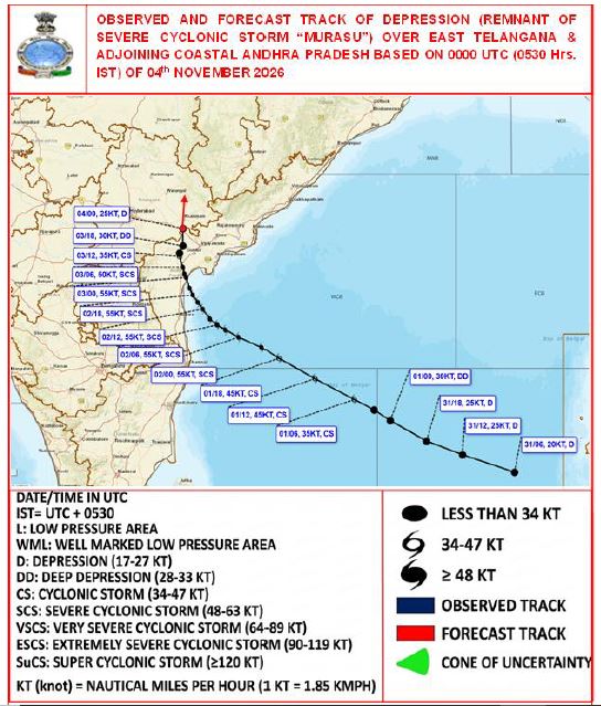
- October 31, 2026 – Depression Develops: A depression formed over the Bay of Bengal. The IMD began monitoring its movement and warned that the system could intensify into a cyclonic storm while approaching the south Andhra Pradesh coast.
- November 1, 2026 – Cyclonic Storm Murasu Forms: The depression intensified into Cyclonic Storm Murasu over the southwest and adjoining west-central Bay of Bengal. It kept moving towards the Andhra Pradesh coast while gradually gaining strength.
- November 2, 2026 – Severe Cyclonic Storm: Murasu strengthened into a Severe Cyclonic Storm, bringing strong winds and dangerous sea conditions. The cyclone moved closer to the Andhra Pradesh coast, and the IMD issued a Red Message cyclone warning.
- November 3, 2026 – Landfall Near Ongole: Cyclone Murasu crossed the south Andhra Pradesh coast between Nellore and Narsapur, close to Ongole, in the early morning. Maximum sustained winds reached 100-110 kmph, gusting to 120 kmph.
- November 3, 2026 – Expected Weakening: After landfall, the cyclone was forecast to lose intensity gradually while moving inland. It was expected to weaken from a Severe Cyclonic Storm into a Cyclonic Storm and later into a Deep Depression.
- November 4, 2026 – weakened into a Depression: Cyclone Murasu has weakened into a Depression over east Telangana and adjoining Coastal Andhra Pradesh. The IMD forecasts that the system will weaken further into a Well-Marked Low-Pressure Area, although heavy to very heavy rainfall, waterlogging and localised flooding risks may continue across affected regions.
Note: Events from early morning of November 4 onward are forecasts.
Cyclone Murasu 2026 IMD Warnings
The India Meteorological Department (IMD) has issued warnings for Cyclone Murasu, highlighting the risks of extremely heavy rainfall, strong winds, rough seas, storm surges and flooding. Coastal Andhra Pradesh faces the highest risk during landfall, while neighbouring states may also experience severe weather conditions.
- Heavy Rainfall Warning: North Coastal Andhra Pradesh and east Telangana are likely to experience heavy to very heavy rainfall at isolated places on November 4. South Odisha, south Chhattisgarh and north Tamil Nadu may receive heavy rainfall at isolated places, with light to moderate rainfall across several areas.
- Wind Warning: East Telangana, North Coastal Andhra Pradesh and the west-central Bay of Bengal are likely to experience squally winds of 40–50 kmph, gusting to 60 kmph. Wind speeds are expected to decrease gradually as the weakened cyclone moves inland.
- Sea Condition Warning: Rough sea conditions are expected over the west-central Bay of Bengal, particularly along and off the North Andhra Pradesh coast. Marine conditions are likely to improve gradually as the system weakens.
- Flash Flood Warning: The IMD has indicated a low to moderate flash flood risk in parts of Coastal Andhra Pradesh and Yanam, including Anakapalli, Bapatla, Dr. B.R. Ambedkar Konaseema, East Godavari, Guntur, Kakinada, Krishna, NTR, Visakhapatnam and West Godavari districts.
- Fishermen Warning: Fishermen have been advised not to venture into the west-central Bay of Bengal along and off the Andhra Pradesh coast until noon on November 4. Fishing activities and the movement of small boats remain unsafe during the warning period.
- Transport and Infrastructure Warning: Heavy rainfall, waterlogging and strong winds may damage kutcha roads, vulnerable houses, electricity poles and communication infrastructure. Localised flooding may disrupt road and rail transport, particularly in low-lying and urban areas.
- Public Safety Advisory: Residents in affected areas should remain indoors, avoid unsafe structures and waterlogged roads, and follow official IMD and local administration advisories. Authorities have been advised to regulate road and rail traffic and monitor vulnerable coastal and flood-prone areas.
Cyclone Murasu 2026 Impacts
Although Cyclone Murasu has weakened into a Depression, its remnants continue to pose risks to agriculture, infrastructure, transport and coastal communities. According to the November 4 IMD advisory, heavy rainfall and strong winds may cause localised flooding and disruption across parts of Andhra Pradesh, Telangana, south Odisha, Chhattisgarh and north Tamil Nadu.
- Loss of Lives and Property Damage: Cyclone Murasu claimed at least two lives in Andhra Pradesh, damaging 52,459 hectares of standing crops, 312 houses and power transmission lines. According to the Andhra Pradesh State Disaster Management Authority (APSDMA), around 12,230 people were accommodated in rehabilitation centres across Guntur, Bapatla and Palnadu, the worst-affected districts.
- Heavy Rainfall and Flooding: Heavy to very heavy rainfall in North Coastal Andhra Pradesh and east Telangana may trigger urban flooding, riverine flooding and waterlogging, particularly in low-lying settlements.
- Strong Winds and Structural Damage: Squally winds reaching 40-50 kmph, gusting to 60 kmph, may damage thatched houses, kutcha structures, tin roofs and vulnerable buildings. Falling tree branches and detached hoardings may create additional hazards.
- Agricultural Losses: Heavy rainfall and strong winds may damage standing crops, orchards, plantations and horticultural crops, particularly banana, papaya, coconut and drumstick trees. Coastal agricultural fields and salt pans also remain vulnerable.
- Electricity and Communication Disruptions: Strong winds and falling branches may cause minor damage to electricity poles and communication infrastructure, potentially affecting essential services in vulnerable areas.
- Fishing and Coastal Livelihoods: Rough sea conditions and temporary fishing restrictions may disrupt fishing activities, coastal trade and marine transportation along the Andhra Pradesh coast.
- Transport and Infrastructure: Waterlogging, flooded roads and damage to kutcha roads may disrupt road and rail services. Heavy rainfall could also affect railway signalling systems and overhead power lines.
- Flash Flood Risk: A low to moderate flash flood risk remains in several districts of Coastal Andhra Pradesh and Yanam, potentially affecting settlements, roads and agricultural land.
- Pressure on Essential Services: Flooding and infrastructure damage may disrupt access to safe drinking water, sanitation, healthcare and emergency transportation in affected communities.
These are primarily forecast or potential impacts as of November 4, 2026, rather than confirmed final damage figures.
Cyclone Murasu 2026 Preparedness
Preparedness measures following Cyclone Murasu’s landfall focus on public safety, flood prevention, transport regulation and protection of vulnerable communities. Although the cyclone has weakened, authorities and residents must remain alert to heavy rainfall, localised flooding and strong winds.
- Early Warning and Monitoring: The IMD continues monitoring the weakened cyclone system through Doppler Weather Radars at Machilipatnam and Visakhapatnam, providing updated weather and rainfall warnings.
- Public Safety Measures: Residents in affected areas have been advised to remain indoors, avoid vulnerable buildings and follow instructions issued by local authorities.
- Fishing Restrictions: The IMD has advised the suspension of fishing operations along and off the Andhra Pradesh coast until November 4 noon, with fishermen instructed to follow subsequent marine warnings.
- Transport Regulation: Authorities have been advised to regulate road and rail traffic, issue necessary travel advisories and prevent movement through flooded and waterlogged areas.
- Flood Risk Management: The IMD has identified low to moderate flash flood risks in parts of Coastal Andhra Pradesh and Yanam, requiring close attention to vulnerable watersheds and low-lying areas.
- Protection of Agriculture: Farmers should take precautions to protect standing crops, plantations and orchards from heavy rainfall, waterlogging and strong winds.
- Marine Safety Measures: The movement of motorboats and small ships remains unsafe during the warning period. Fishing harbour authorities have been advised to alert fishermen and monitor subsequent IMD advisories.
- Infrastructure Safety: Authorities should monitor vulnerable houses, electricity poles, communication systems and transport infrastructure to reduce risks from strong winds, falling branches and flooding.
- Interdepartmental Coordination: District administrations, fisheries departments, transport authorities and emergency response agencies should coordinate safety measures based on updated IMD warnings.
Why is the Bay of Bengal Prone to Cyclonic Storms?
The Bay of Bengal is one of the major cyclone-prone regions of the North Indian Ocean. Cyclones such as Murasu develop under favourable oceanic and atmospheric conditions, making the eastern coast of India particularly vulnerable to tropical storms.
- Warm sea surface temperatures: Warm ocean waters provide the heat and moisture necessary for cyclone formation. Sea surface temperatures of approximately 26.5°C or higher can support tropical cyclone development when other conditions are favourable.
- High atmospheric moisture: Moist air over the Bay of Bengal supports the formation of deep rain-bearing clouds and thunderstorms, helping developing cyclonic systems intensify.
- Post-monsoon cyclone activity: October to December is an important cyclone season in the North Indian Ocean. During this period, favourable atmospheric conditions can support the formation and strengthening of tropical cyclones.
- Favourable atmospheric conditions: Low vertical wind shear, sufficient Coriolis force, atmospheric instability and an existing low-pressure disturbance can allow cyclonic circulation to develop and strengthen.
- Movement towards India’s eastern coast: Large-scale atmospheric circulation influences cyclone tracks. Storms moving westwards or northwestwards across the Bay of Bengal may approach Andhra Pradesh, Odisha, Tamil Nadu and West Bengal.
- Funnel-shaped northern Bay of Bengal: The narrowing shape and shallow coastal waters of the northern Bay of Bengal can amplify storm surges, increasing the risk of coastal flooding during powerful cyclones.

 Last updated on Nov, 2026
→ UPSC Interview 2026 is scheduled from 7 December 2026 to 12 February 2027.
→ UPSC Interview Guidance Programme (IGP) 2026 by Vajiram & Ravi helps aspirants prepare confidently for the UPSC Personality Test.
→ UPSC DAF 2026 application form is available from 11 to 25 November 2026, till 6:00 PM.
→ UPSC 2027 Notification will be released on 13 January 2027 at upsconline.nic.in.
→ Download PIB PRiSM Monthly Magazine 2026 here.
→ Check UPSC Monthly Current Affairs Magazine The Recitals here.
→ Check out the latest UPSC Syllabus here.
→ UPSC Calendar 2027 has been released.
→ Enroll in Vajiram & Ravi’s UPSC Mains Test Series 2027 for structured answer writing practice, expert evaluation, and exam-oriented feedback.
→ Join Vajiram & Ravi’s UPSC Mentorship Program 2027 for personalized guidance, strategy planning, and one-to-one support from experienced mentors.
→ Go through the UPSC Mains Previous Year Papers to enhance your preparation.
→ UPSC has released UPSC Toppers List 2025 with the Civil Services final result on its official website.
→ Also check Best UPSC Coaching in India
Cyclone Murasu 2026 FAQs
Q1. What is Cyclone Murasu 2026?+
Q2. When will Cyclone Murasu make landfall?+
Q3. Which country is named Cyclone Murasu, and what does it mean?+
Q4. How strong is Cyclone Murasu?+
Q5. Which areas are affected by Cyclone Murasu?+
Q6. Why is the Bay of Bengal prone to cyclones?+
Tags: cyclone cyclone murasu cyclone murasu 2026