Living Planet Report 2026

Living Planet Report 2026

Living Planet Report 2026 Latest News

Recently, the Living Planet Report 2026 was released which found that there is a 73 per cent decline in the average size of monitored wildlife populations between 1970 and 2022.

About Living Planet Report 2026

  • It is published biennially by the World Wide Fund for Nature (WWF). 
  • It is a comprehensive study of trends in global biodiversity and the health of the planet. 
  • This year it is the 16th edition of the report.
  • It utilises the Living Planet Index (LPI) to track average trends in wildlife populations.
    • The LPI is a measure of the state of the world’s biological diversity based on population trends of vertebrate species from terrestrial, freshwater and marine habitats.
    • It measures the average rate of change in population size across the species monitored.

Key Highlights of Living Planet Report 2026

  • Global Trend: The average size of monitored vertebrate populations declined 73% over 52 years between 1970 and 2022.
  • Ecosystem-wise Decline: The strongest declines were seen in freshwater ecosystems with average population sizes plunging 85%, followed by terrestrial ecosystems, at 69% and marine ecosystems at 59%.
  • Region wise decline: At a regional level, the steepest declines since 1970 have been recorded in Latin America and the Caribbean (-95%), Africa (-80%), and Asia and the Pacific (-49%).
  • Recovery of Wildlife: The report highlights recoveries in populations of green turtles, bluefin tuna, tigers and southern African elephants,
  • The report noted a rise in global wild tiger numbers between 2010 and 2025 — from 3,200 to around 5,700 individuals.
  • Causes of Wildlife Decline: Habitat loss and degradation, overexploitation of resources, climate change, and impact of invasive species, pollution and disease are some of the dominant drivers of changes across ecosystems and wildlife populations.

Source: DTE

Living Planet Report 2026 FAQs

Q1: What Living Planet Report published by which institute?

Ans: World Wide Fund for Nature

Q2: What does the Living Planet Report assess?

Ans: It is a comprehensive study of trends in global biodiversity and the health of the planet. 

SAREX-2026

SAREX-2026

SAREX-2026 Latest News

The Indian Coast Guard conducted the 12th National Maritime Search and Rescue Exercise (SAREX-2026) off Paradip, Odisha.

About SAREX-2026

  • It is a multi-agency exercise aimed to strengthen maritime safety and rescue operations aligned with “India's 'SAGAR' and 'Mahasagar' visions.”
  • It is being conducted by the Indian Coast Guard.
  • SAREX-2026 Theme: “Leveraging Technology to Strengthen SAR Preparedness and Maritime Safety.” 
  • Participants: It is being participated by 32 observers from 30 countries.
  • Their participation facilitated exchange of best practices, enhanced global interoperability and reaffirmed India’s role as a dependable maritime Search and Rescue partner in the region.
  • Participating forces and Assets: The assets deployed included 15 Coast Guard ships, three Dornier aircraft, three Advance Light Helicopters, one Chetak helicopter, IAF C-130J and Mi-17 aircraft, two Indian Navy ships, along with civil and state resources and shore-based support units. 
  • Activities Involved
    • The sea drill simulated a Mass Rescue Operation following a concurrent aeronautical and maritime distress emergency.
    • As part of the scenario, a passenger aircraft carrying 228 persons ditched at sea near Paradip Port, with the fuselage impacting the container vessel MV Zumba, resulting in structural damage and fire.
    • The exercise involved activation of the Incident Command Post, firefighting operations, helicopter evacuations, deployment of life rafts and air-droppable life rafts, Jason Cradle and Gemini recovery, rescue basket operations and scramble net procedures.
    • The exercise also included a demonstration of Remotely Operated Vehicle (ROV) capability.

Source: PIB

SAREX-2026 FAQs

Q1: What is the aim of SAREX-2026?

Ans: It is aimed to strengthen maritime safety and rescue operations aligned with “India's 'SAGAR' and 'Mahasagar' visions.”

Q2: What is the theme of SAREX-2026?

Ans: Leveraging Technology to Strengthen SAR Preparedness and Maritime Safety

Diamondback Terrapin

Diamondback Terrapin

Diamondback Terrapin Latest News

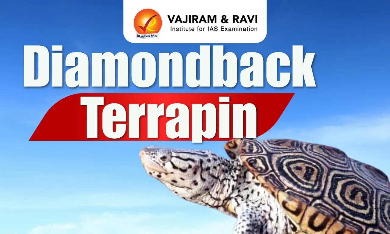
Recently, a rare two headed diamondback terrapin hatchling has been discovered on Cape Cod, Massachusetts.  

About Diamondback Terrapin   

  • The Diamondback terrapin (Malaclemys terrapin) is a species of turtle.
  • Habitat: It inhabits saltwater habitats, including brackish channels, lagoons, tidal flats, marshes, estuarine areas, and coastlines.
  • Distribution
    • It is native to the Northeastern and southern United States, and in Bermuda.
    • It occurs along parts of the eastern coast of the United States from as far north as Cape Cod, Massachusetts, to the southernmost Florida Keys.
  • Appearance
    • The common name of these turtles refers to the diamond pattern on top of their shell
    • All have a unique pattern of wiggly, black markings or spots on their body and head.
  • Characteristics
    • These terrapins have large webbed feet and are very strong swimmers.
    • These turtles spend the majority of their life in water, however, they do leave the water to bask and lay eggs.
    • Adult Diamondback terrapins hibernate in the colder months in most of their range, in the mud of creeks and marshes.
    • Food Habit: These terrapins are carnivores. They typically feed on fish, marine snails, clams, mussels, and other mollusks.
  • Conservation Status: IUCN Red List: Vulnerable

Source: IE

Diamondback Terrapin FAQs

Q1: Where does Diamondback Terrapin found?

Ans: It is native to the Northeastern and southern United States, and in Bermuda.

Q2: In which habitat Diamondback Terrapin is found?

Ans: It inhabits saltwater habitats, including brackish channels, lagoons, tidal flats, marshes, estuarine areas, and coastlines.

Plan Bee System

Plan Bee System

Plan Bee System Latest News

The Northeast Frontier Railway (NFR) has used AI-based alerts, speed restrictions, enhanced patrolling and its ‘Plan Bee’ system to prevent train-elephant collisions.

About Plan Bee System

  • It is an innovative acoustic deterrent system developed by the Northeast Frontier Railway (NFR).
  • It is developed to prevent wild elephants from straying onto railway tracks and being hit by trains.
  • Working: The system uses amplified honeybee sounds to discourage elephants from approaching railway tracks.
  • It has been installed at 56 locations under the NFR jurisdiction, where the train lines cut through forests or elephant habitats.
  • Through this device, the buzzing sound of bees will be audible from a distance of 400 metres.

Key Facts about Northeast Frontier Railway

  • It is headquartered at Maligaon near Guwahati, Assam.
  • It operates across the Northeastern states, as well as seven districts of West Bengal and five districts of north Bihar.

Source: ET

Plan Bee System FAQs

Q1: What is Plan Bee System?

Ans: It is an innovative acoustic deterrent system developed by the Northeast Frontier Railway (NFR).

Q2: How does Plan Bee System works?

Ans: It is developed to prevent wild elephants from straying onto railway tracks and being hit by trains.

Trade and Development Report 2026

Trade and Development Report 2026

Trade and Development Report Latest News

India’s share in global greenfield investments during 2020-25, at 5.7%, is more than double China’s share in such investments during the same period, according to the latest Trade and Development Report 2026 report by UNCTAD.

About Trade and Development Report 

  • First launched in 1981, it is issued every year by the UN Trade and Development (UNCTAD).
  • The report analyses current economic trends and major policy issues of international concern and makes suggestions for addressing these issues at various levels.

Trade and Development Report 2026 Highlights

  • Global trade is projected to grow by 4% in 2026, slower than the previous year’s 4.4%, but well above what was anticipated when the conflict in the Middle East began.
  • Global trade reached a record $35 trillion in 2025.
  • The report indicates higher trade values resulting from energy price increases and export controls.
  • While trade between China and the US has fallen by more than 20% since 2024, East Asia has expanded trade with both China and North America.
  • Developing economies, particularly India, are expected to drive notable growth despite overall global economic slowdowns.
  • Global economic growth will likely slow to 2.6% in 2026, down from 2.9% last year, but developing economies are projected to grow 4% this year, down from 4.7% in 2025.
  • Asia is projected to contribute 59% of global growth in 2026.
  • The report showed that governments increasingly use industrial, trade, financial, and technology policies to pursue economic and national security objectives.
  • Artificial intelligence products, comprising advanced computing equipment deployed primarily in new data centres, have become the main driver of merchandise trade; 82% of value added accrues to four supplier segments in this category.
  • From 2020 to 2025, strategic sectors grew from 16% to 44% of global greenfield investment.
    • Among these strategic sectors, artificial intelligence (AI) infrastructure and related technologies attracted the largest share of 12.4% of the $845.7 billion of overall global greenfield investment that took place within this period. 
    • AI infrastructure was followed by the semiconductor value chain (8.1%) and energy transition technologies and services (7.8%). 
  • Strategic investment is concentrated in Europe (28.4%) and North America (28%). Even among developing economies, capital is primarily funnelled into developing Asia (26.5%) with China, India, Indonesia, Malaysia, and Singapore as leading jurisdictions for new investments.
  • India Specific Findings:
    • India accounted for 5.7% of global greenfield investments during 2020 to 2025, followed by Malaysia (4%), Indonesia (3.8%), and China (2.8%). 
    • India ranks high in terms of the number of industrial policies it has implemented over the last two decades or so. 
    • During 2008-21, India implemented 1,416 industrial policies, behind only China (4,201) and the U.S. (4,025) 
    • In the much shorter period 2022-25, data shows India implemented 707 industrial policy measures, about half the number it did in the 2008-21 period.  It fell in the rankings during this period, with the U.S., China, Australia, and Brazil all implementing more industrial policies than India did. 
    • India is the fastest-growing major economy, with GDP projected to expand by 7.3% in 2026 and 6.8% in 2027 due to robust domestic demand, increasing manufacturing capacity, and public infrastructure programmes. 
    • It added that these factors are together sustaining growth despite India’s heavy reliance on oil imports.
    • India continues to post dynamic growth in household consumption, estimated at 6.9% this year and 5.6% next.

News:TH

Trade and Development Report FAQs

Q1: Which organisation publishes the Trade and Development Report (TDR)?

Ans: UN Trade and Development (UNCTAD).

Q2: What is the projected growth rate of global trade in 2026, according to Trade and Development Report (TDR) 2026?

Ans: Global trade is projected to grow by 4% in 2026.

Q3: What share of global greenfield investment did India attract during 2020–2025 according to Trade and Development Report (TDR) 2026?

Ans: India accounted for 5.7% of global greenfield investment during 2020–2025.

Q4: What is India's projected GDP growth rate for 2026, according to Trade and Development Report (TDR) 2026?

Ans: India's GDP is projected to grow by 7.3% in 2026.

Sepahijala Wildlife Sanctuary

Sepahijala Wildlife Sanctuary

Sepahijala Wildlife Sanctuary Latest News

Sepahijala Zoological Park of Sepahijala Wildlife sanctuary has welcomed three new Royal Bengal tiger cubs, taking the zoo’s tiger population to seven. 

About Sepahijala Wildlife Sanctuary

  • Location: It is located in the state of Tripura.
  • Lakes: It also has two natural lakes, namely Abasarika and Amrit Sagar.
  • The Clouded Leopard National Park was established in 2007 as a core zone inside this sanctuary.
  • Vegetation: It mainly consists of moist deciduous forest.
  • Flora 
    • It has 456 plant species. There are trees of Sal, Chamal, Garjan, and Kanak. 
    • The secondary species consist of Pichla, Kurcha, Awla, Bahera, Hargaja, Amlaki, Bamboos and grasses, are also found here. 
  • Fauna
    • It is the habitat of different species of primates like the Rhesus macaque, Pigtailed macaque, Capped langur, Spectacled monkey, Slow loris and several other wild animals like Leopard, Clouded leopard, Jungle fowl, Civets, Barking, Deer, Wild pig, etc.
    • The crab-eating mongoose (which was last seen in the 1930s) has also been revived here.
    • The avian population of the sanctuary is also rich, with a variety of winged stork, Whistling teal, and the White ibis.

Source: NET

Sepahijala Wildlife Sanctuary FAQ's

Q1: Where is Sepahijala Wildlife Sanctuary located?

Ans: Tripura

Q2: Which lakes are part of the Sepahijala Wildlife Sanctuary?

Ans: It has two natural lakes, namely Abasarika and Amrit Sagar.

Mali

Mali

Mali Latest News

Recently, the Permanent Missions of India and Mali commemorated World Cotton Day at the United Nations Headquarters in New York. 

About Mali

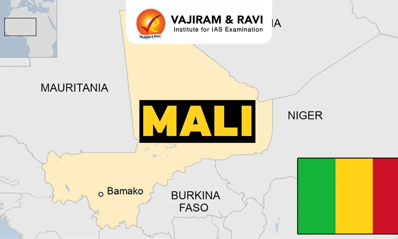
  • Location: It is a landlocked country in West Africa.
  • Bordering Countries: It shares its border with Algeria (north), Niger and Burkina Faso (east), Côte d’Ivoire and Guinea (south), and Senegal and Mauritania (west).
  • Capital City: Bamako

Geographical Features of Mali

  • Climate: It experiences a tropical savanna climate in the south becoming a desert climate in the north. 
  • Topography: Approximately 65% of the country is covered by desert or semi-desert.
  • The Sahara Desert makes up a large portion of Mali’s total land area. 
  • The landscape transitions from the Sahara Desert in the north through the Sahel to the zone of Sudanian savanna in the south.
  • River: The Niger River flows through its interior, serving as its main source of water. 
  • Highest point:  Hombori Tondo at 3,789 ft (1,155 m).
  • Natural Resources: It includes gold, uranium, diamonds, copper, iron ore, precious stones, zinc, manganese, bauxite etc.

Source: PIB

Mali FAQs

Q1: What is the capital city of Mali?

Ans: Bamako

Q2: Mali experience what type of climate?

Ans: It experiences a tropical savanna climate in the south becoming a desert climate in the north. 

Pong Dam

Pong Dam

Pong Dam Latest News

Alleged movement of fishing boats and laying of nets in the restricted area of the Pong Dam in lower Kangra, including the right-side barrier and reserve zone of the Pong Dam Reservoir, also known as Maharana Pratap Sagar, has raised security concerns.

About Pong Dam

  • The Pong Dam, also known as the Beas Dam, is an earth-fill embankment dam constructed on the river Beas in the wetland of Shivalik hills in the Kangra district of Himachal Pradesh.
  • The construction of the dam began in the year 1961 and was completed in 1974, and at that time it was known as the tallest of its type in the country.
  • The height of this dam is close to 133 m, while the width at the bottom remains 610 m.
  • It was constructed for generating hydroelectricity and for irrigation purposes.
  • The dam’s spillway is controlled by six radial gates affixed on the southern side of it. The base of the dam contains a powerhouse. 
  • The construction of a dam created an artificial lake called the Maharana Pratap Sagar, after the great ruler of Mewar.
    • Known widely as the Pong Reservoir or the Pong Dam Lake, it was declared a bird sanctuary in 1983 due to its waterfowl diversity. 
    • Over time, the reservoir emerged as a sanctuary for migratory birds, leading to its designation as a Ramsar Wetland Site in 2002.
    • It is home to several species of avifauna, some of which include Barheaded Geese, Red-neck Grebe, northern lapwing, common teal, spot-billed duck, Eurasian coot, black stork, egrests, etc.
    • Sprawling over an area of over 240 sq.km., the lake is also an important fish reservoir that acts as a fish breeding ground for commercial purposes. 
    • The Dhauladhar mountains ensconce the Pong Dam lake from all sides. 
    • Since the lake is an extension of the perennial Beas river that flows from the Rohtang Pass, it contains water throughout the year. 
    • Also, the Pong Dam ensures adequate water levels in the lake at all times.

News: TRIB

Pong Dam FAQs

Q1: On which river is Pong Dam constructed?

Ans: Pong Dam is constructed on the Beas River.

Q2: In which state is Pong Dam located?

Ans: Pong Dam is located in Himachal Pradesh.

Q3: What type of dam is Pong Dam?

Ans: Pong Dam is an earth-fill embankment dam.

Q4: What is the name of the artificial lake created by Pong Dam?

Ans: The artificial lake created by Pong Dam is called Maharana Pratap Sagar.

Q5: When was Pong Dam Lake designated as a Ramsar site?

Ans: Pong Dam Lake was designated as a Ramsar site in 2002.

Mangrol- Anti-Submarine Warfare Shallow Water Craft

INS Mangrol

Mangrol - Anti-Submarine Warfare Shallow Water Craft Latest News

The Indian Navy will commission Mangrol, the third Anti-Submarine Warfare Shallow Water Craft (ASW-SWC) built by Cochin Shipyard Limited (CSL), at the Naval Dockyard in Mumbai.

About Mangrol - Anti-Submarine Warfare Shallow Water Craft    

  • It is the third Anti-Submarine Warfare Shallow Water Craft (ASW-SWC) built by Cochin Shipyard Limited (CSL), Kochi.
  • It is named after Mangrol, a coastal town and prominent fishing harbour in Gujarat's Junagadh district.
  • It is designed to detect and counter underwater threats in coastal and shallow waters,

Features of Mangrol

  • Armaments: It is equipped with modern weapons and sensors, including the Abhay Hull-Mounted Sonar, lightweight torpedoes, an indigenous anti-submarine rocket launcher and the Maareech Advanced Torpedo Decoy System.
  • Propulsion: It is powered by three diesel engines with waterjet propulsion, the ship offers high manoeuvrability for operations in shallow waters.
  • It is also capable of undertaking underwater surveillance, Low-Intensity Maritime Operations and mine warfare-related tasks.
  • The ship can operate alongside maritime patrol aircraft, helicopters and other warships to detect and counter submarine threats.
  • Significance: Its induction will enhance the Navy's ability to protect ports, harbours and coastal approaches while supporting wider fleet operations.

Source: PIB

Mangrol -Anti-Submarine Warfare Shallow Water Craft FAQs

Q1: Mangrol - Anti-Submarine Warfare Shallow Water Craft was developed by which organisation?

Ans: Cochin Shipyard Limited (CSL), Kochi

Q2: What is the role of Mangrol -Anti-Submarine Warfare Shallow Water Craft?

Ans: It is designed to detect and counter underwater threats in coastal and shallow waters,

Vertical Launch Short Range Surface-to-Air Missile

Vertical Launch Short Range Surface-to-Air Missile

Vertical Launch Short Range Surface-to-Air Missile Latest News

The Defence Research and Development Organisation (DRDO) is making rapid progress on a homegrown shield for Indian warships, the Vertical Launch Short Range Surface-to-Air Missile (VL-SRSAM).

About Vertical Launch Short Range Surface-to-Air Missile

  • It is an indigenously developed Short-Range Surface-to-Air Missile (SRSAM).
  • It is designed and developed by the Defence Research & Development Organisation (DRDO) for the Indian Navy.
  • It is primarily a ship-based weapon for neutralising various aerial threats at close ranges.
  • Its primary mission is to intercept "sea-skimming" targets—missiles or drones that fly just above the ocean surface to evade early radar detection. 

Vertical Launch Short Range Surface-to-Air Missile Features

  • Having a diameter of 178 mm and a wingspan of 508 mm, the missile is 3.93 metres long.
  • Powered by a solid-propellant motor, the missile can hit top speeds of Mach 4.
  • It is capable of engaging threats up to an operational range of 80 km and an altitude of 16 km.
  • The system's vertical launch capability is one of its most crucial operational advantages. 
  • By firing straight up from canister-based launchers before turning toward its target, the missile provides 360-degree coverage. 
  • This means a warship can intercept an incoming threat from any direction without needing to physically rotate the vessel or adjust a mechanical launcher. 
  • It relies on a state-of-the-art Multi-Function Radar (MFR).
  • This Active Electronically Scanned Array (AESA) radar scans the sky, identifies threats, assigns priority, and feeds this critical data to the onboard Weapon Control Computer (WCC). 
  • As the missile approaches its target in the final phase of flight, an indigenous Radio Frequency (RF) seeker takes over to ensure pinpoint accuracy.

News: DEF

Vertical Launch Short Range Surface-to-Air Missile FAQs

Q1: What is the Vertical Launch Short Range Surface-to-Air Missile (VL-SRSAM)?

Ans: VL-SRSAM is an indigenously developed short-range surface-to-air missile designed to intercept aerial threats.

Q2: Which organisation has developed Vertical Launch Short Range Surface-to-Air Missile (VL-SRSAM)?

Ans: The Defence Research and Development Organisation (DRDO) has developed VL-SRSAM for the Indian Navy.

Q3: What type of propulsion system does Vertical Launch Short Range Surface-to-Air Missile (VL-SRSAM) use?

Ans: VL-SRSAM uses a solid-propellant rocket motor.

Q4: What is the operational range of Vertical Launch Short Range Surface-to-Air Missile (VL-SRSAM)?

Ans: VL-SRSAM has an operational range of up to 80 km.

Vikramshila University

Vikramshila University

Vikramshila University Latest News

Vikramshila University Set for Revival in Bihar

Why in the News?

  • After Nalanda University, another ancient centre of learning in Bihar—Vikramshila University—is set for revival.
  • The Archaeological Survey of India (ASI) is currently developing the ancient site to boost tourism.
  • The Bihar government has identified 202.14 acres in Antichak village, Bhagalpur, for establishing a Central University at the historic site.
  • The project was approved by the Centre in 2015 with an initial budget of ₹500 crore, but progress was delayed due to land acquisition issues.

About Vikramshila University

  • Location: Vikramshila University was situated in Bhagalpur, Bihar, along the banks of the river Ganges, making it a prominent historical site in eastern India.
  • Founder: The university was established by King Dharmapala of the Pala Dynasty during the late 8th to early 9th century AD, as a response to the perceived decline in educational standards at Nalanda University.
  • Significance:
    • Vikramshila University emerged as a leading hub for Tantric Buddhism and Vajrayana Buddhism, playing a pivotal role in the spread of these traditions.
    • The university distinguished itself by specializing in tantric and occult studies, setting it apart from Nalanda University, which offered a broader curriculum.
    • During King Dharmapala’s reign, Vikramshila exerted influence over Nalanda’s affairs, highlighting its administrative and academic dominance at the time.
    • It drew over 1000 students and 100 teachers from across India and beyond, reflecting its international reputation as a center of learning.
    • The institution produced renowned scholars like Atisa Dipankara, who significantly contributed to establishing Buddhism in Tibet.
  • Features:
    • Vikramshila University boasted a central stupa encircled by 208 cells, designed to house student-monks engaged in study and meditation.
    • It included a library equipped with a unique cooling system, channeling water from a nearby reservoir to preserve delicate manuscripts.
    • The curriculum encompassed a wide range of subjects, such as theology, philosophy, grammar, metaphysics, logic, and tantras, showcasing its academic diversity.
    • The university’s administration was overseen by a Kulpati or Mahasthavir, a distinctive leadership role that ensured its smooth functioning.
  • Decline: Vikramshila University met its end when it was destroyed by Muhammad Bin Bakhtiyar Khalji around 1203 AD, an event that also marked the downfall of Nalanda University.

Vikramshila University FAQs

Q1. What was Vikramshila University?

Ans. Vikramshila University was an ancient Buddhist learning center in Bihar, India, established by King Dharmapala of the Pala dynasty in the 8th–9th century CE. It was a major center for Buddhist studies, particularly for Tantric Buddhism (Vajrayana).

Q2. Where was Vikramshila University located?

Ans. It was situated at Antichak in Bhagalpur district, Bihar, on the banks of the Ganges River.

Q3. Why was Vikramshila University established?

Ans. It was established to revive and strengthen Buddhist learning, which was perceived to be declining at Nalanda University. It became a prominent center for advanced Buddhist education.

Q4. What subjects were taught at Vikramshila University?

Ans. The university specialized in Buddhist philosophy, logic, grammar, metaphysics, and Tantra (Vajrayana Buddhism). It also had studies in Sanskrit, law, and other traditional sciences.

Source: IE

Nagara style

Nagara style

About the Nagara style

  • Nagara architecture is a classical architecture of temple design in northern India, contrasted with Dravida architecture in southern India.
  • Nagara temples have a shikhara (mountain peak) over the garbha griha (sanctum sanctorum), a circumambulatory passage around it, and one or more mandapas (halls).
  • Shikhara is a symbolic representation of the cosmic order and the divine presence.
  • There are five modes of shikhara design: Valabhi, Phamsana, Latina, Shekhari, and Bhumija.
    • Valabhi and Phamsana are Early Nagara modes, derived from barrel-roofed wooden structures.
    • Latina is a single, slightly curved tower with four equal sides, ominant for three centuries.
    • Shekhari and Bhumija are composite Latinas with attached sub-spires or miniature spires, creating a complex and ornate appearance.
  • These modes are scholastic classifications, not rigid categories. There is much variation and innovation within and across these modes.

Q1) What is shikhara?

In North Indian temple architecture, the superstructure, tower, or spire above the sanctuary and also above the pillared mandapas (porches or halls); it is the most dominant and characteristic feature of the Hindu temple in the north.

Source: What is the Nagara style, in which Ayodhya’s Ram temple is being built

Enquire Now