Coastline Paradox Latest News
The coastline paradox reveals more than a peculiar measurement challenge: it underscores how science evolves with better tools.
Why in the News?
- In December 2024, the Union Ministry of Home Affairs made an important announcement as part of its 2023-2024 annual report.
- It said the length of India’s coastline had increased from 7,516.6 km to 11,098.8 km, and that the length is also currently under review.
- The 7,516.6 km figure was first recorded in the 1970s based on measurement techniques available at the time.
- The new revised figure wasn’t prompted by any territorial expansion through new land/island annexation or geological upheaval, like tectonic activity stretching the shores.
- The root of the discrepancy lies in geometry, in a problem called the coastline paradox.
About Coastline Paradox
- The British mathematician and physicist Lewis Fry Richardson first identified the coastline paradox in the early 1950s.
- His Polish-French peer Benoît Mandelbrot examined the problem mathematically in 1967 and also popularised it.
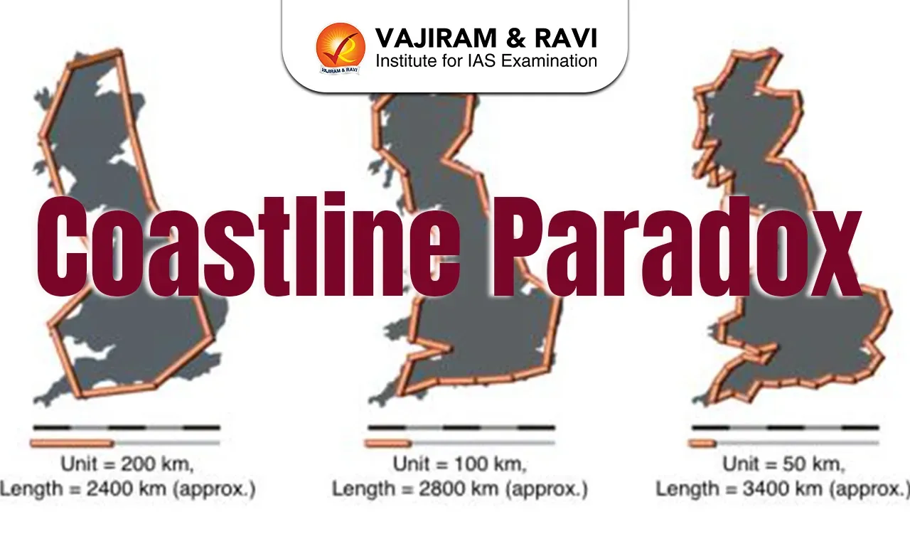
- The coastline paradox is a problem that comes from how you measure a coastline and that the length actually gets longer the more carefully you measure it.
- Meaning that the coastline of a landmass actually does not have a well-defined length but more of a fractal dimension.
- At the center of the coastline paradox is the observation that as the scale of measurement becomes smaller and more detailed, the measured length of the coastline increases.
- This is because smaller scales can capture more of the coastline’s intricate contours and jagged edges, which are overlooked at larger scales.
- The coastline paradox occurs because coasts are not straight lines, and this makes them difficult, or impossible, to measure definitively.
- For example, measuring a coastline with a 200-km-long ruler would smooth over most inlets and bends — but a 50-km ruler would detect them.
- At 1 km, the measurement will capture every estuary, tidal flat, and creek.
- So the more one refines the scale of the ruler, the longer the total coast becomes.
- Hypothetically, using a measurement unit the size of a water molecule would result in a coastline length approaching infinity.
- This dependence on scale underscores the inherent paradox: a finite piece of geography yielding a seemingly infinite measurement in cartography.
Coastline Paradox FAQs
Q1: Who discovered the coastline paradox?
Ans: The British mathematician and physicist Lewis Fry Richardson first identified the coastline paradox in the early 1950s.
Q2: What does the Coastline Paradox demonstrate about measuring coastlines?
Ans: The measured length increases as the scale of measurement becomes smaller.
Q3: Why does measuring a coastline with a smaller ruler result in a longer measured length?
Ans: They capture more of the coastline’s intricate details.
Source: TH
