Geotagging in Census Latest News
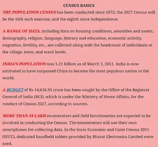
- India’s 2027 Census will introduce several firsts, including digital enumeration, self-enumeration, and caste counting after 1931.
- A major innovation will be geotagging of all buildings across the country. Each structure will be assigned precise GPS coordinates using mobile devices, ensuring accurate mapping of households and institutions.
- This will help remove duplication, improve coverage, and create a reliable spatial database to aid urban planning, infrastructure development, and better targeting of welfare schemes.
About Geotagging
- Geotagging is the process of marking a building’s exact latitude-longitude coordinates on a Geographic Information System (GIS) map.
- A GIS is a computer system that records, checks, and displays data linked to specific positions on Earth’s surface.
- Latitudes (horizontal lines) measure north-south distance from the equator, while longitudes (vertical lines) measure east-west distance from the prime meridian in Greenwich, UK.
- Together, these create a grid that allows any location to be uniquely identified.
- Through this system, geotagging assigns each building a precise locational identity that can be accurately pinpointed.
Number of Buildings in India (Census 2011)
- In Census 2011, a ‘Census House’ was defined as any building or part of a building with a separate main entrance, used as a distinct unit.
- Such houses could be occupied or vacant, and used for residential, non-residential, or mixed purposes.
- The Census recorded 330.84 million houses across India, of which 306.16 million were occupied and 24.67 million vacant.
- Rural areas accounted for 220.70 million houses, while 110.14 million were in urban areas.
How Geotagging Will Be Conducted in Census 2027
- Geotagging will take place during the Houselisting Operations (HLO), the first phase of the Census scheduled for April–September 2026.
- The second phase, Population Enumeration (will begin in February 2027) will record demographic, socioeconomic, and cultural details.
- In Ladakh, Jammu & Kashmir, Himachal Pradesh, and Uttarakhand, it will begin earlier in September 2026.
Role of Enumerators
- Enumerators will visit all buildings within their assigned Houselisting Blocks (HLBs) — clearly demarcated areas in villages or town wards with notional maps.
- Using Digital Layout Mapping (DLM) and smartphone apps, they will switch on location services and geotag each building.
- The exercise will record the number of Census Houses and Households in each building.
- Buildings will be classified as residential, non-residential, partly residential, or landmarks.
Definition of Household
- As per Census 2011, a household is a group of people normally living together and sharing meals from a common kitchen, unless prevented by work conditions.
Benefits of Geotagging in the Census
- Geotagging during the Census will provide accurate estimates of Census houses and households, ensuring better workload distribution for enumerators.
- Unlike earlier Censuses that relied on hand-drawn sketches, digital geotagging offers precision and efficiency.
- The government already uses geotagging on a smaller scale, such as for tracking houses built under Pradhan Mantri Awaas Yojana (PMAY) in rural and urban areas, demonstrating its practical usefulness.
Geotagging in Census FAQs
Q1: What is geotagging in Census?
Ans: Geotagging marks each building’s latitude and longitude on a GIS map, giving it a unique identity and ensuring precise data for Census operations.
Q2: How many buildings were recorded in Census 2011?
Ans: Census 2011 recorded 330.84 million houses in India, with 306.16 million occupied and 24.67 million vacant, spread across rural and urban areas.
Q3: When will geotagging be carried out?
Ans: Geotagging will take place during Houselisting Operations (April–September 2026), the first phase of Census 2027, using smartphones and Digital Layout Mapping.
Q4: How will enumerators conduct geotagging?
Ans: Enumerators will visit assigned Houselisting Blocks, switch on smartphone location, and geotag buildings while classifying them as residential, non-residential, or landmarks.
Q5: What are the benefits of geotagging in Census?
Ans: Geotagging ensures accurate workload distribution, eliminates duplication, and creates a spatial database useful for urban planning, infrastructure, and welfare targeting.
