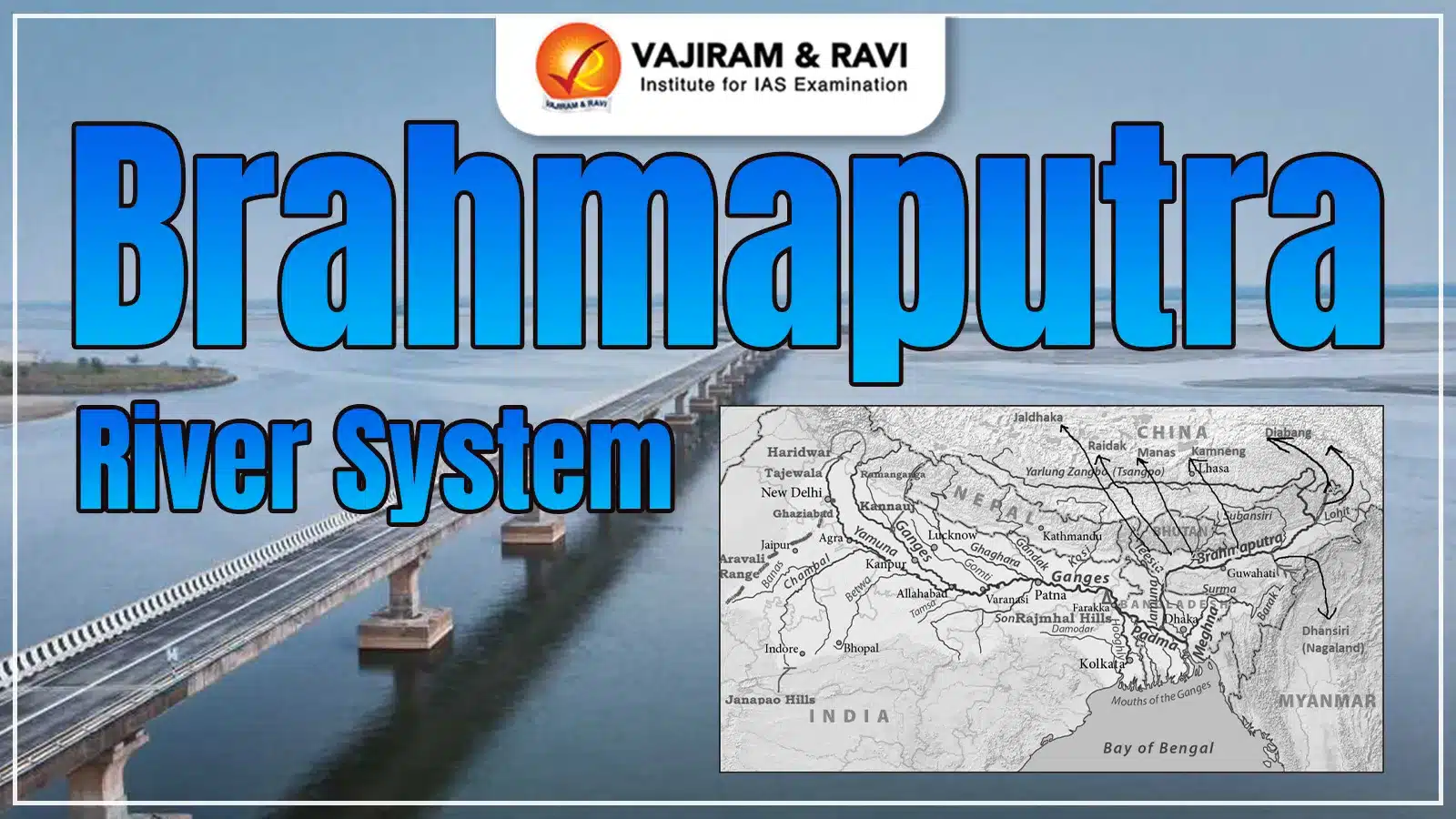
The Brahmaputra River System is one of Asia's largest and most significant river systems. It originates from the Chemayungdung Glacier, near Mount Kailash, in the Angsi Glacier region in southwestern Tibet. It then passes through Assam and Bangladesh, eventually merging with the Bay of Bengal.
The river spans across the Indian states of Assam and Arunachal Pradesh and plays a crucial role in the northeastern region of India. The Brahmaputra River rises in the eastern Tibetan Plateau course through India and Bangladesh. The river supports a diverse ecosystem, serving as shelter to a wide range of flora and fauna, including rare and endangered species.
Brahmaputra River System
The Brahmaputra River System is surrounded by the Himalayas to the north, the Patkai Hills to the east, the Assam Hills to the south, and the Himalayas again to the west. The Himalayan regions of Sikkim and Arunachal Pradesh, which form part of the Brahmaputra Basin, experience heavy snowfall. These regions also account for 55.48% of India’s total forest cover, making them some of the greenest areas in the country.
One of the most remarkable features of the Brahmaputra River System is Majuli, an island in Assam, which holds the distinction of being the world’s largest and oldest inhabited river island, recognized by UNESCO. The river system also has a significant hydropower potential of 66,065 MW, making it a crucial resource for renewable energy development.
As the Brahmaputra River flows from Kobo to Dhubri in Assam, it accumulates a large amount of sediment from its 20 tributaries on the north bank and 13 on the south bank. The region receives the majority of its annual rainfall during the South-West monsoon season, with 85% of the total precipitation occurring between May and September.
Brahmaputra River System Origin
The Brahmaputra, meaning "Son of Brahma," originates from the Chemayungdung glacier in southwestern Tibet. Its source lies in proximity to the origins of the Indus and Sutlej rivers. Despite its location at a remarkably high altitude, the Tsangpo River maintains a gentle gradient. It flows at a slow pace, forming a broad river channel that stretches for nearly 640 kilometers.
Brahmaputra River System Map
The Brahmaputra River has its origin in the Chemayungdung Glacier in southwestern Tibet. From there, it flows eastward across the Tibetan Plateau as the Yarlung Tsangpo River. This majestic river later enters India through Arunachal Pradesh, marking the beginning of its long journey across Northeast India. The Brahmaputra River System Map has been shared below.
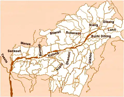
Brahmaputra River System Tributaries
The Brahmaputra River System Tributaries play a significant role in shaping its flow and water volume. The rivers in the Himalayan region are primarily glacier-fed, experiencing a rise in water levels during the monsoon season. Heavy rainfall, occurring between May and September due to the southwest monsoon, often leads to flooding in these rivers, impacting the Brahmaputra’s overall flow. The tributaries of the Brahmaputra are classified into two categories: northern (left-bank) tributaries and southern (right-bank) tributaries. These rivers contribute significantly to the river’s strength, often causing seasonal flooding.
| Brahmaputra River System Tributaries | |
|
Northern (Left-bank) Tributaries |
Southern (Right-bank) Tributaries |
|
Lhasa River |
Kameng River |
|
Nyang River |
Manas River |
|
Parlung Zangbo River |
Beki River |
|
Lohit River |
Raidak River |
|
Dhanashri River |
Jaldhaka River |
|
Kolong River |
Teesta River |
|
Subansiri River |
|
Brahmaputra River System Left Tributaries
The Brahmaputra River is fed by several significant tributaries that originate across Tibet, Arunachal Pradesh, and the Northeast Indian region. These rivers not only enrich the water volume of the Brahmaputra but also support hydropower generation, agriculture, flood regulation, and ecological balance. Below is a detailed table including the Brahmaputra River System Left Tributaries, their origins, the states or regions they pass through, and their key contributions to the river system and surrounding ecosystems.
| Brahmaputra River System Left Tributaries | |||
|
Tributary Name |
Origin |
States/Regions Covered |
Key Significance |
|
Lhasa River |
Tibet (Lhasa Plateau) |
Tibet |
Major tributary of Yarlung Tsangpo; contributes to Brahmaputra's upper flow |
|
Nyang River |
Nyangtri Prefecture, Tibet |
Tibet |
Enhances flow in Tibet; important for hydro development |
|
Parlung Zangbo River |
Tibet |
Tibet |
One of the easternmost contributors to the Tsangpo system |
|
Subansiri River |
Tibet |
Arunachal Pradesh, Assam |
Largest tributary; site of major hydropower projects |
|
Kameng River |
Tawang, Arunachal Pradesh |
Arunachal Pradesh, Assam |
Supports agriculture and biodiversity in West Kameng |
|
Lohit River |
Eastern Tibet |
Arunachal Pradesh, Assam |
Joins Siang & Dibang to form Brahmaputra; prone to floods |
|
Dhanashri (Dhansiri) |
Laisang Peak, Nagaland |
Nagaland, Assam |
Important for irrigation; passes through ecologically sensitive zones |
|
Kolong River |
Distributary of Brahmaputra |
Assam |
Supports inland navigation and local livelihoods |
Brahmaputra River System Right Tributaries
The Brahmaputra River System is enriched by various tributaries that originate in the Eastern Himalayas and the hills of Northeast India. These tributaries, flowing through diverse terrains and states like Assam, Meghalaya, Sikkim, and even Bhutan and Bangladesh, play an important role in shaping the region’s ecology, economy, and culture. Each river contributes uniquely, be it through hydroelectric potential, biodiversity support, irrigation, or transboundary cooperation. The following table highlights the Brahmaputra River System Right Tributaries detailing their origin, the regions they flow in, and their key significance.
| Brahmaputra River System Right Tributaries | |||
|
Tributary Name |
Origin |
States/Regions Covered |
Key Significance |
|
Manas River |
Bhutan Himalayas |
Bhutan, Assam |
A UNESCO World Heritage Site; supports rich biodiversity and wildlife sanctuaries. |
|
Beki River |
Himalayas in Bhutan |
Assam |
Important for fisheries, floodplain cultivation, and a tributary of the Manas River. |
|
Raidak River |
Northern Bhutan |
Bhutan, West Bengal, Assam |
Supports irrigation and hydropower; merges with the Brahmaputra near Dhubri. |
|
Jaldhaka River |
Bitang Lake (Sikkim-Bhutan border) |
Sikkim, West Bengal, Bangladesh |
Transboundary river; key for farming, hydroelectricity, and cross-border cooperation. |
|
Teesta River |
Pauhunri Glacier, Eastern Himalayas |
Sikkim, West Bengal, Bangladesh |
Major eastern Himalayan river; vital for hydro projects and Indo-Bangladesh water sharing. |
|
Kopili River |
Meghalaya Hills (Sapong Reserve) |
Meghalaya, Assam |
Major source for power and irrigation; joins Brahmaputra near Nagaon. |
|
Kulsi River |
Khasi Hills, Meghalaya |
Meghalaya, Assam |
Seasonal river; known for river dolphins; prone to flooding during monsoon. |
|
Dhansiri (South) |
Patkai Hills, Eastern Himalayas |
Arunachal Pradesh, Assam |
Important for floodplain agriculture and biodiversity; passes through Golaghat. |
|
Krishnai River |
West Garo Hills, Meghalaya |
Assam |
Seasonal river supporting agriculture; joins with Dudhnoi before meeting Brahmaputra. |
|
Dudhnoi River |
East Garo Hills, Meghalaya |
Assam |
Converges with Krishnai River; crucial for local irrigation systems. |
|
Jinjiram River |
East Garo Hills, Meghalaya |
Meghalaya, Assam |
Seasonal waterway; significant for flood management in the Goalpara district. |
|
Sonkosh (Sankosh) |
Bhutan |
Bhutan, Assam |
Borders Assam and West Bengal; joins Brahmaputra near Srirampur; irrigation support. |
States Through Which the Brahmaputra River Flows
The majestic Brahmaputra River, one of the longest and most important rivers in India, flows through several northeastern states before entering Bangladesh. In India, the Brahmaputra River passes through the states of Arunachal Pradesh, Assam, Meghalaya, Nagaland, West Bengal, and Sikkim. Originating from the Angsi Glacier in Tibet (where it is known as the Yarlung Tsangpo), the river enters India through Arunachal Pradesh as the Siang or Dihang River, flows majestically across Assam, and finally travels toward West Bengal before entering Bangladesh as the Jamuna River.
Cities Located on the Brahmaputra River
The Brahmaputra River flows through several important cities that play a key role in the cultural, economic, and geographical landscape of Northeast India. Major cities situated along the banks of the Brahmaputra River include Pasighat, Dibrugarh, Tezpur, Guwahati, and Goalpara.
- Pasighat (Arunachal Pradesh): One of the oldest towns in Arunachal Pradesh, Pasighat lies near the entry point of the Brahmaputra into India and is known for its scenic beauty.
- Dibrugarh (Assam): Often called the "Tea City of India," Dibrugarh is a major commercial hub located on the banks of the Brahmaputra.
- Tezpur (Assam): A historical and cultural city, Tezpur sits gracefully along the river, surrounded by lush landscapes.
- Guwahati (Assam): The largest city in Assam, Guwahati is an important river port and urban center along the Brahmaputra.
- Goalpara (Assam): Located in Lower Assam, Goalpara is another significant town positioned along the river’s fertile plains.
Brahmaputra River System List of Dams and Hydro Projects
Brahmaputra River System has its vast network of tributaries, it sustains diverse ecosystems and human settlements, contributing significantly to agriculture, culture, and the economy. Below in the table includes the Brahmaputra River System List of Dams and Hydro Projects:
| Brahmaputra River System List of Dams and Hydro Projects | ||
|
Dam |
Location |
Status |
|
Zangmu Dam |
Tibet, China |
Operational |
|
Jiacha Dam |
Tibet, China |
Under construction |
|
Dagu Dam |
Tibet, China |
Proposed |
|
Jiexu Dam |
Tibet, China |
Proposed |
|
Upper Subansiri Hydroelectric Project |
India |
Under construction |
|
Lower Subansiri Hydroelectric Project |
India |
Under construction |
|
Teesta-V (NHPC) Dam |
India |
Completed |
|
Teesta-III Dam |
India |
Under construction |
|
Rangit Dam |
India |
Completed |
|
Jaldhaka Hydroelectric Project |
India and Bhutan |
Operational |
|
Kurichu Hydroelectric Project |
Bhutan |
Operational |
|
Chukha Hydroelectric Project |
Bhutan |
Operational |
|
Tala Hydroelectric Project |
Bhutan |
Operational |
|
Daguchu Hydroelectric Project |
Bhutan |
Operational |
Different Names of Brahmaputra River
The Brahmaputra River is known by different names across its journey through various regions, reflecting diverse linguistic and cultural identities. Originating from Tibet, where it is revered as Tsangpo meaning "The Purifier," the river flows through China, India, and Bangladesh. In each of these regions, it adopts unique names.
| Different Names of Brahmaputra River | |
|
Region |
Name |
|
Tibet |
Tsangpo (meaning ‘The Purifier’) |
|
China |
Yarlung Zangbo, Jiangin |
|
Assam Valley |
Dihang or Siang, South of Sadiya: Brahmaputra |
|
Bangladesh |
Jamuna River |
|
Padma River: Combined Waters of Ganga and Brahmaputra |
|
|
Meghana: From the confluence of Padma and Meghna |
|
Brahmaputra River System FAQs
Q1: What is the river system of Brahmaputra?
Ans: The river originates from the Kailash ranges of Himalayas at an elevation of 5300 M.
Q2: What are the four names of Brahmaputra River?
Ans: Brahmaputra or Luit in Assamese, Yarlung Tsangpo in Tibetan, the Siang/Dihang River in Arunachali, and Jamuna River in Bengali.
Q3: Which glacier is the origin of the Brahmaputra River?
Ans: The Brahmaputra River originates from the Chemayungdung Glacier.
Q4: What is Brahmaputra called in China?
Ans: Tsangpo, the Brahmaputra is also known by its Chinese name.
Q5: Why is Brahmaputra called the red river?
Ans: The soil of this region is naturally rich in iron content, bringing the colour red to the river with a high concentration of red and yellow soil sediments.
