Australia and Oceania form one of the most diverse world regions, consisting of thousands of islands spread across the Central and South Pacific Ocean. Oceania is dominated by Australia, the world’s largest island and smallest continent, along with the micro-continent Zealandia (including New Zealand) and the western half of New Guinea forming Papua New Guinea. This region is geologically active, culturally diverse and geographically vast; stretching from the Strait of Malacca to the coasts of the Americas.
Australia and Oceania
Oceania covers the Central and South Pacific, composed of volcanic islands, coral atolls, micro-continents, limestone platforms, and large continental landmasses. Whereas, Australia lies completely in the Southern Hemisphere between the Indian and Pacific Oceans. The micro-continent Zealandia, nearly 90% submerged, includes New Zealand and a chain of submerged ridges and plateaus. Together they form one of the world’s largest cultural regions.
Australia and Oceania Geography
Australia is the smallest continent and the world’s largest island, lying entirely in the Southern Hemisphere. It extends roughly from 114°E to 154°E and 10°S to 40°S, situated between the Indian Ocean and the Pacific Ocean. Its area is nearly double the combined area of India and Pakistan. The Tropic of Capricorn divides the continent almost into two halves.
Oceania is known for its scattered islands, many of which were formed by volcanic eruptions or by coral reef buildup rising above sea level to form atolls and low coral islands. It includes the major island groups of Melanesia, Micronesia, and Polynesia.


Oceania Geography
Oceania is divided into three major island groups: Melanesia, Micronesia, and Polynesia.
- Melanesia: It is also known as Black Islands. Melanesia is located north and east of Australia. Major islands under this group are: East Timor, Fiji, New Caledonia, Papua New Guinea, Solomon Islands, Vanuatu. These islands arise from intense volcanic activity and tectonic uplift.
- Micronesia: These are also called little islands. It includes Guam, Kiribati, Marshall Islands, Palau, Nauru, Northern Mariana Islands. These islands include coral atolls formed by buildup of reefs around submerged volcanic peaks.
- Polynesia: These are referred to multiple/ many islands. Stretches from Midway Islands to New Zealand. It includes Hawaii, Samoa, Tonga, Tuvalu, French Polynesia, Cook Islands. The islands are formed by hotspot volcanism, coral reef growth, and plate tectonics.
Australia Geography
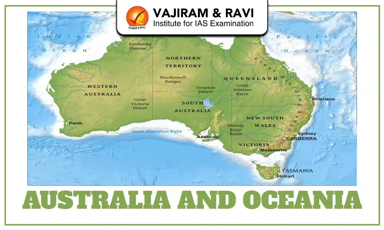
Australia is geographically surrounded by: Indian Ocean in the west, Timor Sea in the northwest, Gulf of Carpentaria in the north, Great Barrier Reef in the northeast, Great Australian Bight in the south and Tasmania to the southeast. Australia has 6 states: Western Australia, Queensland, South Australia, New South Wales, Victoria, and Tasmania; and 2 centrally administered territories. Major cities include: Sydney, Melbourne, Brisbane, Perth, Adelaide, Cairns, Darwin, and Canberra (capital). Australia is the lowest, most leveled continent, lacking major high mountains or river systems, with the highest peak as Mount Kosciuszko (2,230 m).
Australia Divisions
Australia is divided into four major physical divisions:
- Eastern Highlands (Great Dividing Range):
-
-
- The Great Dividing Range is the largest mountain system in Australia, stretching over 3,500 km from northeastern Queensland to western Victoria.
- It consists of uplands, plateaus, hills, and escarpments, not a single chain.
- It forms a major watershed dividing rivers draining to the Pacific from those flowing inland into the Murray-Darling Basin.
- In the north, some rivers drain into the Gulf of Carpentaria.
-
- Western Plateau:
-
-
- The Western Plateau is one of the world’s oldest landmasses, shaped by millions of years of erosion.
- It is characterized by: sinkholes, underground cave systems and a very dry climate influenced by the cold western Australian current.
- It contains major deserts such as: Gibson Desert, Great Sandy Desert, Great Victoria Desert, etc.
- This region was historically inhabited by several Aboriginal groups.The plateau is shaped by weathering associated with the cold West Australian Current, which reduces rainfall along western coasts.
-
- Central Lowland:
-
-
- The Central Lowlands lie between the Eastern Highlands and Western Plateau.
- This area is drained mainly by the Murray and Darling Rivers, Australia’s largest river system.
- Key features include:
- Great Artesian Basin: the world’s largest artesian groundwater system
- Highly productive irrigated agriculture supported by dams and reservoirs
- Lake Eyre Basin: over 1 million sq km, an endorheic lowland receiving interior drainage
-
- Great Barrier Reef:
-
- The Great Barrier Reef is the largest coral reef system on Earth.
- Length: ~2000 km
- Distance from coast: 16-200 km
- Location: Queensland coast, Pacific Ocean
- Formed by millions of coral polyps
- Listed as a UNESCO World Heritage Site and marked under “In Danger” list in 2023.
- It is home to over 1,500 fish species, 400 corals, etc.
- It is one of the most biodiverse marine ecosystems globally and faces climate-related coral bleaching events.
Australia Drainage System
Australia has low rainfall and high evaporation which results in the presence of a few major rivers only. Rivers like Murray (from Snowy Mountains), Darling, Lachlan, and Murrumbidgee support agriculture and livestock. Major drainage basins of Australia are:
- Murray-Darling Basin: known for the largest, used for irrigation and hydropower
- Lake Eyre Basin: it has internal drainage
- Swan River: it drains western coast
Australia Environment
Australia experiences diverse climate types due to its large north-south extent, majorly covering temperate and tropical along with other zones.
- Temperate Zones: covers the area of New South Wales, Victoria, Tasmania, SE South Australia and SW Western Australia Seasons include Summer (Dec-Feb), Autumn (Mar-May), Winter (Jun-Aug), Spring (Sep-Nov).
- Tropical Zones: It includes the region of northern Australia: Equatorial (Cape York), Tropical (Top End, Kimberley) and Sub-tropical (Queensland coast). It has mainly two seasons: Wet season: Nov-Mar and Dry season: Apr-Oct. Temperature ranges from 20°C (dry) to 50°C (wet), with frequent flooding during monsoons.
- Desert and Semi-Arid Zones: It covers vast central and western regions.
Australia has diverse vegetation zones:
- Downs (temperate grasslands): Murray-Darling Basin
- Tropical rainforests: north Queensland
- Savannas: tropical regions
- Deciduous forests: SE temperate belts
- Desert scrub and eucalyptus regions: interior arid zones
New Zealand Geography
New Zealand lies in the southwest Pacific and includes North Island and South Island, along with Stewart Island and numerous small islands. It sits on the Pacific and Australian Plates, making it one of the world’s most active tectonic regions. Sheep and cattle farming dominate New Zealand’s agricultural economy. The major physical features of New Zealand are:
- Landforms
-
-
- Southern Alps (South Island): Includes Mt. Cook (3,764 m), the highest peak
- Volcanic Plateau (North Island): Active volcanoes and geothermal areas
- Mt. Egmont (North Island): Extinct volcano
- Canterbury Plains: Largest plains, a piedmont alluvial region, major pastoral zone
- Taranaki Plain: Volcanic, fertile pastureland
-
- Major Cities
-
- Wellington: capital, southernmost national capital in the world
- Auckland: largest city, major port
- Christchurch: major South Island industrial centre
![]() Last updated on July, 2026
Last updated on July, 2026
→ UPSC Prelims Result 2026 is now out.
→ UPSC IFoS Prelims Result 2026 is now out.
→ Enroll in Vajiram & Ravi’s UPSC Mains Test Series 2026 for structured answer writing practice, expert evaluation, and exam-oriented feedback.
→ Join Vajiram & Ravi’s UPSC Mentorship Program 2026 for personalized guidance, strategy planning, and one-to-one support from experienced mentors.
→ Join Vajiram & Ravi’s UPSC Mentorship Program 2027 for personalized guidance, strategy planning, and one-to-one support from experienced mentors.
→ UPSC Prelims Provisional Answer Key 2026 out for GS Paper 1 and CSAT.
→ UPSC Prelims Question Paper 2026 Out, Download GS Paper 1 PDF conducted on 24th May 2026.
→ UPSC Mains 2026 will be conducted from 21st August 2026 onwards, and UPSC Prelims 2027 will be held on 23rd May 2027.
→ UPSC Final Result 2025 is now out.
→ UPSC has released UPSC Toppers List 2025 with the Civil Services final result on its official website.
→ Anuj Agnihotri secured AIR 1 in the UPSC Civil Services Examination 2025.
→ UPSC Notification 2026 & UPSC IFoS Notification 2026 is now out on the official website at upsconline.nic.in.
→ UPSC Calendar 2027 has been released.
→ Check out the latest UPSC Syllabus 2026 here.
→ The UPSC Selection Process is of 3 stages-Prelims, Mains and Interview.
→ Shakti Dubey secures AIR 1 in UPSC CSE Exam 2024.
→ Also check Best UPSC Coaching in India
Australia and Oceania FAQs
Q1. What regions are included in Australia and Oceania?+
Q2. Why is Australia considered a biodiversity hotspot?+
Q3. What is the economic significance of Oceania?+
Q4. What is a major environmental challenge in Oceania?+
Q5. How is India engaged with Australia and Oceania?+
Tags: australia and oceania