The Himalayan Drainage System is formed by rivers originating from glaciers and snow-capped peaks of the Himalayas, flowing through northern India and neighboring regions. These rivers evolved over millions of years due to tectonic uplift, glacial melt, and river erosion, shaping deep valleys and plains. They are perennial, fast-flowing, and sediment-rich, creating fertile lands and floodplains. The system is important for agriculture, water supply, hydroelectricity, navigation, and cultural-religious practices.
Himalayan Drainage System
The Himalayan Drainage System refers to the network of rivers that originate from the Himalayas and flow into the plains of India and neighboring countries. These rivers are primarily perennial, meaning they flow throughout the year due to the melting of snow and glaciers. They are vital for irrigation, hydroelectric power, and freshwater supply.
Himalayan Drainage System Evolution
The Himalayan Drainage System evolved due to the collision of the Indian Plate with the Eurasian Plate, which formed the Himalayas about 50 million years ago. Over time, the steep slopes and high gradients caused rivers to carve deep valleys and gorges.
- Tectonic Uplift and Formation of Himalayas: The Himalayan rivers originated due to the collision between the Indian Plate and the Eurasian Plate about 50 million years ago. This collision caused the uplift of the Himalayas, creating steep slopes and high-altitude glaciers, which became the primary sources of rivers like the Ganga, Yamuna, and Brahmaputra.
- Glacial and Snow-fed Sources: Most Himalayan rivers are perennial, fed by glaciers and snowfields in the Greater Himalayas. Glacial melt ensures that rivers maintain flow even during dry seasons, making them essential for water supply throughout the year.
- Erosion and Valley Formation: Fast-flowing Himalayan rivers have high velocity due to steep gradients, leading to intense vertical erosion. This process forms V-shaped valleys, deep gorges, and canyons, carving the rugged Himalayan terrain over millions of years.
- Sediment Transport and Fertile Plains: These rivers carry large amounts of silt, sand, and gravel, which they deposit in the plains. Over time, this has led to the formation of fertile alluvial plains, such as the Indo-Gangetic Plain, making the region highly productive for agriculture.
- River Course Changes and Delta Formation: Tectonic movements, erosion, and deposition have caused Himalayan rivers to alter their courses, meander, and form oxbow lakes. In the lower plains, continuous sediment deposition has created large deltas, like the Ganga-Brahmaputra Delta, which is one of the largest in the world.


Himalayan Drainage System Features
The features of the Himalayan Drainage System are discussed below in detail.
- Perennial Flow: These rivers flow throughout the year due to glacial melt and rainfall.
- Steep Gradient and Fast Flow: High slopes result in rapid river velocity, causing vertical erosion.
- V-Shaped Valleys and Gorges: Erosion forms narrow, deep valleys and spectacular gorges in the mountains.
- Heavy Sediment Load: Himalayan rivers carry silt, sand, and gravel, enriching downstream plains.
- Braided Channels: Some rivers split into multiple channels in the plains, forming braided patterns.
- Hydroelectric Potential: The steep flow makes them ideal for dams and hydroelectric projects.
Himalayan River System
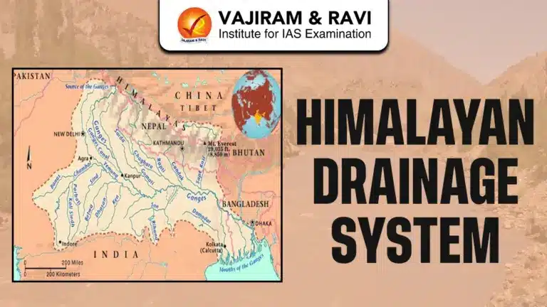
The Himalayan River System consists of major rivers that originate from the Himalayas and flow through the northern plains of India and neighboring countries. These rivers are perennial, fast-flowing, and heavily silt-laden, shaping valleys, floodplains, and deltas. The system is broadly divided into Indus, Ganga, Yamuna, and Brahmaputra rivers, each with unique tributaries and characteristics.
Indus River System
Origin: Glacier near Bokhar Chu in the Kailash Mountain Range, Tibet, near Mansarovar Lake.
Flow: Flows northwest, entering India at Demchok (Ladakh); runs between Karakoram and Ladakh ranges.
Tibet Name: Known as Singi Khamban (Lion’s Mouth) in Tibet.
Tributaries:
- Left-bank (India): Beas, Ravi
- Right-bank (India): Jhelum, Chenab, Sutlej
Features:
- Perennial and snow/glacier-fed
- Steep gradient in upper reaches; fast-flowing
- Fertile alluvial plains in Punjab and Sindh
- Important for irrigation and hydroelectric projects
Ganga River System
Origin: Gangotri Glacier, Uttarakhand
Flow: Flows eastward for 2,525 km, draining into the Bay of Bengal; crosses Uttarakhand, Uttar Pradesh, Bihar, Jharkhand, West Bengal.
Catchment Area: 8,61,404 sq. km (26.4% of India)
Major Tributaries:
- Left-bank: Ghaghara, Gandak, Kosi, Son
- Right-bank: Yamuna, Ramganga, Gomti, Damodar
Features:
- Perennial river with high sediment load
- Forms fertile alluvial plains supporting intensive agriculture
- Supports dense population and cultural/religious significance
Yamuna River System
Origin: Yamunotri Glacier, near Bandarpoonch Peak, Uttarakhand
Flow: Passes through Uttarakhand, Himachal Pradesh, Haryana, Delhi; merges with the Ganga at Triveni Sangam, Prayagraj
Length: Approximately 1,376 km
Tributaries:
- Left-bank: Tons, Ken, Betwa
- Right-bank: Chambal, Sindh, Hindon
Features:
- Largest tributary of the Ganga in northern plains
- Perennial and glacier-fed
- Forms fertile plains in Braj and Doab regions
- Vital for irrigation, drinking water, and urban supply
Brahmaputra River System
Origin: Chemayungdung Glacier, southwestern Tibet; source near Indus and Satluj
Tibet Name: Tsangpo River
Flow: Flows through Tibet, Arunachal Pradesh, Assam, Bangladesh; drains into Bay of Bengal
Tributaries:
- Left-bank: Dibang, Lohit, Subansiri
- Right-bank: Kameng, Manas, Raidak
Features:
- Perennial and glacier-fed
- Wide, navigable channels in plains; braided in Assam
- Prone to seasonal floods
- Supports fertile floodplains, agriculture, and transportation
Himalayan Drainage System Significance
The Himalayan Drainage System is crucial for India’s agriculture, water supply, hydroelectric power, transportation, and cultural heritage, supporting millions of people and fertile plains across northern India.
- Agricultural Importance: Rivers deposit fertile alluvial soil, forming the Indo-Gangetic plains, which are highly productive for crops like wheat, rice, and sugarcane.
- Perennial Water Supply: Glacial and snow-fed rivers ensure year-round availability of freshwater for domestic, industrial, and agricultural use.
- Hydroelectric Potential: Steep gradients and fast flow make rivers ideal for dams and hydroelectric projects, e.g., Tehri Dam (Ganga) and Bhakra Nangal (Sutlej).
- Irrigation Infrastructure: River systems support major irrigation networks like the Indira Gandhi Canal and Ganga Canal, enhancing food security.
- Navigation and Transportation: Some Himalayan rivers have navigable stretches, enabling inland transport and trade in regions like Assam (Brahmaputra).
- Floodplain Fertility: Seasonal floods deposit nutrient-rich sediments, enriching floodplains for agriculture.
- Cultural and Religious Significance: Rivers like Ganga and Yamuna are sacred, supporting pilgrimages, rituals, and festivals.
- Ecological Importance: Himalayan rivers sustain diverse ecosystems, including wetlands, forests, and aquatic life.
- Strategic Importance: Rivers like the Indus and Brahmaputra are vital for cross-border water sharing and treaties, e.g., Indus Water Treaty (India-Pakistan).
![]() Last updated on April, 2026
Last updated on April, 2026
→ UPSC Final Result 2025 is now out.
→ UPSC has released UPSC Toppers List 2025 with the Civil Services final result on its official website.
→ Anuj Agnihotri secured AIR 1 in the UPSC Civil Services Examination 2025.
→ UPSC Marksheet 2025 is now out.
→ UPSC Notification 2026 & UPSC IFoS Notification 2026 is now out on the official website at upsconline.nic.in.
→ UPSC Calendar 2026 has been released.
→ Check out the latest UPSC Syllabus 2026 here.
→ UPSC Prelims 2026 will be conducted on 24th May, 2026 & UPSC Mains 2026 will be conducted on 21st August 2026.
→ The UPSC Selection Process is of 3 stages-Prelims, Mains and Interview.
→ Prepare effectively with Vajiram & Ravi’s UPSC Prelims Test Series 2026 featuring full-length mock tests, detailed solutions, and performance analysis.
→ Enroll in Vajiram & Ravi’s UPSC Mains Test Series 2026 for structured answer writing practice, expert evaluation, and exam-oriented feedback.
→ Join Vajiram & Ravi’s Best UPSC Mentorship Program for personalized guidance, strategy planning, and one-to-one support from experienced mentors.
→ Shakti Dubey secures AIR 1 in UPSC CSE Exam 2024.
→ Also check Best UPSC Coaching in India
Himalayan Drainage System FAQs
Q1. Why are Himalayan rivers perennial?+
Q2. Which are the major rivers of the Himalayan drainage system?+
Q3. What is the main difference between Himalayan and Peninsular rivers?+
Q4. How do Himalayan rivers contribute to agriculture?+
Q5. Why is the Brahmaputra prone to flooding?+
Tags: himalayan drainage system