Key Facts about Uruguay

Key Facts about Uruguay

Uruguay Latest News

Recently, Uruguay's senate has passed a law decriminalising euthanasia.
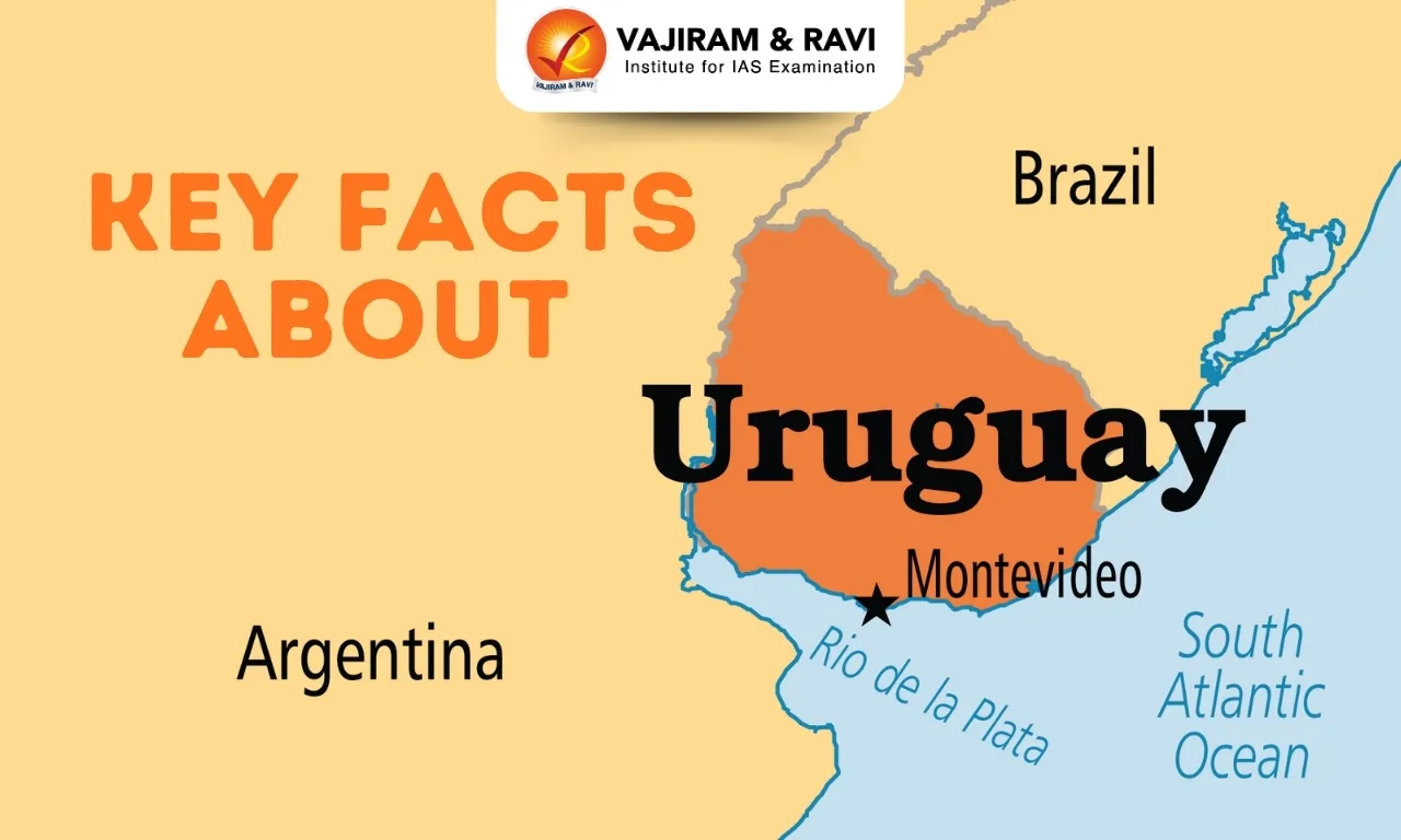
About Uruguay

  • It is a country located on the southeastern coast of South America.
  • It is the only South American nation to be situated entirely south of the Tropic of Capricorn. Bordered by:  Argentina (west and southwest), Brazil (north and east); and by the South Atlantic Ocean to the southeast.

Geographical Features of Uruguay

  • Climate: It is characterized as a humid subtropical climate.
  • Terrain: It is influenced by the Pampas, these grasslands traditionally used for extensive livestock farming. It also consists of rolling plains, low plateaus, and hills.
  • It also consists of Haedo Ridge (Cuchilla de Haedo) in the north and Grande Ridge (Cuchilla Grande) in the southeast.
  • Major Rivers: Rio de la Plata/Parana River, Uruguay river (It forms the border between Uruguay and Argentina).
  • Uruguay's coast is influenced by the Brazil Current (warm, northward) and Malvinas (Falkland) Current.
  • Highest Point: Mount Catedral
  • Capital city: Montevideo

Source: TH

Uruguay FAQs

Q1: What is the capital of Uruguay?

Ans: Montevideo

Q2: Which countries share a border with Uruguay?

Ans: Argentina and Brazil

Lagocheilus hayaomiyazakii

Lagocheilus hayaomiyazakii

Lagocheilus hayaomiyazakii Latest News

Researchers from the Thackeray Wildlife Foundation recently discovered a new species of snail named Lagocheilus hayaomiyazakii, also known as Tilari hairy snail.

About Lagocheilus hayaomiyazakii

  • It is a new species of hairy snail.
  • It was found in the evergreen Tilari forest region of Kolhapur district, Maharashtra.
  • It is found in leafy thickets and rocks of forests in the Western Ghats. 
  • It is named after Hayao Miyazaki, the legendary Japanese animator, filmmaker, and co-founder of Studio Ghibli, whose films beautifully capture the connection between humans and nature.
  • Lagocheilus hayaomiyazakii is the first record of the genus Lagocheilus from the northern Western Ghats, extending its known distribution range by 540 km north into the Indian Peninsula. 
  • The habitat of these snails is very limited. Due to wildfires and deforestation, their habitat is threatened, and they are likely to become extinct.

Source: TOI

Lagocheilus hayaomiyazakii FAQs

Q1: What is Lagocheilus hayaomiyazakii?

Ans: A new species of hairy snail.

Q2: In which region was Lagocheilus hayaomiyazakii discovered?

Ans: Tilari forest region, Kolhapur district, Maharashtra.

Q3: Lagocheilus hayaomiyazakii is named after which famous personality?

Ans: It is named after Hayao Miyazaki, the legendary Japanese animator, filmmaker, and co-founder of Studio Ghibli.

Q4: The discovery of Lagocheilus hayaomiyazakii marks the first record of the genus Lagocheilus from which region?

Ans: Northern Western Ghats

Exercise Samudra Shakti

Exercise Samudra Shakti

Exercise Samudra Shakti Latest News

The Indian Navy is hosting the fifth edition of Exercise, 'Samudra Shakti – 2025'  at Visakhapatnam.

About Exercise Samudra Shakti

  • It is a joint bilateral maritime exercise between India and Indonesia.
  • It is a key bilateral engagement aimed at enhancing interoperability, strengthening mutual understanding, and sharing best practices between the two navies.
  • It highlights the shared commitment of both nations towards maintaining stability and peace in the Indo-Pacific region.
  • India’s participation: The participating units include INS Kavaratti, an Anti-Submarine Warfare Corvette of the Eastern Fleet under the aegis of Eastern Naval Command (ENC). 
  • It consists of two phases
    • The harbour phase is aimed at building camaraderie and professional rapport that include Cross Deck Visits, Joint Yoga sessions, Friendly Sports fixtures, Professional Subject Matter Expert Exchanges (SMEE).
    • The Sea Phase will involve dynamic and complex maritime operations aimed at increasing tactical coordination, including Helicopter Operations, Air Defence Exercises, Weapon Firing Drills, Visit, Board, Search and Seizure (VBSS) exercises.
  • Other Exercises with Indonesia

Source: PIB

Exercise Samudra Shakti FAQs

Q1: What is Exercise Samudra Shakti?

Ans: A bilateral naval exercise between India and Indonesia.

Q2: What is the primary purpose of Exercise Samudra Shakti?

Ans: To enhance interoperability and cooperation between navies.

SAIME Initiative

SAIME Initiative

SAIME Initiative Latest News

Recently, a model of Sustainable Aquaculture in Mangrove Ecosystems (SAIME) in West Bengal’s Sundarbans has been conferred Global Technical Recognition by the Food and Agriculture Organization (FAO) of the United Nations.

About SAIME Initiative

  • The Sustainable Aquaculture in Mangrove Ecosystems (SAIME) is a multi-stakeholder partnership (MSP) to strengthen transformative processes in shrimp trade as a basis for the protection of mangrove ecosystems in West Bengal.
  • It is a climate-adaptive and conservation-linked livelihood initiative that integrates brackish water shrimp-based aquaculture with mangrove restoration.
  • It is an ecosystem-based, climate-adaptive, and conservation-linked livelihood approach.
  • Implemented by: It has been implemented in collaboration with Global Nature Fund (GNF), Nature Environment and Wildlife Society (NEWS), Naturland, and Bangladesh Environment & Development Society (BEDS),

What are Mangroves?

  • Mangroves are salt-tolerant trees and shrubs that grow in coastal intertidal zones, primarily in tropical and subtropical regions.

Characteristics of Mangroves

  • Salt Tolerance: They possess specialised root structures, such as salt-filtering roots and salt-excreting leaves, to manage high salinity levels.
  • Aerial Roots (Pneumatophores): These roots help in respiration by obtaining oxygen from the air in waterlogged soils.
  • Prop Roots: Provide stability against tidal waves and storm surges.
  • Vivipary (Seed Germination): Seeds germinate while still attached to the parent tree to overcome the challenge of germination in saline water.
  • Efficient Carbon Sequestration: Mangroves are among the most carbon-rich ecosystems, playing a vital role in mitigating climate change.
  • Ecological Significance: Mangrove forests act as a crucial buffer between land and sea, providing habitat for various marine and terrestrial species.

Source: TH

SAIME Initiative FAQs

Q1: Where is the SAIME initiative being implemented?

Ans: Sundarbans, West Bengal.

Q2: What is the main objective of the SAIME initiative?

Ans: To integrate mangrove conservation with sustainable aquaculture practices.

Military Combat Parachute System

Military Combat Parachute System

Military Combat Parachute System Latest News

Recently, the Defence Research and Development Organisation (DRDO) successfully tested the Military Combat Parachute System (MCPS) at 32,000 feet altitude.

About Military Combat Parachute System

  • It is indigenously developed by the Defence Research and Development Organisation (DRDO).
  • Organizations involved: It has been designed by DRDO’s Aerial Delivery Research and Development Establishment, Agra, and Defence Bioengineering and Electromedical Laboratory, Bengaluru.

Features of Military Combat Parachute System

  • It has successfully undergone a combat freefall jump from an altitude of 32,000 feet.
  • It is the only parachute system currently in operational use by the Indian Armed Forces capable of deployment above 25,000 feet.
  • It consists of several enhanced tactical features, including a lower rate of descent and superior steering capabilities.
  • The system has compatibility with Navigation with Indian Constellation (NavIC),

Significance of Military Combat Parachute System

  • It enables paratroopers to safely exit aircraft, deploy parachutes at predetermined altitudes, navigate accurately, and land at designated zones.
  • It also provides the freedom of use against any adversary of our choice and is not susceptible to interference/denial of service by outside parties/nations.
  • It has opened doors for induction of Indigenous parachute systems.
  • This will also reduce dependency on other nations for its serviceability during times of conflict and war.

Source: PIB

Military Combat Parachute System FAQs

Q1: What is the primary purpose of a Military Combat Parachute System?

Ans: To deploy troops into combat zones.

Q2: What is the primary objective of DRDO?

Ans: To achieve self-reliance in critical defence technologies.

Silent Valley National Park

Silent Valley National Park

Silent Valley National Park Latest News

Six new species of dragonflies and damselflies were found in Silent Valley National Park during an odonate survey held recently.

About Silent Valley National Park

  • It is a stretch of pristine wet evergreen forest located along the southwest corner of the Nilgiris in South India, in the State of Kerala.
  • It is one of the last undisturbed tracts of tropical rainforest in India. 
  • It constitutes the centerpiece of the Nilgiri Biosphere Reserve, sanctified as a World Heritage Site by UNESCO in 2012.
  • It covers an area of approximately 237.52 sq.km.
  • The altitude of the park varies between 658 to 2383 meters. 
  • It is nourished by the Kunthipuzha River, which meanders through the dense forest.
  • The valley is said to be "silent" because of the absence of the cicadas, a type of insect that produces a loud buzzing sound in many forests.
  • Vegetation: It has four types of vegetation "West Coast tropical evergreen forest, southern sub-tropical broad-leaved hill forest, montane wet temperature forest, and grasslands.
  • The park's dense forests, riverine ecosystems, and high-altitude grasslands provide a habitat for a variety of species, many of which are endemic to the Western Ghats.
  • Flora
    • The flora of the valley includes about 1000 species of flowering plants, 107 species of orchids, 100 ferns and fern allies, 200 liverworts, 75 lichens, and about 200 algae.
    • Plants of high medicinal value as well as the towering Culinea trees are also found here. 
  • Fauna:  
    • The park is famous for its population of lion-tailed macaques, an endangered primate species that is endemic to the Western Ghats. 
    • Other notable mammals include the Nilgiri langur, Malabar giant squirrel, Indian elephant, tiger, leopard, and gaur (Indian bison).
    • The park is also home to over 200 species of birds, including the great Indian hornbill, Nilgiri wood pigeon, and several species of eagles and owls.

Source: TH

Silent Valley National Park FAQs

Q1: Where is the Silent Valley National Park located?

Ans: Kerala

Q2: Silent Valley National Park lies along which geographical region?

Ans: Southwest corner of the Nilgiris in South India.

Q3: What type of forest is mainly found in Silent Valley National Park?

Ans: Tropical wet evergreen forest.

Q4: Which river nourishes the Silent Valley National Park?

Ans: Kunthipuzha River.

Q5: Why is the valley called “Silent Valley”?

Ans: Because of the absence of cicadas that make buzzing sounds

National Energy Conservation Award

National Energy Conservation Award

National Energy Conservation Awards Latest News

Recently, the Bureau of Energy Efficiency (BEE) has invited applications for the 35th National Energy Conservation Awards (NECA) 2025.

About National Energy Conservation Awards

  • It is one of the most prestigious national platforms that recognize excellence, innovation, and leadership in energy efficiency and conservation.
  • It was instituted in 1991 by the Bureau of Energy Efficiency (BEE).
  • Objective: These awards are envisioned to honor the exemplary contributions of industries, buildings, transport undertakings, and institutions in reducing energy consumption and enhancing energy efficiency.
  • Purpose and Significance -The Awards aim to inspire industries, organizations, and individuals to adopt energy-efficient technologies and practices.
  • Award Categories for NECA 2025: Industries, Transport, Buildings, Institutions (State/SDA - Evaluation through State EE Index), Energy-Efficient Appliances, Energy Efficiency Innovation, Content Creators and Influencers (New Category)
    • The new category, Digital Content Creators and Influencers, recognises the growing influence of social media in shaping public behavior and spreading awareness about energy conservation.
    • This new initiative aims to mobilize content creators as ambassadors of change, inspiring millions of citizens to adopt energy-conscious lifestyles. 

What is the Bureau of Energy Efficiency (BEE)?

  • It was set up on March 1, 2002 under the provisions of the Energy Conservation Act, 2001. 
  • Mission: To assist in developing policies and strategies with a thrust on self-regulation and market principles, within the overall framework of the Energy Conservation Act, 2001
  • Objective: The primary objective of reducing the energy intensity of the Indian economy. 
  • Functions: It coordinates with designated consumers, designated agencies and other organizations and recognises, identifies and utilises the existing resources and infrastructure, in performing the functions assigned to it under the Energy Conservation Act.

Source: PIB

National Energy Conservation Awards FAQs

Q1: What is the primary objective of the National Energy Conservation Awards?

Ans: To recognize and honor energy-efficient practices.

Q2: Which organization presents the National Energy Conservation Awards?

Ans: Bureau of Energy Efficiency (BEE).

National Environmental Engineering Research Institute (NEERI)

National Environmental Engineering Research Institute (NEERI)

National Environmental Engineering Research Institute (NEERI) Latest News

The Supreme Court recently permitted the limited use of green crackers approved by the National Environmental Engineering Research Institute (NEERI) in Delhi-NCR this Diwali.

About National Environmental Engineering Research Institute 

  • It is a research institute created and funded by the Government of India. 
  • NEERI is a pioneer laboratory in the field of environmental science and engineering.
  • The institute’s primary mission is to conduct research and development activities related to various aspects of environmental management, pollution control, and sustainable development.
  • Formation: 
    • It was established in Nagpur in 1958 as the Central Public Health Engineering Research Institute (CPHERI), when environmental concerns were limited to human health with a focus on water supply/sewage disposal/communicable diseases, and to some extent, on industrial pollution and occupational diseases. 
    • Slowly worldwide public awareness on the contamination of the environment on a regional to global scale started getting attention in the 1970’s. 
    • In 1974, CPHERI was rechristened the National Environmental Engineering Research Institute (NEERI).
  • It is a constituent laboratory of the Council of Scientific and Industrial Research (CSIR) under the Ministry of Science and Technology, Government of India. 
  • It is devoted to research and innovations in environmental science and engineering besides solving a range of problems posed by industry, government, and the public. 
  • Headquarters: Nagpur
  • NEERI has five zonal laboratories at Chennai, Delhi, Hyderabad, Kolkata and Mumbai.

Source: BT

National Environmental Engineering Research Institute (NEERI) FAQs

Q1: What is the National Environmental Engineering Research Institute (NEERI)?

Ans: A constituent laboratory of Council of Scientific and Industrial Research (CSIR) engaged in environmental research.

Q2: Where is the headquarters of National Environmental Engineering Research Institute (NEERI) located?

Ans: Nagpur

Q3: Under which ministry does National Environmental Engineering Research Institute (NEERI) function?

Ans: Ministry of Science and Technology, Government of India.

Q4: What is the main objective of National Environmental Engineering Research Institute (NEERI)?

Ans: To conduct research in environmental management and pollution control.

Madagascar

Madagascar

Madagascar Latest News

An elite military unit that backed youth-led anti-government street protests recently said it had taken power in Madagascar after the national assembly voted to impeach President Andry Rajoelina.

About Madagascar

  • It is an island country of Africa.
  • It is located around 400 km off the coast of East Africa in the Indian Ocean, with the nearest mainland African country being Mozambique. 
  • It is separated from the African coast by the Mozambique Channel.
  • It is the second-largest island country in the world. It covers an area of 592,800 sq.km.
  • The island country of Mauritius and Réunion (territory of France), lie to the east of Madagascar. 
  • To the northwest are the French territory of Mayotte and the island country of Comoros. 
  • The Tsaratanana Massif region at the northern end of the island is home to Madagascar’s highest point, Maromokotro, at 2,876 m. 
  • History:
    • France invaded the island in 1883. France officially declared Madagascar a French colony in 1896.
    • After World War II, in 1947, locals fought for their independence from France in what became known as the Malagasy Uprising. 
    • In 1960, Madagascar finally became an independent nation.
  • Capital: Antananarivo
  • Languages: Malagasy, French
  • Government: It is a semi-presidential republic. The public elects a president, who in turn appoints a prime minister to put together a cabinet to advise the president. 
  • Economy
    • Eighty percent of Madagascar’s economy is fueled by agricultural industries, including forestry and fishing. 
    • Among the island’s most frequently sold agricultural products are coffee, vanilla, and sugarcane.
  • Biodiversity:
    • Lush rainforests, dry deserts, and grassy plains cover the island, with coral reefs and mangrove forests stretching along its coastlines. 
    • Almost 90 percent of the plants and animals living on Madagascar aren’t found anywhere else in the world.
    • That’s because strong ocean currents have isolated the island from the African continent, so the species living there haven’t traveled beyond the island’s borders.

Source: NDTV

Madagascar FAQs

Q1: Madagascar is an island country belonging to which continent?

Ans: Africa

Q2: Which channel separates Madagascar from mainland Africa?

Ans: Mozambique Channel

Q3: Which African country lies closest to Madagascar?

Ans: Mozambique

Q4: What is the capital of Madagascar?

Ans: Antananarivo

Akash Missile System

Akash Missile System

Akash Missile System Latest News

India is learnt to have pitched for the supply of the Akash missile system to Brazil, as the Defence Minister recently held wide-ranging talks with Brazilian Vice-President Geraldo Alckmin in New Delhi.

About Akash Missile System

  • It is a short-range surface-to-air missile (SAM) system.
  • It is designed to protect vulnerable areas, points, and assets from a range of aerial threats, including fighter aircraft, cruise missiles, drones, and helicopters.
  • It was indigenously designed and developed by India’s Defence Research and Development Organisation (DRDO) and is produced by Hyderabad-based Bharat Dynamics Ltd. (BDL).
  • It is currently in service with the Indian Air Force (IAF) and the Indian Army. 

Akash Missile System Features

  • The system features a launcher, a missile, a control centre, an integral mission guidance system, a multifunctional fire control radar, a system arming and explosion mechanism, a digital autopilot, C4I (command, control, communication, and intelligence) centres and supporting ground equipment.
  • It can simultaneously engage multiple targets in Group Mode or Autonomous Mode.
  • The missile is 5.87 meters long, 350 millimeters in diameter, and weighs 710 kilograms.
  • It features a solid-fuel, ramjet propulsion system, capable of reaching speeds of Mach 2.5 to 3.5 (up to 4,200 km/h).
  • It covers a range of 4.5 km to 25 km and can engage aerial threats flying between 100 meters and 20 kilometers in altitude.
  • It is a fully mobile system, effective at engaging multiple targets simultaneously with a kill probability of up to 99% with a salvo of two missiles. 
  • Its sophisticated Rajendra radar can track numerous targets and guide multiple missiles concurrently.
  • It is fully automatic, features built-in electronic counter measures, and is mobile across different terrains.

Source: TH

Akash Missile System FAQs

Q1: What type of missile system is the Akash Missile System?

Ans: It is a short-range surface-to-air missile (SAM) system.

Q2: Which organisation designed and developed the Akash Missile System?

Ans: Defence Research and Development Organisation (DRDO)

Q3: What is the maximum range of the Akash Missile System?

Ans: It covers a range of 4.5 km to 25 km.

Q4: What is the maximum altitude at which the Akash missile can engage aerial threats?

Ans: 20 km

Enquire Now