Mount Bur Ni Telong

Mount Bur Ni Telong

Mount Bur Ni Telong Latest News

Indonesian authorities recently raised the alert for Mount Bur Ni Telong volcano due to increased activity, including numerous earthquakes

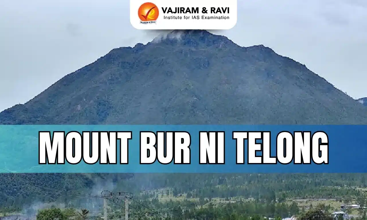
About Mount Bur Ni Telong

  • It is an active stratovolcano.
  • It is located in Indonesia’s westernmost province of Aceh.
  • It is one of the best climbing spots in Aceh.
  • The volcano stands at approximately 2,624 meters above sea level. 
  • The conical Bur ni Telong volcano was constructed at the southern base of the massive Bur ni Geureudong volcanic complex, one of the largest in northern Sumatra.
  • It is formed by multiple layers of lava and eruptive materials, making it prone to explosive eruptions and highly hazardous.

What is a Stratovolcano?

  • It is a tall, steep, and cone-shaped type of volcano.
  • Unlike flat shield volcanoes, they have higher peaks.
  • They are typically found above subduction zones, and they are often part of large volcanically active regions, such as the Ring of Fire that frames much of the Pacific Ocean.
  • Strato Volcanoes comprise the largest percentage (~60%) of the Earth’s individual volcanoes, and most are characterized by eruptions of andesite and dacite, lavas that are cooler and more viscous than basalt.
  • These more viscous lavas allow gas pressures to build up to high levels. Therefore, these volcanoes often suffer explosive eruptions. 
  • They are usually about half-half lava and pyroclastic material, and the layering of these products gives them their other common name of composite volcanoes.
  • At the peak, stratovolcanoes usually have a small crater. The crater may be filled with water or ice, or it may contain a volcanic dome during a period of relative inactivity.

Source: DEV

Mount Bur Ni Telong FAQs

Q1: What type of volcano is Mount Bur Ni Telong?

Ans: It is an active stratovolcano.

Q2: In which country is Mount Bur Ni Telong located?

Ans: It is located in Indonesia’s Aceh province.

Q3: What is the approximate elevation of Mount Bur Ni Telong above sea level?

Ans: About 2,624 meters.

Vishnugad Pipalkoti Hydro Electric Project (VPHEP)

Vishnugad Pipalkoti Hydro Electric Project

Vishnugad Pipalkoti Hydro Electric Project (VPHEP) Latest News

Around 60 people were injured after a loco train carrying workers and officials hit a goods train inside the Pipalkoti tunnel of the Vishnugad–Pipalkoti Hydroelectric Project recently.

About Vishnugad Pipalkoti Hydro Electric Project (VPHEP)

  • It is a run-of-river hydropower scheme being developed on the Alaknanda River (a major tributary of the Ganga River) in the Chamoli district of Uttarakhand.
  • With an installed capacity of 444 MW (4 × 111 MW) and a gross head of approximately 237 metres, VPHEP is designed to provide peaking power to India’s Northern Grid.
  • The project, when completed, will generate an estimated 1,665 gigawatt-hours (or million kilowatt-hours) of electricity in a typical year. 
  • The project includes a 65-meter diversion dam, a 13.4-km headrace tunnel, a 3-km tailrace tunnel, and an underground powerhouse. 
  • All water diverted from the river will be returned to the river approximately 18 km after the point of diversion. 
  • It is being developed by THDC India Ltd (formerly Tehri Hydro Development Corporation Limited) and financed by a US$ 648 million loan from the World Bank.
    • THDC is a joint venture between the government of India and the government of Uttar Pradesh.

Source: TOI

Vishnugad Pipalkoti Hydro Electric Project (VPHEP) FAQs

Q1: On which river is the Vishnugad Pipalkoti Hydro Electric Project being developed?

Ans: On the Alaknanda River, a major tributary of the Ganga.

Q2: What type of hydropower project is the Vishnugad Pipalkoti Hydro Electric Project?

Ans: A run-of-river hydropower scheme.

Q3: What is the total installed capacity of the Vishnugad Pipalkoti Hydro Electric Project?

Ans: 444 MW (4 × 111 MW).

Q4: Which agency is developing the Vishnugad Pipalkoti Hydro Electric Project?

Ans: It is being developed by THDC India Ltd (formerly Tehri Hydro Development Corporation Limited).

Land Stack

Land Stack

Land Stack Latest News

Recently, the Minister of State for Rural Development and Communications launched the ‘Land Stack’ in the Pilot Locations of Chandigarh and Tamil Nadu and released the ‘Glossary of Revenue Terms’ (GoRT).

About Land Stack

  • It is an integrated, GIS-based digital platform designed to consolidate all land records into a singular, accessible platform.
  • It is inspired by successful models in nations such as Singapore, the UK, and Finland. 
  • It was launched under the Digital India Land Record Modernisation Programme (DILRMP).

Benefits of Land Stack

  • The Land Stack portal enables informed decision-making by citizens through integrated access to land-related information.
  • It enhances citizen convenience, transparency and trust.
  • It reduces the risk of inadvertent purchase of unauthorised or non-compliant properties.
  • It improves inter-departmental coordination and supports data-driven governance.
  • It represents a significant e-Governance reform in land administration.

What is the Glossary of Revenue Terms?

  • It provides meanings of various land-related revenue terms in Vernacular, Hindi, English, and Roman scripts.
  • The objective is to harmonize terminology to make land data comparable and interoperable nationally, without replacing State-specific terminology.
  • It serves as an authoritative reference for revenue officials, policymakers, judicial authorities, and citizens.

Source: PIB

Land Stack FAQs

Q1: What is Land Stack?

Ans: A digital platform for land records management

Q2: Which government initiative is Land Stack a part of?

Ans: Digital India

District Mineral Foundations

District Mineral Foundations

District Mineral Foundations Latest News

The Allahabad High Court recently held that the formation of District Mineral Foundations is  beneficial legislation and must be construed liberally for those who are affected negatively by mining operations.

About District Mineral Foundations 

  • DMFs are statutory bodies in India established by the state governments by notification. 
  • They derive their legal status from Section 9B of the Mines and Minerals (Development and Regulation) Act, 1957, as amended on 26 March 2015 as the Mines and Minerals (Development and Regulation) Amendment Act, 2015.
  • In any district affected by mining-related operations, the State Government shall, by notification, establish a trust, as a non-profit body, to be called the DMF.
  • Purpose: To work in the interest and benefit of persons and areas affected by mining-related operations in a manner as may be prescribed by the respective State Government.
  • Jurisdiction:
    • The operation of DMFs falls under the jurisdiction of the relevant State Government. 
    • Composition and functions of the DMF are prescribed by the State Governments.
  • Funding: It is funded through the contributions from the holders of major or minor mineral concessions in the district, as may be prescribed by the Central or State Government.
  • The Central Government has notified the rates of contribution payable by miners to the DMFs.
    • In the case of all mining leases executed before 12th January, 2015, miners will have to contribute an amount equal to 30% of the royalty payable by them to the DMFs. 
    • If mining leases are granted after 12.01.2015, the rate of contribution would be 10% of the royalty payable.
  • The Fund available with the Trust shall be used for:
    • The overall development of the area affected by mining-related operations in the District in accordance with the Annual Action Plan prepared by the Trustees of the Foundation for the purpose.
    • Creation of local infrastructure for socio-economic purposes.
    • Providing, maintaining, or upgrading community assets and services for the local population in the area affected by mining-related operations.
    • Organising or conducting training programmes to skill development and capacity building for creating employment and self-employment capabilities.

Pradhan Mantri Khanij Kshetra Kalyan Yojana (PMKKKY)

  • The Ministry of Mines launched PMKKKY in 2015 for the welfare of areas and people affected by mining-related operations, using the funds generated by DMFs.
  • Objectives:
    • To implement various developmental and welfare projects in mining-affected areas, complementing the existing ongoing schemes of the State and Central Government.
    • To minimize/mitigate the adverse impacts, during and after mining, on the environment, health, and socio-economics of people in mining districts.
    • To ensure long-term sustainable livelihoods for the affected people in mining areas.
  • Utilisation of Funds:
    • At least 60% of PMKKKY funds to be utilized for high-priority areas such as Drinking water supply, Health care, Education, Environment preservation, etc.
    • Up to 40% of the PMKKKY to be utilized for other priority areas such as Physical infrastructure, Irrigation, Energy, and Watershed Development, etc.

Source: LL

District Mineral Foundations FAQs

Q1: Who establishes the District Mineral Foundations in mining-affected districts?

Ans: The State Government, by notification.

Q2: What type of body is a District Mineral Foundation?

Ans: A statutory, non-profit trust.

Q3: What is the primary purpose of a District Mineral Foundation?

Ans: To work for the interest and benefit of persons and areas affected by mining-related operations.

Q4: How are District Mineral Foundations funded?

Ans: Through contributions from holders of major or minor mineral concessions in the district.

Voice over WiFi

Voice over WiFi

Voice over WiFi Latest News

 Recently, the Bharat Sanchar Nigam Limited (BSNL) announced the nationwide rollout of Voice over WiFi (VoWiFi).

About Voice over WiFi

  • It is a technology that allows voice calls over Wi-Fi networks, bypassing traditional cellular networks.
  • It enables customers to make and receive voice calls and messages over a Wi-Fi network.
  • VoWiFi is an IP Multimedia Subsystem (IMS)-based service using the customer’s existing mobile number and phone dialer, without the need for third-party applications.
  • It is also known as Wi-Fi Calling.
  • Working of Voice over Wi-Fi: It works by utilizing Voice over Internet Protocol (VoIP) technology to transmit voice data as digital packets over an internet connection.
  • It's built directly into your phone's operating system and works seamlessly with your existing phone number and contacts.

Advantages of Voice over WiFi

  • It ensures clear and reliable connectivity in areas with weak mobile signal such as homes, offices, basements, and remote locations.
  • It helps reduce network congestion and is offered free of cost, with no additional charges for Wi-Fi calls.
  • It ensures clear and reliable connectivity in areas with weak mobile signals such as homes, offices, basements, and remote locations.

Source: PIB

Voice over WiFi FAQs

Q1: Which technology does VoWiFi use to transmit voice data?

Ans: Voice over Internet Protocol (VoIP) technology

Q2: What is the benefit of VoWiFi?

Ans: Better call quality in areas with poor cellular coverage

Cellulitis

Cellulitis

Cellulitis Latest News

An observational study about Cellulitis was published in the  International Journal of Lower Extremity Wounds. 

About Cellulitis

  • Cellulitis is a common skin infection caused mostly by streptococcus and staphylococcus bacteria.
  • Common Sites: It can affect the tissues beneath the skin and can affect any part of the body such as the face, arms, hands and fingers it usually affects the legs, feet and toes.
  • Risk factor: Anyone can contract cellulitis, but persons with skin wounds, or compromised immune systems, which allows the bacteria to enter easily, are at higher risk.
  • Cellulitis is not contagious but in rare cases if you have an open wound and have skin-to-skin contact with an infected person’s open wound.

Symptoms of Cellulitis

  • Infected skin may appear slightly discoloured, and warm to touch. As the infection spreads, the discolouration darkens and the skin swells and becomes tender.
  • A person could have fever, feel fatigued, experience chills, develop spots on the skin, blisters filled with fluid and dimpling of the skin. 
  • Treatment: It usually consists of a course of oral antibiotics. Severe cases may need hospitalisation and IV antibiotics.

Source: TH

Cellulitis FAQs

Q1: What is the most common cause of Cellulitis?

Ans: Bacterial infection (Streptococcus and Staphylococcus)

Q2: What is a common symptom of Cellulitis?

Ans: Redness and warmth of skin

Skilling for AI Readiness (SOAR) Programme

Skilling for AI Readiness (SOAR) Programme

Skilling for AI Readiness (SOAR) Programme Latest News

Recently, the President of India graced a special programme under SOAR initiative.

About Skilling for AI Readiness (SOAR) Programme

  • It is an initiative of the Ministry of Skill Development and Entrepreneurship (MSDE).
  • Aim: It aims to integrate artificial intelligence learning into India’s school education and training ecosystem, preparing both students and teachers for a rapidly evolving digital world.
  • It has a vision to position India as a global leader in AI by preparing its youth for AI-driven careers and entrepreneurial ventures.

Features of Skilling for AI Readiness (SOAR) Programme

  • Target: It focuses on school students from classes 6 to 12 and educators across India.
  • Course: It offers three targeted 15-hour modules for students and a 45-hour module for teachers.
  • These courses introduce foundational AI and machine learning concepts, along with data literacy and the ethical use of technology.
  • Funding: To this government provided ₹500 crore to establish a Centre of Excellence in Artificial Intelligence for Education.
    • The centre will focus on developing AI-based learning tools, promoting multilingual AI resources for Indian languages, and fostering innovative classroom practices.
    • It will also strengthen AI curriculum development across technical institutions and complement existing efforts by IITs and AICTE-approved colleges that already offer advanced courses in machine learning, deep learning, and data analytics.

Source: PIB

Skilling for AI Readiness (SOAR) Programme FAQs

Q1: What is the primary objective of the Skilling for AI Readiness (SOAR) Programme?

Ans: To equip students and educators with AI skills

Q2: Which ministry launched the SOAR Programme?

Ans: Ministry of Skill Development and Entrepreneurship

Eastern Imperial Eagle

Eastern Imperial Eagle

Eastern Imperial Eagle

Wildlife enthusiasts recently confirmed the presence of an Eastern Imperial Eagle visiting the Mudumalai Tiger Reserve (MTR) during the winter migratory season.

About Eastern Imperial Eagle

  • It is a large bird of prey.
  • Scientific Name: Aquila heliaca

Eastern Imperial Eagle Distribution

  • It breeds in southeastern Europe and extensively through West and Central Asia. 
  • Most populations are migratory and winter in northeastern Africa, the Middle East and South and East Asia.
  • Like all eagles, the eastern imperial eagle is a member of the family Accipitridae. Furthermore, its well feathered legs mark it as a member of the subfamily Aquilinae.

Eastern Imperial Eagle Features

  • It is the second largest eagle to reside in Europe. It can grow to a length of about 0.92 meters. 
  • It can have a wingspan approaching 2.14 meters and have a mass of about 3.6 kilograms. 
  • The species displays reverse sexual dimorphism, as do most birds of prey, in which males are usually smaller than the females.
  • Adults are black-brown in color. They have a pale golden crown and nape and a grey base that extends to the tail. 
  • Like other eagles, they have strong legs and feet. Their feet include long, curved talons that they use to seize, kill, and carry their prey.
  • Average lifespan: 56 years

Eastern Imperial Eagle Conservation Status

It is classified as 'Vulnerable' under the IUCN Red List.

Mudumalai Tiger Reserve (MTR)

  • It is located in the Nilgiris District of Tamil Nadu, spread over 321 sq. km. at the tri-junction of three states, viz., Karnataka, Kerala, and Tamil Nadu.
  • It lies on the northeastern and northwestern slopes of the Nilgiri hills, which is a part of the Western Ghats.
  • It is part of the Nilgiris Biosphere Reserve, the first biosphere reserve in India.
  • The name Mudumalai means ”the ancient hill range”. Indeed, it is as old as 65 million years, when the Western Ghats were formed.
  • Habitat: A variety of habitats ranging from tropical evergreen forest, moist deciduous forest, moist teak forest, dry teak forest, secondary grasslands, and swamps are found here.
  • River: The Moyar River runs through the reserve.
  • The Oscar-winning ‘Elephant Whisperers’ was filmed at the Theppakadu Elephant Camp, located inside the Mudumalai Tiger Reserve.
  • Flora:
    • It has tall grasses, commonly referred to as “Elephant Grass”, bamboo of the giant variety, and valuable timber species like teak, rosewood, etc.
    • It has wild relatives of cultivated plants, viz., wild rice, ginger, turmeric, cinnamon, etc.
    • The habitat also has swampy areas (Vayals) and grasslands.
  • Fauna:
    • The faunal assemblage includes: elephant, gaur, sambar, four-horned antelope, spotted deer, barking deer, blackbuck, wild pig, mouse deer, and predators like tigers, leopards, and wild dogs.
    • Around 8% of the total bird species in India can be found in the region.

Source: TH

Eastern Imperial Eagle FAQs

Q1: Where does the Eastern Imperial Eagle primarily breed?

Ans: It breeds in southeastern Europe and extensively through West and Central Asia.

Q2: Where do most populations of the Eastern Imperial Eagle winter?

Ans: They winter in northeastern Africa, the Middle East, and South and East Asia.

Q3: What are the typical colours of the adult Eastern Imperial Eagle?

Ans: Adults are black-brown with a pale golden crown and nape and a grey base extending to the tail.

Q4: What is the IUCN Red List status of the Eastern Imperial Eagle?

Ans: Vulnerable

Venezuela

Venezuela

Venezuela Latest News

Recently, the U.S. military has launched large-scale strikes inside Venezuela, with explosions heard in multiple areas, including the capital Caracas.

About Venezuela

  • Location: It is located on the northern coast of South America.
  • Bordering Countries: It is bounded by Guyana to the east, Brazil to the south, and Colombia to the southwest and west. 
  • Maritime boundaries: It shares a border with the Caribbean Sea and the Atlantic Ocean to the north.
  • Capital: Caracas.

Geographical Features of Venezuela

  • Terrain: Andes Mountains and Maracaibo Lowlands in northwest; central plains (llanos); Guiana Highlands in southeast
  • Major Rivers: Rio Negro (shared with Colombia and Brazil) and Orinoco (shared with Colombia).
  • Major Lakes:  Lake Guri and Lake Maracaibo (the largest lake in South America).
  • Highest Point: Pico Bolivar 
  • The world’s highest waterfall – the Andes Mountains Angel Falls is located in the Guiana Highlands.
  • Natural Resources: It is home to the world’s largest oil reserves as well as huge quantities of coal, iron ore, bauxite, and gold.

Source: IE

Venezuela FAQs

Q1: Where is Venezuela located?

Ans: South America

Q2: What is the capital of Venezuela?

Ans: Caracas

Car Nicobar Island

Car Nicobar Island

Car Nicobar Island Latest News

The Chief of Defence Staff recently inaugurated a major runway upgrade at the Indian Air Force’s Car Nicobar air base.

About Car Nicobar Island

  • It is part of the Nicobar district in the Andaman and Nicobar Islands Union Territory.
  • It is the northernmost island of the Nicobar group. 
  • It lies south of Little Andaman and north of Nancowry Island.
  • The ten-degree channel lies on the northern side of the island and separates the Andaman Islands and Nicobar Islands.
  • Despite being a small island – under 127 sq.km. – it holds nearly half of Nicobar’s population (over 17,800 in 2011) and serves as the district headquarters.
  • It is remarkably flat except for some cliffs in the north and small hilly areas in the interior. 
  • It is bordered by a silvery beach and areas of flat ground consisting of coraline diluvium.
  • It is inhabited primarily by the Nicobarese tribal community (Scheduled Tribe).
  • The climate of Car Nicobar Island is a tropical monsoon climate, as it is just 9 degrees from the equator, with an annual rainfall of 400 mm.
  • The Car Nicobar islands do not have any evergreen forests, which dominate the central and southern islands of the Nicobars. 
  • Most of the island is covered with coconut plantations, and natural flora is present only in the interior areas.
  • The island has been designated an Important Bird Area (IBA) by BirdLife International.
  • The island was severely affected by the tsunami that was caused by the 2004 Indian Ocean earthquake, which led to many deaths and damaged infrastructure.
    • Car Nicobar lies 750 km (470 mi) from the epicenter of the 2004 Indian Ocean earthquake, and the ensuing tsunamis struck it with great force.

Source: TOI

Car Nicobar Island FAQs

Q1: Which is the northernmost island of the Nicobar group?

Ans: Car Nicobar Island.

Q2: Which islands lie north and south of Car Nicobar Island?

Ans: Little Andaman lies to the north, and Nancowry Island lies to the south.

Q3: What is the main tribal community inhabiting Car Nicobar?

Ans: It is inhabited primarily by the Nicobarese tribal community.

Q4: What is the general topography of Car Nicobar Island?

Ans: It is remarkably flat, with some cliffs in the north and small hilly interior areas.

Q5: What type of climate does Car Nicobar Island experience?

Ans: A tropical monsoon climate.

Galaxy Frog

Galaxy Frog

Galaxy Frog Latest News

According to the study, a group of seven galaxy frogs vanished, all likely to be dead, after multiple photographers descended on their habitat.

About Galaxy Frog

  • Galaxy frogs (Melanobatrachus indicus) are one of the rarest and most dazzling amphibians in the world.
  • The frog belongs to the family Microhylidae and sub-family Melanobatrachinae.
    • Its dorsal region is warty and speckled with bluish-white spots that resemble stars in the night sky, hence the name 'Galaxy frog'.
  • It has been declared the flagship species of Mathikettan Shola National Park in Idukki , Kerala
  • Appearance: It measures just 2 centimetres-3.5 centimetres and has shiny black skin dotted with pale blue speckles, resembling a clear night sky studded with stars.
  • Habitat: It nestles under logs and stones on the forest floor at elevations above 900 metres.
  • Distribution:  It is endemic to wet evergreen forests of southern Western Ghats in Kerala and Tamil Nadu states of India.
  • Conservation Status: IUCN Red List: Vulnerable 

Characteristics of Galaxy Frog

  • Unlike other frogs, the Galaxy Frog doesn’t have a vocal sac and hence it can’t be identified through its calls.
  • The bright-coloured spots are being inferred to aid the frog in communication.
  • It is a nocturnal species and extremely sensitive to light
  • It absorbs water and oxygen through their skin, so moist air is a must for this species. 
  • They keep their skin moist by secreting a slimy secretion called mucus to breathe through the skin.
  • Threats: Major threats to these creatures are the conversion of forest areas to farm land, firewood collection and landslide and Photo tourism has emerged as a new danger to galaxy frogs.

Source: IE

Galaxy Frog FAQs

Q1: What is the conservation status of the Galaxy Frog?

Ans: Vulnerable

Q2: Where is the Galaxy Frog primarily found?

Ans: Western Ghats

Enquire Now