Rapti River

Rapti River

Rapti River Latest News

The National Green Tribunal (NGT) has directed the Uttar Pradesh government to correct official records and restore the Suav, a major tributary of the Rapti river status from a “drain” to a “river” in the revenue records and gazetteer.
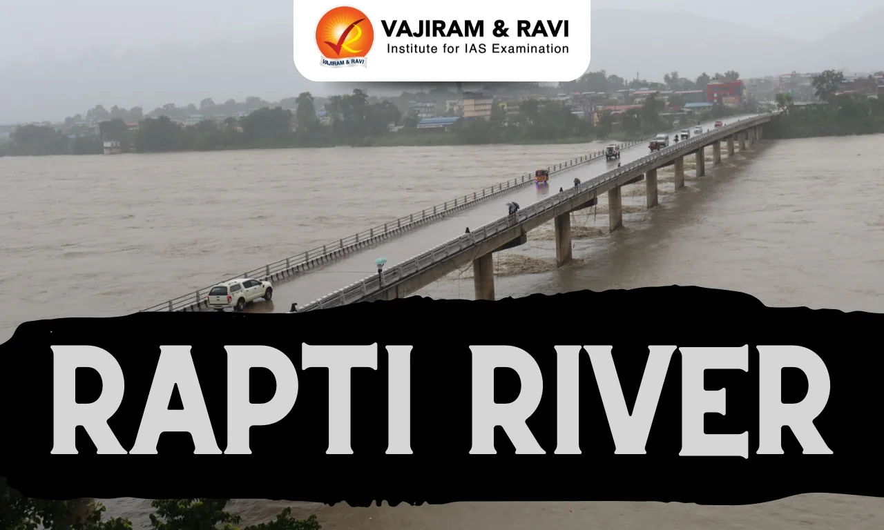
About Rapti River

  • Rapti River is the most important left bank tributary of the Ghaghra River.
  • Historically, the Rapti River was known as Iravati.
  • Origin: The Rapti River originates in Nepal near Rukumkot in the Mahabharat range of the lesser Himalayas.
  • The river begins in Nepal's Mahabharat range at an elevation of 3,050 metres.
  • Topography: The entire basin's topography is made up of lofty mountains, inner and outer Tarai, and undulating plain regions.
  • It has two distinct climatic regions due to altitude differences: the mountainous region has a temperate climate, while the plain region has a subtropical climate.
  • Burhi Rapti and Rohini are the major left bank tributaries of Rapti.
  • After flowing through Nepal, it enters Eastern Uttar Pradesh.

Key Facts about National Green Tribunal

  • It has been established under the National Green Tribunal Act, 2010.
  • It is a specialized body equipped with the necessary expertise to handle environmental disputes involving multi-disciplinary issues.
  • It shall be guided by principles of natural justice.
  • Mandate: The Tribunal is mandated to make and endeavour for disposal of applications or appeals finally within 6 months of filing of the case.
  • Locations: New Delhi is the Principal Place of Sitting of the Tribunal and Bhopal, Pune, Kolkata and Chennai shall be the other four place of sitting of the Tribunal.

Composition of NGT

  • Chairperson: A retired Supreme Court judge.
  • Judicial members: Retired High Court judges.
  • Expert members: Professionals with at least 15 years of experience in fields related to environment or forest conservation.

Source: DTE

Rapti River FAQs

Q1: Where is the Rapti River located?

Ans: Flows through Nepal and India

Q2: Where does the river Rapti come from?

Ans: It rises in Nepal at an elevation of about 3048 m. in the Dregaunra range.

Takeshima

Takeshima

Takeshima Latest News

South Korea recently protested a Japanese government-backed “Takeshima Day” event, calling it an unjust assertion of sovereignty over disputed islands also claimed by Japan.

About Takeshima

  • It is a group of small islets situated in the middle of the Sea of Japan.
  • It is lying almost equidistant between the Korean Peninsula and Japan.
  • It is called Dokdo in South Korea and Takeshima in Japan.
  • It has also been known as the Liancourt Rocks, named by French whalers after their ship in 1849.
  • The islands themselves consist of two main islands and about 30 smaller rocks.
  • Administrative Control:
    • South Korea currently administers the islets, maintaining a small police detachment and facilities.
    • Japan claims sovereignty and considers the issue an unresolved territorial dispute.

Key Facts about the Sea of Japan 

  • The Sea of Japan, or East Sea, is a marginal sea of the western Pacific Ocean.
  • It is bound by Japan and Sakhalin to the east and by mainland Russia, North Korea, and South Korea to the west.
  • Connections:
    • It is connected with the East China Sea via the Tsushima and Korea straits and with the Okhotsk Sea in the north by the La Perouse and Tatar straits.
    • In the east, it is connected with the Inland Sea of Japan via the Kanmon Strait and the Pacific Ocean by the Tsugaru Strait.
  • Dohoku Seamount, an underwater volcano, is its deepest point.
  • Tides: Like the Mediterranean Sea, it has almost no tides due to its nearly complete enclosure from the Pacific Ocean. 
  • Major Ports:
    • Russia: Vladivostok, Sovetskaya Gavan, Nakhodka, Alexandrovsk-Sakhalinsky, and Kholmsk. 
    • North Korea: Hamhung, Chongjin, and Wonsan.
    • Japan: Niigata, Tsuruta, and Maizuru.

Source: FP

Takeshima FAQs

Q1: Where is Takeshima located?

Ans: It is located in the Sea of Japan (East Sea), almost equidistant between the Korean Peninsula and Japan.

Q2: How many main islands make up Takeshima?

Ans: It consists of two main islands and about 30 smaller rocks.

Q3: Which country currently administers Takeshima?

Ans: South Korea currently administers the islets.

Kole Wetlands

Kole Wetlands

Kole Wetlands Latest News

A recent scientific study conducted at the Kole wetlands, a Ramsar-listed ecosystem in Kerala, has documented a total of 12 species of pygmy grasshoppers.

About Kole Wetlands

  • The Kole wetlands are located in Central Kerala, that spreads over Thrissur and Malappuram districts. 
  • It is popular for its paddy cultivation that dates back to 300 years. 
  • The wetland gets its name from its high productivity – ‘Kole’ literally translates to ‘bumper crop’ in Malayalam.
  • The Kole areas are low-lying and have a central, narrow strip covering a long expanse, with many pockets running into cultivated land on either side.
  • The region is naturally subject to saltwater ingression. During the monsoon, the entire region, which gets submerged under water, is cultivated by draining the water and by erecting bunds. 
  • As Kole is a large sprawling wetland with human habitation all around, there are coconut and arecanut plantations, gardens, and cultivated plants.
  • It is one of largest, highly productive, and threatened wetlands in Kerala. 
  • It comes in the Central Asian Flyway of migratory birds. 
  • In terms of the number of birds, the Kole Wetlands is the third largest in India after Chilika Lake in Orissa and Amipur Tank in Gujarat. 
  • It has been recognised as one of India's Important Bird Areas by BirdLife International.
  • It was declared as a Ramsar site of international importance in 2002.

What are Pygmy Grasshoppers?

  • They are any of about 1,400 species of insects (order Orthoptera) that are small (about 15 mm [0.6 inch] long), brown, gray, or moss-green, and related to true grasshoppers. 
  • However, the pygmy grasshopper has the forewings either reduced to small pads or absent. 
  • The pygmy grasshopper is distinguished from the short-horned grasshopper by its practice of depositing its eggs singly in small grooves in the soil, rather than in underground chambers. 
  • It is abundant in fields containing short grasses and on muddy shores. 
  • Many species are dimorphic, having both a short form with reduced hindwings and a long form with functional hindwings. 
  • Sound-producing and hearing organs are absent in pygmy grasshoppers.

Source: TH

Kole Wetlands FAQs

Q1: Where are the Kole Wetlands located?

Ans: They are located in central Kerala, spread across Thrissur and Malappuram districts.

Q2: What type of agriculture is the Kole Wetlands known for?

Ans: It is known for paddy cultivation dating back about 300 years.

Q3: What is the topographical nature of the Kole Wetlands?

Ans: They are low-lying wetlands with a narrow central strip and pockets extending into cultivated lands.

Q4: When was the Kole Wetlands designated as a Ramsar site?

Ans: It was declared a Ramsar site of international importance in 2002.

Sayyad-3G Missile

Sayyad-3G Missile

Sayyad-3G Missile Latest News

  • Iran’s Islamic Revolutionary Guard Corps (IRGC) Navy recently tested the Sayyad-3G air defense missile.

About Sayyad-3G Missile

  • It is a naval surface-to-air defense missile developed by Iran.
  • Derived from the land-based Sayyad-3 missile, the Sayyad-3G has been adapted for maritime use, providing medium-range air defense for warships and naval vessels. 
  • It is launched from ships via a Vertical Launch System (VLS), offering 360-degree coverage and rapid response against aerial threats.
  • The missile is capable of intercepting multiple airborne targets, including warplanes, maritime patrol aircraft, and high-altitude UAVs. 
  • It can operate both independently and as part of an integrated naval command-and-control network, using the ship’s onboard radar while retaining autonomous tracking and targeting capability.
  • Its operational range is reported to be approximately 150 kilometers.

Source: OI

Sayyad-3G Missile FAQs

Q1: Which country has developed the Sayyad-3G missile?

Ans: Iran

Q2: What type of missile is the Sayyad-3G?

Ans: It is a naval surface-to-air defense missile.

Q3: What types of targets can the Sayyad-3G intercept?

Ans: It can intercept warplanes, maritime patrol aircraft, and high-altitude UAVs.

Q4: What is the operational range of the Sayyad-3G missile?

Ans: Its operational range is reported to be approximately 150 kilometers.

Apple Cultivation

Apple Cultivation

Apple Cultivation Latest News

According to the J&K Economic Survey 2025-26, apple production comprises 50% of the total horticulture production of J&K against pear, apricot, peach, plum, cherry, citrus, mango, walnut, almond etc. 

About Apple Cultivation

  • Apple (Malus pumila) is an important temperate fruit.
  • Climatic conditions required For Apple
    • Temperature: The average summer temperature should be around 21-24 degrees C during the active growth period.
    • It can be grown at an altitude of 1500- 2700 m above sea level.
    • Rainfall: Well-distributed rainfall of 1000-1250 mm throughout the growing season is most favourable for the optimum growth and fruitfulness of apple trees.
    • Soil: Apples grow best on well-drained, loamy soils.
  • Apple growing States in India:
    • In India apple is primarily cultivated in Jammu & Kashmir; Himachal Pradesh; the hills of Uttar Pradesh and Uttaranchal.
    • It is also cultivated to a small extent in Arunachal Pradesh; Nagaland; Punjab and Sikkim.

Source: TH

Apple Cultivation FAQs

Q1: What is the ideal temperature range for apple cultivation?

Ans: 15-25°C

Q2: Apples typically require how many chill hours?

Ans: 500-1000 hours

Vaan Island

Vaan Island

Vaan Island Latest News

A decade-long artificial reef restoration of Vaan Island generated socio-ecological benefits worth ₹61.67 crore—over twice its inflation-adjusted cost, according to a technical assessment by the Tamil Nadu Coastal Restoration Mission and its partners.

About Vaan Island

  • Vaan is one of the 21 islands in the Gulf of Mannar, which was declared a marine biodiversity park in 1986.
  • It is part of the Tuticorin group of islands.
  • It had suffered severe erosion, shrinking by 92% between 1969 and 2015. 
  • Its area was reduced from about 20 hectares to 1.53 hectares largely due to coral mining, sea-level rise, and reef degradation. 
  • To arrest the decline, scientists deployed 10,600 specially designed artificial reef modules around the island beginning in 2015
  • Geomorphic monitoring indicates the island area has expanded to over 2.3 hectares since then. 
  • The reef modules also facilitated rapid biological colonisation, supporting an average of 81 coral colonies per module.

Key Facts about Gulf of Mannar

  • It is an inlet of the Indian Ocean, between southeastern India and western Sri Lanka. 
  • It is bounded to the northeast by Rameswaram (island), Adam’s (Rama’s) Bridge (a chain of shoals), and Mannar Island. 
  • The gulf is 130–275 km wide and 160 km long. 
  • It receives several rivers, including the Tambraparni (India) and the Aruvi (Sri Lanka). 
  • The port of Tuticorin is on the Indian coast. 
  • The gulf is noted for its pearl banks and sacred chank (a gastropod mollusk).

Source: NIE

Vaan Island FAQs

Q1: Where is Vaan Island located?

Ans: It is located in the Gulf of Mannar.

Q2: To which island group does Vaan Island belong?

Ans: It is part of the Tuticorin group of islands.

Q3: What were the major causes of erosion on Vaan Island?

Ans: Coral mining, sea-level rise, and reef degradation.

Q4: What intervention was undertaken to restore Vaan Island?

Ans: Scientists deployed 10,600 specially designed artificial reef modules around the island.

PRASHAD Scheme

PRASHAD Scheme

PRASHAD Scheme Latest News

Union Civil Aviation Minister recently said that the Centre is preparing plans to further develop tourist destinations around prominent temples in Andhra Pradesh under the PRASHAD scheme.

About PRASHAD Scheme

  • The PRASHAD (Pilgrimage Rejuvenation and Spiritual Heritage Augmentation Drive) was launched in the year 2014-2015 under the Ministry of Tourism.
  • It is a Central Sector Scheme with the objective of integrated development of identified pilgrimage destinations. 
  • The primary objective of the scheme is to develop tourism infrastructure at pilgrimage and heritage sites, ensuring a more enriching experience for pilgrims and heritage enthusiasts.
  • Under the scheme, the ministry provides financial assistance to state governments and Union Territory administrations for the development of tourism infrastructure at these sites.
  • The Central Government provides 100% funding for the project components undertaken for public funding. 
  • It also welcomes voluntary contributions made through Corporate Social Responsibility (CSR) AND Public Private Partnership (PPP). 
  • The Ministry of Tourism has set up a Mission Directorate for implementing the PRASAD scheme. 
    • The Mission Directorate identifies projects in the identified cities and coordinates with the states/UTs and other stakeholders to implement this scheme.
  • The scheme contributes to employment generation while also enhancing awareness and fostering skill and capacity development of the local communities.

Source: NOA

PRASHAD Scheme FAQs

Q1: When was the PRASHAD Scheme launched?

Ans: It was launched in 2014–15.

Q2: Which ministry implements the PRASHAD Scheme?

Ans: Ministry of Tourism.

Q3: What type of scheme is PRASHAD?

Ans: It is a Central Sector Scheme.

Q4: What is the main objective of the PRASHAD Scheme?

Ans: Integrated development of identified pilgrimage and heritage destinations.

Ferruginous Pochard

Ferruginous Pochard

Ferruginous Pochard Latest News

Recently, a lone Ferruginous Pochard was found among a flock of Common Pochards at Amoor lake, Chennai.

About Ferruginous Pochard

  • It is also known as ferruginous duck, common white-eye or white-eyed pochard (Aythya nyroca ) is a medium-sized diving duck from Eurosiberia. 
  • Habitat: It prefers quite shallow fresh water bodies with rich submerged and floating vegetation with dense stands of emergent vegetation on the margins.
  • Distribution: It is mainly found in Europe, Asia, Africa especially China, Mongolia, Portugal, France, Albania, Austria, Belgium, Bosnia.
  • The duck winters throughout the Mediterranean Basin and the Black Sea, smaller numbers migrate into sub-Saharan Africa via the Nile Valley. 
  • Diet:  They eat aquatic plants with some molluscs, aquatic insects and small fish. 
  • Threats: It is threatened by the degradation and destruction of its habitats by anthropogenic causes which are very wide and varied including impoundment, drainage, pollution and mismanagement. 
  • Conservation Status
  • IUCN Red List: Near Threatened

Source: TH

Ferruginous Pochard FAQs

Q1: What is the scientific name of Ferruginous Pochard?

Ans: Aythya nyroca

Q2: Where is Ferruginous Pochard primarily found?

Ans: Europe, Asia, Africa

Palamu Tiger Reserve

Palamu Tiger Reserve

Palamu Tiger Reserve Latest News

The south division of Palamu Tiger Reserve has launched a new initiative titled ‘Vanjeevi Didi’ across 17 identified villages to train educated women to become PTR ambassadors.

About Palamu Tiger Reserve

  • Location: It is located on the Chhotanagpur plateau in Jharkhand.
  • The reserve forms a part of the Betla National Park. 
  • It is one of the first 9 tiger reserves created in the country at the inception of ‘Project Tiger’.
    • It is the first reserve in the world in which a tiger census was carried out as a pugmark count, as early as 1932 under the supervision of J.W. Nicholson.
  • Terrain: The terrain is undulating with valleys, hills, and plains. 
  • Rivers: Three rivers, namely North Koyal, Auranga, and Burha, flow through the valleys. 
    • The area is drought-prone, with Burha being the only perennial river. 
  • The geological formation consists of gneiss and includes granite and limestone. 
  • The area is very rich in minerals like Bauxite and Coal. 
  • Vegetation: The vegetation comprises moist deciduous and dry deciduous forests.
  • Flora: It mainly consists of Sal and bamboo as the major components.
  • Fauna: Some keystone and principal species found in the reserve include Tiger, Asiatic Elephant, Leopard, Grey wolf, Wild dog, Gaur, Sloth bear and four horned antelope.

Source: TOI

Palamu Tiger Reserve FAQs

Q1: Where is Palamu Tiger Reserve located?

Ans: Jharkhand

Q2: What is the main habitat type in Palamu Tiger Reserve?

Ans: Deciduous forest

National Organ And Tissue Transplant Organization (NOTTO)

National Organ and Tissue Transplant Organization

National Organ and Tissue Transplant Organization Latest News

India has achieved a significant milestone in the field of organ donation and transplantation, with the National Organ and Tissue Transplant Organization (NOTTO) recording unprecedented progress in organ donation, allocation, and transplantation across the country.

About National Organ and Tissue Transplant Organization

  • It is a national-level organization set up under the Directorate General of Health Services, Ministry of Health and Family Welfare in New Delhi.
  • The establishment of NOTTO is mandated as per the Transplantation of human Organs and Tissues (Amendment) Act of 2011.
  • It has the following two divisions: 
    • National Human Organ and Tissue Removal and Storage Network
    • National Biomaterial Centre
  • It functions as the apex centre for all India activities of coordination and networking for:
    • procurement and distribution of organs and tissues; and 
    • registry of Organs and Tissues Donation and Transplantation in the country
  • The following activities are undertaken at National Level by NOTTO to facilitate Organ Transplantation in the safest way in the shortest possible time and to collect data and develop and publish National Registry.
    • Lay down policy guidelines and protocols for various functions.
    • All registry data from States and regions would be compiled and published.
    • Creating awareness and promotion of deceased organ donation and transplantation activities.
    • Co-ordination from procurement of organs and tissues to transplantation when organs are allocated outside the region.
    • Dissemination of information to all concerned organizations, hospitals, and individuals.
    • Monitoring of transplantation activities in the regions and States and maintaining a data-bank in this regard.
    • To assist the states in data management, organ transplant surveillance & Organ transplant and Organ Donor registry.

Source: PIB

National Organ and Tissue Transplant Organization FAQs

Q1: NOTTO is part of which ministry?

Ans: Ministry of Health and Family Welfare

Q2: Where is NOTTO headquartered?

Ans: New Delhi

Enquire Now