Osbeckia zubeengargiana

Osbeckia zubeengargiana

Osbeckia zubeengargiana Latest News

Researchers from Gauhati University recently discovered a new plant species named  Osbeckia zubeengargiana in Assam.

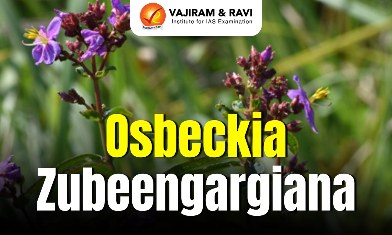
About Osbeckia zubeengargiana

  • It is a new plant species.
  • It was discovered in the grasslands of Manas National Park in Baksa District, Assam.
  • It has been named after celebrated Assamese singer Zubeen Garg, marking a rare tribute from the world of botany to a cultural icon of the region.
  • The plant belongs to the Melastomataceae family, a group known for its diverse flowering shrubs found across tropical and subtropical regions.
  • It is a perennial erect shrub that can grow up to 3.5 metres in height.
  • The plant is characterised by its delicate purple to pinkish four-petalled (tetramerous) flowers.
  • The shrub thrives in moist soil conditions and blooms seasonally, adding to the floral diversity of the grassland ecosystem.
  • The plant typically flowers and bears fruit between mid-September and January.

Source: IT

Osbeckia zubeengargiana FAQs

Q1: What is Osbeckia zubeengargiana?

Ans: It is a newly discovered plant species.

Q2: Where was Osbeckia zubeengargiana discovered?

Ans: It was discovered in the grasslands of Manas National Park in Baksa District.

Q3: After whom was Osbeckia zubeengargiana named?

Ans: It was named after Assamese singer Zubeen Garg.

Q4: What type of plant is Osbeckia zubeengargiana?

Ans: It is a perennial erect shrub.

Kharg Island

Kharg Island

Kharg Island Latest News

Kharg Island is in the news after the United States launched airstrikes on military targets there amid escalating tensions with Iran, raising concerns about disruptions to global oil supply.

About Kharg Island

  • It is a small coral island in Iran in the northern Persian Gulf.
  • It lies about 30 Km from the Iranian mainland.
  • Its area is 25 sq.km., its length is 8 km, and its width is 4.5 km.
  • This rocky limestone island is unique because it is one of the few islands in the Persian Gulf with freshwater, which has collected within the porous limestone.
  • The island experiences hot and humid summers, and its highest point, Mount Didehban, stands at 87 meters above sea level.
  • The discovery of an offshore oil field in the waters around Kharg in the early 1960s stimulated the development of the island as a site for major petroleum and petrochemical installations. 
  • Connection by pipelines to the underwater oil fields, as well as to the oil fields in Khuzistan province, transformed Kharg into Iran's largest oil-loading terminal by the early 1970s. 
  • During the Iran–Iraq war (1980–1988), Kharg repeatedly was bombed, and its oil facilities suffered extensive damage, but they were reconstructed in the early 1990s.
  • It facilitates as much as 90 percent of the country's oil exports and is vital for Iran's economy.
  • It boasts a massive storage capacity of 28 million barrels and loading infrastructure capable of handling VLCCs and ULCCs.
  • It has a loading capacity of about 7 million barrels per day. It can load eight to nine supertankers simultaneously.
  • Its strategic significance lies in its proximity to the Strait of Hormuz, a crucial global oil passage.

Source: TELE

Kharg Island FAQs

Q1: Where is Kharg Island located?

Ans: It is a small coral island in Iran in the northern Persian Gulf.

Q2: Why is Kharg Island unique among many Persian Gulf islands?

Ans: It is one of the few islands in the Persian Gulf with freshwater, which has collected within the porous limestone.

Q3: What is the importance of Kharg Island to Iran's economy?

Ans: It facilitates as much as 90 percent of the Iran's oil exports.

Q4: What is the oil storage capacity of Kharg Island?

Ans: Around 28 million barrels.

Myiophanes kempi

Myiophanes kempi

Myiophanes kempi Latest News

Recently, researchers rediscovered Myiophanes kempi in limestone caves in the Andaman Islands after almost 100 years gap.

About Myiophanes kempi

  • It is a slender-bodied assassin bug belonging to the subfamily of Reduviidae.
  • It was first described by British entomologist Willian Edward China in 1924.
  • It was previously described from Siju Cave in Meghalaya a century ago.

Characteristics of Myiophanes kempi

  • It is a specialised predator of the subterranean ecosystem and lives in its complete lifecycle in the darkness.
  • It uses the long raptorial forelegs for snatching prey -- small arthropods of the dark cave environment.

Key Facts about Siju Cave

  • Location: It is one of the longest limestone cave systems in the world situated in Garo Hills in the state of Meghalaya.
  • It is also known as Dobakkol or Bat Cave, is one of India's longest limestone caves, stretching over 4.7 km.
  • It is located near the Simsang River.
  • It is famous for its stunning rock formations and underground streams. 

Source: TH

Myiophanes kempi FAQs

Q1: Where was the Myiophanes kempi thread-legged assassin bug rediscovered?

Ans: Andaman limestone caves

Q2: What family does Myiophanes kempi belong to?

Ans: Reduviidae

Silverpit Crater

Silverpit Crater

Silverpit Crater Latest News

New research has confirmed that the Silverpit Crater was formed by a massive asteroid impact millions of years ago.

About Silverpit Crater

  • Location: It lies about 700 meters beneath the seabed in the North Sea, roughly 80 miles off the coast of Yorkshire, United Kingdom.
  • Silverpit is buried under a huge layer of sediment and was only discovered in 2002.
  • Formation: It was formed by a high-velocity space rock striking the seabed roughly 43 to 46 million years ago.
  • Scientific Evidence: Researchers identified “shocked" quartz and feldspar crystals in rock samples from a nearby oil well that only form under the extreme shock pressures of a high-velocity space impact.

Features of Silverpit Crater

  • It measures roughly three kilometres wide and is surrounded by a ring of circular faults stretching nearly 20 kilometres across.
  • It consists of a set of concentric faults up to 20 km in diameter in the southern North Sea. 
  • It is a rare and exceptionally well-preserved hypervelocity impact crater.
  • Its round shape and central peak resembled classic impact craters. 

Source: ET

Silverpit Crater FAQs

Q1: Where is the Silverpit Crater located?

Ans: North Sea

Q2: What is the Silverpit Crater believed to be?

Ans: An impact crater

Herpes Simplex Virus (HSV)

Herpes Simplex Virus (HSV)

Herpes Simplex Virus (HSV) Latest News

About 92 inmates of Jalpaiguri Central Correctional Home (JCCH) in West Bengal were infected with the Herpes Simplex Virus (HSV) between August 20, 2025, and March 9 this year, with seven of the infected inmates losing their lives.

About Herpes Simplex Virus (HSV)

  • Herpes simplex virus (HSV), known as herpes, is a common infection that can cause painful blisters or ulcers. 
  • There are two types of HSV:
    • HSV-1: This type primarily causes oral herpes, characterized by cold sores or fever blisters that appear around your mouth or on your face.
    • HSV-2: This primarily causes genital herpes, which involves sores that appear on or around your genitals, anus, buttocks, and inner thighs.

Herpes Simplex Virus (HSV) Transmission

  • HSV is highly contagious. It is spread by skin-to-skin contact with someone who carries the virus.
  • Once infected, a person will have the HSV for the rest of their life.
  • HSV can periodically reactivate, causing symptoms.

Herpes Simplex Virus (HSV) Symptoms

  • Most people with herpes have no symptoms or only mild symptoms.
  • Many people aren’t aware they have the infection and can pass along the virus to others without knowing.
  • Others might experience occasional episodes of small, fluid-filled blisters or sores. 
  • These sores and blisters are typically painful. Blisters may break open, ooze, and then crust over. 
  • New infections may cause fever, body aches, and swollen lymph nodes.
  • In rare cases, infection with HSV-1 or HSV-2 can lead to meningitis (inflammation of the covering of the brain and spinal cord) or encephalitis (inflammation of the brain).

Herpes Simplex Virus (HSV) Treatment 

  • It is treatable but not curable.
  • Antivirals and home remedies can help ease the severity of symptoms. Antiviral medication may also lead to fewer herpes episodes.

Source: TH

Herpes Simplex Virus (HSV) FAQs

Q1: What is Herpes simplex virus (HSV)?

Ans: It is a common viral infection that can cause painful blisters or ulcers on the skin.

Q2: How is the Herpes simplex virus transmitted?

Ans: It spreads through skin-to-skin contact with an infected person.

Q3: What are common symptoms of herpes infection?

Ans: Small, painful fluid-filled blisters or sores that may break open, ooze, and crust over.

Q4: Is herpes curable?

Ans: No, herpes is treatable but not curable.

Joha Rice

Joha Rice

Joha Rice Latest News

Recently, India has facilitated the export of 25 metric tonnes of Assam’s GI-tagged Joha Rice to the United Kingdom and Italy.

About Joha Rice

  • It is an indigenous rice of Assam.
  • It is an indigenous aromatic rice variety known for its distinct fragrance, fine grain texture and rich taste.
  • It is grown in the Sali/ Kharif season.
  • Major Joha varieties included in this are Kola Joha, Keteki Joha, Bokul Joha and Kunkuni Joha.
  • This rice is also rich in several antioxidants, flavonoids, and phenolics.
  • It has got a Geographical Indication (GI) tag in 2017.
  • This rice variety has two unsaturated fatty acids viz., linoleic acid (omega-6) and linolenic (omega-3) acid.
    • These essential fatty acids (which humans cannot produce) can help maintain various physiological conditions.

What is a Geographical Indication Tag?

  • It is a sign used on products that have a specific geographical origin and possess qualities or a reputation that are due to that origin.
  • This is typically used for agricultural products, foodstuffs, wine and spirit drinks, handicrafts and industrial products.
  • The Geographical Indications of Goods (Registration and Protection) Act, 1999 seeks to provide for the registration and better protection of geographical indications relating to goods in India.
  • This GI tag is valid for 10 years following which it can be renewed.

Source: News On Air

Joha Rice FAQs

Q1: Where is Joha Rice primarily grown?

Ans: Assam

Q2: What is special about Joha Rice?

Ans: It's got Geographical Indication (GI) tag

Tanzania

Tanzania

Tanzania Latest News

Recently, India has dispatched a consignment of essential life-saving medicines to Tanzania as humanitarian assistance.

About Tanzania

  • Location: It is an East African country situated just south of the Equator.
  • Bordering Countries: It shares borders with eight countries: Kenya and Uganda to the north, Rwanda, Burundi, and the Democratic Republic of the Congo to the west, and Zambia, Malawi, and Mozambique to the south. 
  • Maritime Border: The eastern border of Tanzania meets the Indian Ocean.
  • Capital: Dar es Salaam (administrative captial), Dodoma (legislative capital).

Geographical Features of Tanzania

  • Climate type: Tropical, with a long dry season and two rainy seasons.
  • Major lakes: Lake Victoria (the world’s second-largest freshwater lake, shared with Uganda and Kenya) in the north, Lake Tanganyika in the west, and Lake Nyasa in the southwest.
  • Highest Peak: Mount Kilimanjaro
  • Major rivers:  Great Ruaha, Rufiji, and Kagera rivers. 
  • Islands: It includes Zanzibar, Pemba, and Mafia, all located off the eastern coast in the Indian Ocean.

Source: News On Air

Tanzania FAQs

Q1: Tanzania is home to which famous national park?

Ans: Serengeti National Park

Q2: Which mountain in Tanzania is Africa's highest peak?

Ans: Mount Kilimanjaro

Deepor Beel

Deepor Beel

Deepor Beel Latest News

Illegal earth cutting from a wetland connected to Deepor Beel is continuing unabated in the Satmile area of Guwahati, despite prohibitory orders from the district administration and restrictions imposed by the Gauhati High Court.

About Deepor Beel

  • It is a permanent freshwater lake located on the outskirts of Guwahati, Assam. 
  • It lies in a former channel of the Brahmaputra River.
  • Beel is an Assamese local word which means ‘lake’, and the name Deepor Beel means the ‘lake of elephants’.
  • It covers an area of 4.1 sq.km. It is considered one of the biggest lakes of the Brahmaputra Valley of Lower Assam.
  • It is surrounded by steep highlands on the northern and southern sides, and its main sources of water are the Kalmani and Basistha Rivers.
  • It is the only major stormwater storage basin for the city of Guwahati. 
  • The lake’s outflow is the Khandajan rivulet, which joins the Brahmaputra.
  • It was recognised as a Ramsar Site in 2002 and as an Important Bird and Biodiversity Area (IBA) in 2004. It is the only Ramsar site in the state of Assam.
  • This lake is a staging site on migratory flyways, and some of the largest concentrations of aquatic birds in Assam can be seen, especially in winter. 
  • Some globally threatened birds are supported, including Spot-billed Pelican, Lesser Greater Adjutant Stork, and Baer’s Pochard.
  • About 50 fish species and aquatic resources provide livelihood support to about 1,200 households residing in about 12 villages on the fringes of the wetland.
  • The Rani and Garbhanga hills, the habitat of the Asiatic elephants on the southern side of the beel, are part of this ecosystem.

Source: SENT

Deepor Beel FAQs

Q1: Where is Deepor Beel located?

Ans: It is a permanent freshwater lake located on the outskirts of Guwahati in Assam.

Q2: Deepor Beel lies in a former channel of which river?

Ans: The Brahmaputra River.

Q3: What is the outflow channel of Deepor Beel?

Ans: The Khandajan rivulet, which later joins the Brahmaputra River.

Q4: What is the significance of Deepor Beel in Assam’s wetland network?

Ans: It is the only Ramsar site in Assam.

Deendayal Port

Deendayal Port

Deendayal Port Latest News

The Deendayal Port in Gujarat's Kandla is gearing up to handle a whopping 22 vessels over a 72-hour period over the weekend.

About Deendayal Port

  • Deendayal Port (previously called Kandla Port) is the second largest seaport of India, situated in the Kachchh District of Gujarat State in western India.  
  • It is situated in the creek of Kandla, which is at a distance of 90 kms from the Gulf of Kachchh.  
  • It is a protected natural harbor.
  • It is recognized as one of the major ports in India.
  • It was constructed in the 1950s as the chief seaport serving western India after the partition of India from Pakistan left the port of Karachi in Pakistan. 
  • It is 256 nautical miles southeast of the Port of Karachi in Pakistan and over 430 nautical miles north-northwest of the Port of Mumbai.
  • The port is specialized in handling bulk import and export cargo, including liquid cargo.
  • It features 18 berths, including 12 dry cargo berths and 6 oil jetties, handling a wide range of cargo such as petroleum, chemicals, iron ore, salt, and containers.
  • It remains India’s biggest state-owned cargo handler by volume, but it has steadily lost market share to privately owned Mundra Port (India’s largest private port), 60 km to the southwest.

Source: WEEK

Deendayal Port FAQs

Q1: What was the former name of Deendayal Port?

Ans: Kandla Port.

Q2: Where is Deendayal Port located?

Ans: It is located in Kachchh District in Gujarat.

Q3: In which creek is Deendayal Port situated?

Ans: It is situated in the Kandla Creek.

Q4: Why was Deendayal Port constructed in the 1950s?

Ans: It was built to serve as the chief seaport of western India after the Partition of India, when Port of Karachi became part of Pakistan.

Musi River

Musi River

Musi River Latest News

Several historic landmarks have been identified as part of the 55-km Musi river rejuvenation project, with authorities exploring ways to link them through heritage tourism and cultural initiatives along the river corridor.

About Musi River

  • The Musi River, also known as the Muchukunda or Musunuru River, is a major tributary of the Krishna River in the Deccan Plateau, flowing through Telangana.
  • The river gained prominence in the late 16th century when Muhammad Quli Qutb Shah, the founder of Hyderabad, established the city along its banks.
  • Course:
    • It originates from Anantagiri Hills near Vikarabad District.
    • The river is formed by the merging of two small rivulets: Esi (8 km) and Musa (13 km).
    • After originating, the Musi River flows in an eastward direction, cutting through the heart of Hyderabad city, where it historically divided the Old City from the New City.
    • The river then continues its journey through the southern Telangana plains.
    • It ultimately joins the Krishna River near Wazirabad in Nalgonda district.
  • Total Length: 240 kilometers.
  • Dams: Himayat Sagar and Osman Sagar are the two dams that are constructed over the river.
  • Hussain Sagar Lake was built on a tributary of the River Musi. It was a lake of 24 kilometres, built to meet the water and irrigation needs of the city.
  • Several historic bridges and mosques line its banks, reflecting Qutb Shahi and Nizam-era architecture.
  • The Musi River has 24 diversion weirs for irrigation, locally known as kathwas.
  • Now due to random urbanization and lack of planning the river has become a holder of all the unprocessed domestic and industrial waste drained out of Hyderabad.

Source: DC

Musi River FAQs

Q1: The Musi River is a major tributary of which river?

Ans: Krishna

Q2: What is the origin of the Musi River?

Ans: Anantagiri Hills, Vikarabad, Telangana

Q3: Which city does the Musi River flow through?

Ans: Hyderabad

Q4: What is the approximate length of the Musi River?

Ans: 240 km

Alprazolam

Alprazolam

Alprazolam Latest News

Recently, the Directorate of Revenue Intelligence (DRI) has busted a clandestine facility engaged in the production of Alprazolam in Andhra Pradesh.

About Alprazolam

  • It is a psychotropic substance under the Narcotics, Drugs and Psychotropic Substances (NDPS) Act 1985.
  • This drug falls under the benzodiazepines class of drugs, and is a tranquillizing agent used in the treatment of anxiety disorders.
    • Benzodiazepines belong to the group of medicines called central nervous system (CNS) depressants, which are medicines that slow down the nervous system.
  • Alprazolam enhances the activity of a neurotransmitter in the brain called gamma-aminobutyric acid (GABA). 
  • Used for: It is used to treat anxiety disorders, panic disorders, and anxiety caused by depression.

Key Facts about Directorate of Revenue Intelligence

  • It was constituted in 1957 as the apex anti-smuggling intelligence and investigation agency.
  • Functions: It is tasked with detecting and curbing smuggling of contraband, including drug trafficking and illicit international trade in wildlife and environmentally sensitive items, as well as combating commercial frauds related to international trade and evasion of customs duty.
  • Nodal Ministry: It works under the Central Board of Indirect Taxes & Customs (CBIC), Ministry of Finance, Government of India. 

Source: TH

Alprazolam FAQs

Q1: Which class of medications does Alprazolam belong to?

Ans: Benzodiazepines

Q2: What is Alprazolam used for?

Ans: Anxiety and panic disorders

Enquire Now