El Ashmunein

Key Facts about El Ashmunein

El Ashmunein Latest News

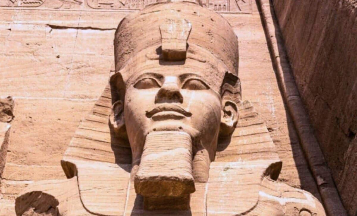
Archaeologists working in El Ashmunein recently uncovered a massive limestone fragment that completes a royal statue first discovered nearly a century ago, revealing new details about Ramesses II, the pharaoh who ruled Egypt from 1279 to 1213 BCE.

About El Ashmunein

  • Hermopolis Magna, present-day el-Ashmunein, is an ancient town of Upper Egypt, located on the west bank of the Nile River.
  • It has religious, cultural, and administrative importance from the Old Kingdom to the Greco-Roman era.
  • The city was devoted to Thoth, the ibis-headed god associated with wisdom and writing.
  • The ancient Egyptian name for the town was Khmun ('City of the Eight'), a reference to the Ogdoad of Hermopolis, a collective of eight "primordial" deities whose worship was centered there.
  • It used to be distinguished as the capital of the Hare nome, the fifteenth nome of Upper Egypt.
  • The city featured monumental structures like the Temple of Thoth, decorated with statues, inscriptions, and stelae. 
  • In the Christian era, it became an early Coptic center, marked by a 5th-century basilica. 
  • Archaeological excavations have unearthed mudbrick houses, cemeteries, altars, and reused royal cartouches from rulers like Akhenaten and Nectanebo II, illustrating the city's rich multi-era legacy.
  • Nearby there are also extensive underground galleries, constructed mainly between the Late Period and Roman times.

Source: IDR

El Ashmunein FAQs

Q1: What is El Ashmunein historically known as?

Ans: It was known as Hermopolis Magna.

Q2: Where is El Ashmunein located?

Ans: It is located in Upper Egypt on the west bank of the Nile River.

Q3: Which Egyptian deity was primarily worshipped at El Ashmunein?

Ans: The city was devoted to Thoth, the ibis-headed god associated with wisdom and writing.

Q4: What was the ancient Egyptian name of El Ashmunein?

Ans: Khmun.

Q5: Which major temple was located in the city of El Ashmunein?

Ans: The Temple of Thoth.

Iraq

Key Facts about Iraq

Iraq Latest News

Recently, six crew members aboard a US KC-135 refuelling aircraft that crashed in western Iraq have been confirmed dead.

About Iraq

  • Location: It is a Western Asian country.
  • Bordering Countries: It is bordered by six nations: Iran to the East; Kuwait to the southeast; Turkey to the north; Syria to the west; Jordan to the southwest and Saudi Arabia to the south.
  • Maritime Border: The country has a coastline along the northern end of the Persian Gulf.
  • Capital City: Baghdad

Geographical Features of Iraq

  • Climate: The climate in Iraq is mainly of the continental, subtropical semi-arid type, with the north and north-eastern mountainous regions having a Mediterranean climate.
  • Major Mountains: Its most prominent hill range is the Sinjār Mountains, whose highest peak reaches an elevation of 4,448 feet (1,356 metres).
  • Major Rivers: Two of the most significant rivers in all of Asia, the Euphrates and Tigris Rivers, drain the land.
  • Lakes:  Habbaniya and Razzaza 
  • Desert: Western and southern Iraq is a vast desert region. 
  • Natural resources:  It mainly consists of Oil, natural gas, phosphates, and sulfur.

Source: TOI

Iraq FAQs

Q1: What is the capital of Iraq?

Ans: Baghdad

Q2: Which rivers flows through Iraq?

Ans: Tigris and Euphrates

Acrylonitrile

Acrylonitrile

Acrylonitrile Latest News

Recent computer models have suggested that acrylonitrile, an organic compound present on Saturn’s moon Titan, can self-assemble into cell-like structures.

About Acrylonitrile

  • It is an organic compound produced by catalytic reaction of propylene with ammonia. 
  • Properties
    • It is a colorless, liquid, man-made chemical with a sharp, onion- or garlic-like odor.
    • It can be dissolved in water and evaporates quickly.
    • Acrylonitrile vapor is heavier than air.
    • It is very volatile, producing flammable and toxic air concentrations at room temperature and may explode.
    • Its combustion produces toxic oxides of nitrogen.
    • It requires storage and handling in closed systems.
  • Applications 
    • Acrylonitrile is used to make other chemicals such as plastics, synthetic rubber, and acrylic fibers.
    • A mixture of acrylonitrile and carbon tetrachloride was used as a pesticide in the past.
  • Impact on Human Health
    • Acrylonitrile is irritating to the skin, eyes, and respiratory tract.
    • Toxic effects range from headache, fatigue, dyspnea, nausea and vomiting to asphyxiation, lactic acidosis and cardiovascular collapse.

Source: TH

Acrylonitrile FAQs

Q1: What is Acrylonitrile primarily used for?

Ans: Production of acrylic fibers and resins

Q2: Acrylonitrile is a monomer for which polymers?

Ans: Polyacrylonitrile

Amblyceps vayavy

Amblyceps vayavy

Amblyceps vayavy Latest News

Researchers recently discovered a rare new catfish species, Amblyceps vayavy, in hill streams of the Western Ghats spanning Goa and Maharashtra.

About Amblyceps vayavy

  • It is a new species of catfish.
  • It was discovered in the biodiverse northern Western Ghats spanning the states of Goa and Maharashtra.
  • The fish inhabits shallow hill streams where the streambed is made up of sand, pebbles, and stones, creating microhabitats that help it hide and forage for food.
  • The name ‘vayavy’ means 'northwest' in Marathi and Konkani, referring to the species' habitat in the northwestern part of the Western Ghats. 
  • It is the northernmost confirmed record of the genus in the Western Ghats so far.
  • The species can be distinguished by features such as a bifurcated caudal fin, an incomplete lateral line, an absence of centrally projecting hooks in the veins in the middle of the tail, and a distinct adipose fin structure.
  • The species has so far been recorded only from a few scattered locations in Goa and Maharashtra, underscoring its rarity and the ecological importance of the fragile habitats it occupies.

Source: MD

Amblyceps vayavy FAQs

Q1: What is Amblyceps vayavy?

Ans: It is a newly discovered species of catfish.

Q2: Where was Amblyceps vayavy discovered?

Ans: It was discovered in the northern Western Ghats spanning Goa and Maharashtra.

Q3: In what type of habitat does Amblyceps vayavy live?

Ans: It inhabits shallow hill streams with sand, pebbles, and stones on the streambed.

Gajapati Empire

Key Fact about Gajapathi Empire

Gajapati Empire Latest News

A Telugu medieval inscription associated with the Gajapathi rulers of Odisha has been recently discovered on a stone pillar of the historic Lakshmi Narasimha Swamy Temple at Ramachandrapura Agraharam in Guntur city.

About Gajapati Empire

  • It was a medieval Hindu dynasty in the Indian subcontinent, originally from the region of Odisha, that reigned from c. 1434 to 1541. 
  • It succeeded the Eastern Gangas as the Gajapati monarchs and was founded by Kapilendra Deva of the Suryavamsa lineage after the death of the last ruler of the Eastern Ganga, king Bhanu Deva IV. 
  • Initially, the capital of the Gajapati Empire was located in Cuttack. However, during the reign of Prataparudra Deva (1497 to 1540), the capital was shifted to Kataka, now known as Konark.
  • The Gajapatis, at the height of their power in the 15th century, ruled over an empire extending from the Ganges in the north near Hoogly to the Kaveri in the south.
  • Gajapatis were great patrons of art, architecture, and literature.
    • The empire's architectural prowess is exemplified by the iconic Sun Temple at Konark, a UNESCO World Heritage Site.
    • Gajapatis' patronage of the Odia language, literature, and performing arts contributed to the cultural renaissance of Odisha.
  • Decline:
    • They ruled over a vast stretch of land and had continuous rivalry with the Vijayanagara empire. 
    • By the early 16th century, the Gajapatis lost great portions of their southern dominion to the Vijayanagara Empire and the Golconda Sultanate.
    • The empire's decline, marked by internal conflicts and invasions by regional powers, eventually led to the fall of the Gajapati dynasty, and the region later came under the control of the Mughal Empire in the late 16th century.

Source: DC

Gajapati Empire FAQs

Q1: What was the Gajapati Empire?

Ans: It was a medieval Hindu empire that originated in Odisha and ruled from around 1434 to 1541 CE.

Q2: Which dynasty did the Gajapati Empire succeed?

Ans: It succeeded the Eastern Ganga dynasty.

Q3: Who founded the Gajapati Empire?

Ans: The empire was founded by Kapilendra Deva.

Q4: Which famous temple reflects the architectural achievements associated with the Gajapati period?

Ans: The Konark Sun Temple.

Valles Marineris

Valles Marineris

Valles Marineris Latest News

By combining laboratory experiments with orbital data, researchers recently identified an unusual iron sulfate—ferric hydroxysulfate—forming in layered deposits near the massive Valles Marineris canyon system.

About Valles Marineris

  • Valles Marineris, or Mariner Valley, is a vast system of interconnected canyons on the planet Mars.
  • The system was discovered during, and named for, the Mariner 9 mission in 1971.
  • The canyons extend in an east-west direction for roughly 4,000 km just south of the equator
    • By comparison, Earth's natural wonder, the Grand Canyon, is only 446 km long.
  • It is one of the larger canyons in the solar system.
  • It spans about 20 percent of the entire circumference of Mars. 
  • Individual canyons are typically 200 km across and have walls 2–5 km high.
  • At the centre of the system, several canyons merge to form a depression 600 km across and 9 km deep.
  • The canyon system contains a number of different features that give clues to its formation. 
    • Some of the canyon walls appear to be fault scarps that formed as a result of crustal movement along faults radiating from the Tharsis rise, an enormous volcanic bulge to the northwest. 
    • Erosion, however, has also played a significant role in canyon formation, as indicated by deep gullies cut in the walls.
    • In places, the canyons contain thick sedimentary sequences that may have been deposited in lakes that formerly occupied the canyons. 
    • These lakes later may have drained catastrophically to the east, where there is evidence of large floods.

Source: SD

Valles Marineris FAQs

Q1: What is Valles Marineris?

Ans: It is a vast system of interconnected canyons on the planet Mars.

Q2: Approximately how long is Valles Marineris?

Ans: It is roughly 4,000 kilometres long.

Q3: During which mission was Valles Marineris discovered?

Ans: It was discovered during the Mariner 9 mission.

Q4: Which volcanic region on Mars is associated with the formation of Valles Marineris?

Ans: The Tharsis Rise.

Sujal Gaon ID

Sujal Gaon ID

Sujal Gaon ID Latest News

Recently, the Union Minister of Jal Shakti released the Sujal Gaon ID.

About Sujal Gaon ID

  • It is a scheme‑based unique digital identifier that enables complete digital mapping of rural piped water supply assets.
  • The Sujal Gaon IDs across 31 States/ UTs have been created, linked to 67,000 Sujalam Bharat IDs. 
  • Each Sujalam Bharat ID integrates the scheme’s infrastructure ID and service area ID, creating a comprehensive digital footprint of rural water service delivery. 
  • It is linked with the “Sujalam Bharat” national digital architecture which will provide source to tap mapping of the entire rural water supply chain through unique Sujal Gaon IDs/ Service Area ID for every village.
  • It was launched by the Ministry of Jal Shakti under the Jal Jeevan Mission.

Key Facts about Jal Jeevan Mission

  • It was launched on August 15, 2019.
  • JJM is envisioned to provide safe and adequate drinking water through individual Functional Household Tap Connections (FHTCs) by 2024 to all households in rural India. 
  • It is based on a community approach to water and will include extensive Information, Education and communication as key components of the mission.
  • Nodal Ministry: Ministry of Jal Shakti.
  • Funding Pattern for Jal Jeevan Mission
    • 50:50 between Centre and States
    • 90:10 for Himalayan and North-Eastern States
    • In case of UTs, 100% of the funding is provided by the Central government.

Source: PIB

Sujal Gaon ID FAQs

Q1: How will Sujal Gaon ID be used in Jal Jeevan Mission?

Ans: To assign unique IDs to rural piped water supply schemes

Q2: What is Sujal Gaon ID?

Ans: A digital ID for villages under Jal Jeevan Mission

National Chambal Sanctuary

National Chambal Sanctuary

National Chambal Sanctuary Latest News

Recently, the Supreme Court took suo motu cognisance of media reports about the constant threat caused by sand mining to the ecology and aquatic life of the eco-sensitive zone of the National Chambal Sanctuary.

About National Chambal Sanctuary

  • Location: It lies at the tri-junction of three states Madhya Pradesh, Uttar Pradesh and Rajasthan.
  • It is also called the National Chambal Gharial Wildlife Sanctuary.
  • It is a tri-state protected riverine sanctuary along 425 km length of the Chambal River and ravines.
  • The main focus of the sanctuary is to protect the critically endangered Gharial, Red-crowned roof turtle & endangered Ganges dolphin.
  • It supports the largest population of Gharials in the wild.
  • It is listed as an important bird area (IBA).
  • Topography: The topography is full of ravines, hills & sandy beaches.
  • Vegetation: It is part of the Kathiar-Gir dry deciduous forest ecoregion.
  • Fauna: It is home to mugger crocodile, smooth-coated otters, Striped Hyena & Indian wolves are also found here.
    • It also supports Indian narrow-headed soft shell turtles, three- striped roof turtles & crowned river turtles. 

Source: TH

National Chambal Sanctuary FAQs

Q1: What is the National Chambal Sanctuary primarily known for?

Ans: Ghariyal conservation

Q2: Which river flows through the National Chambal Sanctuary?

Ans: Chambal

Samriddh Gram Phygital Services Pilot Project

Samriddh Gram Phygital Services Pilot Project

Samriddh Gram Phygital Services Pilot Project Latest News

Recently, the Union Minister of Communications inaugurated the Samriddhi Kendra at Umri village in Guna district, Madhya Pradesh  under the Samriddh Gram Phygital Services Pilot Initiative.

About Samriddh Gram Phygital Services Pilot Project

  • It is envisaged as a pioneering phygital (physical + digital) Services model integrating on-ground presence with robust digital infrastructure to empower rural citizens.
  • It is aimed at transforming rural India through a seamless integration of physical and digital services.
  • It leverages BharatNet connectivity to deliver essential services seamlessly and sustainably.

Features of Samriddh Gram Phygital Services Pilot Project

  • Under this initiative three villages have been identified namely, Ari & Umri in Madhya Pradesh, Narakoduru in Andhra Pradesh, and Chaurawala in Uttar Pradesh.
  • Each village will host a Samriddhi Kendra which will serve as an integrated digital service hub.
  • The Samriddhi Kendras will deliver a comprehensive suite of services
    • Education & Skilling: Smart classrooms, AR/VR-based learning, and digital skilling aligned with government schemes/initiatives.
    • Agriculture: IoT-based soil testing, drone support, and smart irrigation systems.
    • Healthcare:  Teleconsultations, Health ATMs, and emergency care.
    • e-Governance: Assisted access to citizen services, documentation, and grievance redressal.
    • E-Commerce: Integration with ONDC and digital marketplaces for local entrepreneurship.
    • Financial Inclusion: Digital banking and payments
    • Connectivity Backbone: Strengthened BharatNet FTTH with a Village Area Network and public Wi-Fi hotspots.
  • Implemented by: The Department of Telecommunications (DoT)

Source: PIB

Samriddh Gram Phygital Services Pilot Project FAQs

Q1: What is the primary objective of the Samriddh Gram Phygital Services Pilot Initiative?

Ans: To integrate physical and digital services in rural areas

Q2: How many villages are part of the Samriddh Gram Phygital Services Pilot Initiative?

Ans: 3

Two New Moth Species

Two New Moth Species

Two New Moth Species Latest News

Scientists have discovered two brand-new species of moths named Eudemopsis hunliensis and Eudemopsis gobuka in the lush, remote forests of Northeast India.

About Eudemopsis hunliensis and Eudemopsis gobuka

  • They are two new species of moths.
  • They were discovered in the remote forests of the Upper Siang and Lower Dibang Valley districts of Arunachal Pradesh.
  • The findings expand the known range of the genus Eudemopsis, a group of micromoths previously thought to live only in East Asian countries such as China, Japan, and Vietnam.
  • E. hunliensis is distinguished by its distinct brownish-purple scales on its head and a unique pitcher-shaped structure in the male anatomy. 
  • E. gobuka features dark grey hindwings and a distinctive subrectangular patch on its forewings, which separates it from its closest relatives in Vietnam.
  • The names of the new moths pay direct tribute to the land where they were first found. 
    • The name hunliensis is derived from the town of Hunli in the Lower Dibang Valley. 
    • Similarly, gobuka is named after the village of Gobuk in the Upper Siang district.

Source: RM

Two New Moth Species FAQs

Q1: What are Eudemopsis hunliensis and Eudemopsis gobuka?

Ans: They are two newly discovered species of moths.

Q2: In which Indian state were Eudemopsis hunliensis and Eudemopsis gobuka discovered?

Ans: They were discovered in Arunachal Pradesh.

Q3: What distinctive feature characterizes Eudemopsis hunliensis?

Ans: It has brownish-purple scales on its head and a unique pitcher-shaped structure in the male anatomy.

Q4: What distinguishing feature is seen in Eudemopsis gobuka?

Ans: It has dark grey hindwings and a distinctive subrectangular patch on its forewings.

Enquire Now