Digital Connectivity Rating Platform

Digital Connectivity Rating Platform

Digital Connectivity Rating Platform Latest News

Recently, the Telecom Regulatory Authority of India (TRAI) launched the Digital Connectivity Rating (DCR) Platform. 

About Digital Connectivity Rating Platform

  • It is an integrated digital platform designed for rating of digital connectivity of properties across residential, commercial, and government properties.
  • It was launched by the Telecom Regulatory Authority of India.
  • Objective: To encourage property managers to build digitally connected and future ready smart properties and assess whether properties are equipped with robust digital infrastructure, enhancing user experience for tenants, residents, and businesses.
  • The platform provides a public interface for consumers to view the properties rated for digital connectivity.

Features of Digital Connectivity Rating Platform

  • It brings Property Managers (PMs) registered Digital Connectivity Rating Agency (DCRA) and consumers onto a common digital interface.
  • Property Managers
    • They can register their properties in category of Public, Government, Commercial, Private etc., submit rating applications, upload the prescribed information and documents, select a registered DCRA and track the status of their application through the platform.
    • The platform supports both constructed and under-construction properties.  
  • Registered DCRAs
    • They can access assigned applications, undertake assessments, record observations and test results, manage supporting documentation and complete the rating process in accordance with the prescribed framework.
    • Field assessments will be facilitated through a dedicated DCRA mobile app.
  • Consumers
    • They can search for a rated property by property name, certificate ID or location.
    • They can view the property’s digitally signed rating certificate and verify its authenticity through the QR code provided on the certificate.

Source: PIB

Digital Connectivity Rating Platform FAQs

Q1: What is Digital Connectivity Rating Platform?

Ans: It is an integrated digital platform designed for rating of digital connectivity of properties across residential, commercial, and government properties.

Q2: Which organisation launched the Digital Connectivity Rating Platform?

Ans: It was launched by the Telecom Regulatory Authority of India.

Ehlers-Danlos Syndrome

Ehlers-Danlos Syndrome

Ehlers-Danlos Syndrome Latest News

Recent researches across the world provided new insights about causes of Ehlers-Danlos Syndrome and its association with hormone levels and sleep apnea. 

About Ehlers-Danlos Syndrome

  • It is a group of conditions that affect the connective tissue of the human body, typically loosening or weakening it.
  • Connective tissue supports and provides flexibility to the skin, tendons, ligaments, bones, blood vessels, and organs.
  • EDS is generally inherited and is commonly associated with hypermobility, meaning one’s joints can move past their normal range of motion.
  • Cause: EDS is caused by certain genetic changes and is generally passed down to children by their parents.
  • Treatment: There is no cure for EDS, but symptoms, especially those of hEDS, can be managed.

Types of Ehlers-Danlos Syndrome

  • Hypermobile EDS (hEDS)
    • It is the most common form of EDS.
    • It shows symptoms such as stretchy, fragile skin, loose and clicky joints that dislocate easily, joint pain, and joint hypermobility.
    • hEDS may also manifest as extreme fatigue, skin that bruises quickly, digestive issues, and poor bladder control etc.
  • Classical EDS
    • It is a less common type of EDS, also exhibits similar symptoms, but it mostly affects the skin.
    • A person with this condition might have very stretchy and fragile skin that bruises easily or splits easily, especially around the elbows, on the forehead, and on the knees.
  • Vascular EDS
    • It affects one’s internal organs.
    • This results in fragile blood vessels that can tear easily and cause internal bleeding, which can be life-threatening.
    • This condition poses a serious risk of bowel tearing, womb tearing during pregnancy, and lung collapse, among others.
  • Kyphoscoliotic EDS (kEDS)
    • It affects the curvature of the spine. It might manifest during early childhood and is also characterised by joint hypermobility and loose joints.

Source: TH

Ehlers-Danlos Syndrome FAQs

Q1: What is Ehlers-Danlos Syndrome?

Ans: It is a group of conditions that affect the connective tissue of the human body, typically loosening or weakening it.

Q2: What is cause for Ehlers-Danlos Syndrome?

Ans: It is caused by certain genetic changes and is generally passed down to children by their parents.

Mission Pegase 26

Mission Pegase 26

Mission Pegase 26 Latest News

As part of Mission Pégase 26, the French Air and Space Force recently deployed four Rafale F4 fighters, three A330 MRTT Phénix multi-role tanker transport aircraft, and two A400M Atlas aircraft to Jodhpur.

About Mission Pegase 26

  • It is the seventh edition of France's long-range air projection exercise. 
  • It is being conducted from September 8 to October 15. 
  • Distance: More than 40,000 kilometres 
  • Force: Around 300 personnel, four Rafale F4 fighters, three A330 MRTT Phénix multi-role tanker transport aircraft, two A400M Atlas aircraft. 
  • Route: 
    • Greenland, Canada, Alaska, Japan, South Korea, Indonesia, India, Qatar, Réunion, and then Egypt.
    • Pegase 26 is following a route linking the Arctic, Indo-Pacific, and Middle East.  
  • Stated aims: Operational readiness, strategic partnerships, freedom of air navigation. 
  • India is a key stop on the Indo-Pacific leg of Pegase 26. 
  • In India, the French contingent will participate in Tarang Shakti.

Exercise Tarang Shakti 2026

  • It is the multinational air combat exercise hosted by the Indian Air Force (IAF).
  • Venue: Air Force Station, Jodhpur, and adjoining air bases.  
  • It is the second edition of the exercise. The maiden edition of the exercise took place in August-September 2024 in two phases.
  • Participating Countries: Seven foreign air forces—from the U.S., France, Germany, Australia, Bangladesh, Sri Lanka and the UAE—are participating,  while 32 nations will be attending as observers.
  • It is aimed at enhancing interoperability among participating air forces, while providing a platform for exchanging operational experience and showcasing India’s air combat capabilities.
  • The exercise will see the participation of advanced combat aircraft, including the U.S. Air Force’s F-35, the French Rafale, the UAE’s F-16, and a Bangladeshi C-130J.
  • The IAF will field a range of its frontline platforms, including the Rafale, Mirage-2000, Jaguar, Tejas, MiG-29, and Su-30MKI.

News: TH

Mission Pegase 26 FAQs

Q1: What is Mission Pegase 26?

Ans: It is France's long-range air projection exercise.

Q2: What is the approximate distance covered during Mission Pegase 26?

Ans: More than 40,000 kilometres.

Q3: Which regions are connected by the route of Mission Pegase 26?

Ans: The Arctic, Indo-Pacific and Middle East.

Q4: In which Indian exercise will the French contingent participate during Mission Pegase 26?

Ans: Tarang Shakti.

Caspian Cobra

Caspian Cobra

Caspian Cobra Latest News

Researchers have documented the first confirmed snakebite envenomation and subsequent human deaths in India caused by the venomous Caspian cobra (Naja oxiana).

About Caspian Cobra

  • It is the most venomous cobra in the world. 
  • It is a species of venomous snake in the family Elapidae.  
  • Other names: It is also called the Central Asian cobra, ladle snake, Oxus cobra, or Russian cobra.
  • Habitat: It thrives in arid and semi-arid regions, including rocky hillsides and scrublands. 
  • Distribution: It is native to Central Asia.
    • It is found in parts of Turkmenistan, Uzbekistan, Kyrgyzstan, Tajikistan, the Fergana Valley, north and east Afghanistan, northeastern Iran, the northern half of Pakistan from the Kashmir region east to the state of Himachal Pradesh in India, and in southwestern Tajikistan.
  • Features
    • It is slightly shorter than the Indian cobra.
    • Its body is slender, uniformly thick from head to midbody, and ends with a medium-length tail. 
    • It has long cervical ribs capable of expansion to form a hood. It has no hood marking, just a plain colour instead.  
    • When threatened, it will spread its hood to appear larger and more intimidating. 
    • Its coloration can vary from light brown to dark brown or even black, sometimes with a faint banding pattern. 
  • Behavior: These snakes are good climbers and able swimmers.
  • Diet: These are carnivores and prey on small mammals, amphibians, and birds.
  • Hibernation: They hibernate from late September or late October to late March-April.
  • Conservation Status
    • IUCN Red List: Near Threatened

Source: TH

Caspian Cobra FAQs

Q1: Where do we find Caspian Cobra?

Ans: It thrives in arid and semi-arid regions, including rocky hillsides and scrublands. 

Q2: What is the scientific name of Caspian Cobra?

Ans: Naja oxiana

ICGS Shaunak

ICGS Shaunak

ICGS Shaunak Latest News

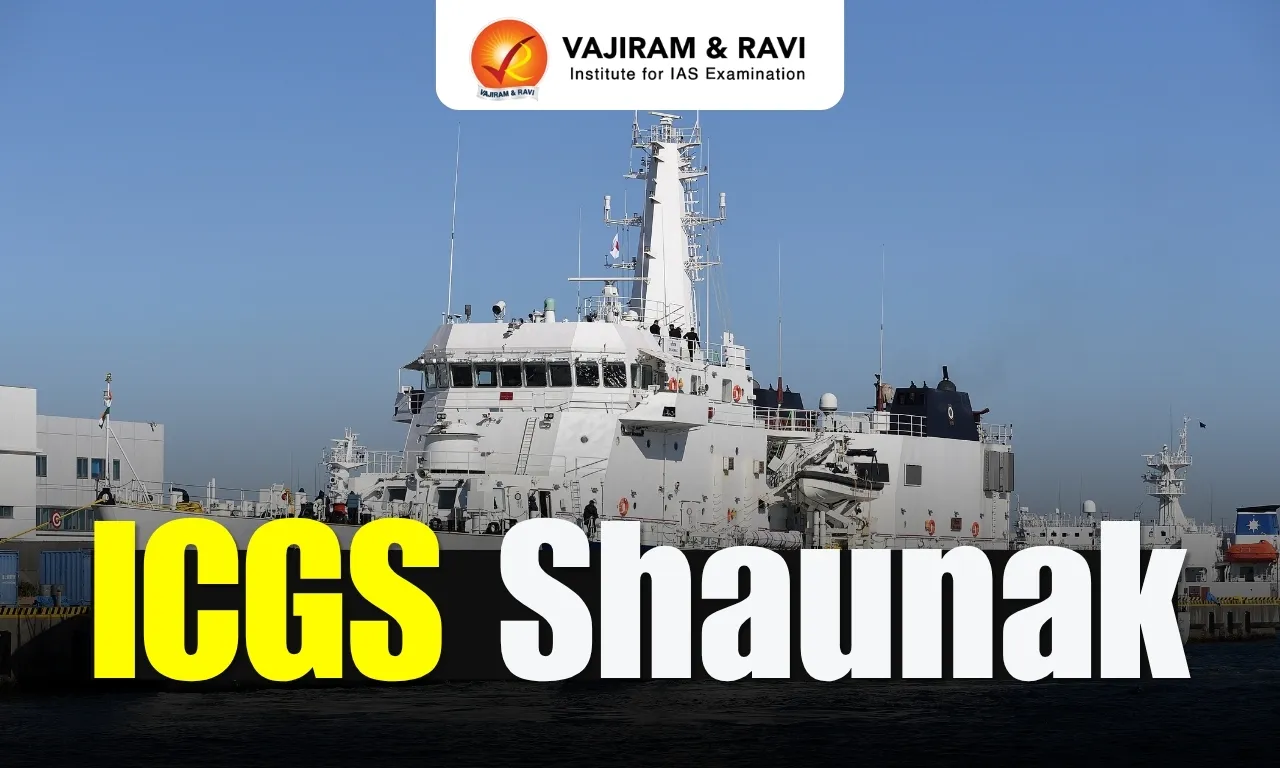
Indian Coast Guard (ICG) ship Shaunak recently sailed from Chennai for Perth, Australia, as part of the QUAD-at-Sea Ship Observer Mission, aimed at enhancing maritime interoperability among India, Australia, Japan, and the United States.

About ICGS Shaunak

  • It is an Indian Coast Guard ship, specifically an Offshore Patrol Vessel (OPV) of the Samarth-class. 
  • It has been designed and built indigenously by Goa Shipyard Ltd.
  • ICGS Shaunak was commissioned on February 21, 2017. 
  • It is based at Visakhapatnam under the administrative and operational control of the Commander, Coast Guard Region (East).  
  • It is deployed extensively for EEZ surveillance and other duties to safeguard the maritime interests of India. 

ICGS Shaunak Features

  • With a length of 105 m, the ship draws 2500 tons (GRT) propelled by two 9100 KW diesel engines.
  • It has a maximum speed of 26 knots and has an endurance of 6500 NM at economical speed.  
  • Its features include a 30 mm CRN 91 Naval Gun, Integrated Bridge System (IBS), Integrated Machinery Control System (IMCS), Power Management System (PMS), and High Power External Fire Fighting System. 
  • The ship is designed to carry one twin-engine Light Helicopter and five high-speed boats, including two Quick Reaction Inflatable Boats for swift boarding operations, search and rescue, law enforcement, and maritime patrol. 
  • The ship is also capable of carrying pollution response equipment to contain oil spills at sea. 

QUAD-at-Sea Ship Observer Mission

  • It brings together personnel from the four QUAD countries (India, United States, Japan, and Australia) for shipboard activities and professional exchanges.
  • It is aimed at enhancing interoperability, improving coordination, and strengthening mutual trust among the maritime forces.   
  • Six officers, described as Sea Riders, have embarked on ICGS Shaunak for the mission to sail from Chennai for Perth, Australia. 
  • The contingent comprises two officers each from India and Japan and one officer each from Australia and the United States. 
  • The mission also reflects India’s broader maritime vision of MAHASAGAR (Mutual and Holistic Advancement for Security and Growth Across Regions).

News: TH

ICGS Shaunak FAQs

Q1: What is ICGS Shaunak?

Ans: It is an Indian Coast Guard Offshore Patrol Vessel (OPV) of the Samarth class.

Q2: Where was ICGS Shaunak designed and built?

Ans: It was indigenously designed and built by Goa Shipyard Limited.

Q3: When was ICGS Shaunak commissioned?

Ans: 21 February 2017.

Q4: What is the endurance of ICGS Shaunak at economical speed?

Ans: Approximately 6,500 nautical miles.

Global Cities Index 2026

Global Cities Index 2026

Global Cities Index 2026 Latest News

Delhi has secured the 268th position among 1,000 cities in the Oxford Economics Global Cities Index 2026. 

About Global Cities Index (GCI)

  • It is an annual report published by Oxford Economics, a leading global economic advisory firm.  
  • The index ranks 1000 cities across the world based on five major factors: Economics, Human Capital, Quality of Life, Environment and Governance. 
  • The rankings are designed to look at both a city's present performance and its future potential. 
  • GCI 2026 Highlights:
    • New York has taken the top spot in the index. 
    • London has been ranked second, followed by Paris at third, Seattle at fourth, and San Francisco at fifth. 
    • India Specific Findings:
      • Around 100 Indian cities feature among the 1,000 major cities evaluated worldwide. 
      • Delhi has the highest overall ranking at 268, followed by Bengaluru at 311, Mumbai at 330, Chennai at 381, Hyderabad at 421, and Pune at 427. 
      • 55 Indian cities have secured spots among the world's top 100 fastest-growing city economies. 
      • Delhi is currently the world’s 63rd-largest city economy. Oxford Economics projects that it could become the 14th-largest by 2050, with economic output exceeding USD 2 trillion. 
      • Delhi’s strongest performance came in the Human Capital category, where it ranked 13th globally, ahead of Toronto, Seoul, and Beijing.
      • Mumbai is India's leading city for corporate headquarters, ranking 23rd globally on that measure. 
      • Mumbai's city economy, currently the world's 99th-largest, could rise to 36th-largest by 2050.
      • Bengaluru climbed 20 places to 311th globally and was named a ‘City to Watch’, recording the biggest improvement among India’s six largest metropolitan cities. 
      • Bengaluru is also among the 10 fastest-growing cities globally by forecast GDP growth. 
      • Chennai and Hyderabad ranked 16th and 15th worldwide, respectively, for forecast GDP growth. 
      • The primary reason behind Indian cities ranking below the 250th position in the overall index is the lack of adequate infrastructure and quality of life. 
      • Indian cities rank very low in terms of income equality. 
      • Delhi ranks second globally for having the worst air quality.

News: CNBC

Global Cities Index 2026 FAQs

Q1: What is the Global Cities Index (GCI)?

Ans: It is an annual report that ranks major cities across the world based on their present performance and future potential.

Q2: Who publishes the Global Cities Index?

Ans: Oxford Economics, a leading global economic advisory firm.

Q3: Which five major factors are used to rank cities in the Global Cities Index?

Ans: Economics, Human Capital, Quality of Life, Environment and Governance.

Q4: Which city topped the Global Cities Index 2026?

Ans: New York.

Q5: Which Indian city achieved the highest overall ranking in the Global Cities Index 2026?

Ans: Delhi, ranked 268th globally.

Bagmati River

Bagmati River

Bagmati River Latest News

Heavy rain continued to disrupt life in Nepal, with the swollen Bagmati River overflowing its banks and raising concern in low-lying riverside communities.

About Bagmati River

  • It is a river that flows through south-central Nepal and northern Bihar, India.
  • Course:
    • It originates from Bagdwar, located in the Shivapuri Hills north of Kathmandu, Nepal. 
    • From there, it flows south through the Kathmandu Valley, passing through cities like Kathmandu and Patan. 
    • It is fed by springs and monsoon rainfall and a number of tributaries as it flows down from the Kathmandu valley floor and passes through the valley at Chovar.
    • It flows southward through the Shivalik Range, the southernmost range of the Himalayas.
    • It continues across the plains of Tarai into Bihar and then flows southeastward to enter the Burhi (“Old”) Gandak River.
  • Total Length: 360 km
  • It lies between the Gandak basin to the west and the Kosi basin to the east, forming a distinct river system across both countries. 
  • The basin transacts three distinct latitudinal physiographic zones (Mountain, Siwalik, and Terai) of the Nepal Himalayas.
  • It is considered holy by both Hindus and Buddhists. The banks of this holy river shelter various temples.
    • Pashupatinath Temple (a UNESCO World Heritage Site): A famous Shiva temple nestled on an outcrop above the river north of Kathmandu. 
    • Gokarneswor Temple: Located in the north of the Kathmandu Valley.

News: ITV

Bagmati River FAQs

Q1: Where does the Bagmati River originate?

Ans: Bagdwar in the Shivapuri Hills, north of Kathmandu, Nepal.

Q2: Bagmati River flows through which countries?

Ans: Indian and Nepal

Q3: Through which major valley does the Bagmati River flow?

Ans: Kathmandu Valley.

Q4: What is the approximate total length of the Bagmati River?

Ans: 360 km.

Q5: Which famous UNESCO World Heritage Site is located on the banks of the Bagmati River in Kathmandu?

Ans: Pashupatinath Temple.

Blazar

Blazar

Blazar Latest News

Astronomers tracked some of the blazars with the highest energy radiations revealing new clues about the sources of X-ray emission in these energetic objects. 

About Blazar

  • Blazars are among the most energetic objects in the Universe.
  • Formation: They typically form in young galaxies or galaxies undergoing a collision.
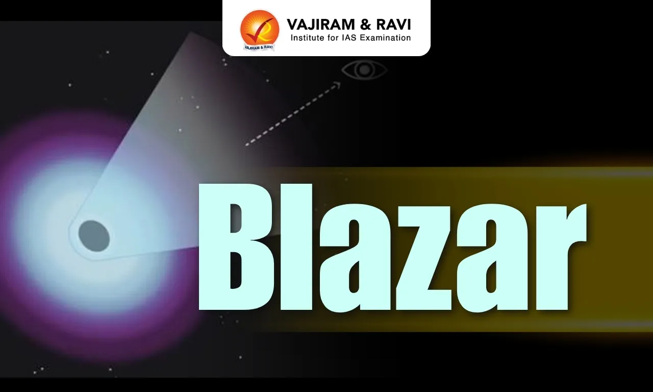
  • A blazar consists of a supermassive black hole, the accretion disk and the galaxy that hosts them.  
  • They are active galaxies powered by supermassive black holes at their centres, where matter falling towards the black hole releases large amounts of energy.
  • These systems also emit high-speed particle jets directed close to Earth’s line of sight, making them appear exceptionally bright.
  • A particularly extreme group of these objects are TeV blazars, which produce very-high-energy gamma rays reaching tera-electron volt energies.
  • Significance of Blazars
    • They are instrumental for exploring extreme physics that cannot be recreated on Earth.
    • The relativistic jets they produce offer clues about how matter behaves near supermassive black holes.
  • Challenges in Observation
    • As the powerful jets from blazars are directed almost toward Earth, their X-ray spectra are generally dominated by emission from the jet.
    • This makes it difficult to identify radiation from other parts of the galaxy, such as the accretion disk around the black hole.

Source: PIB

Blazar FAQ's

Q1: What are Blazars?

Ans: Blazars are among the most energetic objects in the Universe.

Q2: Where does Blazars form?

Ans: They typically form in young galaxies or galaxies undergoing a collision.

Krasheninnikov Volcano

Krasheninnikov Volcano

Krasheninnikov Volcano Latest News

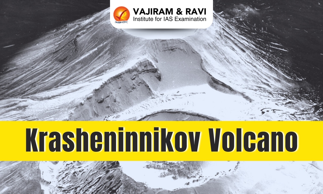
The Nasa-ISRO Nisar satellite recently captured detailed radar views of Russia's Krasheninnikov volcano as lava spread across Kamchatka.

About Krasheninnikov Volcano

  • It is an active stratovolcano located in the Eastern Kamchatka Peninsula, Russia.
    • The Kamchatka Peninsula lies along the Pacific “Ring of Fire.”
    • There are 114 volcanoes on the Kamchatka Peninsula that have erupted during the Holocene Epoch (approximately 12,000 years ago to the present).
  • The summit of the volcano reaches an elevation of 1,856 meters and lies within a collapse-originated caldera measuring 9 by 11 kilometers, dating back to 39,000 years ago. 
  • The volcanic complex consists of two adjacent main stratovolcano cones. 
  • The southern cone is crowned by a crater approximately 800 to 900 meters in diameter, while the northern cone is younger and exhibits a telescopic structure. 
  • Within the northern cone, smaller craters measuring 800 meters in diameter and lava cones have formed. 
  • The sides of both cones are covered with ejecta. 
  • Volcanic Activity:
  • Its last eruption took place about 400 or 600 years ago.
  • 2025 Eruption: Krasheninnikov volcano erupted on 2 August 2025, three days after a nearby magnitude 8.8 earthquake. Ash emissions reached an altitude of 20,000 ft.

Key Facts about NISAR Mission

  • NISAR (NASA-ISRO Synthetic Aperture Radar) is a joint Earth observation satellite mission between NASA and ISRO.
  • It is a satellite equipped with advanced radar instruments for Earth observation.
  • It was successfully launched on July 30, 2025, by ISRO's GSLV-F16 rocket from the Satish Dhawan Space Centre in Sriharikota, India.  
  • It marks the first-ever collaboration of its kind between India and the United States in radar-based Earth monitoring from space.
  • NISAR maps the entire Earth’s surface every 12 days, enabling high-frequency, precise, and repeat observations.
  • It is the first satellite mission to use two different radar frequencies (L-band and S-band) to measure changes in our planet's surface less than a centimeter across.  
  • NISAR will monitor earthquakes, volcanic activity, land deformation, and environmental changes, providing critical data for hazard assessment, disaster response, and resource management.

News: IT

Krasheninnikov Volcano FAQs

Q1: What type of volcano is Krasheninnikov Volcano?

Ans: It is an active stratovolcano.

Q2: Where is Krasheninnikov Volcano located?

Ans: In the eastern Kamchatka Peninsula of Russia.

Q3: How many main stratovolcano cones make up the Krasheninnikov volcanic complex?

Ans: Two adjacent stratovolcano cones.

Q4: What major geological event occurred near Krasheninnikov Volcano before its 2025 eruption?

Ans: A magnitude 8.8 earthquake occurred nearby.

Enquire Now