Researchers Discover Two New Plant Species in Arunachal Pradesh

Two New Plant Species

Two New Plant Species Latest News

Researchers recently identified two new plant species named Ophiorrhiza shidiensis and Ophiorrhiza pemae in Arunachal Pradesh’s Changlang district.

About Ophiorrhiza shidiensis and Ophiorrhiza pemae

  • They are two new plant species.
  • They were discovered in Arunachal Pradesh’s Changlang district.   
  • They belong to the Rubiaceae family.  
    • The Rubiaceae are a family of flowering plants, commonly known as the coffee, madder, or bedstraw family, consisting of 611 genera with more than 13150 species of herbs, shrubs, and trees.
  • Ophiorrhiza shidiensis is an erect, perennial herb that can grow up to one metre tall. 
    • It has pale green leaves on their undersides and tubular flowers that are white at the base, pale pink in the middle, and rose-pink towards the mouth. 
    • The species is named after “Shidi”, the traditional name for Gandhigram used by the Lisu (Yobin) community, referring to the locality where it was collected. 
  • Ophiorrhiza pemae is closely related to Ophiorrhiza himadrica but differs in several morphological characteristics, including its taller growth, larger leaves, distinctive leaf margins, and light pink to purplish flowers.

News: IT

Two New Plant Species FAQs

Q1: Which two new plant species were discovered in Arunachal Pradesh?

Ans: Ophiorrhiza shidiensis and Ophiorrhiza pemae.

Q2: To which plant family do Ophiorrhiza shidiensis and Ophiorrhiza pemae belong?

Ans: The Rubiaceae family.

Q3: What are the common names of the Rubiaceae family?

Ans: The coffee, madder and bedstraw family.

Climate Loss and Damage Fund Provisionally Sets Aside $21.6 Million for Nepal Floods

Fund for Responding to Loss and Damage (FRLD)

Fund for Responding to Loss and Damage Latest News

The Fund for Responding to Loss and Damage (FRLD) has provisionally set aside $21.6 million for Nepal's August 2026 floods, marking its first response to a specific disaster.

About Fund for Responding to Loss and Damage 

  • It is an international climate-finance fund set up to help developing countries that are particularly vulnerable to climate change respond to economic and non-economic losses, including from extreme weather and slow-onset events. 
  • It operates under the financial mechanism of the UN Framework Convention on Climate Change (UNFCCC).  
  • It was established at the 27th Conference of the Parties (COP 27) to the UNFCCC in Sharm el-Sheikh, Egypt, in 2022 and operationalised at COP28 in Dubai, United Arab Emirates, in 2023. 
  • A Board of 26 members was constituted in 2023, and subsequently, the Philippines was selected as the host of the Board in 2024, while the World Bank was selected to host the Secretariat, and as the Fund Trustee. 
  • The Board of the FRLD consists of members from Parties to the UNFCCC and Paris Agreement, with 12 members from developed country Parties and 14 from developing country Parties. 
  • By financing recovery initiatives from climate-related losses and damage, the Fund empowers communities to rebuild and adapt.  
  • It strives for country-led, locally driven solutions, ensuring interventions are aligned to country needs, priorities, and contexts. 

News: DTE

Fund for Responding to Loss and Damage FAQs

Q1: What is the Fund for Responding to Loss and Damage (FRLD)?

Ans: It is an international climate-finance fund that helps developing countries particularly vulnerable to climate change address economic and non-economic losses and damage.

Q2: Which countries are the primary beneficiaries of the Fund for Responding to Loss and Damage (FRLD)?

Ans: Developing countries that are particularly vulnerable to climate change.

Q3: Under which international convention does the Fund for Responding to Loss and Damage (FRLD) operate?

Ans: The United Nations Framework Convention on Climate Change (UNFCCC).

Q4: At which UNFCCC Conference of the Parties was the Fund for Responding to Loss and Damage (FRLD) established?

Ans: COP27, held in Sharm el-Sheikh, Egypt, in 2022.

Q5: Which institution serves as the trustee of the Fund for Responding to Loss and Damage (FRLD)?

Ans: The World Bank.

India Proposes Mandatory Emergency Braking for New Car Models from October 2030

Fund for Responding to Loss and Damage (FRLD)

Advanced Emergency Braking System Latest News

The Ministry of Road Transport and Highways (MoRTH) recently proposed making Advanced Emergency Braking Systems (AEBS) mandatory for all new car models from October 1, 2030, to help reduce road accidents.

About Advanced Emergency Braking System 

  • AEBS is an active vehicle safety technology designed to prevent collisions or reduce their severity. 
  • It is a combination of braking and sensor technology integrated into automobiles to recognise and prevent crashes.  
  • The system continuously monitors the road ahead, warns the driver when it detects a potential collision with another vehicle, pedestrian, or cyclist, and automatically applies the brakes if the driver fails to respond in time.
  • AEBS is a key feature of Advanced Driver Assistance Systems (ADAS), a collection of more than 100 electronic technologies designed to improve road safety. 
  • How does AEBS work?
    • AEBS operates continuously while a vehicle is moving. 
    • It uses a combination of radar sensors, cameras, or Light Detection and Ranging (LiDAR) technology, typically mounted near the front bumper or windscreen, to assess the distance from obstacles, their relative speed, and the time remaining before a potential collision.
    •  The system generally works in three stages:
      • Warning stage: When the system detects an obstacle approaching rapidly and calculates that a collision is imminent, it issues an audio-visual alert, such as a dashboard warning light and a beeping sound, prompting the driver to brake.
      • Partial or pre-braking stage: If the driver does not respond, the system may apply a brief, sharp brake pulse as a warning and pre-charge the braking system to maximise stopping power.
      • Full emergency braking stage: If the driver still fails to take action and a collision is imminent, AEBS automatically applies maximum braking force. 
  • AEBS can reduce the impact of various crashes, including head-on, rear-end, right-turn, and pedestrian collisions. 

Which countries have adopted AEBS? 

  • The European Union made AEBS mandatory for new commercial vehicle and truck models from 2015. 
    • Under updated safety regulations, the requirement was extended to every newly registered passenger vehicle sold by May 2024. 
  • Japan adopted AEBS early, making it legally mandatory for all new passenger vehicles from the year 2021. 
  • United States: Between 2016 and 2022, a voluntary agreement between the National Highway Traffic Safety Administration (NHTSA) and 20 major automakers led to basic AEBS becoming standard in more than 95 percent of new cars.
  • United Kingdom:
  • The United Kingdom requires AEBS as standard on all newly registered passenger cars. 
  • China has also seen widespread adoption of AEBS, with more than 60 per cent of new passenger vehicles sold in the country already featuring the technology.

News: BS

Advanced Emergency Braking System FAQs

Q1: What is the Advanced Emergency Braking System (AEBS)?

Ans: AEBS is an active vehicle safety technology designed to prevent collisions or reduce their severity.

Q2: What is the primary objective of Advanced Emergency Braking System (AEBS)?

Ans: To warn drivers of potential collisions and automatically apply the brakes if they fail to respond in time.

Q3: Which technologies are commonly used by Advanced Emergency Braking System (AEBS) to detect obstacles?

Ans: Radar sensors, cameras and Light Detection and Ranging (LiDAR) technology.

Q4: What factors does Advanced Emergency Braking System (AEBS) assess to identify a potential collision?

Ans: Distance from obstacles, relative speed and the time remaining before a potential collision.

World’s Largest Battery-Electric Vessel China Zorrilla Begins Commercial Service

China Zorrilla

China Zorrilla Latest News

The world’s largest battery-electric vessel, China Zorilla, recently entered commercial service after completing its maiden trip between Buenos Aires, Argentina, and Colonia, Uruguay.

About China Zorrilla

  • It is the world’s largest battery-electric vessel. 
  • Previously known as Incat Hull 096, it was built by Australian shipbuilding company Incat Tasmania for South American ferry operator Buquebus. 
  • It is named after China Zorrilla, the celebrated Uruguayan actress and theatre personality. 
  • It is sailing under the flag of Uruguay. 

China Zorrilla Features

  • Powered entirely by batteries, the largest electric ship ever constructed is 130 m long and 32 m wide and can accommodate 2100 passengers and 225 vehicles.     
  • It has three decks and a 2,300 m² duty-free retail complex. 
  • The energy system exceeds 40 MWh, with more than 250 metric tons of batteries. 
  • The system propels 8 electric motors connected to waterjets, giving it a speed of 25 knots. 
  • The vessel covers the 55-60 km route in 90 minutes, eliminating vibrations, toxic gases, and carbon emissions, while making the journey comfortable for passengers and harmless for the environment.

News: MI

China Zorrilla FAQs

Q1: What is China Zorrilla?

Ans: China Zorrilla is the world’s largest battery-electric vessel.

Q2: Which company built the China Zorrilla?

Ans: It was built by Incat Tasmania, an Australian shipbuilding company.

Q3: Under which country’s flag does the China Zorrilla sail?

Ans: It sails under the flag of Uruguay.

Q4: How many passengers and vehicles can the China Zorrilla accommodate?

Ans: It can accommodate 2,100 passengers and 225 vehicles.

Q5: What powers the China Zorrilla?

Ans: It is powered entirely by batteries.

Magnitude 6.5 Earthquake Strikes Japan’s Bonin Islands Region

Bonin Islands

Bonin Islands Latest News

A magnitude 6.5 earthquake recently struck the Bonin Islands region of Japan.

About Bonin Islands

  • The Bonin Islands, also known as the Ogasawara Islands, are some 30 volcanic islands and islets in the central Pacific Ocean, about 800 km southeast of Japan.  
  • The islands command a strategic position astride the Pacific approaches to East Asia.  
  • History:
    • The islands were claimed by Japan from the British in 1875 and placed under the Tokyo prefecture in 1880. 
    • In World War II the islands formed a major Japanese military stronghold until they were occupied by the U.S. Navy in 1945. 
    • The islands were administered by the U.S. military until 1968, when they were returned to Japan. 
  • Only a fraction of their total land area—73 sq.km.—is arable, the remainder being hilly and forested.  
  • The largest and principal island is Chichi (formerly Peel Island), the site of Omura, the capital of the group, and Futami-ko (Port Lloyd), the chief harbor.  
  • They have never been connected to a continental land mass: the island chain emerged from the sea floor as submarine volcanoes and has always been oceanic.
  • This origin makes the archipelago a laboratory for evolutionary divergence in isolation: 
    • The 195 endemic plant species (15% of all plant species known from the islands) and 100+ endemic land snail species represent separate evolutionary lineages from any continental ancestor. 
    • The 440 species of fish recorded in the surrounding reefs include species first described from Ogasawara that are not found anywhere else in the world. 
    • Bonin flying fox: A threatened fruit bat and the only endemic mammal of the Ogasawara Islands. 
  • They have been dubbed the “Galapagos of the Orient” due to the presence of many flora and fauna species that have evolved there independently. 
  • The Ogasawara Islands were added to UNESCO's list of World Natural Heritage sites in July 2011.

News: TOI

Bonin Islands FAQs

Q1: What are the Bonin Islands also known as?

Ans: The Bonin Islands are also known as the Ogasawara Islands.

Q2: Where are the Bonin Islands located?

Ans: They are located in the central Pacific Ocean, about 800 km southeast of Japan.

Q3: What is the topography of the Bonin Islands?

Ans: Most of the islands are hilly and forested, with only a small fraction of the land suitable for agriculture.

Q4: Why are the Bonin Islands considered important for evolutionary studies?

Ans: They have never been connected to a continental landmass, making them a natural laboratory for studying evolution in isolation.

Q5: What is the Bonin flying fox?

Ans: It is a threatened fruit bat and the only endemic mammal of the Ogasawara Islands.

Lake Untersee: How a Rare 2019 Flood Raised an Antarctic Lake by Two Metres

Lake Untersee

Lake Untersee Latest News

In January 2019, a rare glacial flood caused Lake Untersee to rise by two metres after a neighbouring lake released 17.5 million cubic metres of water.

About Lake Untersee

  • Lake Untersee, meaning "lower lake" in German, is a uniquely isolated freshwater lake in Antarctica. 
  • It is one of Antarctica’s largest and deepest surface lakes.
  • The lake’s maximum depth is thought to reach nearly 170 meters (558 feet). 
  • Despite being a surface lake, it remains frozen throughout the year because the region experiences mean annual temperatures of around- 10 degrees Celsius.
  • Several meters of thick ice seal the lake from the atmosphere. 
  • Sunlight can still penetrate the ice and warm the water beneath it, but strong winds and cold surface temperatures cause evaporation and sublimation that prevent the ice from melting significantly.
  • The lake’s water mainly comes from seasonal meltwater draining from the edges of the nearby Anuchin Glacier, which flows south from the Gruber Mountains. 
  • It is known for its distinctive water chemistry.   
  • Its ice-covered waters contain high levels of dissolved oxygen, very low levels of dissolved carbon dioxide, and a strongly alkaline, or basic, pH. 
  • It is one of the only perennially frozen lakes with a community of large, conical stromatolites. 
    • Stromatolites are layered microbial reef structures formed by communities of photosynthetic microbes, mainly cyanobacteria. 
    • These microbes grow slowly upward by trapping sediment on sticky surfaces and forming calcium carbonate mineral crusts. Over time, this process builds the layered formations. 
    • Stromatolites are some of the oldest biological structures on Earth, with fossils dating back more than 3 billion years.  
    • Untersee’s stromatolites grow unusually tall because they are sheltered from tides and waves beneath permanent ice, live in exceptionally clear waters with little sediment, grow toward limited light, and face little grazing. 
    • These conical stromatolites—as well as pinnacle and flat forms of the microbial communities—release oxygen that becomes trapped under the ice, increasing its concentration in the lake. 
  • The lake’s largest creatures are tardigrades—microscopic “water bear” invertebrates known for their ability to survive in extreme environments. 
  • Its icy environment and unusual chemistry make it a possible analogue for conditions on other worlds. 
  • Although Lake Unter-See appears stable, scientists have observed occasional changes.
    • During fieldwork in 2019, researchers noticed that the lake’s water levels had risen.

News: TOI

Lake Untersee FAQs

Q1: What is Lake Untersee?

Ans: Lake Untersee is an isolated freshwater lake in Antarctica.

Q2: Why is Lake Untersee significant?

Ans: It is one of Antarctica’s largest and deepest surface lakes and has unusual water chemistry and distinctive microbial structures.

Q3: Why does the ice on Lake Untersee not melt significantly?

Ans: Strong winds, cold surface temperatures, evaporation and sublimation limit significant ice melting.

Q4: What is the main source of water for Lake Untersee?

Ans: Its water mainly comes from seasonal meltwater draining from the nearby Anuchin Glacier.

Q5: What are the distinctive chemical characteristics of Lake Untersee?

Ans: Its waters have high dissolved oxygen, very low dissolved carbon dioxide and a strongly alkaline pH.

Forest Officials Seek Tree Surgery to Save Over 500 Girdled Trees in Chhattisgarh

Girdling

Girdling Latest News

In an attempt to save over 500 trees, which were girdled allegedly by encroachers in Karka village deep inside the Udanti Sitanadi Tiger Reserve (USTR) recently, the Chhattisgarh forest department is seeking expert help – in the form of a “surgery” or bridge-grafting technique.

About Girdling

  • Girdling is a commonly used habitat and forest management technique that deadens a tree without felling it for a specific purpose. 
  • Girdling involves the removal of bark and cambium from the target tree using continuous and connected cuts that completely encircle the entire tree. 
  • It destroys the cambium so no growth can occur and disrupts the flow of water and nutrients in the tree. 
  • As a result, roots are starved of nutrients, and the plant cannot grow more stems and foliage. 
  • Unless the plant can heal over the wound, it will die.
  • Uses:
    • Girdling is often used to control or eradicate large woody species where physical removal of woody biomass would be undesirable, unpopular, or cost prohibitive. 
    • Killing an undesirable tree in place by girdling also has the benefit of leaving standing snags for wildlife. 
    • Additionally, there is lower visual impact where the sudden removal of an entire stand would affect the area's aesthetics. Since die-off is gradual (taking months to years), the visual change in the area is slower. 
    • Killing mature trees slowly can also give replacement plantings time to grow.
    • This technique generally has a low impact on cultural resources, erosion, and surrounding habitat because it is highly selective and does not disturb soil. 

What is Cambium?

  • It is a layer of actively dividing cells between xylem (wood) and phloem (bast) tissues that is responsible for the secondary growth of stems and roots. 
    • In secondary growth, a plant grows wider. Contrast this to primary growth, in which a plant grows taller. 
  • Cambial cells divide to produce secondary xylem cells toward the central axis of the stem and secondary phloem cells toward the outside. 
  • The cambium originates from undifferentiated cells that have retained their embryonic capacity for continued growth and differentiation. 
  • A cambium may also form within callus tissues—masses of cells that grow over the injured surface of a wound, leading to healing. 
  • In a typical woody stem, the arrangement from outside to inside is:
    • Bark → Phloem → Vascular cambium → Xylem → Inner stem

What is Bridge-Grafting?

  • A bridge graft is an example of a repair graft. 
  • It is done to rescue established trees that have been girdled by mechanical damage or animals. 
  • Bridge-grafting consists of connecting the cambium layers above and below the girdled area. 
  • This process restores the flow of carbohydrates from the leaves down to the roots, thereby allowing the tree to continue its normal life processes. 
  • The connection or bridge is usually made with scions (Bridge Wood). Scions are taken from dormant one-year-old stems. 

News: IE

Girdling FAQs

Q1: What is girdling?

Ans: Girdling is a habitat and forest management technique used to kill a tree without felling it.

Q2: How is girdling carried out?

Ans: Girdling involves removing the bark and cambium through continuous cuts that completely encircle the tree.

Q3: How does girdling affect a tree’s growth?

Ans: It destroys the cambium, preventing normal growth and disrupting the transport of nutrients.

Q4: What is the main difference between girdling and felling a tree?

Ans: Girdling kills a tree in place, whereas felling involves cutting it down and removing or leaving the felled tree.

Magnitude 6.9 Earthquake Strikes Near Vanuatu; Tsunami Warning Lifted

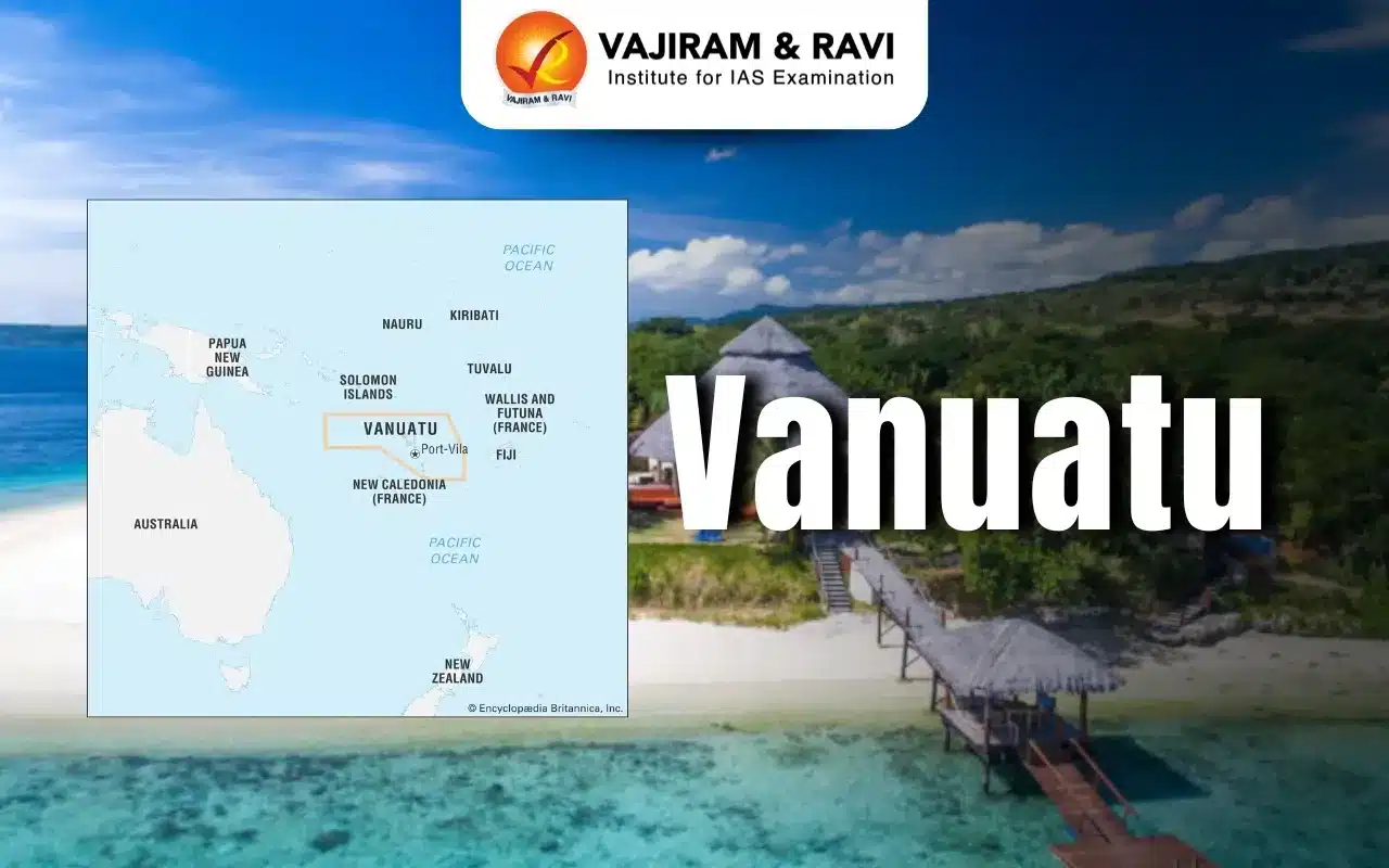
Vanuatu

Vanuatu Latest News

A preliminary magnitude 6.9 earthquake recently hit off the coast of Vanuatu, a South Pacific island nation, according to the US Geological Survey, prompting a tsunami warning for the area that was later rescinded.

About Vanuatu

  • Vanuatu, officially the Republic of Vanuatu, is an island country located in the South Pacific Ocean. 
  • It is a Melanesian archipelago made up of 83 islands, of which only 65 are inhabited. Most islands are volcanic in origin. The largest island is Espíritu Santo. 
  • The islands extend north-south for some 650 km in an irregular Y shape.
  • They lie about 800 kilometres west of Fiji and nearly 1800 kilometres east of Australia.  
  • Geography: 
    • A diverse relief—ranging from rugged mountains and high plateaus to rolling hills and low plateaus, with coastal terraces and offshore coral reefs—characterizes the islands.
    • The country is home to several active volcanoes, including Mount Yasur, which is one of the world’s most accessible active volcanoes. 
  • History:  
    • In the 1880s, France and the United Kingdom claimed parts of the islands. 
    • In 1906, they decided to manage the islands together. This joint rule was called the New Hebrides Anglo-French Condominium.
    • In the 1970s, people in Vanuatu started a movement to become independent.
    • The Republic of Vanuatu was created in 1980.
  • Form of Government:  Parliamentary democracy.
  • Capital: Its capital and largest city is Port Vila, located on Efate Island.
  • Currency: The vatu is the currency of Vanuatu.
  • People: 
    • The population of Vanuatu is 94% indigenous Melanesian.
    • There are also small minorities of Europeans, Micronesians, Chinese, and Vietnamese. 
  • Language: 
    • The national language is Bislama (a Creole language). 
    • The official languages are Bislama, English, and French.
  • Economy: 
  • The economy is based on agriculture, tourism, fishing, and offshore financial services, with kava exports playing a significant role.
  • Vanuatu does not have income tax, withholding tax, capital gains tax, inheritance tax, or exchange control. 
  • VAT, tourism, and agricultural exports contribute to the national income.
  • Passports provide a major source of government revenues.
  • Vanuatu offers a citizenship-by-investment programme, allowing foreigners to obtain citizenship in exchange for a financial contribution, typically for around $1,50,000 USD.
    • Vanuatu passport holders can travel to 56 countries without a visa, making its citizenship-by-investment programme a highly attractive scheme.

News: TELE

Vanuatu FAQs

Q1: Where is Vanuatu located?

Ans: Vanuatu is an island country in the South Pacific Ocean.

Q2: How many islands make up the Vanuatu archipelago?

Ans: Approximately 83 islands.

Q3: Which is the largest island of Vanuatu?

Ans: Espíritu Santo

Q4: In which year did Vanuatu gain independence?

Ans: 1980.

Q5: What is the capital and largest city of Vanuatu?

Ans: Port Vila.

Ukraine Reveals Details of Russia’s Reported Filin Cruise Missile

Filin Missile

Filin Missile Latest News

Ukraine’s military intelligence agency, HUR, revealed details of Russia’s reported Filin cruise missile recently, releasing a 3D model and information about its components and onboard electronic systems.

About Filin Missile

  • It is a low-cost, ground-launched, jet-powered cruise missile developed by Russia. 
  • The missile is produced by NPO Molniya, part of Russia’s Tactical Missiles Corporation.

Filin Missile Features

  • It features carbon fiber and glass fiber reinforced composite materials in its fuselage, and various structural components are manufactured using 3D printing technology. 
  • The missile measures about 3.5 meters in length with a wingspan of roughly 3 meters.
  • The missile is launched from a ground-based launcher using a solid-propellant booster before its main engine takes over. The missile uses an R500 turbojet engine. 
  • It can reach a top speed of 800 km/hr and has a range of up to 1,200 kilometers.
  • It is designed to fly at extremely low altitudes but can also climb to approximately 6 kilometers.  
  • It carries a fairly small warhead of either 50 or 100 kilograms. 
  • Navigation is provided by a Chinese-made inertial navigation system together with a 16-channel Kometa satellite navigation module.

News: HT

Filin Missile FAQs

Q1: What is the Filin missile?

Ans: The Filin is a low-cost, ground-launched, jet-powered cruise missile.

Q2: Which country developed the Filin missile?

Ans: Russia.

Q3: Which company produces the Filin missile?

Ans: NPO Molniya, part of Russia’s Tactical Missiles Corporation.

Q4: What is the maximum reported range of the Filin missile?

Ans: Up to 1,200 kilometres.

India and Sri Lanka Launch SAMHiTA Project to Preserve South Asian Manuscripts

SAMHiTA Project

SAMHiTA Project Latest News

India and Sri Lanka are strengthening their cultural cooperation through the preservation of their shared Buddhist heritage, with the launch of the SAMHiTA Project at Colombo’s Gangaramaya Temple.

About SAMHiTA Project

  • The SAMHiTA (South Asian Manuscript Histories and Textual Archive) Project is an initiative to create a relational database and digital archive of Indian and broadly South Asian manuscripts housed in libraries, archives, and other repositories outside India, through collaboration with institutional partners. 
  • The word ‘samhita’ in Sanskrit means ‘collection’ or ‘compilation’. SAMHiTA’s goal is to consolidate information dispersed across institutions on an online platform accessible to all. 
  • The information collected will be shared on PANDiT: Prosopographical Database of Indic Texts and Records, a database on South Asian intellectual history. 
  • The initiative is being undertaken by the India International Centre in New Delhi, with grant assistance from the Government of India and is supported by the Ministry of External Affairs (MEA).
  • It aims to digitise ancient manuscripts and preserve their historical, religious, and cultural knowledge for future generations. 
  • It is the first attempt to bring together repositories from outside India and South Asia on a common platform.

News: DD

SAMHiTA Project FAQs

Q1: What is the SAMHiTA Project?

Ans: It is an initiative to create a relational database and digital archive of Indian and South Asian manuscripts preserved in repositories outside India.

Q2: What is the main objective of the SAMHiTA Project?

Ans: To consolidate information about manuscripts dispersed across different institutions on a common online platform accessible to all.

Q3: Which database will host information collected through the SAMHiTA Project?

Ans: PANDiT (Prosopographical Database of Indic Texts and Records).

Q4: Which institution is undertaking the SAMHiTA Project?

Ans: The initiative is being undertaken by the India International Centre in New Delhi, with grant assistance from the Government of India.

Enquire Now