What’s in Today’s Article?
- Why in News?
- What is the Line of Actual Control (LAC)?
- LAC vs Line of Control (LoC) with Pakistan
- Disagreement over the LAC
- Why are these Claim Lines Controversial in Ladakh?
- Current Arrangement to Reconcile Differences over LAC
- The Plans for Expeditious De-escalation along the LAC in Eastern Ladakh
- Legacy Issues that Need to be Resolved
Why in News?
- The Indian PM and Chinese President agreed on the sidelines of the 15th BRICS Summit to intensify efforts for expeditious disengagement and de-escalation along the LAC in eastern Ladakh.
- With this, the spotlight is now on the exact contours of plans being drawn up by military commanders on the ground to pull back troops.
What is the Line of Actual Control (LAC)?
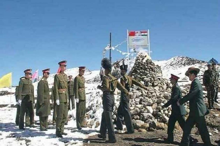
- The LAC is the demarcation that separates Indian-controlled territory from Chinese-controlled territory.
- It is divided into three sectors: the eastern sector which spans Arunachal Pradesh and Sikkim, the middle sector in Uttarakhand and Himachal Pradesh, and the western sector in Ladakh.
- India considers the LAC to be 3,488 km long, while the Chinese consider it to be only around 2,000 km.
- India’s claim line is the line seen in the official boundary marked on the maps as released by the Survey of India, including both Aksai Chin and Gilgit-Baltistan. This means LAC is not the claim line for India.
- In China’s case, LAC is the claim line except in the eastern sector, where it claims the entire Arunachal Pradesh as South Tibet.
LAC vs Line of Control (LoC) with Pakistan:
- The LoC emerged from the 1948 ceasefire line negotiated by the UN after the Kashmir War.
- It was designated as the LoC in 1972, following the Shimla Agreement between the two countries (India and Pakistan).
- It is delineated on a map signed by DGMOs of both armies and has the international sanctity of a legal agreement.
- On the other hand, the LAC is only a concept. It is not agreed upon by the two countries, neither delineated on a map or demarcated on the ground.
Disagreement over the LAC:
- The major disagreements are in the western sector where the LAC emerged from two letters written by Chinese PM Zhou Enlai to PM Jawaharlal Nehru in 1959, after he had first mentioned such a ‘line’ in 1956.
- After the 1962 War, the Chinese claimed they had withdrawn to 20 km behind the LAC of 1959, which coincides with the so-called McMahon Line in the eastern sector.
- India’s Response to China’s Designation of the LAC:
- India rejected the concept of LAC in both 1959 and 1962, as it is the line China has created.
- The Chinese line was a disconnected series of points on a map that could be joined up in many ways.
- The line should omit gains from aggression in 1962 and therefore should be based on the actual position on September 8, 1962 before the Chinese attack.
- This vagueness of the Chinese definition left it open for China to continue its creeping attempt to change facts on the ground by military force.
- During the Doklam crisis in 2017, the Chinese Foreign Ministry spokesperson urged India to abide by the “1959 LAC”.
Why are these Claim Lines Controversial in Ladakh?
- Aksai Chin in Ladakh province of the princely state of J&K was not part of British India, although it was a part of the British Empire.
- Thus, the eastern boundary was well defined in 1914 (when the Shimla Agreement on the McMahon Line was signed by British India) but in the west in Ladakh, it was not.
Current Arrangement to Reconcile Differences over LAC:
- India formally accepted the concept of the LAC when the Indian PM paid a return visit to Beijing in 1993 (after Chinese Premier Li Peng’s 1991 visit to India).
- The two sides signed the Agreement to Maintain Peace and Tranquility at the LAC.
- The reference to the LAC was unable to make it clear that it was referring to the LAC at the time the agreement was signed, not the LAC of 1959 or 1962.
- To reconcile the differences about some areas, the two countries agreed that the Joint Working Group on the border issue would take up the task of clarifying the alignment of the LAC.
The Plans for Expeditious De-escalation along the LAC in Eastern Ladakh:
- The extent of disengagement and where on the LAC it will take place is not immediately clear.
- However, various modalities have been prepared for possible limited disengagement in phases.
- For example, since 2020, Corps Commanders of India and China have been discussing resolution of the flashpoints along the LAC.
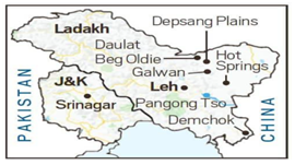
- The talks led to some forward movement with both sides deciding to pull back troops and dismantle temporary structures from the Galwan Valley.
- Disengagement in most of these areas led to the creation of buffer zones – this stops troops of both sides from accessing areas which they patrolled earlier.
Legacy Issues that Need to be Resolved:
- Other than these friction points, the legacy issues of Depsang Plains and Demchok – which predate the 2020 incursions by the Chinese PLA – continue to fester.
- The Depsang Plains are located close to the strategically important Daulat Beg Oldie. The Depsang Plains issue began in 2013 when China carried out an 18-km incursion in the area.
- Despite the two countries agreeing then to go back from their positions, the PLA troops did not vacate the area completely.
- In Demchok, which is in the southern part of eastern Ladakh, the problem is mainly at the ChardingNinglung Nullah (CNN) junction.
- In multiple instances, the PLA also stopped Indian graziers at the Saddle Pass at the CNN junction, well within India’s perception of the LAC.
Q1) Who are the new entrants to the BRICS grouping?
Argentina, Egypt, Ethiopia, Iran, Saudi Arabia and the United Arab Emirates have all been invited to become members of BRICS at the 15th BRICS Summit in Johannesburg, South Africa.
Q2) Where is Doklam located?
Doklam plateau is an area in Bhutan, located on the tri-junction of Tibet-Bhutan-India border lies between Chumbi Valley in the north and Sikkim to the west. In 2017, a military standoff occurred between China and India, as China attempted to extend a road on the Doklam plateau.
Source: India-China LAC | Buffer zones to Depsang to Demchok: Spotlight on pullback plan, the extent | IE
Last updated on February, 2026
→ UPSC Notification 2026 is now out on the official website at upsconline.nic.in.
→ UPSC IFoS Notification 2026 is now out on the official website at upsconline.nic.in.
→ UPSC Calendar 2026 has been released.
→ Check out the latest UPSC Syllabus 2026 here.
→ Join Vajiram & Ravi’s Interview Guidance Programme for expert help to crack your final UPSC stage.
→ UPSC Mains Result 2025 is now out.
→ UPSC Prelims 2026 will be conducted on 24th May, 2026 & UPSC Mains 2026 will be conducted on 21st August 2026.
→ The UPSC Selection Process is of 3 stages-Prelims, Mains and Interview.
→ Prepare effectively with Vajiram & Ravi’s UPSC Prelims Test Series 2026 featuring full-length mock tests, detailed solutions, and performance analysis.
→ Enroll in Vajiram & Ravi’s UPSC Mains Test Series 2026 for structured answer writing practice, expert evaluation, and exam-oriented feedback.
→ Join Vajiram & Ravi’s Best UPSC Mentorship Program for personalized guidance, strategy planning, and one-to-one support from experienced mentors.
→ UPSC Result 2024 is released with latest UPSC Marksheet 2024. Check Now!
→ UPSC Toppers List 2024 is released now. Shakti Dubey is UPSC AIR 1 2024 Topper.
→ Also check Best UPSC Coaching in India


