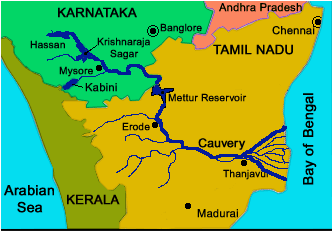
About Cauvery basin
- It extends over states of Tamil Nadu, Karnataka, Kerala and Union Territory of Puducherry.
- It is bounded by the Western Ghats on the west, by the Eastern Ghats on the east and the south and by the ridges separating it from Krishna basin and Pennar basin on the north.
- The Cauvery River is one of the major rivers of the peninsula.
- Origin: It rises at an elevation of 1,341 m at Talakaveri on the Brahmagiri range near Cherangala village of Kodagu district of Karnataka.
- The river drains into the Bay of Bengal at Poompuhar in the Mayiladuthurai district of Tamil Nadu.
- Major left bank tributaries: Harangi, the Hemavati, the Shimsha and the Arkavati.
- Major right bank tributaries: Lakshmantirtha, the Kabbani, the Suvarnavati, the Bhavani, the Noyil and the Amaravati
- The basin can be divided into three parts – the Western Ghats, the Plateau of Mysore and the Delta.
- The delta area is the most fertile tract in the basin.
- The principal soil types found in the basin are black soils, red soils, laterites, alluvial soils, forest soils and mixed soils. Red soils occupy large areas in the basin. Alluvial soils are found in the delta areas.
- National Parks in this basin: Bandipur National Park, Nagarhole National Park and Bannerghatta National Park.
Q1) What is a river basin?
It is the area of land over which surface run-off flows via streams, rivers, and lakes into the sea. A river basin sends all the water that falls within it to a central river, and from there to the ocean. A river basin drains all of the land around a major river. Basins are divided into watersheds, or land areas that surround a small, river or lake.
Last updated on November, 2025
→ Check out the latest UPSC Syllabus 2026 here.
→ Join Vajiram & Ravi’s Interview Guidance Programme for expert help to crack your final UPSC stage.
→ UPSC Mains Result 2025 is now out.
→ UPSC Notification 2026 is scheduled to be released on January 14, 2026.
→ UPSC Calendar 2026 is released on 15th May, 2025.
→ The UPSC Vacancy 2025 were released 1129, out of which 979 were for UPSC CSE and remaining 150 are for UPSC IFoS.
→ UPSC Prelims 2026 will be conducted on 24th May, 2026 & UPSC Mains 2026 will be conducted on 21st August 2026.
→ The UPSC Selection Process is of 3 stages-Prelims, Mains and Interview.
→ UPSC Result 2024 is released with latest UPSC Marksheet 2024. Check Now!
→ UPSC Prelims Result 2025 is out now for the CSE held on 25 May 2025.
→ UPSC Toppers List 2024 is released now. Shakti Dubey is UPSC AIR 1 2024 Topper.
→ UPSC Prelims Question Paper 2025 and Unofficial Prelims Answer Key 2025 are available now.
→ UPSC Mains Question Paper 2025 is out for Essay, GS 1, 2, 3 & GS 4.
→ UPSC Mains Indian Language Question Paper 2025 is now out.
→ UPSC Mains Optional Question Paper 2025 is now out.
→ Also check Best IAS Coaching in Delhi


