
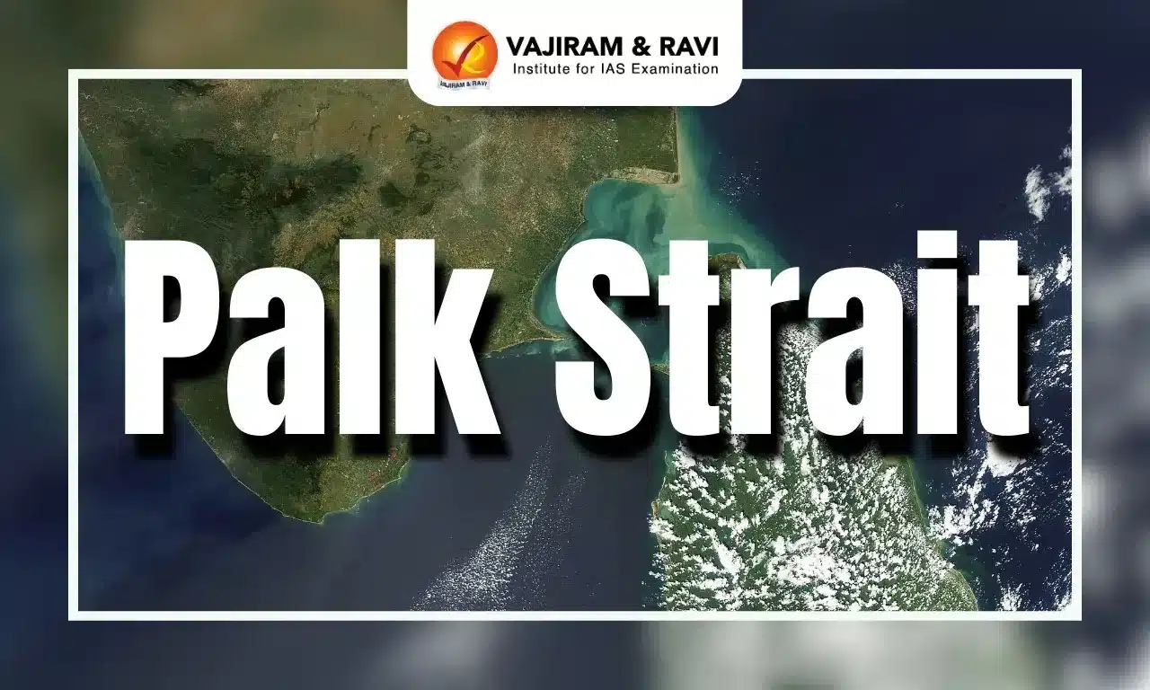
Palk Strait Latest News
In a fresh incident, 32 fishermen from Tamil Nadu were arrested by Sri Lankan Navy personnel on charges of poaching along the Palk Straits recently.
About Palk Strait
- It is an inlet of the Bay of Bengal between southeastern India and northern Sri Lanka.
- It is bounded on the south by Pamban Island (India), Adam’s (Rama’s) Bridge (a chain of shoals), the Gulf of Mannar, and Mannar Island (Sri Lanka).
- The southwestern portion of the strait is also called Palk Bay.
- The strait is named after Robert Palk, who was a governor of Madras Presidency (1755-1763) during the Company Raj period.
- The strait is 40 to 85 miles wide, 85 miles long, and less than 330 feet (100 metres) deep.
- It receives several rivers, including the Vaigai (India), and it contains many islands on the Sri Lankan side.
- The port of Jaffna, the commercial centre for northern Sri Lanka, lies on the strait.
- The shoals and numerous islands long have limited transit through the strait to smaller vessels.

Palk Strait FAQs
Q1. Which strait separates Sri Lanka from India?
Ans. The Palk Strait separates India from Sri Lanka.
Q2. Where is Ram Setu?
Ans. Ram Setu (Adam’s Bridge) is a chain of limestone shoals connecting Rameswaram Island (India) to Mannar Island (Sri Lanka) across the Palk Strait.
Q3. Which two seas are connected by Palk Strait?
Ans. It connects the Bay of Bengal in the northeast with the Gulf of Mannar in the southwest.
Source: TH
Last updated on November, 2025
→ Check out the latest UPSC Syllabus 2026 here.
→ Join Vajiram & Ravi’s Interview Guidance Programme for expert help to crack your final UPSC stage.
→ UPSC Mains Result 2025 is now out.
→ UPSC Notification 2026 is scheduled to be released on January 14, 2026.
→ UPSC Calendar 2026 is released on 15th May, 2025.
→ The UPSC Vacancy 2025 were released 1129, out of which 979 were for UPSC CSE and remaining 150 are for UPSC IFoS.
→ UPSC Prelims 2026 will be conducted on 24th May, 2026 & UPSC Mains 2026 will be conducted on 21st August 2026.
→ The UPSC Selection Process is of 3 stages-Prelims, Mains and Interview.
→ UPSC Result 2024 is released with latest UPSC Marksheet 2024. Check Now!
→ UPSC Prelims Result 2025 is out now for the CSE held on 25 May 2025.
→ UPSC Toppers List 2024 is released now. Shakti Dubey is UPSC AIR 1 2024 Topper.
→ UPSC Prelims Question Paper 2025 and Unofficial Prelims Answer Key 2025 are available now.
→ UPSC Mains Question Paper 2025 is out for Essay, GS 1, 2, 3 & GS 4.
→ UPSC Mains Indian Language Question Paper 2025 is now out.
→ UPSC Mains Optional Question Paper 2025 is now out.
→ Also check Best IAS Coaching in Delhi