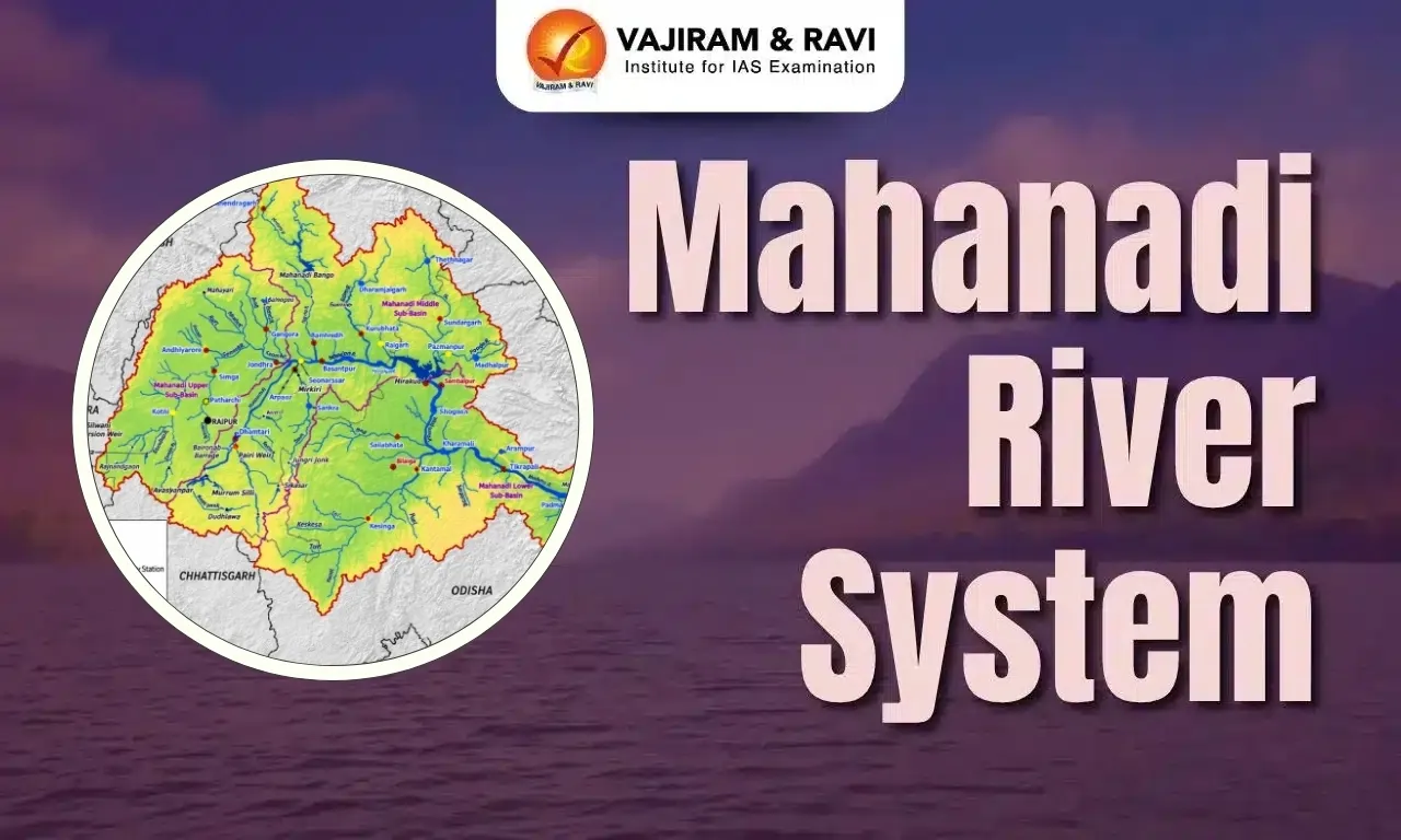
The Mahanadi River System is one of the major east-flowing river systems of Peninsular India, originating near Pharsiya in the Sihawa region of Chhattisgarh and flowing for about 851 km before draining into the Bay of Bengal. Its basin extends primarily across Chhattisgarh and Odisha, with smaller portions in Jharkhand, Maharashtra and Madhya Pradesh. The river and its tributaries, including the Seonath, Hasdeo, Mand, Ib, Jonk, Ong and Tel, form an important drainage network of east-central India.
The Mahanadi River System supports extensive agriculture, irrigation, hydropower generation, industries, drinking-water supply and diverse ecosystems. The Hirakud Dam is a major multipurpose project on the river. However, floods, droughts, pollution, salinity, climate variability and interstate water-management issues pose significant challenges.
Mahanadi River System Origin
The Mahanadi River originates in the highlands of the Dandakaranya region in Chhattisgarh, India. Its source is located near Pharsiya village in the Raipur district, at an elevation of approximately 442 metres (1,450 feet) above sea level.
Mahanadi River System Basin
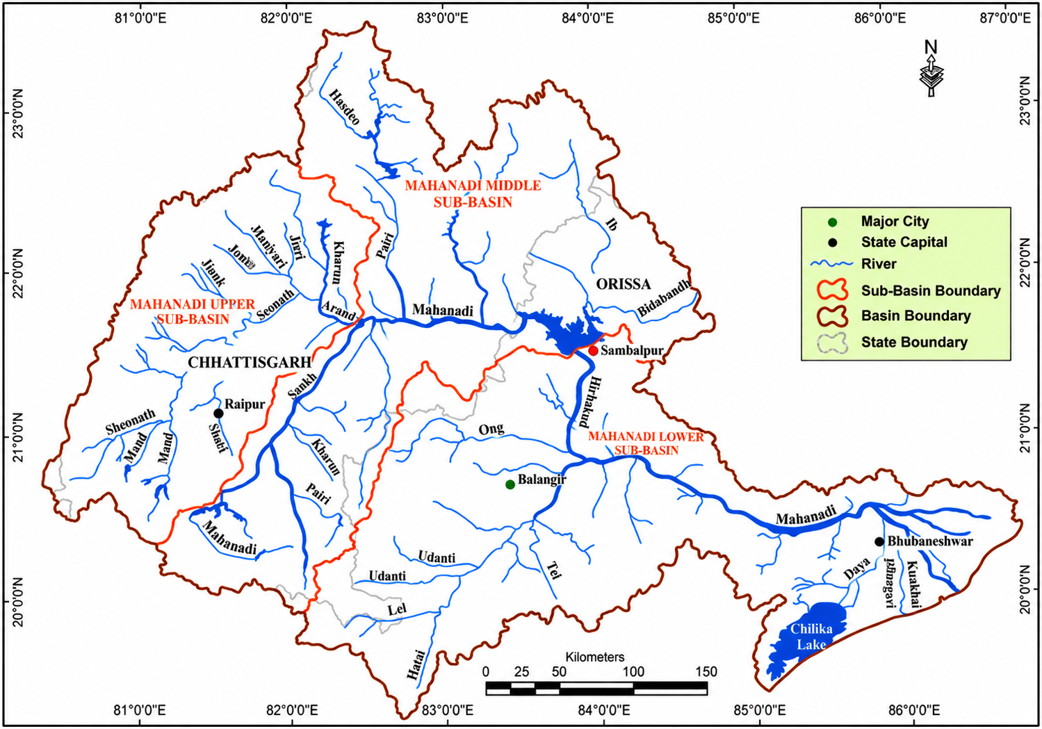
The Mahanadi River basin covers major parts of Chhattisgarh and Odisha, along with smaller portions of Jharkhand, Maharashtra and Madhya Pradesh.
- The India-WRIS GIS-based assessment gives the basin area as approximately 139,681.51 sq km, while the report notes that the CWC-reported basin area is 141,589 sq km. The basin extends between approximately 80°28′–86°43′ E longitude and 19°8′–23°32′ N latitude.
- The basin is geographically bounded by the Central India hills in the north, the Eastern Ghats towards the south and east, and the Maikala Hill Range in the west.
- It has a broadly circular configuration, with a maximum length of about 587 km and a maximum width of around 400 km.
States Covered by the Mahanadi Basin
The Mahanadi River basin extends across five states, with Chhattisgarh and Odisha accounting for almost the entire basin area.
- Chhattisgarh: Approximately 52.42% of the basin lies in Chhattisgarh.
- Odisha: Approximately 47.14% of the basin lies in Odisha.
- Maharashtra: Contributes about 0.23%.
- Madhya Pradesh: Contributes about 0.11%.
- Jharkhand: Contributes about 0.10%.
Mahanadi River Sub-Basins
The Mahanadi River basin is divided into Upper, Middle and Lower sub-basins, which together represent the major hydrological divisions of the river system.
- The India-WRIS assessment identifies three sub-basins: Upper Mahanadi, Middle Mahanadi and Lower Mahanadi. The lower sub-basin is the largest, followed by the middle and upper sub-basins.
- Upper Mahanadi Sub-Basin: Covers about 29,796.64 sq km and is primarily drained by the Seonath, Arpa, Kurung and Sakri rivers.
- Middle Mahanadi Sub-Basin: Covers about 51,895.91 sq km and includes the Mahanadi along with the Jonk, Ib, Bhedan and Mand drainage systems.
- Lower Mahanadi Sub-Basin: Covers about 57,958.88 sq km and includes the Ong, Tel, Hati and Daya drainage systems.


Mahanadi River System Tributaries
The Mahanadi River is the third-largest river in central India, following the Godavari and Krishna rivers. Its tributaries are classified into two categories: right-bank and left-bank tributaries. The right tributaries of the Mahanadi include Jonk, Ong, and Tel, while the left tributaries consist of Seonath, Hasdeo, Mand, and Ib.
| Mahanadi River System Tributaries | |
| River Name | Description |
|
Jonk River |
The Jonk River originates in the Khariar (Sunabeda) hills of Odisha, flows through Odisha and Chhattisgarh, and joins the Mahanadi near Shivrinarayan. It covers a distance of about 182 to 196 km. |
|
Ong River |
A tributary of the Mahanadi, originating from the Eastern Ghats and flowing through Odisha, contributes significantly to the state's water resources. |
|
Tel River |
Originates in the Kalahandi district of Odisha and meets the Mahanadi near Sonpur. It has a total length of 296 km. |
|
Seonath River |
It has its source at Panabaras Hill (625 m) and flows in a north-easterly direction. It serves as an essential water source for the Durg district in Chhattisgarh. |
|
Hasdeo River |
Originates from the hills of Chhattisgarh and flows southward, passing through Bilaspur and Korba districts before merging with the Mahanadi. It is associated with the Korba coalfield region. |
|
Mand River |
Originates from a 686-metre-high hill near Surguja district and stretches for about 242 km before joining the Mahanadi near Chandrapur. |
|
Ib River |
It has its origin in the hills of Raigarh district in Chhattisgarh and is an important tributary of the Mahanadi River. |
Mahanadi River System Major Dams and Reservoirs
The Mahanadi River system has an extensive network of dams and reservoirs supporting irrigation, hydropower generation, drinking water supply and flood management.
- Hirakud Dam: Located on the Mahanadi in Odisha, Hirakud is a major multipurpose project with a total length of 25.79 km, including a 4.8 km-long main dam.
- Its foundation stone was laid by Prime Minister Jawaharlal Nehru on 12 April 1948, and construction was completed in June 1955.
- The dam was primarily built for flood control and drought mitigation, protecting the lower Mahanadi delta from floods and supporting irrigation in the region.
- It has since contributed significantly to agricultural productivity, flood management and regional economic development.
- Hasdeo Bango Dam: Located on the Hasdeo River, a tributary of the Mahanadi, it is identified as the highest dam in the basin, with a height of about 87 m.
- Ravishankar Sagar (Gangrel Dam): It forms part of the Mahanadi Reservoir Complex, together with Dudhwaha and Murumsilli dams.
- Dudhwaha and Murumsilli: These reservoirs are components of the Mahanadi Reservoir Complex, which is supported by the New Rudri Barrage.
- Tandula Dam: Located on the Tandula River in Chhattisgarh, the project is an important irrigation project and primarily benefits Durg district.
Mahanadi River System Importance
The Mahanadi River system is important for agriculture, hydropower, drinking water, flood management, industry, ecosystem and the socioeconomic development of its basin states.
- Irrigation: The Mahanadi basin supports extensive irrigation through major and medium projects, including the Hirakud Irrigation Project, which benefits agricultural areas of Sambalpur, Bargarh, Bolangir and Sonepur districts.
- Hydropower: The river system contributes significantly to electricity generation through projects such as the Hirakud Hydroelectric Project.
- Flood management: Hirakud Dam plays a major role in regulating downstream flows and moderating floods, particularly in the lower Mahanadi basin and deltaic areas of Odisha that are vulnerable to flooding.
- Drinking water: Mahanadi and its tributaries provide surface-water resources for domestic and municipal requirements across settlements in Chhattisgarh and Odisha, making the basin important for the water security of its population.
- Industry: The basin's water resources support industrial activities in Chhattisgarh and Odisha, particularly in areas associated with mining, metals, power generation and other water-dependent industries.
- Agriculture: Agriculture is a major land use in the basin, with the report recording about 54.27% of the basin under agricultural land in the cited land-use assessment, according to data from India-WRIS and related geographic reports. Irrigation from reservoirs and canals further supports crop production.
- Ecology: The Mahanadi system supports diverse riverine ecosystems, reservoirs, wetlands, forests and deltaic environments. Its lower reaches and delta are particularly important for aquatic and wetland biodiversity.
- Tourism: Major water bodies and river landscapes provide opportunities for water-based tourism and recreation, while protected areas within the basin add wildlife-tourism value.
- Socioeconomic development: Projects such as Hirakud, Hasdeo Bango and the Mahanadi Reservoir Complex contribute simultaneously to irrigation, water storage, power generation and flood management, making the river system an important foundation for regional development.
Mahanadi River System Challenges
Challenges to the Mahanadi River system arise from floods, droughts, climatic variability, waterlogging, salinity, increasing water demand and limitations in water-quality data across the basin.
- Flooding in the delta: The lower Mahanadi and deltaic regions are vulnerable to severe floods because some river channels have inadequate carrying capacity.
- Drought in central regions: The basin faces a contrasting problem of drought in its central region, creating seasonal water stress for agriculture and other water-dependent activities.
- Cyclones in the coastal region: The eastern coastal location makes the lower basin vulnerable to cyclones, which can intensify flooding and affect settlements and agricultural areas.
- Rainfall and climate variability: Changes in rainfall, evaporation and other hydrological parameters can affect the availability and reliability of water resources in the basin.
- Waterlogging: Irrigated command areas have experienced waterlogging problems, particularly in areas served by major and medium irrigation projects.
- Soil salinity: The CWC–ISRO assessment identified about 213.60 sq km of salt-affected area in the basin, indicating a challenge for agricultural productivity and soil management.
- Increasing water demand: The Mahanadi serves agriculture, hydropower, drinking water, industry and other sectors. Growing and competing demands make integrated basin-level water management increasingly important.
- Heavy dependence on irrigation infrastructure: Large parts of the basin depend on reservoirs and canal networks such as Hirakud, Hasdeo Bango, Tandula and Mahanadi Reservoir Complex. This makes efficient operation, maintenance and equitable water distribution important.
- Groundwater management: Although the basin has substantial groundwater potential, groundwater use and availability vary spatially. Continuous monitoring is therefore necessary to maintain groundwater security.
- Inadequate water-quality data: The India-WRIS report specifically notes that water-quality data for the basin is not adequate, creating limitations for comprehensive assessment and management of water quality.
- Inter-state water management: The basin extends across Chhattisgarh, Odisha, Jharkhand, Maharashtra and Madhya Pradesh, requiring coordination among states for managing water resources and projects.
- Mahanadi water dispute: Differences between Odisha and Chhattisgarh over upstream water utilisation, projects and downstream flows highlight the need for transparent data-sharing and cooperative basin management.
Mahanadi River System Way Forward
The Mahanadi River system requires integrated basin management, climate-resilient planning, efficient water use, flood and drought management, ecosystem protection and stronger interstate coordination.
- Integrated River Basin Management: Treat the Mahanadi as a single hydrological unit and coordinate the management of surface water, groundwater, irrigation, hydropower and ecological requirements across the basin.
- Strengthen flood management: Improve flood forecasting, reservoir operation and downstream drainage capacity, particularly in the Mahanadi delta, which is vulnerable to severe flooding.
- Drought-resilient water management: Develop better water-storage, groundwater-recharge and watershed-management measures in the central parts of the basin, which are prone to drought.
- Climate-resilient planning: Incorporate changing rainfall, evaporation and other hydrological parameters into reservoir operation, irrigation planning and long-term water-resource management.
- Improve irrigation efficiency: Modernise canal networks and promote efficient irrigation practices to reduce water losses. Existing systems such as Hirakud, Hasdeo Bango, Tandula and Mahanadi Reservoir Complex should be managed for greater water-use efficiency.
- Address waterlogging and salinity: Improve drainage in irrigation commands and adopt appropriate soil and water-management practices to control waterlogging and salt-affected areas, which have already been identified in the basin.
- Strengthen water-quality monitoring: Expand monitoring stations and improve the availability of water-quality data, since the India-WRIS report notes that existing water-quality information is inadequate.
- Conserve ecosystems: Protect wetlands, riverine ecosystems, forests and deltaic habitats while ensuring that water-resource development does not undermine ecological functions.
- Improve interstate coordination: Since the basin extends across five states, effective cooperation and data sharing among Chhattisgarh, Odisha, Jharkhand, Maharashtra and Madhya Pradesh are essential for sustainable basin management.
- Use technology for decision-making: Expand the use of geospatial technology such as GIS, remote sensing and hydrological monitoring for real-time data used for flood forecasting, drought assessment, groundwater management and reservoir operations, consistent with the integrated information approach.
- Balance development and conservation: Future dams, irrigation projects and industrial activities should be planned after considering downstream impacts, water availability, ecological requirements and competing sectoral demands.

 Last updated on Oct, 2026
→ UPSC 2027 Notification will be released on 13 January 2027 at upsconline.nic.in.
→ Check Nobel Prize 2026 Winners List here.
→ Download PIB PRiSM Monthly Magazine 2026 here.
→ Check UPSC Monthly Current Affairs Magazine The Recitals here.
→ Check out the latest UPSC Syllabus here.
→ Download UPSC Model Answers for Mains 2026
→ UPSC Mains Question Paper 2026 is out now for Essay & GS Paper 1, 2, 3 & 4.
→ UPSC Calendar 2027 has been released.
→ Enroll in Vajiram & Ravi’s UPSC Mains Test Series 2027 for structured answer writing practice, expert evaluation, and exam-oriented feedback.
→ Join Vajiram & Ravi’s UPSC Mentorship Program 2027 for personalized guidance, strategy planning, and one-to-one support from experienced mentors.
→ Go through the UPSC Mains Previous Year Papers to enhance your preparation.
→ UPSC has released UPSC Toppers List 2025 with the Civil Services final result on its official website.
→ Also check Best UPSC Coaching in India
Mahanadi River System FAQs
Q1. What is the Mahanadi River system?+
Q2. How many states does Mahanadi river system pass through?+
Q3. What are the right bank tributaries of Mahanadi?+
Q4. Which of the Indian river systems does the Mahanadi belong to?+
Q5. Why is Mahanadi called the Sorrow of Odisha?+
Tags: mahanadi river system quest UPSC Geography Notes