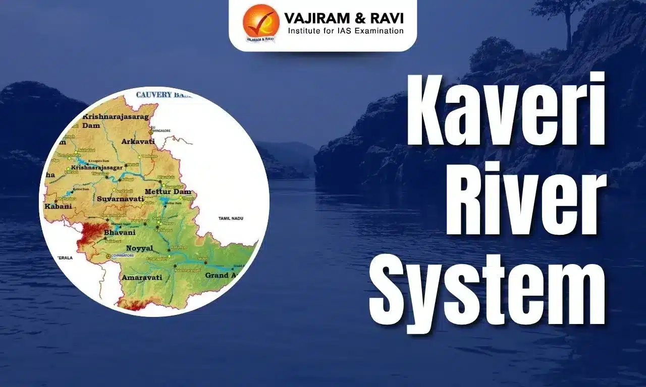
The Kaveri is a major east-flowing peninsular river, originating at Talakaveri in the Brahmagiri range of the Western Ghats in Karnataka and flowing for about 800 km before entering the Bay of Bengal. Its basin extends across Karnataka, Tamil Nadu, Kerala and Puducherry, covering about 85,167 sq km according to the CWC’s GIS-based reassessment.
The Kaveri River System supports extensive agriculture, irrigation, drinking-water supply, hydropower, settlements and ecosystems across southern India. The Kaveri River System is also significant for interstate water governance, with the long-standing sharing dispute involving Karnataka, Tamil Nadu, Kerala and Puducherry. Sustainable management therefore requires integrated basin planning, efficient water use, ecological-flow protection and cooperative interstate water management.
Kaveri River System Origin
The Kaveri River System, also known as the ‘Ganga of the South', originates at Talakaveri in the Brahmagiri Hills of Karnataka.
- Kaveri flows for about 800 km through Karnataka and Tamil Nadu before draining into the Bay of Bengal.
- Receiving rainfall from both the Southwest and Northeast Monsoons, the Kaveri has relatively sustained flows, though its discharge varies seasonally.
- The river supports irrigation, hydropower, drinking-water supply, agriculture and ecosystems across southern India.
Kaveri River System Basin
The Kaveri River Basin is an important Peninsular river system extending across southern India and supporting extensive agriculture, settlements and economic activities.
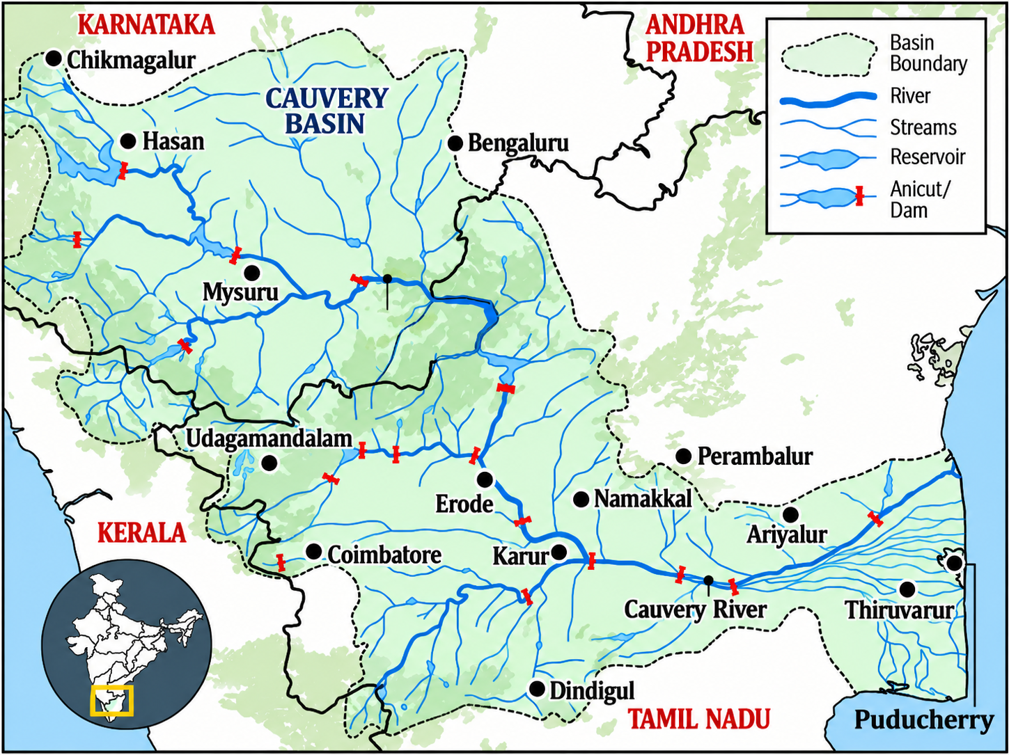
- The basin extends across Karnataka, Tamil Nadu, Kerala and Puducherry and comprises the Western Ghats, Mysore Plateau and Kaveri Delta.
- The delta is highly fertile and supports intensive agriculture. The basin has diverse soils, including red, black, lateritic, alluvial, forest and mixed soils.
- The Kaveri River System Basin area is 85,626 square kilometres according to modern, high-resolution GIS calculations and the updated India-WRIS Database.
- It extends between approximately 75°27′E and 79°54′E longitude and 10°09′N and 13°30′N latitude. The basin is bounded by:
- Western Ghats in the west.
- Eastern Ghats towards the east and south.
- Ridges separating it from the neighbouring Krishna and Pennar basins in the north and south.


Kaveri River System Tributaries
The Kaveri River System is divided into two parts; the first part is called the right-bank tributaries of Kaveri, and the second part is called the left-bank tributaries of Kaveri.
| Kaveri River System Tributaries | |
| River | Description |
|
Harangi River |
|
|
Hemavati River |
|
|
Lakshmana Tirtha River |
|
|
Amaravathi River |
|
|
Bhavani River |
|
|
Kabini River |
|
|
Noyyal River |
|
|
Arkavathi River |
|
|
Shimsha River |
|
Kaveri River System Major Dams
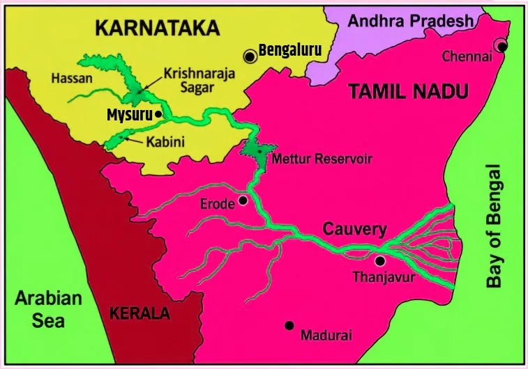
Major dams and reservoirs on the Kaveri system regulate water for irrigation, drinking water, hydropower and other requirements across the basin.
|
Major Dam/Structure |
State |
River |
Major Significance |
|
Harangi Dam |
Karnataka |
Harangi |
Irrigation and water regulation in the upper Kaveri system |
|
Hemavathy Dam |
Karnataka |
Hemavati |
Irrigation and water storage |
|
Krishnarajasagar (KRS) Dam |
Karnataka |
Kaveri |
Major irrigation and water-storage project |
|
Kabini Dam |
Karnataka |
Kabini |
Water storage and irrigation |
|
Mettur Dam |
Tamil Nadu |
Kaveri |
Major irrigation and water-storage project |
|
Bhavanisagar Dam |
Tamil Nadu |
Bhavani |
Irrigation and water management |
|
Grand Anicut (Kallanai) |
Tamil Nadu |
Kaveri |
Historic diversion structure supporting delta irrigation |
Kaveri River System Major Waterfalls
Major waterfalls of the Kaveri River occur where the river crosses rocky terrain and steep gradients, creating prominent cascades along its course through Karnataka and Tamil Nadu.
|
Waterfall |
Location |
Key Feature |
|
Chunchanakatte Falls |
Mysuru region, Karnataka |
Important waterfall on the Kaveri, located upstream of Krishnarajasagar Dam; the Government of Karnataka records a drop of about 20 m. |
|
Shivanasamudra Falls |
Karnataka |
Major twin waterfall where the Kaveri divides into Gaganachukki and Bharachukki. |
|
Gaganachukki Falls |
Shivanasamudra, Karnataka |
Western branch of Shivanasamudra, with a reported height of about 90 m. |
|
Bharachukki Falls |
Shivanasamudra, Karnataka |
Eastern branch of Shivanasamudra, with a reported height of about 69 m. |
|
Hogenakkal Falls |
Tamil Nadu, near the Karnataka–Tamil Nadu border |
Major Kaveri waterfall, where the river descends through rocky terrain before continuing towards the Mettur region. |
Kaveri River System Importance
The importance of the Kaveri River extends beyond drainage because its waters support agriculture, irrigation, settlements, industries, hydropower and ecosystems across southern India.
- Agriculture: The river supports extensive irrigated agriculture, particularly in Karnataka and Tamil Nadu.
- Irrigation: Dams, reservoirs, anicuts and canals distribute Kaveri water across agricultural areas.
- Hydropower: The river's elevation differences and waterfalls have supported hydropower development, particularly at Shivanasamudra.
- Drinking water: The basin supports major urban and rural water requirements.
- Industrial development: Industries such as paper, sugar, chemicals and textiles depend on water resources within the basin.
- Delta agriculture: The lower Kaveri system sustains the fertile deltaic agricultural region of Tamil Nadu.
- Tourism: Shivanasamudra and Hogenakkal are important tourist attractions associated with the river.
- Cultural importance: The Kaveri has long-standing religious and cultural significance in southern India.
Kaveri River Drainage Basin in Different States
Kaveri River drainage basin covers Karnataka, Tamil Nadu, Kerala and Puducherry, with the largest portion of the basin lying in Tamil Nadu.
- Tamil Nadu: Tamil Nadu contains about 47,084 sq km of the Kaveri basin, accounting for approximately 55.28% of the total basin area.
- It has the largest share of the Kaveri drainage basin.
- The main river flows for around 416 km through Tamil Nadu and forms an extensive lower basin and deltaic system.
- Karnataka: Karnataka covers approximately 35,110 sq km, or about 41.24% of the total Kaveri basin.
- The Kaveri originates at Talakaveri in the Brahmagiri Hills of the Western Ghats in Karnataka.
- Around 320 km of the river's course lies within Karnataka. Major tributaries and important reservoirs of the upper Kaveri system are also located here.
- Kerala: Kerala accounts for approximately 2,776 sq km, representing about 3.26% of the Kaveri basin.
- The state's contribution is mainly through tributary and catchment areas forming part of the wider Kaveri drainage system rather than through the main Kaveri channel.
- Puducherry: Puducherry has the smallest share, with approximately 187 sq km, equivalent to about 0.22% of the total basin.
- The Kaveri drainage system extends into the Karaikal region, where distributaries of the lower Kaveri reach the coastal area.
- Total Kaveri Basin: According to the Central Water Commission's GIS-based reassessment, the Kaveri basin covers approximately 85,167 sq km, with a maximum length of about 560 km and a width of around 245 km.
- Earlier CWC assessments placed the basin area at about 81,155 sq km.
Kaveri River Dispute
The Kaveri River dispute is a long-standing inter-state water-sharing conflict involving Karnataka, Tamil Nadu, Kerala and Puducherry over the equitable use of Kaveri waters.
- Origin of the dispute: The dispute primarily concerns the sharing, release and utilisation of Kaveri waters between the upper-riparian state of Karnataka and the lower-riparian states, particularly Tamil Nadu, along with Kerala and Puducherry.
- Historical agreements: The dispute has roots in the 1892 and 1924 agreements between the erstwhile Madras Presidency and Mysore State. Differences later emerged over the construction and utilisation of irrigation projects and the distribution of river water.
- Cauvery Water Disputes Tribunal: The Cauvery Water Disputes Tribunal (CWDT) was constituted by the Central Government in 1990 under the Inter-State River Water Disputes Act, 1956, to adjudicate the dispute among Karnataka, Tamil Nadu, Kerala and Puducherry.
- Tribunal Award, 2007: The CWDT submitted its final report and award on 5 February 2007, determining the allocation of Kaveri waters among the basin states and Puducherry.
- Supreme Court intervention: The Supreme Court delivered its final judgement on 16 February 2018, modifying certain aspects of the Tribunal's award.
- It emphasised that inter-state river waters constitute a national asset and that no state can claim exclusive ownership over such waters.
- 2018 allocation: The Supreme Court made an adjustment in the allocation and provided additional water to Karnataka, while reducing Tamil Nadu's share correspondingly, among other directions.
- Cauvery Water Management Authority: Following the Supreme Court's directions, the Union Government framed the Cauvery Water Management Scheme in 2018 to implement the Tribunal's award as modified by the Court.
- Core issue: The dispute becomes particularly acute during weak monsoon years, when available reservoir storage falls, and the states differ over the quantity and timing of water releases.
Kaveri River System Challenges
Challenges facing the Kaveri River include increasing pressure on water resources, competing demands, variable rainfall and the need to maintain adequate downstream flows.
- Seasonal rainfall dependence: Variability in monsoon rainfall can influence reservoir inflows and river discharge.
- Water demand: Growing agricultural, urban and industrial requirements increase pressure on available water.
- Interstate water management: Different demands across basin states require coordinated water management.
- Reservoir dependence: Large-scale irrigation depends substantially on regulated releases from reservoirs.
- Pollution: Urbanisation and industrial activity can place pressure on river water quality.
- Ecological flows: Maintaining sufficient downstream flows is important for aquatic ecosystems and the delta.
Kaveri River and Climate Change
Climate change can influence the Kaveri system through changes in rainfall patterns, extreme precipitation, drought frequency, temperature and evaporation.
- Changing monsoon: Variations in rainfall timing and intensity can alter seasonal river flows.
- Extreme rainfall: Intense rainfall can increase flood risks and sediment movement.
- Dry periods: Longer periods of low rainfall can reduce reservoir inflows and water availability.
- Higher temperatures: Increased evaporation can add to water losses from reservoirs and catchments.
- Agricultural stress: Changes in river availability can affect irrigation-dependent farming.
- Ecosystem impacts: Altered flow regimes can affect wetlands, aquatic habitats and the Kaveri delta.
Kaveri River System Way Forward
Sustainable management of the Kaveri requires integrated basin planning that balances irrigation, drinking-water needs, ecological requirements and long-term climate resilience.
- Promote Basin-Level Integrated Water-Resource Management: Adopt a river-basin approach that considers the entire hydrological system rather than individual state or project boundaries, enabling coordinated planning of surface water, groundwater, irrigation and urban demand.
- Improve Irrigation Efficiency: Promote drip and sprinkler irrigation, micro-irrigation, water-efficient crops and improved canal management to reduce water losses and increase agricultural productivity per unit of water.
- Strengthen Rainwater Harvesting and Groundwater Recharge: Expand farm ponds, check dams, recharge structures and watershed development to enhance groundwater availability, moderate runoff and provide a buffer during periods of low river flows.
- Protect Catchments, Wetlands and Riparian Ecosystems: Restore degraded catchments, wetlands and riparian vegetation to improve infiltration, reduce soil erosion and sedimentation, maintain biodiversity and strengthen the ecological health of the river system.
- Maintain Environmental Flows: Ensure that reservoir operations and water diversions maintain adequate downstream flows, particularly during ecologically sensitive periods, to sustain aquatic ecosystems, wetlands, fisheries and the Kaveri delta.
- Strengthen Pollution Control and Wastewater Treatment: Improve sewage treatment, industrial effluent management and reuse of treated wastewater in urban and industrial areas to reduce pollution loads entering the river and its tributaries.
- Use Real-Time Hydrological Data for Reservoir Management: Develop real-time monitoring of rainfall, reservoir storage, river discharge and water demand to support transparent and scientifically informed reservoir operations, particularly during drought and distress years.
- Strengthen Interstate Cooperation and Institutions: Enhance coordination among Kaveri basin states, the Cauvery Water Management Authority (CWMA) and other institutions through transparent data-sharing, joint assessment and predictable mechanisms for managing normal as well as distress years.
- Promote Climate-Resilient Agriculture: Encourage drought-resistant and less water-intensive crops, improved irrigation practices, soil-moisture conservation and climate-smart farming in water-stressed regions to reduce agricultural dependence on uncertain river flows.
- Adopt Demand-Side Water Management: Shift from a supply-oriented approach towards water budgeting, efficient urban consumption, crop planning and reuse of treated wastewater, reducing pressure on the basin's finite water resources.
- Strengthen Delta and Coastal Resilience: Protect the Kaveri delta through sustainable water releases, wetland conservation, groundwater management and measures against salinity intrusion, ensuring the long-term sustainability of agriculture and coastal ecosystems.

 Last updated on Oct, 2026
→ UPSC 2027 Notification will be released on 13 January 2027 at upsconline.nic.in.
→ Check Nobel Prize 2026 Winners List here.
→ Download PIB PRiSM Monthly Magazine 2026 here.
→ Check UPSC Monthly Current Affairs Magazine The Recitals here.
→ Check out the latest UPSC Syllabus here.
→ Download UPSC Model Answers for Mains 2026
→ UPSC Mains Question Paper 2026 is out now for Essay & GS Paper 1, 2, 3 & 4.
→ UPSC Calendar 2027 has been released.
→ Enroll in Vajiram & Ravi’s UPSC Mains Test Series 2027 for structured answer writing practice, expert evaluation, and exam-oriented feedback.
→ Join Vajiram & Ravi’s UPSC Mentorship Program 2027 for personalized guidance, strategy planning, and one-to-one support from experienced mentors.
→ Go through the UPSC Mains Previous Year Papers to enhance your preparation.
→ UPSC has released UPSC Toppers List 2025 with the Civil Services final result on its official website.
→ Also check Best UPSC Coaching in India
Kaveri River System FAQs
Q1. What is the Kaveri river system?+
Q2. What is the river system of India made up of?+
Q3. Which states are drained by river Kaveri?+
Q4. Which is the longest tributary of Kaveri?+
Q5. What is the real name of Kaveri River?+
Tags: Kaveri River System quest UPSC Geography Notes