The Western Ghats are an ancient mountain system running parallel to India’s western coast, extending for about 1,600 km across Gujarat, Maharashtra, Goa, Karnataka, Kerala and Tamil Nadu. They significantly influence the Indian monsoon by intercepting southwest monsoon winds and shaping regional rainfall and drainage. The range is internationally recognised as one of the world’s major biodiversity hotspots, supporting thousands of plant species and numerous endemic and threatened species. Its forests, rivers, mountains and ecosystems provide important ecological services, including water security, climate regulation and habitat protection.
The Western Ghats also hold global geological and evolutionary significance and contain several protected areas and UNESCO World Heritage components. However, habitat loss, infrastructure, tourism, quarrying, and climate change pose growing challenges.
Western Ghats Geological Formation
The Western Ghats are an ancient geomorphic feature whose evolution is closely associated with the breakup of the Gondwana supercontinent, subsequent rifting of the Indian landmass, uplift, faulting, volcanism in parts of the region and prolonged erosion.
- Gondwana connection: The Indian landmass was once part of the ancient Gondwana supercontinent.
- Rifting and continental breakup: During the breakup of Gondwana, India separated from other continental fragments, accompanied by major tectonic and volcanic processes along its western margin.
- Formation of the western escarpment: The Ghats developed as a major escarpment along the western margin of the Peninsular Plateau through a combination of uplift, faulting, rifting and subsequent erosion.
- Deccan Volcanism: In the northern and central Western Ghats, extensive Deccan Traps basaltic volcanism around the end-Cretaceous period contributed to the geological character of the region.
- Long-term erosion: Weathering, river erosion, and differential erosion progressively shaped the present-day relief, steep western escarpments, valleys, and plateaus.
- Biological evolution: Long geological isolation, varied elevation, climate, and habitat diversity promoted species diversification and high endemism.
Western Ghats Geography and Location
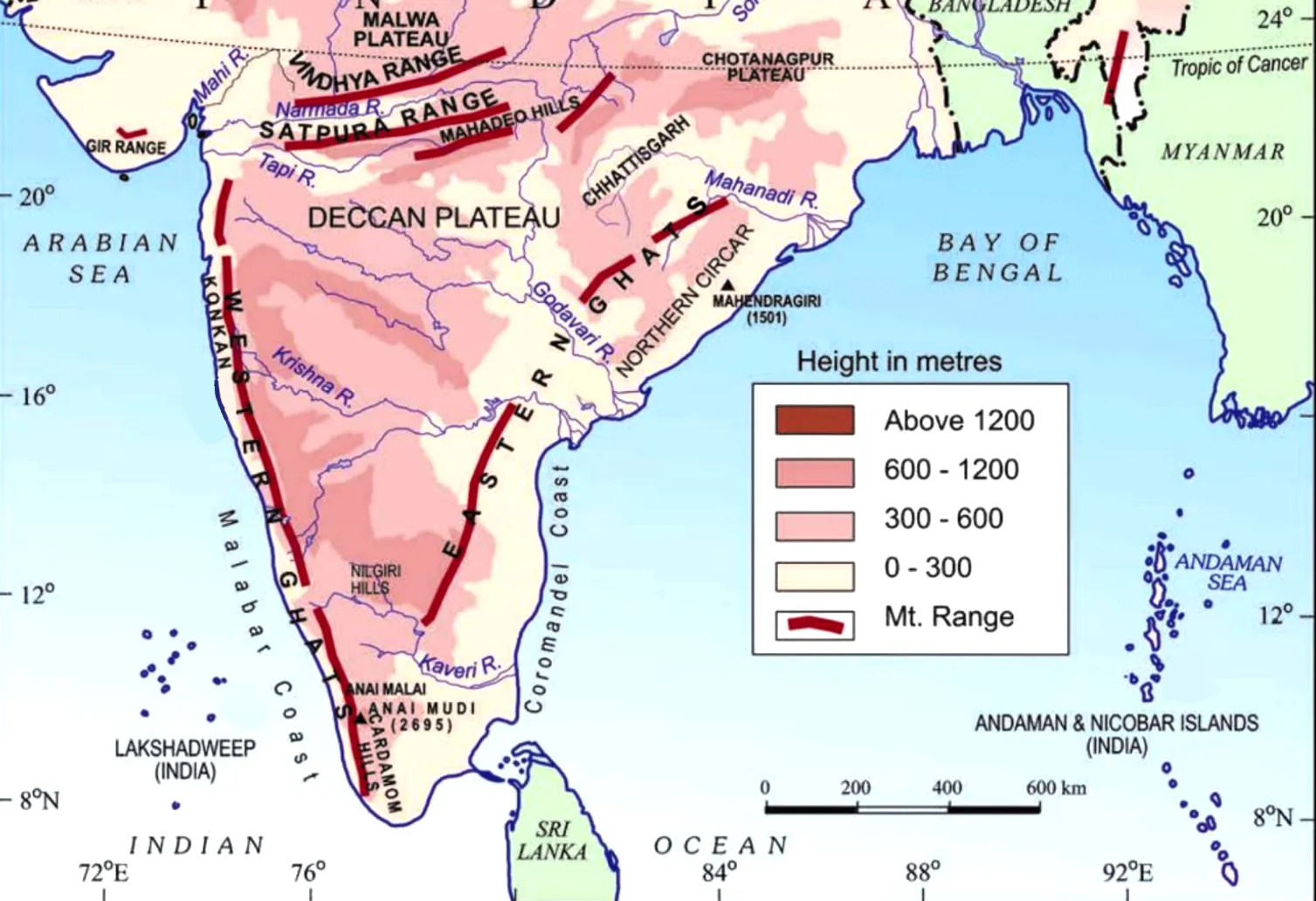
The geography of the Ghats is characterised by a north-south mountain chain, steep western slopes, varied elevations and numerous valleys and gaps across Peninsular India.
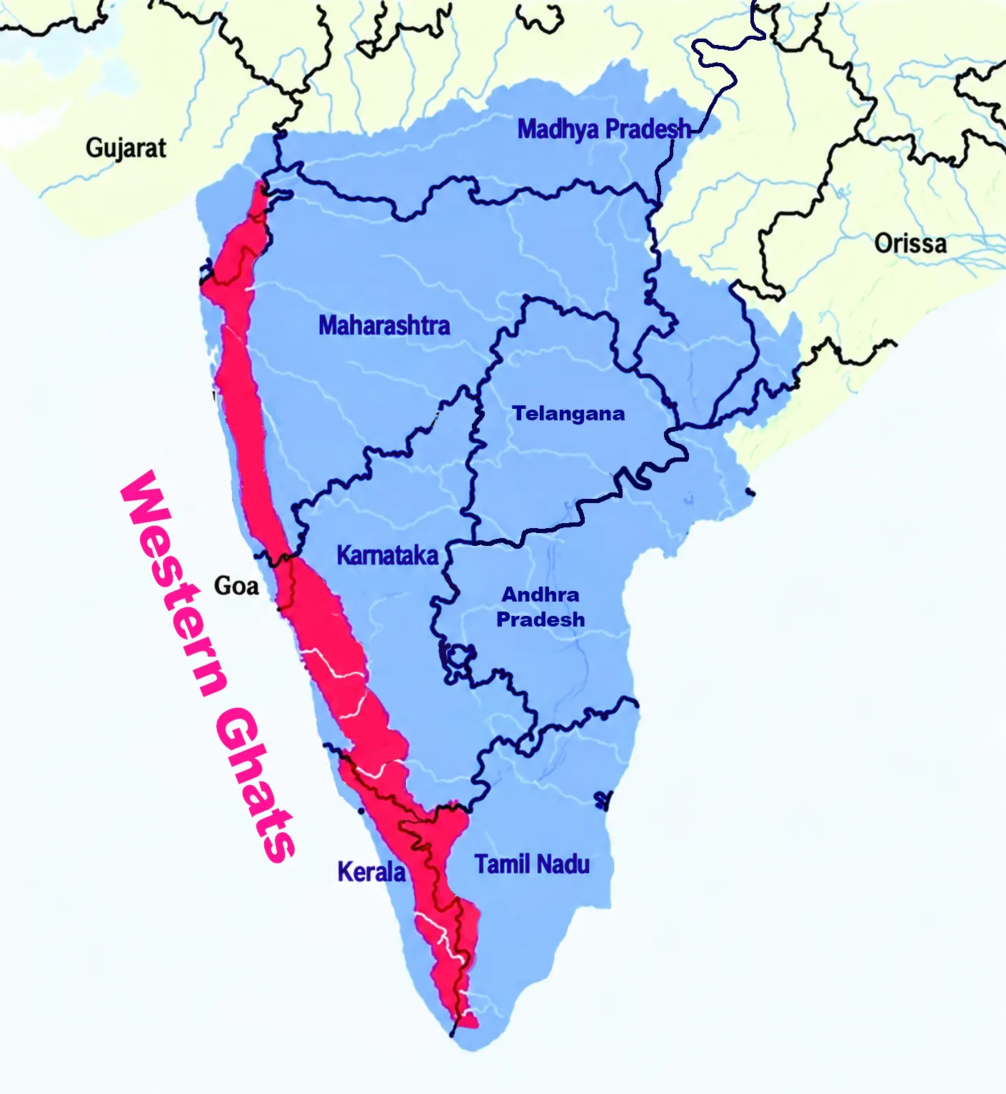
- The Western Ghats extend through:
- Gujarat
- Maharashtra
- Goa
- Karnataka
- Kerala
- Tamil Nadu
- The range runs parallel to the Arabian Sea coast and forms an important transition between the western coastal belt and the interior Deccan Plateau. Important Geographical Features
- Length: Approximately 1,600 km.
- Location: Generally 30–50 km inland from the western coast.
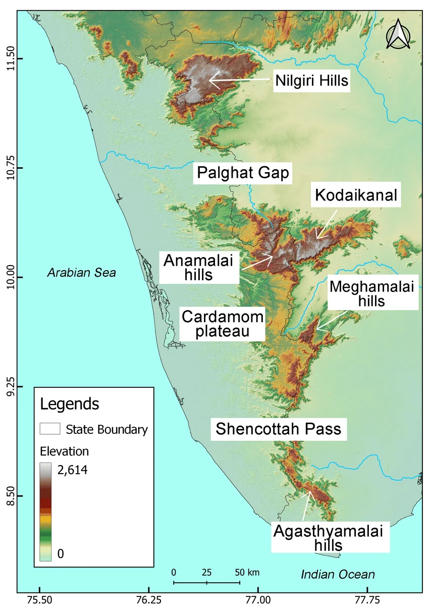
- Palghat Gap: A major break in the mountain chain.
- Average elevation: The Ghats are generally higher and more continuous than the Eastern Ghats.
- Slope: The western side is generally steeper, while the eastern side connects more gradually with the Deccan Plateau.
- Watershed role: The range forms an important watershed for several major Peninsular rivers.


Western Ghats Major Mountain Ranges and Hills
The Western Ghats consist of several interconnected mountain ranges and highland groups that vary considerably in elevation, geology, vegetation, and ecological characteristics.
- Sahyadri Range: The Sahyadri forms an important northern and central section of the Western Ghats, particularly across Maharashtra and adjoining regions.
- Nilgiri Hills: The Nilgiri Hills occur near the meeting zone of the Western and Eastern Ghats and contain important high-elevation forests and grasslands.
- Anaimalai Hills: The Anaimalai Hills form a high mountain region in Kerala and Tamil Nadu and contain Anamudi, the highest peak of the Western Ghats.
- Cardamom Hills: The Cardamom Hills form an important highland region of the southern Western Ghats, particularly in Kerala, with extensions towards Tamil Nadu and are characterised by high rainfall, forests and important plantation landscapes.
- Agasthyamalai Hills: The Agasthyamalai Hills lie in the southern Western Ghats and are recognised for their high biodiversity, endemic species and forest ecosystems.
- Kudremukh Hills: The Kudremukh Hills in Karnataka form an important highland landscape characterised by forests, grasslands, steep slopes and rich biodiversity.
Highest Peaks of Western Ghats
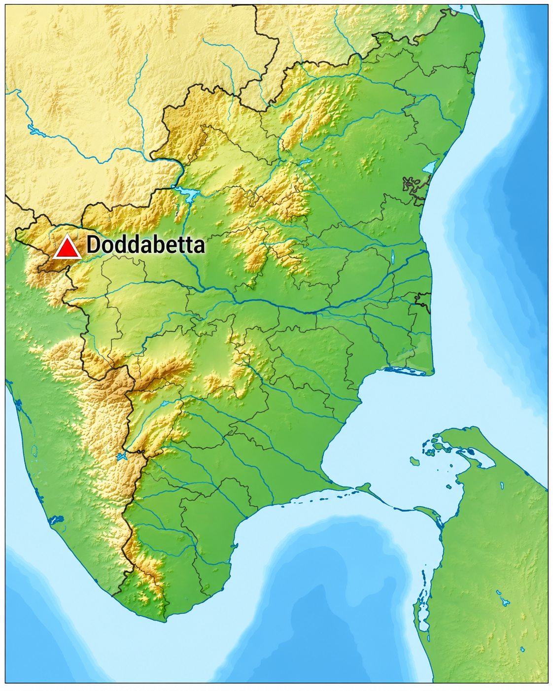
The major peaks of the Western Ghats represent the high-elevation landscapes of the Peninsular mountain system. Anamudi, at about 2,695 m, is the highest peak of the Western Ghats and the highest point of the Peninsular Plateau.
| Peak | Elevation | Location |
|
Anamudi |
2,695 m |
Kerala |
|
Doddabetta |
2,637 m |
Tamil Nadu |
|
Meesapulimala |
~2,640 m |
Kerala |
|
Mukurthi Peak |
~2,556 m |
Tamil Nadu |
|
Kudremukh |
~1,894 m |
Karnataka |
|
Agasthyamalai |
~1,868 m |
Kerala–Tamil Nadu |
Western Ghats Rivers and Drainage
The Western Ghats function as a major watershed of Peninsular India, giving rise to numerous rivers that flow towards both the Arabian Sea and the Bay of Bengal.
- Major East-Flowing Rivers:
- Godavari: It rises near Trimbakeshwar in Maharashtra and flows eastwards towards the Bay of Bengal.
- Krishna: Originates near Mahabaleshwar and flows eastward across the Deccan Plateau.
- Kaveri: Rises at Talakaveri in Karnataka and flows towards the Bay of Bengal.
- Tungabhadra: Formed by the Tunga and Bhadra rivers and ultimately joins the Krishna system.
- Bhima: An important tributary of the Krishna.
- Major West-Flowing Rivers:
- Periyar: An important river of Kerala draining towards the Arabian Sea.
- Sharavathi: A major Karnataka river flowing westward and associated with Jog Falls.
- Netravati: A significant west-flowing river of Karnataka.
- Mandovi: An important river system of Goa originating in the Western Ghats.
- Most major peninsular rivers originating on/near the Ghats flow eastward towards the Bay of Bengal, whereas numerous shorter rivers flow westward towards the Arabian Sea.
Western Ghats Biodiversity
The biodiversity of the Western Ghats is exceptionally rich, with high levels of species diversity and endemism, making the region one of the world's major biodiversity hotspots.
- The Western Ghats–Sri Lanka region is recognised as one of the world's biodiversity hotspots, while UNESCO describes the Western Ghats as one of the world's eight ‘hottest hotspots’ of biological diversity.
- The region contains tropical evergreen forests, montane grasslands, Shola forests and specialised wetland habitats. UNESCO records approximately:
- 4,000–5,000 plant species
- Nearly 650 tree species
- 352 tree species endemic to the Western Ghats
- Up to 179 amphibian species, around 65% endemic
- 157 reptile species, around 62% endemic
- 219 fish species, around 53% endemic
- The Western Ghats also contain at least 325 globally threatened species recorded in the UNESCO World Heritage property.
Western Ghats Important Flora and Fauna
The Western Ghats support exceptional biodiversity, including several endemic, threatened, and iconic species, along with diverse forest, grassland, wetland, and riverine ecosystems. The Western Ghats provide habitat to several important mammals and other wildlife, including
- Lion-tailed macaque: An endemic primate associated with the evergreen forests of the Western Ghats.
- Nilgiri tahr: An endemic mountain ungulate found mainly in high-altitude grassland and shola habitats.
- Nilgiri langur: A primate closely associated with the forests of the Western Ghats.
- Asian elephant: Found across several forest landscapes and wildlife corridors.
- Tiger: Protected in several tiger reserves within the Western Ghats landscape.
- Gaur: A major large herbivore occurring in forest ecosystems.
- Grizzled giant squirrel: Found in parts of the Western Ghats and associated forest habitats.
- Endemic amphibians and reptiles: The region supports numerous species with restricted geographical ranges.
Western Ghats Important Ecosystems
- Tropical evergreen forests – Dense, species-rich forests supporting numerous endemic plants and animals.
- Shola forests – Montane forests occurring mainly in higher elevations of the southern Western Ghats.
- Montane grasslands – High-altitude grasslands closely associated with shola ecosystems.
- Myristica swamps – Important wetland forest ecosystems with specialised vegetation.
- Seasonal wildflower meadows – Support diverse flowering plants and associated pollinators.
- Riverine and wetland ecosystems – Provide habitats for aquatic species and support freshwater biodiversity.
Western Ghats Important National Parks and Tiger Reserves
Several protected areas in the Western Ghats conserve important habitats and wildlife. Important examples include
| Protected Area | State | Major Wildlife/Significance |
|
Silent Valley National Park |
Kerala |
Evergreen forests, lion-tailed macaque and rich endemic biodiversity |
|
Eravikulam National Park |
Kerala |
Nilgiri tahr, montane grasslands and shola ecosystems |
|
Periyar National Park and Tiger Reserve |
Kerala |
Tiger, Asian elephant, gaur and diverse forest ecosystems |
|
Bandipur Tiger Reserve |
Karnataka |
Tiger, elephant, gaur and major wildlife corridors |
|
Nagarhole Tiger Reserve |
Karnataka |
Tiger, elephant, gaur and moist deciduous forests |
|
Wayanad Wildlife Sanctuary |
Kerala |
Elephants, tigers and connectivity with neighbouring forest landscapes |
|
Anamalai Tiger Reserve |
Tamil Nadu |
Tiger, elephant, lion-tailed macaque and diverse Western Ghats habitats |
|
Kalakkad–Mundanthurai Tiger Reserve |
Tamil Nadu |
Evergreen forests, rivers and high biodiversity |
|
Mudumalai Tiger Reserve |
Tamil Nadu |
Tiger, elephant, gaur and Nilgiri landscape biodiversity |
|
Bhadra Tiger Reserve |
Karnataka |
Tiger, elephant, gaur and forest ecosystems |
|
Kali Tiger Reserve (formerly Dandeli–Anshi Tiger Reserve) |
Karnataka |
Western Ghats forests, hornbills and large mammals |
Western Ghats as a UNESCO World Heritage Site
The Western Ghats were inscribed on the UNESCO World Heritage List in 2012 under Criteria (ix) and (x) for their ecological and evolutionary significance.
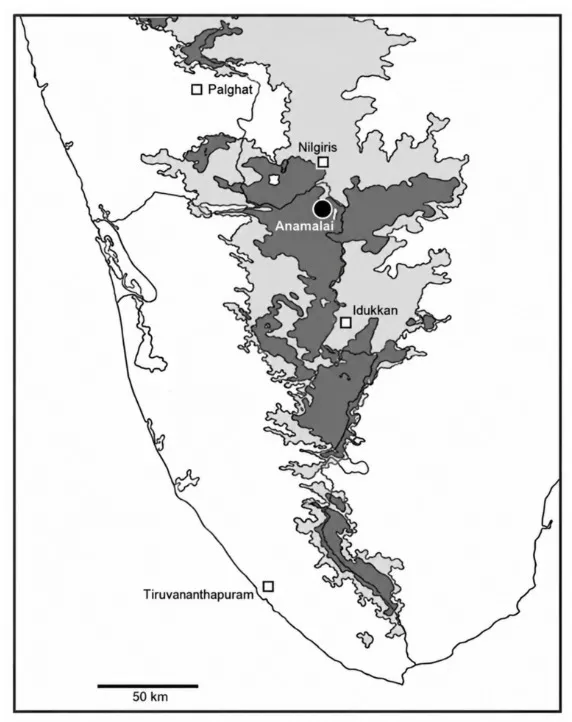
- The UNESCO property is a serial site comprising 39 component parts grouped into seven sub-clusters. This arrangement reflects the considerable variation in species composition and ecological characteristics along the approximately 1,600-km mountain chain. The seven sub-clusters include landscapes associated with:
- Agasthyamalai
- Periyar
- Anamalai
- Nilgiri
- Talacauvery
- Kudremukh
- Sahyadri
Western Ghats Major Passes and Gaps
The Western Ghats form a relatively continuous mountain barrier, but several important natural gaps and passes provide routes between the western coastal plains and the interior Deccan Plateau. These gaps are important for transportation, trade, settlement, climate and regional connectivity.
| Pass/Gap | Location | Connects | Geographical Significance |
|
Thal Ghat (Kasara Ghat) |
Maharashtra |
Mumbai–Nashik |
Important road and railway corridor through the northern Western Ghats; provides a route from the Konkan coast towards the Deccan interior. |
|
Bhor Ghat |
Maharashtra |
Mumbai–Pune |
Major transport corridor across the Sahyadris, historically important for railway and road connectivity between Mumbai and the Deccan Plateau. |
|
Palakkad Gap (Palghat Gap) |
Kerala– Tamil Nadu |
Palakkad – Coimbatore |
A broad natural gap between the Nilgiri Hills and Anaimalai Hills; an important transport corridor and a major passage for air masses between the western coast and the interior of Tamil Nadu. |
|
Shencottah (Senkottai) Gap |
Kerala– Tamil Nadu |
Southern Kerala–southern Tamil Nadu |
Important natural break in the southern Western Ghats, providing road and railway connectivity between the two states. |
Western Ghats Significance
The significance of the Western Ghats extends beyond biodiversity because the mountains influence India's climate, water resources, agriculture, forests, livelihoods and cultural landscapes.
- Biodiversity Conservation: The Ghats contain exceptional species diversity and endemism and provide habitats for numerous threatened species.
- Water Security: The mountains act as a major watershed and provide catchments for important Peninsular rivers.
- Climate and Monsoon: The mountain barrier influences the southwest monsoon and contributes to regional rainfall patterns.
- Agriculture: Western Ghats landscapes support plantation crops, spices, horticulture and agriculture in surrounding regions.
- Hydropower: The steep terrain and perennial or seasonal rivers provide important sites for hydropower generation.
- Forest Resources: The forests provide ecosystem services including soil protection, water regulation, carbon storage and habitat support.
- Tourism: Mountain landscapes, waterfalls, forests, wildlife reserves and hill stations support tourism and associated livelihoods.
- Geological and Cultural Value: UNESCO recognises the Western Ghats for their geological, cultural and aesthetic values, in addition to their ecological importance.
Western Ghats Major Threats
The major threats to the Western Ghats arise from habitat fragmentation, infrastructure expansion, resource extraction, pollution, climate variability and increasing pressure from human activities.
- Deforestation: Conversion of forests for agriculture, plantations, settlements and infrastructure can reduce habitat quality and connectivity.
- Habitat Fragmentation: Roads, railways, transmission lines and other infrastructure can divide previously connected habitats.
- Mining and Quarrying: Extraction activities can alter slopes, disturb habitats and affect local drainage systems.
- Hydropower and Infrastructure: Large infrastructure projects can modify river systems, forests and mountain slopes when environmental safeguards are inadequate.
- Tourism Pressure: Unplanned tourism can increase waste, traffic, water demand and construction pressure in ecologically sensitive locations.
- Climate Change: Changing temperature and rainfall patterns can affect forests, endemic species, rivers, agriculture and mountain ecosystems.
- Human-Wildlife Conflict: Habitat loss and fragmentation can bring wildlife increasingly into contact with agricultural and human settlements.
- Invasive Species: Invasive plants can alter native habitats and affect ecological processes.
- Landslides and Extreme Rainfall: Heavy rainfall combined with steep terrain, geological conditions and land-use changes can increase landslide vulnerability.
Western Ghats Committees for Conservation
Several expert groups and institutional mechanisms have contributed to debates over conservation, ecological sensitivity and sustainable development in the Western Ghats.
- Western Ghats Ecology Expert Panel — Gadgil Committee: The Western Ghats Ecology Expert Panel (WGEEP), chaired by Prof. Madhav Gadgil, was constituted to examine the ecological sensitivity of the Western Ghats and recommend measures for its conservation and sustainable management.
- Its approach emphasised ecologically sensitive areas, decentralised governance, biodiversity conservation and regulation of environmentally damaging activities.
- The panel evaluated the region at the taluka level, classifying all 142 talukas into Ecologically Sensitive Zones (ESZ) 1, 2, and 3 based on ecological fragility.
- High Level Working Group — Kasturirangan Committee: The High Level Working Group (HLWG), chaired by Dr K. Kasturirangan, was subsequently constituted to examine the conservation and development issues of the Western Ghats. The group used geospatial analysis to identify ecologically sensitive areas.
- The committee sought to balance environmental protection with the developmental and livelihood requirements of local populations.
- Instead of treating the entire range uniformly, the committee used remote sensing technology to separate the Ghats into a Cultural Landscape (59% human settlements, agriculture) and a Natural Landscape (41% high biodiversity).
- It recommended bringing 37% (about 60,000 sq km) under the strict ESA legal umbrella.
- Western Ghats Natural Heritage Management Committee: UNESCO records the Western Ghats Natural Heritage Management Committee (WGNHMC) as a coordination mechanism under the Ministry of Environment and Forests for integrating management across the World Heritage components.
- The UNESCO framework also notes that the 39 component sites are managed through specific management or working plans and that local community participation is supported through Village Ecodevelopment Committees.
Western Ghats Conservation Measures
- Conservation of the Western Ghats is supported through protected areas, forest laws, wildlife legislation, World Heritage management and ecological-sensitivity measures.
- The UNESCO property is covered by different protection regimes, including Tiger Reserves, National Parks, Wildlife Sanctuaries and Reserved Forests. UNESCO also notes the relevance of the Wildlife (Protection) Act, 1972, the Indian Forest Act, 1927, and the Van (Sanrakshan Evam Samvardhan) Adhiniyam, 1980, for the protection of the component areas.
- The Ministry of Environment, Forest and Climate Change continues to maintain a framework of Western Ghats Ecologically Sensitive Area (ESA) notifications and draft notifications. Its current website lists a 27 July 2026 draft notification concerning the Western Ghats ESA, demonstrating that the regulatory process remains active.
- Total proposed ESA: About 56,825.7 sq km of the Western Ghats is proposed to be declared ecologically sensitive.
- States covered: The proposed ESA extends across Gujarat, Maharashtra, Goa, Karnataka, Tamil Nadu and Kerala.
- State-wise proposed area: Gujarat – 449 sq km; Maharashtra – 17,340 sq km; Goa – 1,461 sq km; Karnataka – 20,668 sq km; Tamil Nadu – 6,914 sq km; Kerala – 9,993.7 sq km.
- Legal basis: The draft is proposed under Section 3 of the Environment (Protection) Act 1986, read with the Environment (Protection) Rules, 1986.
Western Ghats and Eastern Ghats Difference
The Eastern and Western Ghats form the major mountain systems of Peninsular India, but they differ considerably in their continuity, elevation, rainfall, drainage, biodiversity and geographical characteristics.
| Basis | Western Ghats | Eastern Ghats |
|
Location |
Run along the western margin of the Peninsular Plateau, broadly parallel to the Arabian Sea coast. |
Extend along the eastern margin of the Peninsular Plateau, broadly parallel to the Bay of Bengal coast. |
|
Extent |
Stretches for about 1,600 km from the western part of Gujarat towards southern Tamil Nadu. |
Extends discontinuously from Odisha through Andhra Pradesh and Telangana to Tamil Nadu. |
|
Continuity |
Relatively continuous, although interrupted by important gaps such as the Palghat Gap. |
Discontinuous and fragmented, with several river valleys cutting across the hills. |
|
Elevation |
Generally higher and more prominent than the Eastern Ghats. |
Generally lower and more eroded than the Western Ghats. |
|
Highest Peak |
Anamudi (2,695 m) in Kerala is the highest peak. |
Jindhagada Peak in Andhra Pradesh is among the highest points of the Eastern Ghats. |
|
Major Hills/Ranges |
Sahyadri, Nilgiri, Anaimalai, Cardamom and Agasthyamalai ranges. |
Nallamala, Palkonda, Velikonda, Javadi and Mahendragiri hills. |
|
Rainfall |
Receives heavy rainfall from the southwest monsoon. |
Generally receives less southwest monsoon rainfall; southeastern sections are also influenced by the northeast monsoon. |
|
Monsoon Role |
Acts as a major barrier to southwest monsoon winds and causes orographic rainfall. |
Its discontinuous nature makes it a less effective barrier to monsoon winds. |
|
Drainage |
Gives rise to several important rivers, including the Godavari, Krishna and Kaveri, while numerous short rivers flow westward. |
Major east-flowing rivers such as the Mahanadi, Godavari, Krishna and Kaveri cut through the range. |
|
Biodiversity |
One of the world's major biodiversity hotspots, with exceptionally high levels of endemism. |
Supports significant forests and biodiversity, but generally has lower levels of endemism than the Western Ghats. |
|
Vegetation |
Tropical evergreen forests, semi-evergreen forests, shola forests and montane grasslands are prominent. |
Deciduous forests, scrub and dry forests are more widespread. |
|
Geographical Significance |
Strongly influences the climate, rainfall, river systems and biodiversity of Peninsular India. |
Acts as an important eastern highland system but is more deeply dissected by rivers and erosion. |
|
UNESCO Status |
Parts of the Western Ghats are recognised as a UNESCO World Heritage property because of their exceptional biodiversity and evolutionary significance. |
The Eastern Ghats do not have a comparable single UNESCO World Heritage designation for the entire mountain system |
Western Ghats Way Forward
The way forward for the Western Ghats requires an integrated approach that protects ecological connectivity while accommodating sustainable livelihoods and carefully planned development.
- Strengthen ecologically sensitive zoning: Identify and protect ecologically fragile landscapes using updated scientific data.
- Protect wildlife corridors: Maintain connectivity between fragmented forests and protected areas.
- Regulate mining and quarrying: Restrict environmentally damaging extraction in highly sensitive landscapes.
- Improve infrastructure planning: Incorporate cumulative ecological and geological assessments before major projects.
- Adopt river-basin planning: Manage rivers, catchments, forests and hydropower projects as interconnected systems.
- Promote sustainable agriculture: Encourage agroforestry, soil conservation and climate-resilient farming.
- Strengthen disaster preparedness: Improve landslide mapping, rainfall monitoring and early-warning systems.
- Promote responsible tourism: Ensure tourism remains compatible with local ecological carrying capacity.
- Restore degraded ecosystems: Rehabilitate fragmented forests, wetlands, grasslands and river catchments.
- Control invasive species: Strengthen monitoring and removal programmes for ecologically harmful invasive species.
- Empower local communities: Include forest-dependent communities in conservation decisions and livelihood planning.
- Improve Centre-State coordination: Strengthen coordination among governments, scientific institutions, protected-area authorities and local bodies.
Western Ghats UPSC PYQs
Q1. Consider the following statements: (UPSC Prelims 2017)
- In India, the Himalayas are spread over five States only.
- Western Ghats are spread over five States only.
- Pulicat Lake is spread over two States only.
Which of the statements given above is/are correct?
a) 1 and 2 only
b) 3 only
c) 2 and 3 only
d) 1 and 3 only
Ans: (b)
Q2. ‘Gadgil Committee Report’ and ‘Kasturirangan Committee Report’, sometimes seen in the news, are related to: (UPSC Prelims 2016)
a) Constitutional reforms
b) Ganga Action Plan
c) Linking of rivers
d) Protection of Western Ghats
Ans: (d)

 Last updated on Oct, 2026
→ UPSC 2027 Notification will be released on 13 January 2027 at upsconline.nic.in.
→ Check Nobel Prize 2026 Winners List here.
→ Download PIB PRiSM Monthly Magazine 2026 here.
→ Check UPSC Monthly Current Affairs Magazine The Recitals here.
→ Check out the latest UPSC Syllabus here.
→ Download UPSC Model Answers for Mains 2026
→ UPSC Mains Question Paper 2026 is out now for Essay & GS Paper 1, 2, 3 & 4.
→ UPSC Calendar 2027 has been released.
→ Enroll in Vajiram & Ravi’s UPSC Mains Test Series 2027 for structured answer writing practice, expert evaluation, and exam-oriented feedback.
→ Join Vajiram & Ravi’s UPSC Mentorship Program 2027 for personalized guidance, strategy planning, and one-to-one support from experienced mentors.
→ Go through the UPSC Mains Previous Year Papers to enhance your preparation.
→ UPSC has released UPSC Toppers List 2025 with the Civil Services final result on its official website.
→ Also check Best UPSC Coaching in India
Western Ghats FAQs
Q1. Where are the Western Ghats located?+
Q2. What is the difference between the Western Ghats and the Eastern Ghats?+
Q3. What is the other name of the Western Ghats?+
Q4. Which is the highest peak of the Western Ghats?+
Q5. Which committee is related to the Western Ghats?+
Tags: quest UPSC Geography Notes western ghats