
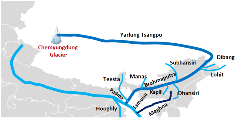
The Brahmaputra River is one of Asia’s major transboundary rivers, supporting agriculture, hydropower, biodiversity and livelihoods across northeastern India and neighbouring countries. Originating in the Tibetan Plateau near the Kailash range, it flows through Tibet as the Yarlung Tsangpo, enters Arunachal Pradesh as the Siang or Dihang, and becomes the Brahmaputra after receiving the Dibang and Lohit.
The Brahmaputra River flows westward through Assam before entering Bangladesh, where it is known as the Jamuna, eventually joining the Ganga system and draining into the Bay of Bengal. The river faces significant challenges, including monsoon floods, bank erosion, sedimentation and climate change. Sustainable management requires scientific monitoring, resilient infrastructure, ecosystem conservation and international cooperation.
Brahmaputra River Origin and Course
The Brahmaputra River is a major 2,900-kilometre-long transboundary river that flows through China, India, and Bangladesh.
- Origin: The Brahmaputra River originates in the Chemayungdung Glacier region on the Tibetan Plateau, near the Kailash range in southwestern Tibet. Its headwaters are sustained by snowmelt and glacial sources.
- The Brahmaputra River spans around 916 km in India
- Tibet (Yarlung Tsangpo): Known as the Yarlung Tsangpo or Tsangpo, the Brahmaputra River flows eastward across southern Tibet before bending around Namcha Barwa.
- Arunachal Pradesh (Siang/Dihang): After entering India, the Brahmaputra River is known as the Siang or Dihang and descends through the eastern Himalayas into Arunachal Pradesh.
- Assam (Brahmaputra): The river enters Assam and becomes known as the Brahmaputra after the Siang joins the Dibang and Lohit river systems near the eastern part of the state. It then flows southwest through the Assam Valley.
- Bangladesh (Jamuna): In Bangladesh, the Brahmaputra River is known as the Jamuna. It joins the Ganga system, and the combined waters ultimately drain into the Bay of Bengal.
- Course: Tibet (China) → Arunachal Pradesh → Assam → Bangladesh → Bay of Bengal.
Brahmaputra River Basin in India
The Indian part of the Brahmaputra River basin extends across six states, covering mountain catchments, forested hills and the extensive floodplains of Assam.
- According to the Government of Assam’s Water Resources Department, the basin’s drainage area in India is approximately 194,413 square kilometres. The state-wise distribution published by the department is given below.
| State | Drainage area (sq. km) |
|
Arunachal Pradesh |
81,424 |
|
Assam |
70,634 |
|
West Bengal |
12,585 |
|
Meghalaya |
11,667 |
|
Nagaland |
10,803 |
|
Sikkim |
7,300 |
|
Total |
194,413 |


Brahmaputra River Basin Major Dams and Projects
Major dams and river valley projects on the Brahmaputra River include the following:
- Ranganadi Dam: Situated on the Ranganadi River in Arunachal Pradesh.
- Kopili Hydroelectric Project: On the Kopili River in Assam, contributing to regional energy supply.
- Pagladia Dam (Proposed): Intended for flood control and irrigation in Assam.
Brahmaputra River Protected Areas
The Brahmaputra River basin is home to several protected areas, which are crucial for biodiversity conservation:
- Kaziranga National Park: A UNESCO World Heritage Site in Assam, known for its one-horned rhinoceros, situated along the Brahmaputra.
- Dibru-Saikhowa National Park: Known for its unique grassland ecosystem and rich biodiversity, located near the river in Assam.
Brahmaputra River Basin Cities and Places of Significance
Several major cities and towns are situated along the Brahmaputra River, playing significant roles in the cultural and economic landscape of the region:
- Guwahati: The largest city in Assam, known for its temples and vibrant culture, situated on the banks of the Brahmaputra.
- Tezpur: A historical city in Assam known for its archaeological sites and scenic beauty.
- Dibrugarh: An important industrial and commercial hub in Assam, known for its tea plantations and proximity to the river.
- Jorhat: Known as the "Tea Capital of India," it is an important cultural and commercial centre in Assam. Bhogdoi River flows directly through the city.
Brahmaputra River Physical Features
The Brahmaputra River exhibits diverse physical features, ranging from a high-altitude river system and deep mountain gorge to a sediment-rich floodplain and deltaic environment.
- High-altitude basin: The upper basin lies on the Tibetan Plateau, where high elevations, cold climatic conditions and snow-covered mountain areas influence river flow.
- Deep gorge: Near Namcha Barwa, the river cuts through rugged Himalayan terrain, forming the Yarlung Tsangpo Grand Canyon, characterised by steep slopes and a deeply incised channel.
- Broad Assam Valley: The river flows through a wide alluvial valley bordered by Himalayan foothills to the north and hill ranges to the south. According to the Assam State Water Resources Department, the valley has an average width of about 80 km.
- Braided channel and river islands: A heavy sediment load causes the river to divide into multiple channels separated by sandbars and islands. Erosion, deposition and channel migration continually reshape the river landscape.
- Alluvial floodplains: Sediment deposition creates fertile soils that support agriculture. However, floods, bank erosion and channel shifts can damage farmland and settlements.
- Deltaic lower course: In Bangladesh, the Brahmaputra forms part of the extensive Ganga–Brahmaputra–Meghna delta system, shaped by sediment deposition, river flow and coastal processes.
Brahmaputra River Tributaries
The Brahmaputra River is fed by numerous tributaries, which are categorised into left-bank and right-bank tributaries. These tributaries are crucial in shaping the river's flow and supporting the surrounding ecosystems.
Brahmaputra River Left Bank Tributaries
Left bank tributaries join the Brahmaputra from the north and northeast, originating primarily in the eastern Himalayas and the hills of Arunachal Pradesh. The major left-bank tributaries of the Brahmaputra River include:
- Dibang River
- Lohit River
- Dhansiri River
- Kopili River
- Burhi Dihing River: Flows through Assam, contributing to the Brahmaputra's flow near Dibrugarh.
- Bhogdoi River: It rises in the Naga Hills, flows through Jorhat and joins the Dhansiri River system before its waters reach the Brahmaputra.
Brahmaputra River Right Bank Tributaries
Right-bank tributaries join the Brahmaputra River from the south, primarily originating in the hills of Nagaland, Manipur, and Mizoram. The major right-bank tributaries of the Brahmaputra River include:
- Subansiri River
- Kameng River
- Manas River
- Sankosh River
- Jaldhaka River: Flows through Bhutan, West Bengal, and Sikkim.
- Tista River: It originates in Sikkim's Eastern Himalaya Range and flows through Sikkim and West Bengal before joining the Brahmaputra in Bangladesh. It houses several endangered animals, including the Ganges River dolphin.
- Raidak River: It originates in Bhutan's Himalayas and flows through Bhutan, India, and Bangladesh before joining the Brahmaputra near Kurigram. Its overall length is 370 kilometres, with several sub-tributaries contributing in Bhutan.
Brahmaputra River Tributaries Detailed Overview
Below is a detailed overview of the Brahmaputra River's major tributaries, focusing on their origin, course, and significance.
Dibang River
The Dibang River originates in the Mishmi Hills of Arunachal Pradesh, India. It is a major left-bank tributary of the Brahmaputra.
- Course: The river flows through the Dibang Valley in Arunachal Pradesh, known for its scenic beauty and biodiversity. It joins the Brahmaputra near Sadiya in Assam, contributing significantly to its flow.
- History and Mythology: The Dibang River is named after the Dibang Valley, home to the Idu Mishmi tribes. It holds cultural significance for the indigenous people, who rely on the river for sustenance and livelihood.
- Dams and River Valley Projects:
- Dibang Multipurpose Project and Lower Dibang Valley Hydroelectric Project (both currently under construction)
- Protected Areas: Dibang Wildlife Sanctuary is known for its rich biodiversity, including rare species like the Mishmi takin.
- Cities and Places of Significance: Anini is the headquarters of the Dibang Valley district, known for its remote and picturesque landscapes.
Lohit River
The Lohit River originates in the Tibet Autonomous Region of China, flowing through Arunachal Pradesh in India.
- Course: The river flows through the Lohit district in Arunachal Pradesh, known for its stunning valleys and vibrant culture. It joins the Brahmaputra near Sadiya in Assam, enhancing its flow and supporting agriculture.
- History and Mythology: The Lohit River is often associated with the Lohit Valley, known for its historical significance and cultural heritage.
- Dams and River Valley Projects:
- Lohit Hydroelectric Project (Currently in the pre-construction phase after receiving official investment approval from the Union Cabinet in April 2026)
- Demwe Lower Hydroelectric Project (revived and reactivated after a new MoA was signed in May 2026).
- Protected Areas: Kamlang Wildlife Sanctuary is located near the Lohit River, home to diverse flora and fauna.
- Cities and Places of Significance: Tezu is a significant town located on Lohit River in Arunachal Pradesh, known for its cultural diversity and proximity to the Lohit River.
Dhansiri River
The Dhansiri River originates at Laisang Peak of Nagaland, India, and is a significant left-bank tributary of the Brahmaputra.
- Course: The river flows through the lush landscapes of Nagaland, supporting agriculture and biodiversity. It enters Assam and joins the Brahmaputra at Dhansirimukh in Assam.
- History and Mythology: The Dhansiri River is culturally significant for the indigenous tribes of Nagaland and Assam. It has inspired folklore and traditional practices.
- Dhansiri Irrigation Project: Provides irrigation to agricultural lands in Assam and Nagaland.
- Cities and Places of Significance: Dimapur is the largest city in Nagaland, located near the Dhansiri River, and is known for its cultural heritage and economic importance.
Kopili River
The Kopili River originates in the Meghalaya Plateau, India, and is a crucial left-bank tributary of the Brahmaputra.
- Course: The river flows through the highlands of Meghalaya, known for its picturesque landscapes and waterfalls. It enters Assam, joins the Brahmaputra, and supports agriculture and power generation.
- History and Mythology: The local communities revere the Kopili River for its sacredness and contribution to agriculture. It is often associated with folklore and traditional beliefs.
- Dams and River Valley Projects: The Kopili Hydroelectric Project in Assam.
- Cities and Places of Significance: Nagaon is an important cultural and economic hub in Assam, situated along the Kopili River.
Subansiri River
The Subansiri River originates in the Tibet Autonomous Region of China and flows through Arunachal Pradesh and Assam in India.
- Course: The river flows through the mountainous terrain of Arunachal Pradesh, known for its challenging rapids and scenic beauty. It enters Assam, joining the Brahmaputra near Lakhimpur, contributing to its flow and agricultural support.
- History and Mythology: The Subansiri River is often referred to as the "Golden River" due to the presence of gold dust in its waters. The Kalika Purana describes it as a golden river. The river holds cultural significance for the local tribes, who have relied on it for generations.
- Dams and River Valley Projects:
- Subansiri Lower Hydroelectric Project
- Subansiri Upper Hydroelectric Project (remains in the planning and clearance stages).
- Protected Areas: Talley Valley Wildlife Sanctuary is located near the Subansiri River and is known for its diverse flora and fauna.
- Cities and Places of Significance: Ziro is a picturesque valley in Arunachal Pradesh, known for its cultural heritage and proximity to the Subansiri River.
Kameng River
The Kameng River originates in the Tawang district of Arunachal Pradesh, India. It is a major right-bank tributary of the Brahmaputra.
- Course: The river flows through the scenic landscapes of Arunachal Pradesh, which is known for its rapids and biodiversity. It enters Assam, joins the Brahmaputra, and supports agriculture and wildlife.
- History and Mythology: The Kameng River holds cultural significance for indigenous tribes. It is often associated with legends and folklore, considered sacred, and plays a vital role in traditional practices.
- Dams and River Valley Projects: The Kameng Hydroelectric Project.
- Protected Areas:
- Eaglenest Wildlife Sanctuary.
- Pakke Wildlife Sanctuary: Home to elephants and hornbills.
- Cities and Places of Significance: Bomdila is a cultural and administrative centre in Arunachal Pradesh, located near the Kameng River.
Manas River
The Manas River originates in the Bhutan Himalayas and flows into Assam, India, as a right-bank tributary of the Brahmaputra.
- Course: The river flows through Bhutan, which is known for its pristine landscapes and rich biodiversity. It enters Assam, joins the Brahmaputra, and supports agriculture and wildlife conservation.
- History and Mythology: The Manas River is named after the serpent goddess Manasa. It holds cultural significance in both Bhutan and India, and it is revered for its sacredness and contribution to biodiversity.
- Manas-Sankosh-Tista Link: Feasibility Report Completed; Detailed Project Report (DPR) Under Preparation.
- Protected Areas: Manas National Park, a UNESCO World Heritage Site.
- Cities and Places of Significance: Barpeta Road is a town in Assam, serving as a gateway to Manas National Park, situated along the Manas River.
Sankosh River
The Sankosh River originates in the Bhutan Himalayas and flows into Assam, India, as a right-bank tributary of the Brahmaputra.
- Course: The river flows through Bhutan, contributing to the country's hydrology and biodiversity. It enters Assam, joins the Brahmaputra, and supports agriculture and water management.
- History and Mythology: The Sankosh River holds cultural significance for local communities in Bhutan and Assam. It is often associated with traditional practices and legends.
- Dams and River Valley Projects:
- Sankosh Hydroelectric Project (Pre-Construction / Reassessment).
- Sankosh-Brahmaputra Link (Feasibility/Conceptual Stage).
Brahmaputra River Importance
The Brahmaputra River is of immense significance, encompassing various aspects such as economic, political, environmental, and religious factors.
- Economic Importance:
- Agriculture: The Brahmaputra Basin is one of India's most fertile regions, supporting agriculture in Assam and Arunachal Pradesh. It is known for producing rice, tea, and jute, contributing significantly to the region's economy.
- Hydroelectric Power: The river and its tributaries host numerous dams and hydroelectric projects, providing a significant portion of electricity to the northeastern states.
- Strategic Significance:
- Transboundary River: The Brahmaputra is a transboundary river flowing through China, India, and Bangladesh, making it crucial to diplomatic relations and water-sharing agreements.
- Strategic Location: The river's course through Arunachal Pradesh and Assam adds to its geopolitical significance, influencing defence and border management strategies.
- Environmental Importance: The Brahmaputra Basin hosts diverse ecosystems, from alpine forests in Arunachal Pradesh to floodplains in Assam, supporting a wide range of flora and fauna.
- The river plays a crucial role in climate regulation, influencing weather patterns and supporting monsoons in the region.
- Religious and Cultural Significance: The Brahmaputra River is considered sacred in Hinduism and Buddhism, and numerous pilgrimage sites are located along its course. The river has inspired countless literary works, music, and art, symbolising life, fertility, and sustenance.
Brahmaputra River Major Challenges
The Brahmaputra basin faces interconnected challenges arising from monsoon floods, riverbank erosion, sedimentation, climate change and human activities. These pressures threaten settlements, agriculture, infrastructure and riverine ecosystems.
- Flooding and Extreme Rainfall: Heavy monsoon rainfall across the basin causes rapid rises in the Brahmaputra and its tributaries.
- Riverbank Erosion and Land Loss: The river’s braided and shifting channels erode riverbanks, destroying homes, agricultural land, roads and public infrastructure. Repeated erosion can displace communities, particularly those living on floodplains and river islands, such as chars in Assam.
- Sedimentation and Channel Instability: The river carries substantial sediment from the Himalayas and surrounding hills. Sediment deposition forms sandbars, alters channel depths and redirects river flows, complicating flood management, navigation and infrastructure planning.
- Climate Change and Altered River Flows: Rising temperatures can alter glacier mass, snowmelt timing and seasonal water availability. Changes in monsoon patterns and extreme rainfall may intensify flood risks in some areas, while changing runoff patterns can create uncertainty in the river’s seasonal flow regime.
- Agricultural and Livelihood Vulnerability: Flooding, waterlogging, erosion and climate variability can damage crops, reduce cultivable land and disrupt rural employment. These impacts threaten food security and can increase poverty, migration and pressure on already vulnerable communities.
- Infrastructure and Hydropower Risks: Embankments, bridges, roads, dams and hydropower projects face risks from extreme flows, sedimentation, erosion and shifting channels. Climate-related changes in rainfall and runoff also complicate the planning and operation of water infrastructure.
- Pollution and Ecosystem Degradation: Urban wastewater, agricultural runoff, solid waste and other pollutants can degrade water quality. Changes in temperature, river flow and sediment transport, along with habitat alteration, may affect fish populations, wetlands, aquatic biodiversity and ecosystem services.
- Transboundary Water Governance Challenges: The river flows through China, India and Bangladesh, making basin-wide management dependent on effective coordination among riparian countries.
- Differences in data availability, flood forecasting, water management priorities and infrastructure planning complicate cooperation.
- Limitations of Flood Management: Dependence on embankments and structural interventions alone may not adequately address flooding, erosion and channel migration. Inadequate forecasting, gaps in real-time data sharing and limited coordination can further constrain disaster preparedness.
Brahmaputra River Way Forward
Sustainable management of the Brahmaputra requires integrated flood planning, riverbank protection, improved hydrological monitoring, ecological conservation and cooperation across administrative boundaries.
- Strengthen flood forecasting and early-warning systems: Expand rainfall and river-level monitoring stations.
- Improve forecasting using weather data, satellite observations and hydrological models.
- Provide timely warnings to flood-prone settlements.
- Develop evacuation plans and community-level disaster preparedness.
- Adopt scientific riverbank and erosion management: Map erosion-prone reaches using satellite imagery and geographic information systems.
- Identify vulnerable settlements and critical infrastructure.
- Combine suitable bank-protection measures with ecological approaches where feasible.
- Review embankments regularly and prepare plans for potential breaches.
- The Assam Water Resources Department already describes the use of remote sensing and GIS to study river migration, erosion and sediment deposition.
- Improve basin-wide hydrological data: Reliable data on rainfall, river discharge, sediment, groundwater and reservoir operations can improve planning. Greater data coordination among agencies can support more consistent forecasting and resource management.
- Promote climate-resilient infrastructure: Bridges, roads, embankments and hydropower projects should be designed using updated assessments of floods, landslides, sedimentation and seismic hazards. Regular safety reviews are essential in vulnerable mountain environments.
- Protect wetlands and riverine ecosystems: Wetlands, floodplains and river islands support biodiversity and local livelihoods. Their conservation can help maintain ecological functions and reduce the loss of natural habitats.
- Improve land-use planning: Construction in high-risk flood zones should be carefully regulated. Development plans should account for river migration, erosion history, drainage patterns and the needs of communities exposed to recurring floods.
- Strengthen international cooperation: Since the basin extends across China, Bhutan, India and Bangladesh, dialogue and scientific information-sharing can improve understanding of rainfall, river flows and disaster risks. Cooperation should support timely communication and responsible basin management.
- Ensure sustainable hydropower development: New and existing projects should undergo rigorous environmental and geological assessment. Planning should consider cumulative impacts, sediment movement, ecological flows, disaster preparedness and the concerns of affected communities.
- Support local communities: Flood-resilient housing, livelihood diversification, insurance where available, rehabilitation support and community-led preparedness can help reduce the social and economic consequences of recurring floods and erosion.
Brahmaputra River UPSC PYQs
Q1: With reference to river Teesta, consider the following statements: (UPSC Prelims 2017)
- The source of river Teesta is the same as that of Brahmaputra but it flows through Sikkim.
- River Rangeet originates in Sikkim and is a tributary of river Teesta.
- River Teesta flows into the Bay of Bengal on the border of India and Bangladesh.
Which of the statements given above is/are correct?
(a) 1 and 3 only
(b) 2 only
(c) 2 and 3 only
(d) 1, 2 and 3
Ans: (b)
Q2: Which of the following is/are tributaries of Brahmaputra? (UPSC Prelims 2016)
- Dibang
- Kameng
- Lohit
Select the correct answer using the code given below:
(a) 1 only
(b) 2 and 3 only
(c) 1 and 3 only
(d) 1, 2 and 3
Ans: (d)

 Last updated on Oct, 2026
→ UPSC 2027 Notification will be released on 13 January 2027 at upsconline.nic.in.
→ Check Nobel Prize 2026 Winners List here.
→ Download PIB PRiSM Monthly Magazine 2026 here.
→ Check UPSC Monthly Current Affairs Magazine The Recitals here.
→ Check out the latest UPSC Syllabus here.
→ Download UPSC Model Answers for Mains 2026
→ UPSC Mains Question Paper 2026 is out now for Essay & GS Paper 1, 2, 3 & 4.
→ UPSC Calendar 2027 has been released.
→ Enroll in Vajiram & Ravi’s UPSC Mains Test Series 2027 for structured answer writing practice, expert evaluation, and exam-oriented feedback.
→ Join Vajiram & Ravi’s UPSC Mentorship Program 2027 for personalized guidance, strategy planning, and one-to-one support from experienced mentors.
→ Go through the UPSC Mains Previous Year Papers to enhance your preparation.
→ UPSC has released UPSC Toppers List 2025 with the Civil Services final result on its official website.
→ Also check Best UPSC Coaching in India
Brahmaputra River FAQs
Q1. Where does the Brahmaputra River originate?+
Q2. What is the Brahmaputra River called in Tibet?+
Q3. What is the Brahmaputra called when it enters Arunachal Pradesh?+
Q4. Which countries does the Brahmaputra River flow through?+
Q5. Which Indian states are part of the Brahmaputra basin?+
Tags: brahmaputra river quest UPSC Geography Notes