
The Himalayas are a vast, young mountain system separating the Indian subcontinent from the Tibetan Plateau and extending in an arc across South Asia. The name Himalaya originates from Sanskrit words associated with snow and abode. The Himalayan mountain system stretches for more than 2,500 km, from the Indus region in the west to the eastern bend near the Brahmaputra. Its width varies considerably, being broader in the west and narrower towards the east.
The wider Himalayan system spans parts of India, Nepal, Bhutan, China and Pakistan and is associated with the Hindu Kush in the west and Indo-Myanmar ranges in the east. It contains Mount Everest, the world's highest peak.
Himalayas Geological Formation
The Himalayas are young fold mountains formed primarily through the convergence and collision of the Indian Plate with the Eurasian Plate, as explained by the Plate Tectonic Theory. Their formation followed the closure of the ancient Tethys Ocean, which once separated India from Eurasia. The major stages of Himalayan formation can be understood as follows:
- Indian Plate movement: The Indian landmass moved northward after the breakup of Pangaea.
- Tethys Ocean: The ancient Tethys Sea separated the Indian landmass from Eurasia.
- Continental collision: Around 40–50 million years ago, the Indian and Eurasian continental plates collided.
- Indus–Tsangpo Suture Zone: The Indus–Tsangpo Suture Zone (ITSZ) marks the geological boundary where the Indian Plate collided with the Eurasian Plate. It represents the remnants of the Tethys Ocean and extends across the Himalayan region.
- Compression and folding: The collision involved underthrusting of the Indian lithosphere beneath Eurasia, accompanied by intense compression, folding, faulting and crustal thickening.
- Uplift: Continued convergence pushed the crust upward, producing the Himalayas and the Tibetan Plateau.
- Ongoing tectonic activity: The Indian Plate continues to converge with Eurasia, making the Himalayan region tectonically active and earthquake-prone.
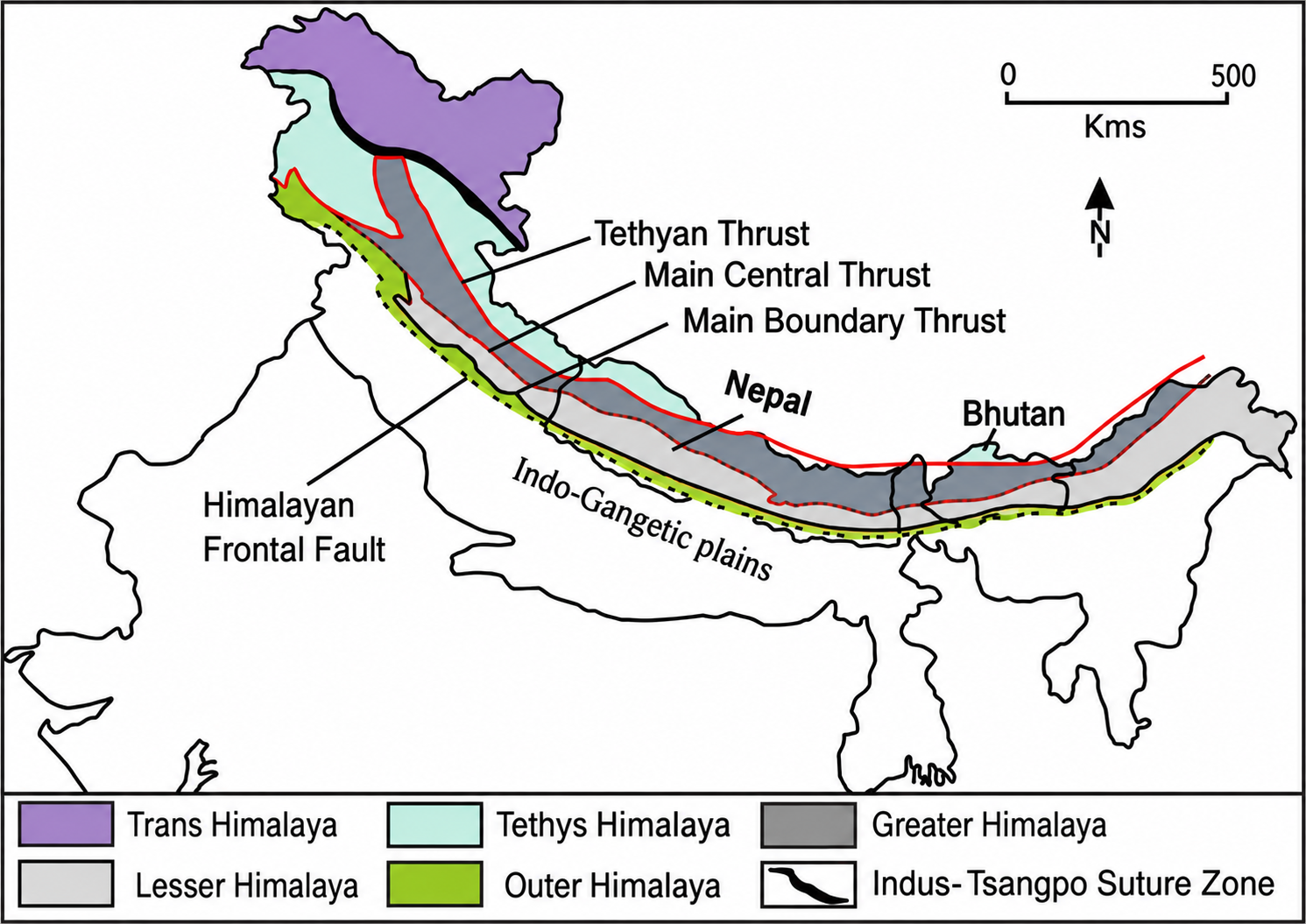
Himalayas Major Mountain Ranges
The major Himalayan ranges are arranged broadly parallel to one another and differ in elevation, geological structure, climate and ecological characteristics.
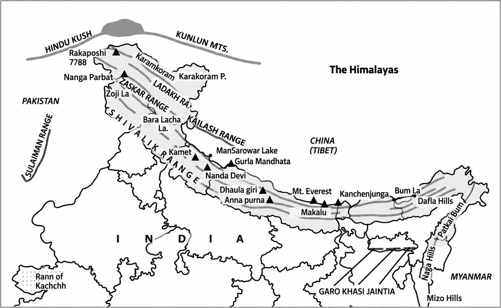
Trans-Himalayas
The Trans-Himalayas lie north of the main Himalayan ranges and include some of the highest and most rugged mountain landscapes of the region. Important ranges include
- Karakoram Range: A high mountain system containing K2 and extensive glaciers.
- Ladakh Range: A high-altitude range mainly associated with Ladakh, characterised by a cold and dry environment.
- Zanskar Range: A major high-altitude range south of the Indus Valley, separating the Ladakh region from the Great Himalaya.
- Kailash Range: A high mountain system in the trans-Himalayan region associated with important religious and geographical landscapes.
Greater Himalayas or Himadri
- The Greater Himalayas form the highest and most continuous Himalayan range, containing numerous permanently snow-covered peaks and major glaciers.
- Important peaks associated with this zone include Mount Everest, Kangchenjunga, Lhotse, Makalu and Dhaulagiri. Mount Everest, at about 8,849 m, is the highest mountain on Earth.
- The Greater Himalayas (Himadri) pass through multiple states and union territories in India, alongside neighbouring countries like Nepal, Bhutan, and China.
- In India specifically, the main states and union territories containing portions of the Greater Himalayan range include Jammu & Kashmir, Ladakh, Himachal Pradesh, Uttarakhand, Sikkim, and Arunachal Pradesh
Lesser Himalayas or Himachal
The Lesser Himalayas occupy the zone between the Greater Himalayas and the Shiwaliks and contain numerous ranges, valleys and hill stations. Important ranges include:
- Pir Panjal Range: A major western Himalayan range extending across Jammu and Kashmir and Himachal Pradesh.
- Dhauladhar Range: A prominent Himachal Pradesh range rising sharply above the Kangra Valley.
- Kumaon Hills: Important Himalayan hills of Uttarakhand containing several high mountain valleys and peaks.
- Nag Tibba Range: A lower/lesser Himalayan range in Uttarakhand with forested mountain slopes.
- Mussoorie Range: A Himalayan hill system associated with the Mussoorie region.
- Mahabharat Range: A major middle-Himalayan range extending across Nepal.
Shiwalik or Outer Himalayas
- The Shiwaliks form the southernmost and generally lowest Himalayan range, consisting substantially of younger and relatively unconsolidated sediments.
- They contain longitudinal valleys known as Duns, including the Dehradun Valley, and are particularly susceptible to erosion and landslides because of their geological composition.
- The Shivalik range passes through parts of Jammu and Kashmir, Himachal Pradesh, Uttarakhand, Punjab, Haryana, and Uttar Pradesh in India, as well as extending into neighbouring countries like Nepal, Pakistan, and Bhutan.


Himalayas Regional Divisions
Regional Himalayan divisions help explain geographical differences in climate, relief, vegetation, drainage and human activities along the mountain arc. For geographical study, the Himalayas are commonly divided into regional sectors such as
- Kashmir Himalayas: The Kashmir Himalayas occupy the northwestern part of the Himalayan system and include the Pir Panjal, Kashmir Valley and high mountain landscapes of Jammu and Kashmir.
- Himachal Himalayas: The Himachal Himalayas cover the Himalayan region of Himachal Pradesh and include the Dhauladhar, Pir Panjal and Great Himalayan ranges.
- Kumaon Himalayas: Cover the Kumaon region of Uttarakhand and include important ranges and peaks of eastern Uttarakhand.
- Garhwal Himalayas: Cover the Garhwal region of Uttarakhand and include important peaks such as Nanda Devi, Kamet and Chaukhamba.
- Nepal Himalayas: The Nepal Himalayas occupy the central Himalayan sector and contain some of the world's highest peaks, including Mount Everest.
- Assam or Eastern Himalayas: The Eastern Himalayas extend towards Arunachal Pradesh, Bhutan and the eastern Himalayan bend, where the mountain system undergoes a major change in direction and connects with the northeastern mountain systems.
Himalayas Drainage System
The Himalayan drainage system is a vast network of perennial rivers supplied by melting snow, glaciers, and monsoon rains, primarily comprising the Indus, Ganga, and Brahmaputra river basins.
Major River Systems in the Himalayan Drainage System
- Indus River System: Originates near Lake Mansarovar in Tibet, flows northwest into Ladakh, and enters Pakistan with major tributaries like the Jhelum, Chenab, Ravi, Beas, and Sutlej.
- Ganga River System: Rises from the Gangotri Glacier as the Bhagirathi, joins the Alaknanda at Devprayag, and is fed by major left-bank (Ghaghara, Gandak, Kosi) and right-bank (Yamuna, Son) tributaries.
- Brahmaputra River System: Originates from the Chemayungdung glacier in the Kailash range, flows through Tibet (as Tsangpo), enters India in Arunachal Pradesh (as Dihang), and joins the Ganga in Bangladesh.
Key Features of the Himalayan Drainage System
- Perennial Flow: Water flows throughout the year due to glacial melt during dry summer months and monsoon precipitation.
- Youthful Topography: In the mountains, rivers feature steep gradients, fast flows, and intense vertical erosion that carve deep V-shaped valleys, gorges, and canyons.
- Depositional Plains: Upon entering the northern plains, they form flat valleys, meanders, oxbow lakes, braided channels, and large deltas like the Sundarbans.
- Antecedent Drainage: Many rivers, such as the Indus and Brahmaputra, are older than the Himalayas themselves, maintaining their original courses while the mountains uplifted around them.
Glaciers of the Himalayas
The Himalayan glacier system extends across the Indus, Ganga and Brahmaputra basins, with thousands of glaciers distributed across the Himalaya and adjoining Trans-Himalayan ranges. The Himalayan Glacier Information System of ISRO provides baseline information for about 35,000 glaciers across these three major river basins and 55 sub-basins.
| Glacier | Region | Importance/Feature |
|
Siachen Glacier |
Karakoram |
One of the major glaciers of the Karakoram region and an important high-altitude glacier system. Nubra River → Shyok → Indus |
|
Gangotri Glacier |
Uttarakhand |
An important glacier of the Bhagirathi basin and associated with the source region of the Ganga system. |
|
Zemu Glacier |
Sikkim |
A major glacier of the eastern Himalayas and an important source of water for the Teesta system. |
|
Milam Glacier |
Uttarakhand |
A major glacier of the Kumaon Himalayas associated with the Gori Ganga basin. |
|
Bara Shigri Glacier |
Himachal Pradesh |
A major glacier of the Chandra Basin and one of the important glaciers monitored for long-term glaciological studies. |
|
Pindari Glacier |
Uttarakhand |
Located in the Kumaon Himalayas and associated with the Pindar River system. |
|
Kedarnath Glacier |
Uttarakhand |
A mapped glacier in the Uttarakhand Himalaya, in the Rudra Prayag district, in the Mandakini basin. |
|
Dokriani Glacier |
Uttarakhand |
Located in the Bhagirathi basin and monitored for glacier retreat and mass-balance studies. |
|
Durung-Drung Glacier |
Ladakh |
A major glacier in the Suru basin is monitored for changes in glacier dimensions. |
|
Pensilungpa Glacier |
Ladakh |
Located in the Suru basin and monitored for glacier retreat. |
Himalayas as a Biodiversity Hotspot
The Himalayas are recognised as a global biodiversity hotspot due to their exceptional species richness, endemism and habitat diversity.
- High Species Diversity: The Himalayas support a wide variety of flora and fauna across different elevations.
- For example, Uttarakhand's Nanda Devi Biosphere Reserve supports species such as the snow leopard, Himalayan musk deer and Himalayan tahr. Also, Hemis National Park in Ladakh is an important habitat for the snow leopard, while Singalila National Park in West Bengal supports the red panda.
- Rich Floral Diversity: Variation in altitude creates distinct vegetation zones, from subtropical forests to alpine meadows.
- For example, Valley of Flowers National Park in Uttarakhand is renowned for its diverse alpine flowering plants.
- Endemic Species: Several species have restricted geographical ranges within the Himalayan region.
- For example, the Cheer Pheasant is a rare, vulnerable bird found along the scrubby lower and middle western Himalayan slopes.
- Habitat Diversity: The Himalayas contain forests, grasslands, wetlands, alpine meadows and high-altitude ecosystems.
- For example, Khangchendzonga National Park in Sikkim encompasses diverse ecosystems ranging from subtropical forests to alpine and high-altitude areas.
- Eastern Himalayas: The Eastern Himalayas are particularly rich in biodiversity and overlap with the Indo-Burma biodiversity hotspot in parts of the region.
- For example, Namdapha National Park in Arunachal Pradesh supports tropical forests as well as high-altitude habitats and species such as the red panda and clouded leopard.
- Conservation Significance: Protected areas and wildlife corridors are crucial for maintaining Himalayan biodiversity.
- For example, the Khangchendzonga Landscape provides transboundary connectivity across India, Nepal and Bhutan, supporting habitat and wildlife conservation.
Himalayas Major Passes
Himalayan passes are important natural routes through the mountain system and have historically supported trade, migration, pilgrimage and strategic connectivity.
| Pass | Location/Region | Significance |
|
Karakoram Pass |
Ladakh |
Historic route connecting Ladakh with the Tarim Basin; strategically important |
|
Zoji La |
Jammu & Kashmir–Ladakh |
Connects Kashmir Valley with Ladakh |
|
Banihal Pass |
Jammu & Kashmir |
Traditional route connecting Jammu with the Kashmir Valley |
|
Rohtang Pass |
Himachal Pradesh |
Connects Kullu Valley with Lahaul-Spiti |
|
Baralacha La |
Himachal Pradesh |
Important route on the Manali–Leh corridor |
|
Shipki La |
Himachal Pradesh |
Border pass connecting Himachal Pradesh with Tibet; trade route |
|
Mana Pass |
Uttarakhand |
High-altitude pass near the India–Tibet border |
|
Niti Pass |
Uttarakhand |
Traditional route connecting Uttarakhand with Tibet |
|
Lipulekh Pass |
Uttarakhand |
Important route towards Tibet; associated with the Kailash Mansarovar pilgrimage |
|
Nathu La |
Sikkim |
Connects Sikkim with Tibet; important border trade route |
|
Jelep La |
Sikkim |
Historic trade route connecting Sikkim with Tibet |
|
Bomdi La |
Arunachal Pradesh |
Important mountain pass on the route towards Tawang |
|
Se La |
Arunachal Pradesh |
Important strategic pass connecting Tawang with the rest of Arunachal Pradesh |
Himalayas' Ecological Significance
The ecological significance of the Himalayas arises from their exceptional variation in altitude, climate, forests, grasslands, glaciers and freshwater ecosystems.
- The region contains ecosystems ranging from tropical and subtropical forests to temperate forests, alpine meadows and high-altitude environments. WWF reports that the Eastern Himalayas alone support about 10,000 plant types, 300 mammals, nearly 980 birds, 175 reptiles, 105 amphibians and 270 freshwater fish.
- Important species associated with Himalayan ecosystems include:
- Snow leopard
- Red panda
- Tiger
- Asian elephant
- Greater one-horned rhinoceros
- Wild water buffalo
- Himalayan birds and amphibians
- The region also supports numerous endemic and threatened species, making habitat connectivity and ecosystem conservation particularly important
Himalayas' Importance
The importance of the Himalayas extends from climate regulation and freshwater supply to biodiversity conservation, agriculture, energy, tourism, culture and national security.
- Water Security: Himalayan glaciers, snow and precipitation feed major river systems of Ganga, Indus and Brahmaputra that support large downstream populations and agricultural regions.
- Climate Regulation: The mountain system influences atmospheric circulation, precipitation and regional climate while acting as a major barrier against freezing, dry winds from Central Asia, Siberia and Tibet, keeping winter temperatures in South Asia much milder.
- Agriculture: Himalayan rivers provide irrigation water to the extensive agricultural plains downstream, while mountain communities practise diverse forms of agriculture and horticulture.
- Biodiversity: The sharp variation in altitude and climate creates multiple ecological zones and habitats, supporting exceptional biodiversity.
- Hydropower: Steep gradients and perennial rivers provide considerable potential for hydropower generation, although projects need careful environmental and geological assessment.
- Tourism: Mountaineering, trekking, pilgrimage, skiing and nature-based tourism contribute to regional livelihoods and economies.
- Cultural Significance: The Himalayas contain numerous sacred landscapes, pilgrimage centres, monasteries, lakes and traditional cultural sites. Himalayan communities have developed livelihood practices closely connected with their natural environment.
- Strategic Significance: The Himalayan frontier has major importance for India's national security because of its difficult terrain, international boundaries and proximity to neighbouring countries.
Himalayas Major Threats and Concerns
The major threats to the Himalayas result from the interaction of geological fragility, climate change, land-use transformation, infrastructure development and increasing human pressure. Key concerns include
- Deforestation and habitat degradation: Forest loss and land-use changes can fragment ecosystems and increase erosion.
- Landslides: Steep slopes, geological instability, intense rainfall and human interventions increase landslide vulnerability.
- Floods and flash floods: Extreme rainfall, rapid snow and ice melt and unstable slopes can intensify downstream hazards.
- Glacial hazards: Changing glaciers and glacial lakes create risks, including Glacial Lake Outburst Floods.
- Water insecurity: Changes in precipitation, glacier and snow dynamics and declining springs can affect water availability.
- Infrastructure pressure: Roads, hydropower projects, settlements and tourism infrastructure can disturb fragile mountain environments.
- Illegal resource extraction: Unsustainable extraction of timber and wildlife threatens biodiversity, particularly in the Eastern Himalayas.
- Human-wildlife conflict: Habitat fragmentation and expanding human activity increase interaction between people and wildlife.
- Waste and pollution: Growing tourism and urbanisation create additional pressure on mountain ecosystems.
- Seismic hazards: Continuing plate convergence makes the Himalayan region highly tectonically active.
Himalayas and Climate Change
Climate change is affecting Himalayan glaciers, snow cover, water resources, ecosystems, agriculture and mountain communities, increasing risks across the region. Major climate-change impacts include
- Glacier retreat: Rising temperatures contribute to glacier mass loss and retreat.
- Changing snowfall: Altered temperature and precipitation patterns can modify snow accumulation and melt.
- Changing river flows: Earlier snow and glacier melt can alter seasonal water availability.
- Glacial Lake Outburst Floods: Growth and instability of glacial lakes can increase downstream risks.
- Extreme rainfall: Intense rainfall can trigger landslides, flash floods and debris flows.
- Ecosystem shifts: Species may move towards higher elevations as temperature conditions change.
- Agricultural impacts: Changes in temperature, precipitation and water availability affect mountain farming.
- Spring depletion: Climate change combined with land-use change and human pressure can reduce spring discharge.
- Biodiversity stress: Species such as snow leopards and red pandas face additional habitat pressures.
Himalayas Conservation and Government Initiatives
India has established several programmes and institutions to address Himalayan ecology, climate vulnerability, scientific research and sustainable development.
- National Mission for Sustaining the Himalayan Ecosystem: The National Mission for Sustaining the Himalayan Ecosystem (NMSHE) is a component of India's National Action Plan on Climate Change (NAPCC).
- It focuses on scientific knowledge, ecosystem monitoring, vulnerability assessment, adaptation and conservation of the Himalayan ecosystem.
- National Mission on Strategic Knowledge for Climate Change: The National Mission on Strategic Knowledge for Climate Change (NMSKCC) supports research and capacity building related to climate change, including impacts and adaptation in Himalayan regions.
- SECURE Himalaya: It stands for “Securing Livelihoods, Conservation, Sustainable Use and Restoration of High Range Himalayan Ecosystems” and was a Government of India–UNDP–GEF initiative focused on conserving high-altitude Himalayan ecosystems while supporting sustainable livelihoods.
- The project ran from 2017 to December 2025.
- National Mission on Himalayan Studies: The Ministry of Environment, Forest and Climate Change launched the National Mission on Himalayan Studies in 2015 to strengthen research and sustainable management of natural resources in the Indian Himalayan Region.
- State Climate Change Cells: Under NMSHE, State Climate Change Centres have been established or strengthened across the 13 Himalayan States/UTs to support vulnerability assessment, capacity building, disaster-risk reduction and climate-resilience planning.
- Glacial Monitoring and GLOF Risk Reduction: Government agencies are undertaking glacier and glacial-lake monitoring, including inventories, satellite-based assessment and early-warning systems.
- The Wadia Institute of Himalayan Geology also contributes to glacier monitoring and hazard analysis, while NDMA has issued guidelines for managing GLOF and related risks.
Himalayan Conclave 2025
- In November 2025, the G.B. Pant National Institute of Himalayan Environment organised a Himalayan Conclave focused on developing a strategic vision for the Indian Himalayan Region up to 2047.
- Discussions covered biodiversity, climate adaptation, land and water management, sustainable livelihoods, governance, responsible tourism and community participation.
Himalayas Way Forward
The way forward for the Himalayas requires development strategies that combine ecological security, disaster resilience, scientific evidence and sustainable livelihoods.
- Adopt mountain-specific planning: Development projects should reflect the geological and ecological sensitivity of individual Himalayan zones.
- Strengthen carrying-capacity assessments: Tourism, construction and urban expansion should remain within locally appropriate ecological limits.
- Improve disaster preparedness: Expand landslide, flood, earthquake and GLOF hazard mapping and early-warning systems.
- Protect forests and wildlife corridors: Maintain habitat connectivity and strengthen community-based conservation.
- Secure mountain water: Protect springs, watersheds, wetlands, glaciers and traditional water systems.
- Promote climate-resilient agriculture: Encourage suitable crops, agroforestry and improved water-management practices.
- Regulate infrastructure: Roads, hydropower and urban projects should incorporate detailed geological, ecological and cumulative-impact assessments.
- Promote responsible tourism: Tourism should generate local livelihoods without exceeding the ecological capacity of mountain destinations.
- Strengthen scientific monitoring: Expand glacier, snow, biodiversity, hydrological and climate observation networks.
- Empower local communities: Traditional knowledge and community institutions should be incorporated into conservation and adaptation planning.
- Enhance regional cooperation: Himalayan ecosystems and river systems cross national boundaries, requiring scientific data sharing and coordinated conservation.
Himalayas UPSC PYQs
Q1. How will the melting of Himalayan glaciers have a far-reaching impact on the water resources of India? (UPSC Mains 2020)
Q2. Consider the following pairs: (UPSC Prelims 2020)
| Peak | Mountains |
|
1. Namcha Barwa |
Garhwal Himalaya |
|
2. Nanda Devi |
Kumaon Himalaya |
|
3. Nokrek |
Sikkim Himalaya |
Which of the pairs given above is/are correctly matched?
a) 1 and 2
b) 2 only
c) 1 and 3
d) 3 only
Ans: (b)
Q3. Siachen Glacier is situated to the: (UPSC Prelims 2022)
a) East of Aksai Chin
b) East of Leh
c) North of Gilgit
d) North of Nubra Valley
Ans: (d)
Q4. When you travel in Himalayas, you will see the following: (UPSC Prelims 2012)
- Deep gorges
- U-turn river courses
- Parallel mountain ranges
- Steep gradients causing landsliding
Which of the above can be said to be the evidence for Himalayas being young fold mountains?
a) 1 & 2 Only
b) 1, 2 & 4 Only
c) 3 & 4 Only
d) 1, 2, 3 & 4
Ans: (d)

 Last updated on Oct, 2026
→ UPSC 2027 Notification will be released on 13 January 2027 at upsconline.nic.in.
→ Check Nobel Prize 2026 Winners List here.
→ Download PIB PRiSM Monthly Magazine 2026 here.
→ Check UPSC Monthly Current Affairs Magazine The Recitals here.
→ Check out the latest UPSC Syllabus here.
→ Download UPSC Model Answers for Mains 2026
→ UPSC Mains Question Paper 2026 is out now for Essay & GS Paper 1, 2, 3 & 4.
→ UPSC Calendar 2027 has been released.
→ Enroll in Vajiram & Ravi’s UPSC Mains Test Series 2027 for structured answer writing practice, expert evaluation, and exam-oriented feedback.
→ Join Vajiram & Ravi’s UPSC Mentorship Program 2027 for personalized guidance, strategy planning, and one-to-one support from experienced mentors.
→ Go through the UPSC Mains Previous Year Papers to enhance your preparation.
→ UPSC has released UPSC Toppers List 2025 with the Civil Services final result on its official website.
→ Also check Best UPSC Coaching in India
Himalayas FAQs
Q1. Which countries are in the Himalayas?+
Q2. How old are the Himalayas?+
Q3. Which is the highest mountain in the Himalayas?+
Q4. What are the Trans-Himalayas?+
Q5. What is the largest city in the Himalayas?+
Tags: himalayas quest UPSC Geography Notes