The physiography of India reflects a long geological evolution shaped by tectonic movements, weathering, erosion and deposition, resulting in diverse landforms and regional landscapes. The physiography of India is broadly divided into six major physiographic divisions - the Northern and North-eastern Mountains, Northern Plains, Peninsular Plateau, Indian Desert, Coastal Plains and Islands. Each division possesses distinct geological structures, relief features, drainage systems, soils, natural resources and ecological characteristics.
These physical regions significantly influence agriculture, water availability, biodiversity, mineral resources, settlement patterns, transport and economic activities. At the same time, they face region-specific challenges such as landslides, floods, soil erosion, desertification, mining pressures, coastal erosion, cyclones and ecosystem degradation. Understanding the physiography of India is therefore essential for sustainable resource management, disaster resilience, environmental conservation and balanced regional development.
Physiography of India Meaning
Physiography of India describes the physical form, relief and landforms of the country resulting from geological structure, geomorphic processes and the stage of landscape development.
- The term 'physiography' refers to the physical features and relief of a region. In India, physiography has been shaped by the interaction of endogenic forces, such as tectonic movements, and exogenic processes, including weathering, erosion and deposition.
- India displays considerable physical diversity, ranging from the rugged Himalayan mountains in the north to the stable Peninsular Plateau in the south, with extensive plains lying between them.
Physiography of India Overview
With vast and varied geographical extent, the physiography of India can be understood through its location, latitudinal and longitudinal spread, major physical extremes, important lines of latitude and key geographical routes.
- Latitudinal extent: The Indian mainland extends from 8°4′N to 37°6′N. Including the islands, India extends farther south to about 6°45′N at Indira Point, Great Nicobar.
- Longitudinal extent: The mainland extends from 68°7′E to 97°25′E.
- North–South extent: India measures about 3,214 km from north to south.
- East–West extent: India measures about 2,933 km from east to west.
- Northernmost point of India: Indira Col in the Karakoram, Ladakh, is generally identified as India's northernmost point.
- Southernmost point of India: Indira Point, Great Nicobar, is the southernmost point of India.
- Southernmost point of mainland India: Kanyakumari, Tamil Nadu.
- Westernmost point: Guhar Moti, Gujarat, in the Kutch region.
- Easternmost point: Kibithu/near Kibithu in Anjaw district, Arunachal Pradesh, is commonly identified as India's easternmost inhabited/land point; the exact geographical extreme is associated with the eastern Arunachal Pradesh–Myanmar frontier.
- Highest point associated with India: K2 (8,611 m) in the Karakoram range.
- Lowest point: The Kuttanad region of Kerala contains land lying below sea level, with some areas around −2.2 m.
Important Latitudes and Longitudes
- Equator (0°): Does not pass through India; it lies south of the Indian mainland.
- Tropic of Cancer (23°30′N): It passes approximately through the central part of India from west to east. The Tropic of Cancer divides the country broadly into a tropical southern part and a subtropical/temperate northern part.
- States crossed by the Tropic of Cancer: From west to east
- Gujarat
- Rajasthan
- Madhya Pradesh
- Chhattisgarh
- Jharkhand
- West Bengal
- Tripura
- Mizoram
- Tropic of Capricorn (23°30′S): Does not pass through India. It lies entirely south of the Indian mainland and passes through countries such as Australia, South Africa and Brazil.
- Indian Standard Meridian: 82°30′E is the basis for Indian Standard Time (IST), and it passes near Mirzapur, Uttar Pradesh, which is the standard reference. It also passes through Madhya Pradesh, Chhattisgarh, Odisha and Andhra Pradesh.
Delhi: Important Latitude and Longitude
- Latitude of Delhi: Approximately 28°36′N.
- Longitude of Delhi: Approximately 77°13′E.
- Important point: Delhi lies north of the Tropic of Cancer, which is at approximately 23°30′N.
- Cities lying roughly around the latitude of Delhi: Jaipur, Agra, Lucknow and Patna lie within the broad northern Indian latitudinal belt, although none has exactly the same latitude as Delhi.
- Cities close to Delhi's longitude: Bhopal, parts of Rajasthan, and Bengaluru lie relatively close to Delhi's longitude, while the 82°30′E Standard Meridian lies considerably farther east.
Largest and Smallest States
- Largest Indian state by area: Rajasthan.
- Smallest Indian state by area: Goa.
- Largest state by population: Uttar Pradesh.
- Smallest state by population: Sikkim.
Important Physiographic Extremes
- Lowest land: Parts of Kuttanad, Kerala, lie below mean sea level.
- Longest coastline among states: Gujarat has the longest coastline among Indian states (2,340.62 km as per reassessed estimates).
- Largest state: Rajasthan, characterised largely by the Thar Desert and extensive arid landscapes.
- Smallest state: Goa, located along the Konkan Coast.
Other Important Location Facts
- India's northern boundary: Dominated by the Himalayan mountain system.
- India's southern boundary: Opens into the Indian Ocean, with the Arabian Sea to the west and the Bay of Bengal to the east.
- Western water body: Arabian Sea.
- Eastern water body: Bay of Bengal.
- Ten Degree Channel: Separates the Andaman Islands from the Nicobar Islands.
- Nine Degree Channel: Separates Minicoy from the main Lakshadweep group.
- Palk Strait: Separates India and Sri Lanka.
- Gulf of Mannar: Lies between southeastern India and Sri Lanka.
- Gulf of Kachchh: Located along the Gujarat coast.
- Gulf of Khambhat: Located on the Gujarat coast between the Saurashtra Peninsula and mainland Gujarat.
- Siliguri Corridor: The narrow land connection linking India's northeastern states with the rest of mainland India through West Bengal.


Physiography of India Divisions Basis
The basis of physiographic divisions of India lies in differences in geological structure, rock formations, relief and geomorphic processes that have shaped the country over geological time. The present relief of India has developed through:
- Geological differences: Landforms have evolved during different geological periods.
- Tectonic movements: The northward movement of the Indian Plate contributed to the formation and evolution of major mountain systems.
- Weathering: Rocks are gradually broken down through physical, chemical and biological processes.
- Erosion: Weathered materials are transported by rivers, glaciers, wind and other natural agents.
- Deposition: Rivers and other agents deposit sediments, contributing to the formation of plains and other landforms.
Physiography of India Divisions
Physiographic divisions of India comprise six broad regions that together represent the country’s major variations in relief, geological structure, climate, drainage and natural resources. India is broadly divided into:
- Northern and North-eastern Mountains
- Northern Plains
- Peninsular Plateau
- Indian Desert
- Coastal Plains
- Islands
Northern and North-eastern Mountains
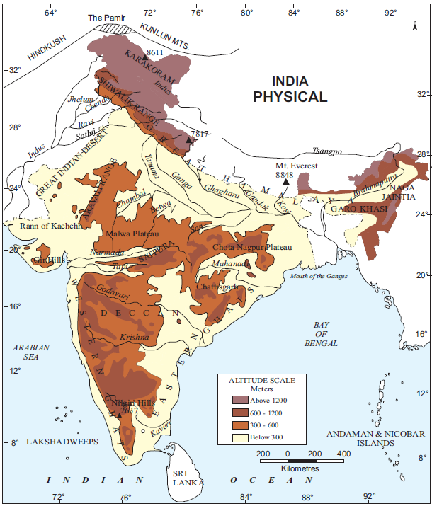
The Northern and North-eastern Mountains comprise the Himalayas and associated northeastern hill systems, forming a major physical, climatic and drainage divide for India. The northern mountain system can be further understood through three major groups:
Himalayas
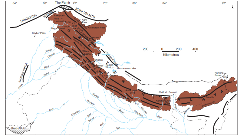
- The Himalayas are young fold mountains extending broadly from the Indus to the Brahmaputra, forming a major mountain barrier along India’s northern boundary.
- The Himalayan system extends for approximately 2,400 to 2,500 km.
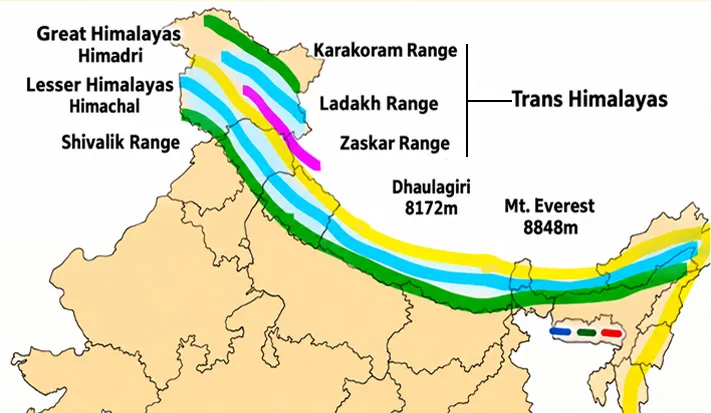
- Its width varies considerably, with the source noting approximately 400 km in the west and 150 km in the east. The Himalayas are divided into three parallel ranges:
- Greater Himalayas or Himadri: The northernmost and most continuous Himalayan range.
- Average elevation is around 6,000 metres.
- Width is approximately 120–190 km.
- It remains largely snow-covered and contains numerous glaciers.
- Important high peaks include Mount Everest, Kanchenjunga, Makalu, Dhaulagiri and Nanga Parbat.
- Important mountain passes include Bara Lacha-La, Shipki-La, Nathu-La, Zoji-La and Bomdi-La.
- The Ganga and Yamuna originate in this broader Himalayan region.
- Lesser Himalayas or Himachal: Elevation generally ranges between 1,000 and 4,500 metres.
- The average width is around 50 km.
- Important ranges include Pir Panjal, Dhaula Dhar and Mahabharata.
- It contains valleys such as Kashmir, Kullu and Kangra.
- Several important hill stations are located in this zone.
- Outer Himalayas or Siwaliks: The Siwaliks form the outermost Himalayan range.
- Their elevation generally varies between 900 and 1,100 metres.
- Width ranges between 10 and 50 km.
- Longitudinal valleys between the Siwaliks and Lesser Himalayas are known as Duns, such as Dehra Dun, Kotli Dun and Patli Dun.
Trans-Himalayas
The Trans-Himalayan ranges lie north of the Greater Himalayas and include the Zaskar, Ladakh and Karakoram ranges, with the Indus flowing between Zaskar and Ladakh.
- The Karakoram Range occupies the extreme northern part, while K2 is the world’s second-highest peak.
Purvanchal Hills
The Purvanchal Hills form the eastern continuation of the northern mountain system and include the Mishmi, Patkai, Naga and Mizo hills.
- The northeastern hill system also includes the Garo, Khasi and Jaintia Hills of the Meghalaya Plateau.
Northern Plains
The Northern Plains are extensive alluvial plains formed by sediments deposited by the Indus, Ganga and Brahmaputra river systems, making them among India’s most agriculturally productive regions.
- The plains extend approximately 2,400 km from west to east (or up to 3,200 km for the total Indus-Gangetic tract, including portions outside/extending to river mouths).
- Their average width ranges between 150 and 300 km.
- The maximum depth of alluvial deposits ranges between 1,000 and 2,000 metres.
- They include the Bhabar, Tarai and alluvial plains.
- The alluvial plains are further divided into Bhangar and Khadar.
Bhabar
The Bhabar is a narrow belt of approximately 8–10 km along the Shiwalik foothills where rivers deposit rocks and boulders, with some streams disappearing underground.
Tarai
The Tarai lies south of the Bhabar and is approximately 10–20 km wide, where streams re-emerge and create marshy and swampy conditions supporting rich natural vegetation and wildlife.
Bhangar and Khadar
- Bhangar: Older alluvial deposits.
- Khadar: Newer alluvial deposits.
- The plains contain features such as meanders, sand bars, ox-bow lakes and braided channels.
- The Brahmaputra plains are particularly known for riverine islands, sand bars and shifting braided channels.
- The Northern Plains also extend from Punjab to Assam, with a width of about 300 km in the west and 150 km in the east, and identify Punjab, Haryana, Uttar Pradesh, Bihar, West Bengal and Assam as major states associated with the plains
Peninsular Plateau
The Peninsular Plateau is an ancient, relatively stable triangular tableland characterised by plateaus, residual hills, rift valleys, rocky structures and diverse mineral and soil resources.
- The plateau rises from about 150 metres above the river plains to 600–900 metres in many areas. Its outer limits include the Delhi Ridge, Rajmahal Hills, Gir Range and Cardamom Hills, with extensions towards Shillong and Karbi-Anglong. It can broadly be divided into:
- Deccan Plateau
- Central Highlands
- Northeastern Plateau.
Deccan Plateau
-
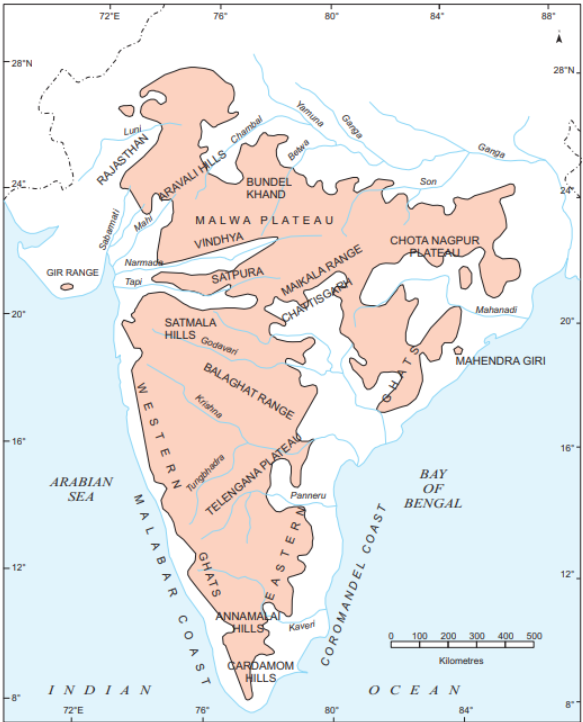
- The Deccan Plateau is bounded by the Western Ghats in the west, the Eastern Ghats in the east, and the Satpura, Maikal and Mahadeo ranges in the north.
- Western Ghats: More continuous and generally higher than the Eastern Ghats.
- Average elevation is approximately 1,200 metres, with higher elevations in the south.
- Elevation increases from north to south.
- Anaimudi at 2,695 metres is the highest peak of the Peninsular Plateau.
- Doddabetta is about 2,637 metres.
- Many Peninsular rivers originate in the Western Ghats.
- Eastern Ghats: Discontinuous and comparatively lower.
-
- They have been considerably eroded by rivers such as the Mahanadi, Godavari, Krishna and Kaveri.
- Important ranges include the Javadi, Palconda, Nallamala and Mahendragiri hills.
- The Eastern and Western Ghats meet around the Nilgiri Hills.
Central Highlands
- The Central Highlands are associated with the Aravallis, Vindhyas, Satpuras, Malwa Plateau and Chotanagpur Plateau.
- Their general elevation ranges between 700 and 1,000 metres, and they slope towards the north and northeast.
- The Chotanagpur region contains substantial mineral resources, while the Narmada valley lies between the Vindhyas and Satpuras.
Northeastern Plateau
- The Northeastern Plateau is an extension of the Peninsular Plateau that became separated from the main block through geological processes associated with the formation of the Himalayas.
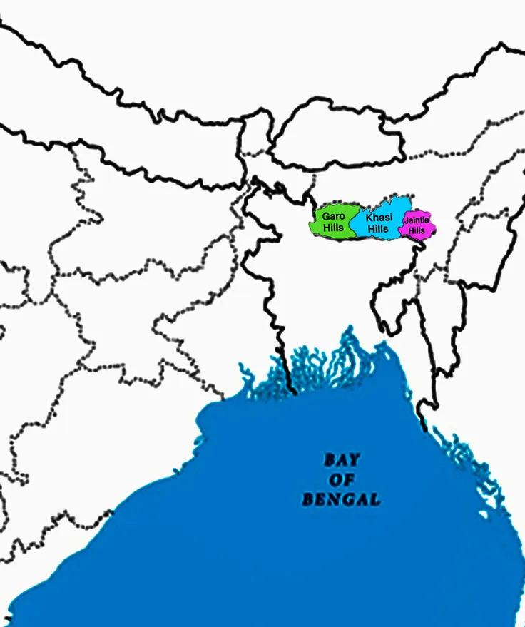
- The Meghalaya Plateau is separated from the main block by the Garo-Rajmahal gap, or Malda Gap and comprises:
- Garo Hills
- Khasi Hills
- Jaintia Hills
- It also extends into Karbi Anglong in Assam and contains minerals such as coal, iron ore, sillimanite, limestone and uranium. Heavy monsoonal rainfall has contributed to substantial erosion of the plateau surface.
Indian Desert
The Indian Desert is located to the northwest of the Aravalli Hills and is characterised by an arid climate, sand dunes, low vegetation and limited surface water availability.
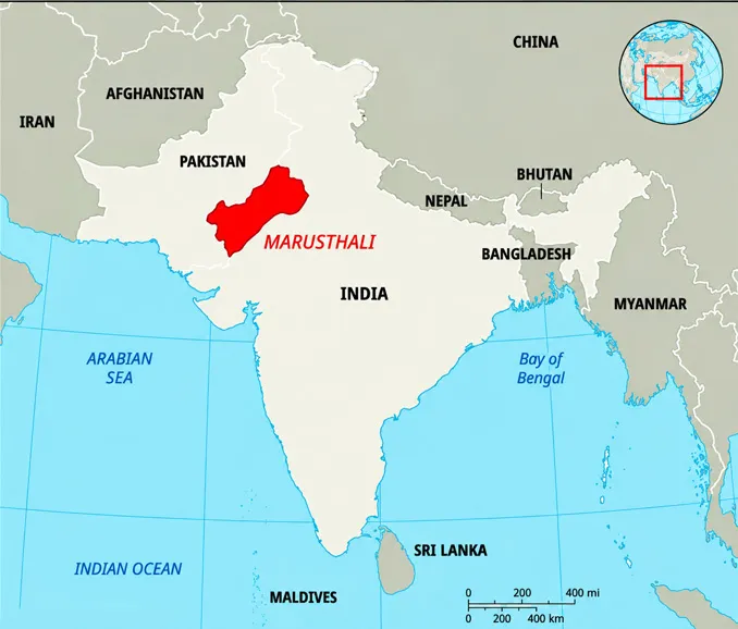
- The region is also known as the Great Indian Desert or Marusthali.
- Receives less than 150 mm of rainfall annually.
- Contains longitudinal dunes and barchans.
- Has landforms such as mushroom rocks, shifting dunes and oases.
- It has mostly ephemeral rivers, with the Luni being an important river.
- Experiences low precipitation and high evaporation, producing water-deficit conditions.
Coastal Plains
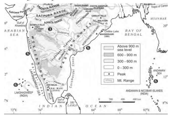
The Coastal Plains are elongated lowland belts along the Arabian Sea and Bay of Bengal, broadly divided into western and eastern coastal plains according to their geomorphological characteristics.
Western Coastal Plains
- The Western Coastal Plains are relatively narrow and submerged coastal plains extending from Gujarat towards Kerala. They include:
- Kachchh and Kathiawar Coast
- Konkan Coast
- Goan Coast
- Malabar Coast
- The western coast provides favourable natural conditions for ports and harbours, including Kandla, Jawaharlal Nehru Port, Marmagao, Mangalore and Cochin.
- The Malabar Coast is particularly known for Kayals, or backwaters, which support fishing, inland navigation and tourism.
Eastern Coastal Plains
- The Eastern Coastal Plains are broader and emergent, with extensive deltas formed by east-flowing rivers such as the Mahanadi, Godavari, Krishna and Kaveri.
- The continental shelf is relatively extensive along this coast, and with sediment deposition, it generally limits natural harbour formation compared with the western coast.
Islands
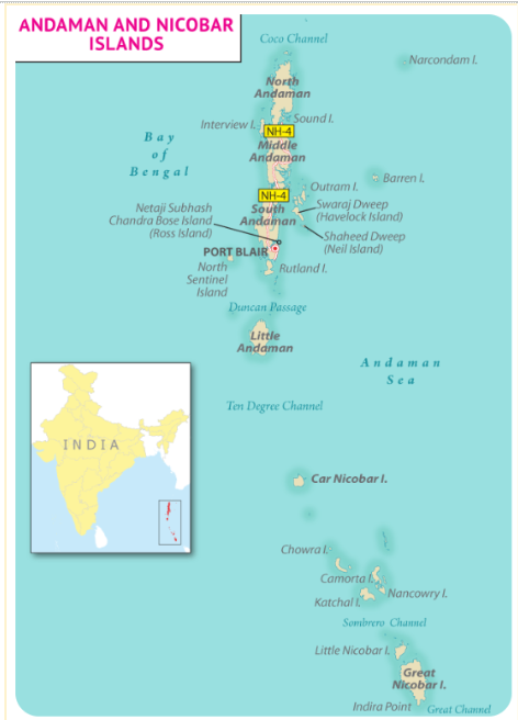
The Indian Islands consist principally of the Andaman and Nicobar Islands in the Bay of Bengal and Lakshadweep in the Arabian Sea, representing distinct geological and ecological environments.
Andaman and Nicobar Islands
- The Andaman Islands and the Nicobar Islands have separated the Andaman Sea to the east from the Indian Ocean.
- The Island group consists of about 836 islands and islets, out of which 31 are inhabited.
- The Ten Degree Channel separates the two groups.
- They are considered elevated portions of submarine mountains, while some smaller islands have volcanic origins.
- Barren Island contains India’s only active volcano.
- The islands contain coral deposits, beaches and equatorial-type vegetation.
Lakshadweep
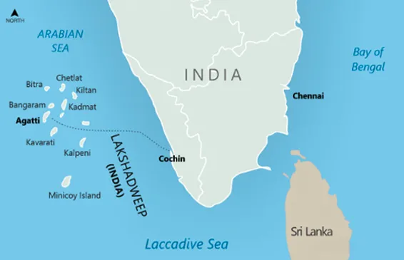
- The Lakshadweep group lies in the Arabian Sea, approximately 220–440 km from the Kerala coast.
- The islands are primarily formed from coral deposits.
- There are approximately 36 islands, of which 10 are inhabited.
- Andrott is identified as the largest island in the group.
- The islands have coral features and beaches and support distinctive marine ecosystems.
Physiography of India Significance
The significance of the physiography of India extends beyond landforms because physical divisions influence agriculture, drainage, climate, biodiversity, settlement patterns, resources, transport and economic activities across the country.
- Agriculture and Food Security: Northern Plains provide fertile alluvial soils for intensive agriculture.
- Black-soil areas of the Peninsular Plateau support crops such as cotton and sugarcane.
- Coastal regions support rice, coconut and spice cultivation.
- Desert regions support specialised arid and semi-arid livelihoods.
- Drainage and Water Resources: Physiography determines river gradients, drainage patterns and water availability. Himalayan rivers are generally perennial, while many peninsular rivers have different seasonal and flow characteristics.
- Mineral Resources: The Peninsular Plateau, particularly regions such as Chotanagpur and Meghalaya, contains important mineral resources, supporting mining and industrial activities.
- Biodiversity: The mountains, plains, plateaus, deserts, coastal ecosystems and islands create diverse ecological conditions and habitats.
- Transport and Trade: Mountain passes facilitate movement across difficult terrain, while coastal plains provide locations for ports and maritime trade. Mountain passes have historically facilitated trade, migration and cultural exchange.
- Human Settlement: Fertile plains have historically supported dense populations, while mountains, deserts and islands have encouraged more specialised settlement and livelihood patterns
Physiography of India Threats
Major threats to India’s physiographic regions arise from natural hazards, geomorphic processes and increasing human pressure, although their nature and intensity vary significantly across different physical divisions.
- Himalayan region: Landslides, erosion, earthquakes, glacier-related hazards and pressure from infrastructure and settlements.
- Northern Plains: Floods, riverbank erosion, shifting channels and waterlogging.
- Peninsular Plateau: Soil erosion, land degradation, mining pressure and local seismic activity.
- Indian Desert: Water scarcity, desertification, wind erosion and shifting dunes.
- Coastal Plains: Coastal erosion, cyclones, storm surges, flooding and salinity.
- Islands: Tsunami, cyclones, sea-level-related risks, coral degradation and excessive tourism pressure.
Physiography of India Way Forward
The way forward for India’s physiographic regions requires region-specific planning that combines ecological conservation, disaster resilience, sustainable resource use and livelihood security.
- Adopt region-specific planning: Development policies should reflect the distinct ecological and geological characteristics of mountains, plains, plateaus, deserts, coasts and islands.
- Strengthen disaster resilience: Hazard mapping, early-warning systems and resilient infrastructure should be prioritised in vulnerable regions.
- Promote sustainable mountain development: Construction and tourism in Himalayan areas should account for geological instability, slope conditions and ecological carrying capacity.
- Improve flood management: Floodplain zoning, wetland conservation, river restoration and better drainage management can reduce risks in the Northern Plains.
- Control land degradation: Soil conservation, watershed management, afforestation and sustainable land-use practices should be strengthened in plateau and arid regions.
- Ensure sustainable mining: Mineral-rich plateau regions require stronger environmental safeguards, rehabilitation of mined areas and community participation.
- Strengthen coastal management: Integrated Coastal Zone Management should balance ports, tourism, fisheries, settlements and ecosystem conservation.
- Protect island ecosystems: Coral reefs, mangroves and other coastal ecosystems should be conserved while tourism is managed according to local ecological conditions.
- Promote water security: Rainwater harvesting, watershed development and efficient irrigation can address water stress, particularly in arid and semi-arid regions.
- Use scientific and local knowledge: Physiographic planning should combine geological and geographical data with community knowledge and local livelihood requirements.
Physiography of India UPSC PYQs
Q1. Among the following cities, which one lies on a longitude closest to that of Delhi? (UPSC Prelims 2018)
a) Bengaluru
b) Hyderabad
c) Nagpur
d) Pune
Ans: (a)
Q2. Which of the following pairs of States of India indicates the easternmost and Westernmost State? (UPSC Prelims 2015)
a) Assam and Rajasthan
b) Arunachal Pradesh and Rajasthan
c) Assam and Gujarat
d) Arunachal Pradesh and Gujarat
Ans: (d)
Q3. Which one of the following pairs of islands is separated from each other by the ‘Ten Degree Channel’? (UPSC Prelims 2014)
a) Andaman and Nicobar
b) Nicobar and Sumatra
c) Maldives and Lakshadweep
d) Sumatra and Java
Ans: (a)

 Last updated on Oct, 2026
→ UPSC 2027 Notification will be released on 13 January 2027 at upsconline.nic.in.
→ Check Nobel Prize 2026 Winners List here.
→ Download PIB PRiSM Monthly Magazine 2026 here.
→ Check UPSC Monthly Current Affairs Magazine The Recitals here.
→ Check out the latest UPSC Syllabus here.
→ Download UPSC Model Answers for Mains 2026
→ UPSC Mains Question Paper 2026 is out now for Essay & GS Paper 1, 2, 3 & 4.
→ UPSC Calendar 2027 has been released.
→ Enroll in Vajiram & Ravi’s UPSC Mains Test Series 2027 for structured answer writing practice, expert evaluation, and exam-oriented feedback.
→ Join Vajiram & Ravi’s UPSC Mentorship Program 2027 for personalized guidance, strategy planning, and one-to-one support from experienced mentors.
→ Go through the UPSC Mains Previous Year Papers to enhance your preparation.
→ UPSC has released UPSC Toppers List 2025 with the Civil Services final result on its official website.
→ Also check Best UPSC Coaching in India
Physiography of India FAQs
Q1. Which is the youngest physiographic division of India?+
Q2. Which is the oldest physiographic division of India?+
Q3. Who is the father of Indian geography?+
Q4. Which is the smallest state of India by area?+
Q5. What is the Indian Standard Meridian?+
Tags: physiography of india quest UPSC Geography Notes