UPSC Daily Quiz 10 November 2025

UPSC Daily Quiz

The Daily UPSC Quiz by Vajiram & Ravi is a thoughtfully curated initiative designed to support UPSC aspirants in strengthening their current affairs knowledge and core conceptual understanding. Aligned with the UPSC Syllabus 2025, this daily quiz serves as a revision resource, helping candidates assess their preparation, revise key topics, and stay updated with relevant issues. Whether you are preparing for Prelims or sharpening your revision for Mains, consistent practice with these Daily UPSC Quiz can significantly enhance accuracy, speed, and confidence in solving exam-level questions.

[WpProQuiz 18]

UPSC Daily Quiz FAQs

Q1: What is the Daily UPSC Quiz?

Ans: The Daily UPSC Quiz is a set of practice questions based on current affairs, static subjects, and PYQs that help aspirants enhance retention and test conceptual clarity regularly.

Q2: How is the Daily Quiz useful for UPSC preparation?

Ans: Daily quizzes support learning, help in revision, improve time management, and boost accuracy for both UPSC Prelims and Mains through consistent practice.

Q3: Are the quiz questions based on the UPSC syllabus?

Ans: Yes, all questions are aligned with the UPSC Syllabus 2025, covering key areas like Polity, Economy, Environment, History, Geography, and Current Affairs.

Q4: Are solutions and explanations provided with the quiz?

Ans: Yes, each quiz includes detailed explanations and source references to enhance conceptual understanding and enable self-assessment.

Q5: Is the Daily UPSC Quiz suitable for both Prelims and Mains?

Ans: Primarily focused on Prelims (MCQ format), but it also indirectly helps in Mains by strengthening subject knowledge and factual clarity.

Aegean Sea, Location, Archipelago, Map, Biodiversity, Significance

Aegean Sea

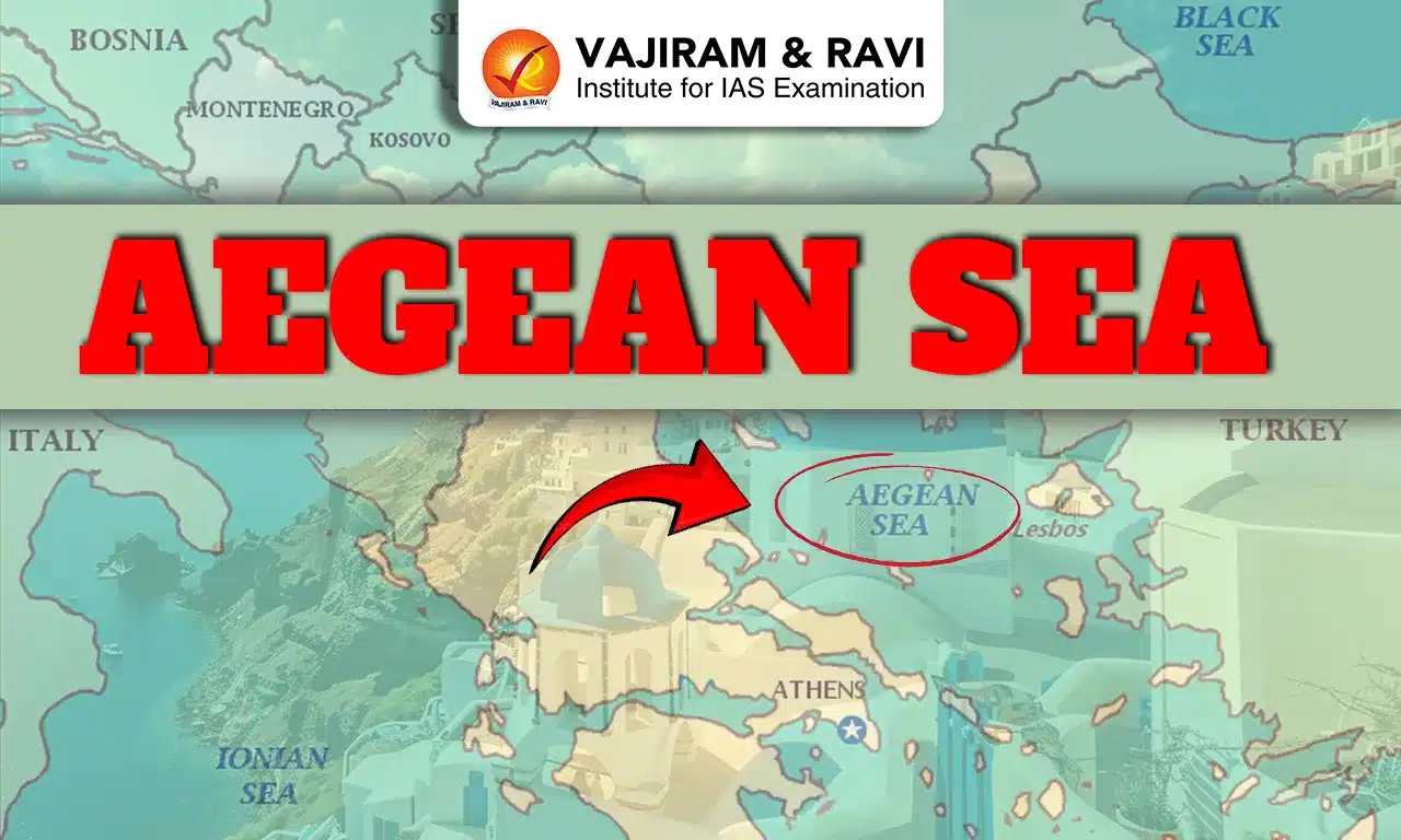
The Aegean Sea is one of the most historically and geographically significant water bodies in the world. Located between Greece and Turkey, it forms a part of the Mediterranean Sea and has been a centre of ancient civilizations, maritime trade, and cultural exchange for thousands of years. Its blue waters, dotted with numerous islands, played a crucial role in shaping the political, economic, and cultural landscape of ancient Europe. This article explains the location, geography, history, ecology, and modern significance of the Aegean Sea in detail.

Aegean Sea

The Aegean Sea lies between the eastern coast of Greece and the western coast of Turkey. It stretches about 610 km (380 miles) from north to south and is roughly 300 km (186 miles) wide. The sea connects to the Mediterranean Sea through the Cretan Sea in the south and to the Marmara Sea and Black Sea through the Dardanelles Strait in the northeast.

The Aegean is known for its clear blue waters, unique marine biodiversity, and thousands of islands that include famous ones such as Crete, Rhodes, Lesbos, and Santorini. These islands have been the cradle of ancient civilizations such as the Minoan and Mycenaean, which later influenced Classical Greek culture.

Also Read: Caribbean Sea

Aegean Sea Treaty

The Aegean Sea Treaty refers to the international agreements that define the maritime boundaries and sovereignty of islands between Greece and Turkey. The main treaties governing this region are the Treaty of Lausanne (1923) and the Treaty of Paris (1947). These treaties established Greece’s control over most Aegean islands while assigning nearby coastal territories to Turkey. However, the treaties left some issues, like continental shelf rights and airspace limits, undefined. Over time, these legal gaps created overlapping territorial claims, leading to ongoing debates about how to apply modern maritime laws, including the United Nations Convention on the Law of the Sea (UNCLOS).

Aegean Sea Dispute

The Aegean Sea Dispute is a long-standing disagreement between Greece and Turkey over control of the sea’s waters, islands, and natural resources. The dispute mainly involves issues like territorial waters, continental shelf boundaries, airspace rights, and exclusive economic zones (EEZs). Greece argues for extending its waters to 12 nautical miles under international law, while Turkey opposes this move, claiming it would restrict its naval access. The conflict also includes exploration rights for oil and gas reserves. Despite several talks under the UN and NATO, the issue remains unresolved, although recent diplomacy has focused on peaceful negotiation and cooperation.

Also Read: Adriatic Sea

Aegean Sea Location

The Aegean Sea is a part of the eastern Mediterranean basin. Its latitude ranges between 35° and 41° North, and longitude between 23° and 27° East. The average depth of the Aegean Sea is about 350 meters (1,150 feet), while its deepest point, known as the Pliny Trench, reaches a depth of around 3,543 meters (11,624 feet) near Crete.

The sea’s irregular coastline and the scattering of over 2,000 islands and islets create a complex maritime geography that has shaped navigation and trade routes since ancient times.

Aegean Sea Formation

The Aegean Sea lies on the Aegean tectonic plate, a part of the complex Mediterranean tectonic region. It was formed millions of years ago due to the collision between the African and Eurasian plates. This tectonic activity continues today, making the region prone to earthquakes and volcanic activity.

Aegean Sea Archipelago

The Aegean Sea Archipelago consists of over 2,000 islands and islets, making it one of the densest island groups in the world. Most of these islands belong to Greece, while a few are under Turkish sovereignty.

The Aegean archipelago forms the backbone of Greece’s maritime identity, contributing to tourism, fishing, and national security. Each island retains unique dialects, traditions, and architecture influenced by ancient Greek, Byzantine, and Venetian cultures.

Aegean Sea Islands

The Aegean Sea islands are divided into several groups based on their location These islands vary in size, culture, and history, contributing to the Aegean’s rich cultural mosaic. Major Islands of the Aegean Sea are:

  • Cyclades: Includes Santorini, Mykonos, Naxos, and Paros; known for ancient architecture and tourism.
  • Dodecanese: Includes Rhodes, Kos, and Patmos; known for medieval history and early Christian influence.
  • Northeastern Aegean Islands: Includes Lesbos, Chios, and Samos; famous for Greek poetry and olive cultivation.
  • Sporades and Euboea: Located near the Greek mainland; lush and green with vibrant local culture.
  • Crete: The largest island, and the cradle of the ancient Minoan civilization (c. 2600-1100 BCE).

Aegean Sea Map

The Aegean Sea Map visually represents one of the most geographically intricate regions in the world. It lies between Greece to the west and Turkey to the east, extending from the Thracian Sea in the north to the Cretan Sea in the south.

These maps are vital for understanding navigation routes, political boundaries, and ecological zones. Modern satellite and hydrographic maps also reveal sea depths, tectonic zones, and marine biodiversity zones across the Aegean basin.

Aegean Sea Map

A map of the Aegean Sea highlights:

  • Major Greek islands: Crete, Rhodes, Lesbos, Samos, Chios, and Santorini.
  • Turkish coastline: Including İzmir, Çanakkale, and Bodrum regions.
  • Key straits and passages: The Dardanelles Strait, linking the Aegean to the Sea of Marmara and ultimately the Black Sea.
  • Strategic locations: Naval bases, major ports, and routes used for commercial shipping and tourism.

Aegean Sea Bordering Countries

The Aegean Sea is bordered mainly by two countries- Greece and Turkey.

  • Greece: Occupies the western and southern boundaries, controlling the majority of the Aegean islands. The sea is central to Greece’s identity, economy, and tourism, with key ports such as Piraeus, Thessaloniki, and Heraklion serving as global maritime hubs.
  • Turkey: Lies to the east of the Aegean and maintains several important coastal cities such as İzmir, Çanakkale, and Bodrum. These areas are significant for trade, tourism, and fishing.
  • Both countries have historical, cultural, and economic ties to the Aegean. However, overlapping Exclusive Economic Zones (EEZs) and continental shelf claims continue to influence diplomatic relations.
  • The European Union, NATO, and United Nations frequently engage in dialogue to promote maritime cooperation and reduce conflict between these bordering nations.

Aegean Sea Biodiversity

The Aegean Sea’s biodiversity is one of the richest in the Mediterranean, encompassing unique flora, fauna, and marine ecosystems. Its combination of warm climate, variable depth, and nutrient circulation supports a wide range of species.

  • Marine Fauna (Animal Life)
    • Over 500 species of fish inhabit the Aegean, including sardines, mackerel, grouper, and red mullet.
    • Marine mammals such as dolphins, fin whales, and sperm whales are commonly spotted.
    • The Mediterranean monk seal (Monachus monachus), one of the world’s rarest seals, finds refuge in remote Aegean islands like Gyaros and Alonissos.
    • Sea turtles, including the loggerhead turtle (Caretta caretta), nest along sandy beaches in the southern Aegean.
  • Marine Flora (Plant Life)
    • Seagrass meadows, particularly of Posidonia oceanica, play a vital ecological role by providing breeding grounds for fish and stabilizing the sea floor.
    • Marine algae and phytoplankton form the base of the food chain, supporting the entire marine ecosystem.
    • Coastal vegetation includes salt-tolerant species such as Tamarix and Salicornia.
  • Avian and Terrestrial Ecosystems
    • The islands and coastal cliffs are home to over 300 species of birds, including seagulls, cormorants, and falcons.
    • Endemic species like the Aegean wall lizard and Greek tortoise thrive in dry, rocky habitats.

Aegean Sea Etymology

The origin of the name “Aegean” has several theories:

  • It may derive from Aegae, an ancient town on the Greek mainland.
  • Another legend links it to Aegeus, the father of King Theseus, who drowned himself in the sea believing his son had died.
  • Some historians also suggest a connection with the Greek word “aiges” meaning “waves.”
  • Thus, the sea’s name is deeply rooted in Greek mythology and ancient heritage.

Aegean Sea Historical Importance

The Aegean Sea has been central to the development of Western civilization. It was the birthplace of major ancient societies and trade routes that shaped history.

  1. Minoan Civilization (c. 2600-1100 BCE): The Minoan civilization, centered on Crete, was the earliest advanced culture in Europe. The Minoans built sophisticated palaces like Knossos, engaged in maritime trade, and dominated the Aegean through their naval power.
  2. Mycenaean Civilization (c. 1600-1100 BCE): After the decline of the Minoans, the Mycenaeans emerged on the Greek mainland. They used the Aegean Sea for trade and warfare, expanding Greek influence across the Mediterranean.
  3. Classical Greek Era (c. 800-300 BCE): During this period, the Aegean was surrounded by powerful city-states such as Athens, Sparta, and Corinth. The sea enabled commerce, colonization, and naval dominance, particularly by Athens, whose fleet made it a maritime superpower.
  4. Roman and Byzantine Periods: Under Roman and later Byzantine rule, the Aegean remained a vital commercial and strategic area connecting Europe with Asia. The islands became centres of Christianity and cultural learning.
  5. Ottoman Era to Modern Times: The Aegean came under Ottoman control in the 15th century and remained so until Greece’s independence in the 19th century. Today, it remains a zone of cooperation and occasional tension between Greece and Turkey.

Aegean Sea Geological Features 

Notable geological features include the Santorini, Hellenic Trench, and numerous Hot Springs.These geological processes have shaped the landscape and continue to influence the Aegean’s environment.

  • Santorini (Thera): Site of a massive volcanic eruption around 1600 BCE, one of the largest in history.
  • Hellenic Trench: A deep oceanic trench formed by plate subduction near Crete.
  • Numerous Hot Springs: Resulting from geothermal activity beneath the seabed.

Aegean Sea Climate

The Aegean Sea region experiences a Mediterranean climate, characterized by:

  • Hot, dry summers (June-September)
  • Mild, wet winters (November-March)

Average summer temperatures range between 25°C and 35°C, while winter temperatures stay between 10°C and 15°C. Seasonal winds known as “Meltemi” blow from the north during summer, cooling the islands but also affecting navigation. This pleasant climate supports tourism, agriculture, and marine life across the Aegean basin.

Aegean Sea Heritage

The Aegean region is rich in cultural and archaeological treasures. These sites showcase the evolution of human civilization, art, and architecture in the Aegean basin. Important sites include:

  • Knossos (Crete): Palace of the Minoan kings.
  • Delos Island: Mythological birthplace of Apollo and Artemis.
  • Santorini (Akrotiri): Well-preserved Bronze Age settlement.
  • Rhodes: Site of the ancient Colossus of Rhodes, one of the Seven Wonders of the Ancient World.

Aegean Sea Economic Importance

The Aegean Sea is vital to the economy of both Greece and Turkey. Its economic contributions include:

  • Maritime Trade: The sea connects Europe, Asia, and Africa, making it a major shipping route.
  • Tourism: Islands like Santorini, Mykonos, and Rhodes attract millions of tourists annually, boosting local economies.
  • Fishing Industry: Thousands depend on fishing for livelihood, contributing significantly to coastal economies.
  • Energy Resources: Recent explorations suggest the presence of natural gas reserves in the northern Aegean.
  • According to the UNWTO and WTTC, 2024, tourism related to the Aegean region contributes over 20-25% of Greece’s GDP, making it a crucial economic zone.

Aegean Sea Geopolitical Significance

The Aegean Sea is not just an economic hub but also a politically sensitive region. Greece and Turkey have longstanding disputes over maritime boundaries, airspace, and continental shelf rights. These disputes have led to tensions but are being managed through diplomatic efforts and international law frameworks such as the United Nations Convention on the Law of the Sea (UNCLOS).

The Aegean also serves as a strategic military zone and a route for global trade and energy transport. NATO and the EU maintain active monitoring due to its importance in regional security.

Aegean Sea Tourism

Today, the Aegean Sea is one of the world’s top travel destinations. Modern ferries, airports, and cruise routes connect major islands and cities. Popular destinations like Santorini, Mykonos, and Rhodes attract global travelers seeking history, beaches, and Mediterranean cuisine.

In 2024, the Greek National Tourism Organization recorded over 40 million international visitors, a large portion visiting Aegean islands. This tourism continues to be a cornerstone of the regional economy.

Aegean Sea Environmental Challenges

Despite its richness, the Aegean’s biodiversity faces serious threats:

  • Overfishing has led to depletion of several fish species.
  • Plastic pollution and oil spills affect water quality.
  • Climate change causes rising sea temperatures and coral decline.
  • Mass tourism and coastal construction threaten fragile ecosystems.
  • Marine Pollution through the coastal waste disposal and ships

Conservation efforts by the Hellenic Centre for Marine Research (HCMR) and the EU’s Marine Strategy Framework Directive aim to protect biodiversity through sustainable fishing, pollution control, and marine reserves.

Aegean Sea UPSC

The Aegean Sea is far more than a geographical feature, it is a living record of human civilization, natural beauty, and ecological diversity. From ancient trade routes and cultural exchanges to modern geopolitical debates and conservation efforts, it continues to shape the history and future of Europe and Asia alike.

Balancing the economic potential, environmental preservation, and peaceful coexistence between its bordering nations will determine the destiny of this iconic sea in the 21st century.

Aegean Sea FAQs

Q1: Where is the Aegean Sea located?

Ans: The Aegean Sea lies between Greece and Turkey, forming part of the eastern Mediterranean Sea, connected to the Black Sea through the Dardanelles Strait.

Q2: Why is the Aegean Sea historically important?

Ans: It was the center of ancient civilizations like the Minoan and Greek empires, which influenced art, trade, and politics across the Mediterranean.

Q3: What are the major islands in the Aegean Sea?

Ans: Major islands include Crete, Rhodes, Santorini, Mykonos, Lesbos, and Samos. Each has unique cultural and historical significance.

Q4: What is the depth of the Aegean Sea?

Ans: The average depth is around 350 meters, while the deepest point, the Pliny Trench near Crete, reaches about 3,543 meters.

Q5: What are the main environmental issues in the Aegean Sea?

Ans: Key issues include overfishing, pollution, climate change, and excessive tourism, all of which threaten the sea’s biodiversity and sustainability.

United Nations Framework Convention on Climate Change (UNFCCC)

United Nations Framework Convention on Climate Change

United Nations Framework Convention on Climate Change Latest News

The world has gathered at the city of Belem in the Brazilian state of Para for the 30th Conference of the Parties (COP30) to the United Nations Framework Convention on Climate Change (UNFCCC).

About United Nations Framework Convention on Climate Change

  • UNFCCC is the principal global treaty for coordinating international responses to climate change. 
  • It provides the foundation for subsequent legal instruments, including the Kyoto Protocol and the landmark Paris Agreement.
  • The purpose of the UNFCCC is to harness international cooperation to limit the rise of average global temperatures to minimize the impacts of climate change to enable timely adaptation, avoid threats to food production, and ensure sustainable economic development. 
  • It is one of three conventions that was adopted at the Rio Earth Summit in 1992 to promote a sustainable planet for future generations. 
  • Its sister Rio Conventions are the UN Convention on Biological Diversity and the Convention to Combat Desertification.
  • The UNFCCC has 198 Parties, comprising 197 States and the European Union, making it one of the most widely ratified international treaties.
  • Every year, parties to the Convention meet in Conference of the Parties (COPs), as well as in technical meetings throughout the year, to advance the aims and ambitions of the Paris Agreement and achieve progress in its implementation. 
  • The UNFCCC relies on the scientific assessments of the Intergovernmental Panel on Climate Change (IPCC) to inform its decisions and guide negotiations. 
    • The IPCC is the United Nations body for assessing the science related to climate change. 
    • It was established by the United Nations Environment Programme (UNEP) and the World Meteorological Organization (WMO) in 1988.

What is the Kyoto Protocol?

  • Adopted in 1997 as part of the UNFCCC, the Kyoto Protocol outlines individual quantitative emission reduction targets for developed countries. 
  • The Protocol required these countries to reduce their emissions by 5% in 2008-2012 compared to 1990 levels.
  • One of the key elements of the Protocol was the implementation of market mechanisms to achieve these commitments. 
  • These include the Clean Development Mechanism (CDM), allowing the development of cost-effective projects to reduce greenhouse gas (GHG) emissions, ensuring mitigation benefits, and creating sustainable economic benefits.

What is the Paris Agreement?

  • The Paris Agreement, adopted in December 2015 at the 21st Conference of the Parties (COP21), highlighted the key role of the Framework Convention (UNFCCC) that it is connected to.
  • The Agreement stresses the principles of the UNFCCC and introduces three goals: 
    • to keep the global temperature increase well below 2°C, with efforts to limit it to 1.5°C; 
    • to strengthen adaptation and resilience capacities; and 
    • to align financial flows with the other goals of the Agreement.
  • The Paris Agreement also innovated by requiring all countries, both developed and developing, to regularly submit "Nationally Determined Contributions" (NDCs). 
  • In the NDCs, each country explains what actions it intends to take to respond to climate change. The implementation of these actions will be accompanied by an enhanced transparency regime.
  • As NDCs are defined by each country, they respect the national reality and sovereignty of each nation.

Source: DTE

United Nations Framework Convention on Climate Change FAQs

Q1: What does UNFCCC stand for?

Ans: United Nations Framework Convention on Climate Change.

Q2: When was the UNFCCC adopted?

Ans: 1992

Q3: What is the principal aim of the UNFCCC?

Ans: To limit the rise of average global temperatures and ensure sustainable development.

Q4: Which scientific body provides assessments to support UNFCCC decisions?

Ans: Intergovernmental Panel on Climate Change (IPCC)

Financial Sector Assessment (FSA) Report

Financial Sector Assessment (FSA) Report

Financial Sector Assessment (FSA) Report Latest News

The latest Financial Sector Assessment (FSA) report has stated that India is achieving its vision to become a $30 trillion economy by 2047. 

About Financial Sector Assessment (FSA) Report

  • It was published by the World Bank.

Key Highlights of the Report

  • India’s financial system has become more resilient, diversified, and inclusive.
  • It acknowledges that financial sector reforms helped India recover from various distress episodes of the 2010s as well as the pandemic.
  • India's 'world class' digital public infrastructure and government programmes have significantly improved access to a wider range of financial services for men and women. 
  • WB welcomed the scale-based regulation for NBFCs which recognises the different needs of this diverse industry.
  • India’s capital markets (equity, government bonds and corporate bonds) have increased from 144 percent to about 175 percent of GDP since the last Financial Sector Assessment Program. 

What is the Financial Sector Assessment Program?

  • It is a joint program of the International Monetary Fund (IMF) and World Bank established in 1999.
  • It is a comprehensive and in-depth assessment of a country’s financial sector.
  • FSAPs in advanced economies are conducted with a focus on assessing the resilience of the financial sector, the quality of the regulatory and supervisory framework, and the capacity to manage and resolve financial crises. 

Source: TH

Financial Sector Assessment (FSA) Report FAQs

Q1: What is the purpose of the Financial Sector Assessment (FSA) Report?

Ans: To evaluate the financial sector's stability and resilience.

Q2: The Financial Sector Assessment (FSA) Report is part of which program?

Ans: Financial Sector Assessment Program (FSAP)

Visible Emission Line Coronagraph

Visible Emission Line Coronagraph

Visible Emission Line Coronagraph Latest News

Recently, scientists at the Indian Institute of Astrophysics (IIA) have collaborated with NASA to estimate the crucial parameters of a coronal mass ejection (CME) by using Visible Emission Line Coronagraph (VELC) payload onboard India’s Aditya-L1 mission.

About Visible Emission Line Coronagraph

  • It is the primary payload of the Aditya-L1 Mission–India’s first mission to observe the Sun from a vantage point 1.5 million kilometres from the earth.

Features of Visible Emission Line Coronagraph

  • It is an internally occulted solar coronagraph capable of simultaneous imaging, spectroscopy, and spectro-polarimetry close to the solar limb.
  • It consists of a coronagraph, spectrograph, polarimetry module, and detectors, aside from auxiliary optics.
  • It is built by the Indian Institute of Astrophysics (IIA) at its CREST (Centre for Research and Education in Science and Technology) campus at Hosakote, Karnataka.

Objectives of Visible Emission Line Coronagraph

  • It will observe the solar corona, which is the tenuous, outermost layer of the solar atmosphere. 
  • VELC can image the solar corona down to 1.05 times the solar radius, which is the closest any such payload has imaged.
  • It will analyze the coronal temperature, plasma velocity, density, etc.
  • It will also study Coronal Mass Ejections (CMEs) and the solar wind.

Source: TH

Visible Emission Line Coronagraph FAQs

Q1: What is the primary objective of the Visible Emission Line Coronagraph (VELC)?

Ans: To observe the solar corona

Q2: What is unique about VELC's imaging capability?

Ans: It can image the solar corona down to 1.05 times the solar radius.

Ricin

Ricin

Ricin Latest News

The Gujarat Anti-Terrorist Squad recently busted a suspected terror syndicate by arresting a 'doctor', who was allegedly preparing the highly lethal chemical poison, 'Ricin', and whose handler is associated with the Islamic State Khorasan Province, and two others.

About Ricin

  • Ricin is a poison found naturally in castor beans. 
  • If castor beans are chewed and swallowed, the ricin that comes out can cause injury. 
  • Ricin can be made from the waste material left over from processing castor beans.
  • Ricin can be in the form of a powder, a mist, or a pellet. 
  • It can also be dissolved in water or weak acid.
  • It is stable under normal conditions. However, it will not work if temperatures are over 80 degrees centigrade (176 degrees Fahrenheit).
  • It is toxic when inhaled, ingested, or injected. 
  • As few as five to ten micrograms per kilogram can be lethal.
  • How Does It Work?
    • Ricin works by getting inside the cells of a person's body and preventing the cells from making the proteins they need. Without the proteins, cells die.
    • Eventually this is harmful to the whole body, and death may occur.
  • It is of special concern because of its potential use as a biological weapon. 
  • Accidental exposure to ricin is rare and results primarily from the ingestion of castor seeds.
  • Treatment
    • No antidote exists for ricin. 
    • Symptomatic ricin poisoning is treated by providing supportive medical care to minimize the effects of the poisoning.

Source: NDTV

Ricin FAQs

Q1: What is the natural source of ricin?

Ans: Castor bean

Q2: What is the primary way ricin harms the human body?

Ans: It prevents cells from making proteins.

Q3: In which physical forms can ricin be found?

Ans: Ricin can be in the form of a powder, a mist, or a pellet.

Nine Years After Demonetisation: Why Cash in Circulation Remains High

Demonetisation

Demonetisation Latest News

  • Currency with the public has risen from ₹17.97 lakh crore in November 2016 to ₹37.29 lakh crore in October 2025, more than doubling since demonetisation. 
  • Although cash holdings surged, the rapid economic growth of over 6% annually has kept the currency-to-GDP ratio below pre-demonetisation levels, indicating that India’s expanding economy has absorbed the rise in currency circulation.

Demonetisation of November 2016

  • On November 8, 2016, Prime Minister Narendra Modi announced the demonetisation of ₹500 and ₹1,000 notes, which made up 86% of the currency in circulation
  • Effective from midnight of November 9, the move aimed to eliminate black money, curb fake currency, promote digital payments, and formalise the Indian economy.

Economic Disruption and Lasting Cash Dependence After Demonetisation

  • The 2016 note ban caused a sharp liquidity crisis, reducing demand and GDP growth by about 1.5%. 
  • Many small businesses shut down amid cash shortages, and long queues formed at banks and ATMs. 
  • Though new notes were introduced later, a mix of cash hoarding and continued reliance on currency pushed the money in public hands above pre-demonetisation levels, showing India’s enduring preference for cash.

Pandemic Led to Surge in Cash Holdings

  • During the Covid-19 lockdown (2020–21), people rushed to keep cash on hand for essentials such as groceries and medicines. 
  • This precautionary behaviour drove a sharp rise in cash with the public, reversing the earlier post-demonetisation decline.

Understanding Currency with the Public and India’s Cash Usage Trends

  • According to the RBI, “currency with the public” is the total currency in circulation (CIC) minus the cash held by banks.
  • CIC includes all notes and coins issued by the central bank used in daily transactions.
  • As of October 17, 2025, cash with the public rose by ₹30,709 crore fortnightly and ₹3.13 lakh crore year-on-year.

Currency-to-GDP Ratio Trends

  • While the absolute amount of currency has increased, strong GDP growth—7.8% in Q1 FY2026—has stabilised the CIC-to-GDP ratio.
  • The ratio climbed from 8.7% (2016–17) to 14.5% (2020–21) during the pandemic, then fell to 11.11% in 2025, indicating a gradual shift towards digital payments.
  • A lower ratio signifies better monetary transmission, reduced cash dependence, and stronger inflation control.

Global Comparison

  • India’s 11.11% currency-to-GDP ratio remains higher than major economies—Japan (9–11%), Eurozone (8–10%), China (9.5%), Russia (8.3%), and the U.S. (7.96%).
  • The higher ratio in India reflects its large informal economy, cash preference, and slower—but improving—digital payment adoption.

Cash Still Dominates Despite Digital Growth

  • Despite efforts to build a “less-cash society,” India’s cash usage remains high.
  • The Unified Payments Interface (UPI) has revolutionised digital payments, processing 185.9 billion transactions in FY25 and growing at a 49% CAGR between FY23–FY25.
  • UPI’s deep penetration in tier-2 and tier-3 cities signals a strong digital shift, yet cash remains deeply entrenched in daily economic activity.

Conclusion

  • India’s cash dependency remains significant despite record digital payment growth. A stable currency-to-GDP ratio reflects the coexistence of cash comfort and digital confidence in the evolving Indian economy.

Source: IE | ToI

Demonetisation FAQs

Q1: How much has cash with the public increased since 2016?

Ans: Currency rose from ₹17.97 lakh crore in November 2016 to ₹37.29 lakh crore in October 2025, more than doubling since demonetisation.

Q2: What caused the rise in cash during the pandemic?

Ans: Lockdowns in 2020–21 led people to hoard cash for essentials like food and medicines, sharply increasing cash holdings despite digital options.

Q3: What is India’s current currency-to-GDP ratio?

Ans: It stands at 11.11% in 2025, down from 14.5% during the pandemic, showing steady digitalisation and better monetary policy efficiency.

Q4: How does India compare globally in cash use?

Ans: India’s ratio (11.11%) is higher than the US (7.96%), Eurozone (8–10%), and China (9.5%) due to its large informal, cash-dependent economy.

Q5: Is India becoming a less-cash economy?

Ans: While UPI transactions surged to 185.9 billion in FY25, widespread cash preference persists, reflecting coexistence of digital growth and cash dependence.

National Board for Wildlife (NBWL)

National Board for Wildlife

National Board for Wildlife Latest News

The Standing Committee of the National Board for Wildlife (NBWL) recently recommended 13 defence and paramilitary projects, most of them in high-altitude protected areas of Ladakh and one in Arunachal Pradesh.

About National Board for Wildlife

  • It is a statutory body constituted by the Central Government in 2022 under Section 5A of the Wildlife (Protection) Act, 1972.  
  • NBWL is India’s top-level advisory body to the government on matters pertaining to wildlife conservation, particularly within Protected Areas (PAs).
  • It is responsible for guiding the government’s decisions on matters related to wildlife conservation and issuing approvals for projects in PAs.

National Board for Wildlife Organisation Structure

  • It is a 47-member committee, headed by the Prime Minister and the Minister of Environment, Forest, and Climate Change as vice chairperson.
  • In addition to offices and institutions directly involved in conservation and protection of wildlife, the NBWL also has the chief of army staff, defence secretary, expenditure secretary to the Government of India as members.
  • Further, the central government nominates 10 members who are eminent conservationists, ecologists, and environmentalists.
  • The Additional Director General of Forests (WL) & Director, Wildlife Preservation is the Member-Secretary to the Board. 

National Board for Wildlife Functions

  • The major function of the National Board is to promote the conservation and development of wildlife and forests.
  • NBWL advises both Central and State Governments on the matters of promoting wildlife conservation and protection.
  • Effectively controlling poaching and illegal trade of wildlife and its products.
  • Making recommendations on the setting and managing national parks, sanctuaries and other protected areas.
  • NBWL carries out Environmental Impact Assessment of projects and activities on wild life or its habitat.
  • Reviewing the progress in the field of wildlife conservation in the country and suggesting measures for improvement to the Government.
  • Preparing and publishing a status report at least once in two years on wildlife in the country.

Standing Committee of National Board for Wildlife

  • It is an independent body under NBWL.
  • It comprises not more than 10 members of the NBWL.
  • The Minister of Environment, Forest, and Climate Change chairs the Standing Committee.
  • The difference between the standing committee and the National Board is that the Standing Committee regulates land diversion within protected areas and eco-sensitive zones, making it a purely project clearance body. 
  • The NBWL, on the other hand, has the power to deal with policy-level decisions on wildlife.

Source: TH

National Board for Wildlife FAQs

Q1: Under which Act was the National Board for Wildlife (NBWL) constituted?

Ans: Wildlife (Protection) Act, 1972

Q2: What is the National Board for Wildlife's (NBWL’s) primary role?

Ans: To advise the government on wildlife conservation and approve projects in protected areas.

Q3: Who is the Chairperson of the National Board for Wildlife (NBWL)?

Ans: Prime Minister of India

Q4: Who serves as the Vice-Chairperson of the NBWL?

Ans: Minister of Environment, Forest, and Climate Change.

Angola

Angola

Angola Latest News

Recently, the President of India is on a four-day state visit to Angola, the first by an Indian President. 

About Angola

  • Location: It is located on the southwestern Atlantic Coast of Africa.
  • Bordering Countries: It is bordered by the Republic of the Congo (Northwest), Democratic Republic of the Congo (North & Northeast), Zambia (Southeast) and Namibia (South)
  • Maritime Boundary: It shares a border with the Atlantic Ocean.
  • Capital City: Luanda

Geographical Features of Angola

  • Major rivers: Cuango River and Cuanza River, vital for hydropower and inland water transport.
  • Water Falls:  The largest is the Calandula Waterfalls (also known as the Kalandula Falls) on the Lucala River. 
  • Highest peak: Mount Moco, the tallest mountain in Angola.
  • Climate: It has a tropical climate with a marked dry season. The climate is largely affected by the northward flow of the cold Benguela Current off the coast, and elevation.
  • Natural Resources: Petroleum, diamonds, iron ore, phosphates, copper, feldspar, gold, bauxite, uranium.

Source: News On Air

Angola FAQs

Q1: What is the capital of Angola?

Ans: Luanda

Q2: What is the official language of Angola?

Ans: Portuguese

Soil Organic Carbon (SOC) Decline Due to Unscientific Fertiliser Use and Climate Change

Soil Organic Carbon

Soil Organic Carbon (SOC) Latest News

  • A six-year-long comprehensive study (2017–2023) by the Indian Council of Agricultural Research (ICAR), and coordinated by the Indian Institute of Soil Science (IISS), Bhopal, has highlighted serious degradation of soil organic carbon (SOC) in India’s arable lands. 
  • The study, covering 254,236 soil samples from 620 districts across 29 States, was published in the international journal Land Degradation & Development.

Key Findings of the ICAR Study

  • Soil organic carbon (SOC) and soil health:
    • SOC is the foundation of soil chemistry, physics, and biology, influencing fertility and productivity.
    • The study establishes that low organic carbon leads to higher micronutrient deficiency, while higher SOC improves soil quality.
    • Imbalanced fertiliser use and climate change are major causes of SOC depletion.
  • Influence of climate and geography (Elevation and temperature):
    • SOC is positively correlated with elevation — higher altitudes (hill regions) show higher organic carbon.
    • SOC is negatively correlated with temperature — hotter regions like Rajasthan and Telangana show lower SOC levels.
    • Rainfall, temperature, and elevation are the three primary natural determinants of SOC concentration.
  • Cropping patterns and fertiliser use:
    • Role of cropping systems: Rice-based and pulse-based systems retain higher SOC due to microbial activity enhanced by irrigation. Wheat and coarse-grain systems show lower SOC accumulation.
    • Fertiliser practices: Imbalanced use of urea and phosphorus, especially in Haryana, Punjab, and Western UP, has degraded SOC. States like Bihar, where balanced fertiliser application is practiced, maintain relatively healthier soil carbon levels.
  • Development of agri-ecological base map:
    • Scientists developed an agro-ecological base map covering 20 agro-ecological regions to assess SOC variations.
    • The map can guide policy decisions related to land degradation assessment, carbon credit, and sustainable agriculture planning.

Impact of Climate Change on SOC

  • SOC shows a strong negative correlation with rising temperatures, while rainfall variations have minimal impact.
  • Declining SOC reduces soil heat absorption and increases surface heat reflection, aggravating greenhouse gas effects.
  • Hence, SOC degradation directly links to climate change acceleration and carbon cycle imbalance.

Policy Implications and Recommendations

  • Promoting organic carbon sequestration: Identify soils with SOC less than 0.25% and promote organic carbon enrichment through improved cropping systems and irrigation facilities.
  • Incentivising carbon credit mechanisms: Introduce carbon credit schemes to reward farmers who sequester higher carbon through sustainable practices.
  • Expanding vegetative cover: Encourage perennial plantations and cover crops to maintain soil organic matter and prevent degradation.
  • Climate-smart crop management: Develop region-specific crop management practices to mitigate temperature effects and enhance SOC resilience.

Way Forward

  • Shift towards balanced fertiliser application, incorporating organic manures and bio-fertilisers.
  • Promote integrated nutrient management (INM) and climate-resilient agriculture under national missions like the National Mission for Sustainable Agriculture (NMSA).
  • Enhance soil health monitoring through digital soil maps and farmer awareness campaigns.

Conclusion

  • The ICAR study serves as a scientific wake-up call for India’s agricultural policy. 
  • It establishes that unsustainable fertiliser use and rising temperatures are critically eroding soil organic carbon, the lifeline of soil fertility and climate stability.
  • Addressing this requires integrated soil-carbon management, carbon credit incentives, and climate-resilient farming systems — essential for achieving India’s goals of sustainable agriculture and carbon neutrality.

Source: TH

Soil Organic Carbon (SOC) FAQs

Q1: What are the findings of the recent ICAR study on soil organic carbon (SOC) degradation in India?

Ans: It found that unscientific fertiliser use and rising temperatures are causing significant loss of soil organic carbon across India’s arable lands.

Q2: How do climatic and geographical factors influence soil organic carbon distribution in India?

Ans: SOC is positively correlated with elevation and rainfall but negatively correlated with temperature.

Q3: What is the role of cropping systems and fertiliser practices in determining SOC content?

Ans: Rice and pulse-based cropping systems enhance SOC through higher microbial activity, while imbalanced fertiliser use depletes SOC.

Q4: What policy measures have been recommended by ICAR scientists to address soil carbon degradation?

Ans: ICAR suggests promoting organic carbon sequestration in low-carbon soils, incentivising farmers through carbon credits, adopting climate-smart crop management, etc.

Q5: Why is maintaining SOC crucial for sustainable agriculture and climate change mitigation?

Ans: SOC improves soil fertility, nutrient cycling, and heat absorption, while preventing greenhouse gas emissions.

Canary Island

Canary Islands

Canary Islands Latest News

Three people were killed and 15 others injured after powerful waves struck Tenerife, the largest of Spain’s Canary Islands and a popular holiday destination.

About Canary Islands

  • The Canary Islands are an archipelago located off the northwest coast of Africa in the Macaronesia region of the North Atlantic Ocean.
  • Geographically, the archipelago is part of continental Africa, but politically and economically it is part of Europe.
  • The archipelago is a Spanish territory and is its southernmost autonomous community. 
  • It is approximately 100 km from Morocco and southwest of Spain.
  • It is Macaronesia’s largest and most populated archipelago. 
  • Some of the largest islands in the archipelago are Lanzarote, Fuerteventura, Gran Canaria, and Tenerife.
  • Tenerife is the largest island of the Canary Archipelago, spanning 2,034 sq.km.
  • Capital: Santa Cruz de Tenerife
  • Area: 7,447 sq.km.
  • The Canary Islands formed millions of years ago through volcanic eruption, and some of the volcanoes are still active. 
  • The highest point in Spain, Teide Peak, located on Tenerife, rises to 3,718 m.
  • Climate: Desertic and tropical, moderated by trade winds and the surrounding sea.
  • The islands’ location in the Atlantic Ocean and their proximity to four continents (Africa, Europe, and the Americas) make them a popular tourist destination.

Source: BBC

Canary Islands FAQs

Q1: Where are the Canary Islands located?

Ans: The Canary Islands are an archipelago located off the northwest coast of Africa in the Macaronesia region of the North Atlantic Ocean.

Q2: Politically and economically, the Canary Islands belong to which country?

Ans: Spain

Q3: Which is the largest island in the Canary Archipelago?

Ans: Tenerife

Q4: What is the capital of the Canary Islands?

Ans: Santa Cruz de Tenerife

Q5: What is the highest point in Spain located in the Canary Islands?

Ans: Mount Teide

Konark Sun Temple

Konark Sun Temple

Konark Sun Temple Latest News

The Archaeological Survey of India (ASI) has prohibited tourists from entering the 'Nata Mandap' of the Konark Sun Temple in Odisha's Puri district.

About Konark Sun Temple

  • It is located on the coastline of Odisha in the Puri district.
  • Also called the Surya Devalaya, the temple is dedicated to the Hindu sun god Surya.
  • Textual evidence indicates that Narasimha I (who reigned between 1238 and 1264) of the Eastern Ganga dynasty built the temple in 1250 CE
  • It was designated a UNESCO World Heritage Site in 1984.

Konark Sun Temple Features

  • It is a classic example of the Odisha style of architecture, or Kalinga architecture.
  • The height of the Sun Temple at Konark is estimated to be around 227 feet, making it one of the tallest temples ever built in the country.
  • The temple complex has the appearance of a 100-foot-high solar chariot, with 24 wheels and pulled by six horses, all carved from stone.
  • It is oriented towards the east so that the first rays of the sunrise strike the main entrance.
  • The wheels of the temple are sundials, which can be used to calculate time accurately to a minute.
  • Around the base of the temple, there are images of animals, foliage, warriors on horses, and other interesting structures.
  • The temple also features elaborate stone carvings depicting scenes from Hindu mythology.
  • The temple was constructed using three types of stones – the laterite stone for the boundary walls, flooring, and staircase; Khondalite for the structure; and Chlorite stone for the door jams and lintel. 
  • The use of iron strips to hold the structure together can be seen amongst the ruins of the temple.
  • The temple was called Black Pagoda, attributed to its dark facade, by the Europeans who used it for navigation for their ships. 
  • It is said that the temple could draw ships to the shore due to its magnetic powers.
  • The temple remains a site of contemporary worship for Hindus, during the annual Chandrabhaga Festival, around the month of February.

Source: ITV

Konark Sun Temple FAQs

Q1: Where is the Konark Sun Temple located?

Ans: Puri district, Odisha

Q2: Which ruler built the Konark Sun Temple?

Ans: Narasimhadeva I of the Eastern Ganga dynasty

Q3: The Konark Sun Temple is an example of which architectural style?

Ans: Kalinga (Odisha) architecture

Q4: The temple complex of Konark is designed in the form of which structure?

Ans: A solar chariot.

Q5: Why was the Konark Temple called the “Black Pagoda” by Europeans?

Ans: It appeared dark and was used as a navigation landmark.

Exercise Malabar

Exercise Malabar

Exercise Malabar Latest News

Indian Naval Ship (INS) Sahyadri is at Guam in the Northern Pacific for participation in the multilateral Exercise Malabar-2025.

About Exercise Malabar

  • It was started in 1992 as a bilateral naval exercise between India and US navy.
  • The first Malabar Exercise in the Bay of Bengal took place in 2007.
  • It was expanded into a trilateral format with the inclusion of Japan in 2015.
  • In 2020, the Australian Navy joined the Malabar Exercise, making it a quadrilateral naval exercise.
  • It takes place annually in the Indian Ocean and Pacific Oceans alternatively.
  • It has evolved into a key multilateral event aimed at enhancing interoperability, fostering mutual understanding, and addressing shared maritime challenges in the Indian Ocean and Indo-Pacific region.

Key Facts about Exercise Malabar-2025

  • It involves two phases
    • Harbour Phase: It will feature operational planning and discussions, alignment on communication protocols, familiarisation visits between participating nations, and sports fixtures.
    • Sea Phase: Following the harbour phase, all participating units will proceed in this phase, wherein ships and aircraft will take part in naval drills, focusing on joint fleet operations, anti-submarine warfare, gunnery serials and flying operations.

Source: PIB

Exercise Malabar FAQs

Q1: Exercise Malabar is a naval exercise between which countries?

Ans: India, US, Japan, and Australia

Q2: What is the objective of Exercise Malabar?

Ans: To strengthen cooperation and security in the Indo-Pacific region.

Sal Tree

Sal Tree

Sal Tree Latest News

Scientists of the Environment Department of Himachal Pradesh University (HPU) at Shimla have revealed that the Sal tree (Shorea robusta) is the best air purifier to deal with the menace of pollution.

About Sal Tree

  • It is one of the oldest and strongest trees found in India.
  • It's called the ‘Sentinel of the Forests’ because it can live for dozens of years and has the ability to withstand environmental changes.
  • Distribution: It is also found naturally in Uttarakhand, Terai region of Uttar Pradesh, Jharkhand, Odisha, Madhya Pradesh, Chhattisgarh and West Bengal.

Required Climatic Conditions for Sal Tree

  • Temperature: It can tolerate temperatures as high as 40-45°Celcius in summers and as low as 5°Celcius in winters.
  • Soil: It can be grown in the plains, provided there is light loamy soil with good drainage and the area receives approximately 1000 mm - 3000 mm of annual rainfall.
  • Climate: It requires a warm and humid climate and can thrive at altitudes up to 1500 metres above the sea level.
  • This tree can live up to 100 years and doesn't require frequent watering or care.
  • It's especially suitable for hilly areas.

How can Sal Trees Control Pollution?

  • Dust and Particle Trapping: Its leaves are thick and waxy that can trap dust, carbon and fine particles in the air on their surface.
  • Air Purification: It has a higher chlorophyll content which gives it the strength to withstand harmful gases such as carbon monoxide and sulphur dioxide present in vehicle exhaust.
  • Natural Filter: It also has a very dense canopy that acts as a natural filter while trapping pollutants in the air.

Source: ETV Bharat

Sal Tree FAQs

Q1: What is the temperature range that Sal Trees can tolerate?

Ans: 5°C to 40-45°C

Q2: Where is the Sal Tree naturally found in India?

Ans: Uttarakhand, Terai region of Uttar Pradesh, Jharkhand, Odisha, Madhya Pradesh, Chhattisgarh, and West Bengal

India Pulls Out of Ayni Airbase in Tajikistan: Strategic Impact Explained

Ayni Air Base

Ayni Airbase Latest News

  • India has withdrawn its personnel and equipment from the Ayni airbase in Tajikistan, its only full-fledged overseas military base, which it had developed and maintained for nearly two decades. 
  • The base had provided strategic access to Central Asia and a geopolitical advantage over Pakistan, while symbolising India’s growing influence in a region shaped by Russia and China. 
  • The withdrawal marks a significant shift in India’s regional military presence and strategic outreach in Central Asia.

Ayni Airbase: India’s Strategic Outpost in Central Asia

  • The Ayni airbase in Tajikistan, located about 20 km from Afghanistan’s Wakhan Corridor near PoK and China’s Xinjiang, served as a key strategic hub for India. 
  • Initially used during India’s support to the Northern Alliance against the Taliban, it also facilitated the evacuation of Indian nationals from Kabul in 2021.
  • Originally a Soviet-era base, Ayni was renovated by India at a cost of around $80 million under a 2002 bilateral agreement, with work led by the Border Roads Organisation (BRO). 
  • India upgraded it with a 3,200-metre runway, hangars, fuel depots, and air traffic control systems. 
  • At its peak, about 200 Indian Army and IAF personnel, along with Sukhoi-30 MKI jets, were stationed there.
  • After the agreement lapsed, India began withdrawing its troops and assets in 2022, marking the end of its two-decade military presence at this vital Central Asian outpost.

Why India Withdrew from the Ayni Airbase

  • India stated that its bilateral agreement with Tajikistan for the rehabilitation and use of the Ayni airbase had ended, and the facility was formally handed back in 2022. 
  • The Tajik government reportedly declined to renew the lease, influenced by pressure from Russia and China, both of which have strong strategic interests in the region. 
  • India’s withdrawal of personnel and equipment followed quietly, with the development becoming public only recently.

Strategic Implications of India’s Withdrawal from Ayni Airbase

  • The Ayni airbase was India’s only operational overseas military base, giving it a crucial strategic foothold in Central Asia. 
  • Located near Afghanistan’s Wakhan Corridor—bordering China’s Xinjiang and Pakistan-occupied Kashmir—the base offered India valuable security and intelligence advantages in a geopolitically sensitive region.
  • India’s withdrawal marks a setback for its regional influence, as it loses a key vantage point for monitoring activities involving China and Pakistan. 
  • It also ends two decades of significant investment in building and maintaining this strategic outpost.

India’s Overseas Military Presence: Limited but Strategically Expanding

  • With the withdrawal from Ayni airbase in Tajikistan, India currently does not operate any full-fledged overseas military base in another country.

Strategic Infrastructure in Mauritius

  • In 2024, India and Mauritius inaugurated an airstrip and jetty on Agaléga Island in the western Indian Ocean.
  • These facilities extend India’s maritime reach across the Indian Ocean and enhance surveillance over waters near Africa’s east coast, countering China’s growing influence.
  • The upgraded airstrip now allows operation of P-8I maritime reconnaissance aircraft, strengthening India’s naval capabilities.

Military Cooperation with Bhutan

  • India maintains a training team in Bhutan, responsible for training the Royal Bhutan Army (RBA) and the Royal Bodyguard (RBG), symbolising deep military cooperation.
  • India has previously operated overseas during specific missions — from Bangladesh and Sri Lanka during the 1971 war and the IPKF deployment, respectively.

Global Context

  • While India has a modest overseas footprint, China operates a base in Djibouti and is reportedly expanding in Tajikistan.
  • The United States, by contrast, maintains over 100 overseas bases across key regions like South Korea, Qatar, Germany, and Japan, underscoring the global disparity in military reach.

Source: IE | BS

Ayni Airbase FAQs

Q1: What is the Ayni airbase?

Ans: A Soviet-era airbase in Tajikistan renovated by India for $80 million, serving as India’s key strategic foothold near Afghanistan, China, and Pakistan.

Q2: Why did India withdraw from Ayni airbase?

Ans: India ended its operations after the bilateral agreement expired in 2022; Tajikistan reportedly declined renewal due to Russian and Chinese pressure.

Q3: Why was Ayni airbase strategically important?

Ans: It offered India a presence in Central Asia, proximity to the Wakhan Corridor, and valuable intelligence access near Pakistan-occupied Kashmir and Xinjiang.

Q4: What are the implications of the withdrawal?

Ans: India’s pullout reduces its influence in Central Asia and ends two decades of military investment in a region critical to its security strategy.

Q5: Does India have other overseas bases?

Ans: No operational base now; however, India operates facilities in Mauritius’s Agaléga Island and maintains military cooperation in Bhutan and the Indian Ocean region.

Daily Editorial Analysis 10 November 2025

Daily Editorial Analysis

End the Speculation, Release the AI 171 Crash Report

Context

  • The crash of Air India flight AI 171 on June 12, 2025, stands as one of the most tragic and controversial events in Indian aviation.
  • The disaster claimed 241 passengers, 19 lives on the ground, and left only one survivor. It marked the first-ever crash of a Boeing 787 Dreamliner, a model long regarded as one of the safest and most advanced commercial aircraft.
  • The incident triggered widespread speculation, distrust, and debate, revealing serious flaws in India’s aviation safety oversight and investigative transparency.
  • Beyond the immediate tragedy, the event exposed how bureaucratic opacity and media sensationalism can erode public trust in national aviation systems.

Technical Context and Background

  • The Boeing 787 Dreamliner had built a reputation for reliability, with over 1,175 aircraft flying globally and recording no engine failures during takeoff across millions of flight hours.
  • The occurrence of a dual-engine shutdown immediately after takeoff from Ahmedabad, Gujarat, was therefore extraordinary and statistically improbable.
  • Historical comparisons—such as the UPS MD-11 crash in 2025, demonstrate that engine separation or failure on takeoff is exceedingly rare.
  • This context eliminates the likelihood of a systemic design flaw in the aircraft itself. Instead, the event points toward human, procedural, or investigative lapses.

A Delayed and Incomplete Investigation

  • The first flight recorder was recovered on June 13, the second on June 16, and data were accessed by June 25, 2025.
  • Yet, the preliminary report, released nearly a month later on July 12, was incomplete and ambiguous, failing to clarify crucial aspects of the event.
  • A striking anomaly emerged when the Ministry of Home Affairs (MHA) assigned X-Category Commando protection to the Chief of the Aircraft Accident Investigation Bureau (AAIB) on June 16, citing a “threat perception.”
  • Such protection is unprecedented in international aviation history and suggests the existence of sensitive or withheld information.

The Sequence of Events and Procedural Breakdown

  • Data from the Digital Flight Data Recorder (DFDR) and Cockpit Voice Recorder (CVR) reveal critical details of the takeoff sequence.
  • The co-pilot was the pilot flying, while the captain was monitoring.
  • According to Air India’s standard operating procedure, the captain controls the thrust levers until the takeoff decision speed is reached, after which the co-pilot continues the takeoff.
  • The preliminary report notes that the fuel control switches for both engines moved to cut-off within two seconds, shutting off fuel supply and causing total power loss.
  • These switches are spring-loaded mechanical devices, requiring deliberate manual action; they cannot be moved by software errors or electrical glitches.
  • Standard cockpit procedures require the captain to call My Controls in an emergency, followed by the co-pilot’s acknowledgment Your Controls.
  • The absence of these callouts on the CVR suggests a failure in cockpit coordination or breakdown in command hierarchy.
  • Furthermore, during power loss, the co-pilot’s instrument panel goes blank, leaving only the captain’s instruments functional through limited battery and Ram Air Turbine (RAT)

Media Speculation and Government Silence

  • In the days following the crash, electronic and social media exploded with unverified theories, ranging from software malfunctions to electromagnetic sabotage.
  • The Ministry of Civil Aviation (MoCA) failed to provide timely clarifications, allowing misinformation to thrive.
  • A transparent release of the CVR data, a mere one minute and forty seconds of recording, could have dispelled most of these theories.
  • In contrast, the S. National Transportation Safety Board (NTSB) and the U.K. Air Accidents Investigation Branch (AAIB) routinely issue daily briefings and public updates to maintain credibility.
  • The absence of similar transparency in India reveals a deep-seated culture of secrecy and bureaucratic defensiveness. Instead of reassuring the public, the delay intensified suspicion, portraying Indian authorities as evasive and unreliable

The Wider Impact on Aviation Safety and Credibility

  • The failure to release findings promptly has far-reaching consequences. Delays foster distrust among pilots, who may begin to question the reliability of their aircraft and systems.
  • This mental preoccupation can itself become a safety hazard. In global aviation practice, transparency and accountability are inseparable from safety.
  • By withholding data and avoiding open communication, the Ministry of Civil Aviation risks turning a technical tragedy into a crisis of governance.
  • The NTSB, U.K. AAIB, Boeing, and global regulators are already aware of the flight data; continuing to conceal it from the Indian public serves no purpose except to erode confidence in the system.

Conclusion

  • The Air India AI 171 crash exposed far more than a cockpit malfunction,
  • it revealed a systemic failure of transparency and accountability in Indian aviation. The combination of technical ambiguity, investigative delay, and government secrecy created fertile ground for conspiracy theories and erosion of public confidence.
  • The tragedy underscores an urgent need for reform in investigative procedures, open communication, and alignment with global aviation standards.
  • Transparency is not merely a public relations gesture; it is a safety imperative. Only through honesty, clarity, and timely disclosure can Indian aviation rebuild the trust and credibility it has lost.

End the Speculation, Release the AI 171 Crash Report FAQs

 Q1. What made the crash of Air India AI 171 unusual?
Ans. The crash was unusual because it involved a dual-engine shutdown during takeoff, an event that is extremely rare in modern aviation.

Q2. Why did the investigation into the AI 171 crash face criticism?
Ans. The investigation faced criticism due to delays, incomplete reporting, and lack of transparency from the authorities.

Q3. What was unusual about the protection given to the AAIB chief?
Ans. The Ministry of Home Affairs granted the AAIB chief X-Category Commando protection, something that has never occurred in any aviation investigation before.

Q4. How did social media influence public perception after the crash?
Ans. Social media spread false theories and speculation, creating fear and confusion because the government failed to release accurate information promptly.

Q5. What broader issue does the AI 171 crash reveal about Indian aviation?
Ans. The crash reveals a crisis of transparency and accountability, showing the urgent need for open and timely communication in India’s aviation investigations.

Source: The Hindu


Applying the Dravidian Algorithm to Sports

Context

  • The Tamil Nadu Champions Foundation, under the guidance of the State government, identified and supported Manoj, a para-athlete from Madurai who worked on contract with Tamil Nadu Small Industries Corporation Limited (TANSI).
  • With financial assistance from the Foundation, Manoj showcased his talent at international competitions, earning recognition for Tamil Nadu and India.
  • He has since been appointed to a permanent government position under the 3% sports quota, exemplifying the State’s commitment to nurturing and securing the future of sporting talent.
  • This article highlights how Tamil Nadu has successfully applied the Dravidian Model of governance to transform its sports ecosystem — focusing on inclusivity, scientific training, accountability, and equitable access.

Case Study: Translating the Dravidian Model into Sports Excellence in Tamil Nadu

  • The Dravidian Model of governance, rooted in the idea of making public resources accessible to all, has been effectively implemented in Tamil Nadu’s sports sector.
  • The State has focused on early talent identification, scientific training, and prompt recognition of achievements.
  • Between 2021 and 2025, Tamil Nadu invested ₹1,945 crore in sports — a 143% rise over the previous five years — establishing 28 new sports complexes, Olympic academies, synthetic tracks, hockey turfs, and indoor arenas.
  • The Kalaignar Sports Kit Scheme distributed equipment to every panchayat, while accessible para-sports infrastructure is being developed in 11 districts.
  • The Result
    • The State’s results are evident: Tamil Nadu produced 34 of India’s 89 Chess Grandmasters, 12 Olympians, and four Paralympic medallists.
    • Its athletes contributed 46 medals at the Hangzhou Asian Games and 15 medals at the Para Asian Games.
    • Athlete support has also expanded dramatically:
      • ELITE scheme beneficiaries rose from 12 to 50,
      • Mission International Medal athletes from 48 to 125, and
      • 200 under-20 talents now receive scholarships under the Champions Development Scheme.
    • Together, these initiatives showcase how Tamil Nadu has converted the Dravidian philosophy into a practical, inclusive, and high-performing sports ecosystem.

A System of Accountability and Inclusive Sports Governance in Tamil Nadu

  • A high-level committee of Olympians and sports scientists now oversees athlete selection based on clear, pre-defined performance standards.
  • Both able-bodied and para-athletes receive equal support and incentives, ensuring fairness and transparency.
  • Enhanced Incentives and Recognition
    • Since 2021, Tamil Nadu has awarded ₹152 crore in cash incentives to 4,617 athletes — four times higher than the previous decade.
    • Medal winners at the Olympics and Paralympics now receive ₹3 crore (gold), ₹2 crore (silver), and ₹1 crore (bronze), disbursed immediately after the event.
  • Grassroots Participation and Talent Tracking
    • The Chief Minister’s Trophy Games now cover all districts, including e-sports and traditional games like silambam.
    • Registrations surged from 4.57 lakh in 2023 to 16.28 lakh in 2025, supported by a Games Management System that maintains digital athlete profiles.
    • Each year, around 4,000 athletes are identified through competitions and placed in SDAT hostels, Centres of Excellence, and STAR academies using AI-based talent scouting.
  • Reviving the Sports Quota and Expanding Inclusion
    • The 3% sports quota for government jobs has been revitalised — 109 sportspersons have secured employment.
    • Sports initiatives now include rural and women athletes, exemplified by Tamil Nadu’s women winning all four tennis golds at the 2023 Khelo India Games.
  • Tamil Nadu as a Global Sports Hub
    • Hosting major international events has positioned Tamil Nadu as a sports tourism destination.
    • Since hosting the 44th Chess Olympiad (2022), Chennai and other cities have welcomed events like the Squash World Cup, Asian Hockey Champions Trophy, World Surf League, Asian Junior Athletics Championships, WTA/ATP tennis events, and India’s first Formula-4 night street race.

Looking Ahead: Building the Future of Sports in Tamil Nadu

  • Tamil Nadu has established the Tamil Nadu Centre for Sports Science and developed digital athlete management platforms.
  • Coaches are being trained in biomechanics, nutrition, and psychology to enhance performance and scientific training methods.
  • The State plans to create a Global Sports City in Chennai, expand sports science facilities, and strengthen para-sports programmes, ensuring inclusivity and world-class infrastructure for all athletes.

Conclusion

  • Sports in Tamil Nadu are viewed as instruments of social progress and equality — a continuation of the Dravidian Model’s rationalist and social justice ideals.
  • Success, therefore, is defined not only by medals but by the opportunities and joy it brings to children across the State.

Applying the Dravidian Algorithm to Sports FAQs

Q1. What is the core principle behind Tamil Nadu’s sports policy?

Ans. It is based on the Dravidian Model, ensuring that public resources and sports opportunities are accessible to all, regardless of background or location.

Q2. How much has Tamil Nadu invested in sports since 2021?

Ans. The State invested ₹1,945 crore between 2021 and 2025 — a 143% increase compared to the previous five years.

Q3. What systems ensure accountability in athlete selection?

Ans. A high-level committee of Olympians and sports scientists oversees transparent selection, with predefined standards and equal support for para-athletes.

Q4.  How has Tamil Nadu promoted grassroots participation?

Ans. Through the Chief Minister’s Trophy Games and digital athlete tracking, athlete registrations grew from 4.57 lakh in 2023 to 16.28 lakh in 2025.

Q5. What future initiatives has Tamil Nadu announced?

Ans. The State plans to build a Global Sports City in Chennai, expand sports science facilities, and strengthen para-sports programmes for inclusive growth.

Source: TH

Daily Editorial Analysis 10 November 2025 FAQs

Q1: What is editorial analysis?

Ans: Editorial analysis is the critical examination and interpretation of newspaper editorials to extract key insights, arguments, and perspectives relevant to UPSC preparation.

Q2: What is an editorial analyst?

Ans: An editorial analyst is someone who studies and breaks down editorials to highlight their relevance, structure, and usefulness for competitive exams like the UPSC.

Q3: What is an editorial for UPSC?

Ans: For UPSC, an editorial refers to opinion-based articles in reputed newspapers that provide analysis on current affairs, governance, policy, and socio-economic issues.

Q4: What are the sources of UPSC Editorial Analysis?

Ans: Key sources include editorials from The Hindu and Indian Express.

Q5: Can Editorial Analysis help in Mains Answer Writing?

Ans: Yes, editorial analysis enhances content quality, analytical depth, and structure in Mains answer writing.

India’s Nutritional Transformation – Rise of Functional Foods

Nutritional Transformation

Nutritional Transformation Latest News

  • India is focusing on nutritional transformation by promoting functional foods and smart proteins to tackle malnutrition and build sustainable, protein-rich food systems.

Understanding Functional Foods and Smart Proteins

  • Functional foods are those enriched with nutrients to promote health or prevent disease. 
    • Examples include vitamin-enriched rice, iron-fortified pearl millet, and omega-3-fortified milk
    • These foods are developed using cutting-edge technologies such as nutrigenomics, bio-fortification, bioprocessing, and 3D food printing
    • Their purpose is to enhance the nutritional value of foods already part of daily diets.
  • On the other hand, smart proteins represent a transformative shift in how proteins are sourced and produced. 
  • They are developed through biotechnology to reduce dependence on conventional livestock-based production. Smart proteins can be:
    • Plant-based proteins, derived from legumes and cereals to mimic meat and dairy.
    • Fermentation-derived proteins, produced using microbial systems.
    • Cultivated meat, grown directly from animal cells in bioreactors without slaughter.
  • These innovations aim to create sustainable, ethical, and climate-resilient protein alternatives while meeting rising consumer demand for healthier and environmentally responsible food options.

The Need for Nutritional Transformation in India

  • India’s nutritional imbalance is stark. Despite being one of the world’s largest food producers, over one-third of Indian children remain stunted, and micronutrient deficiencies are widespread. 
  • While caloric intake has improved, protein deficiency remains a major concern, particularly in rural areas.
  • As India’s middle class expands and food habits evolve, people increasingly seek food that is not only filling but also nourishing. 
  • This demands a transition from the current focus on calorie sufficiency to nutrient sufficiency.
  • Moreover, this transformation is essential to ensure that India’s food production systems remain sustainable and climate-conscious
  • Traditional livestock farming contributes heavily to greenhouse gas emissions, land degradation, and water stress. 
  • Functional foods and smart proteins, therefore, provide a scalable, sustainable, and health-oriented solution to India’s dual challenge of malnutrition and environmental sustainability.

India’s Progress in Functional and Smart Food Innovation

  • India’s biotechnology ecosystem is gradually aligning with this vision. Under the Biotechnology for Economy, Environment, and Employment (BioE3) Policy, the government has recognised functional foods and smart proteins as strategic innovation areas.
  • The Department of Biotechnology (DBT) and its public-sector partner Biotechnology Industry Research Assistance Council (BIRAC) have launched several funding programmes to support R&D in these domains.
    • Research centres like the Indian Institute of Rice Research (IIRR) have developed zinc-enriched rice, while ICRISAT has pioneered iron-rich pearl millet.
    • Private corporations such as Tata Consumer Products, ITC, and Marico are investing in fortified foods and health-oriented product lines.
  • The smart protein ecosystem is also expanding rapidly. As of 2023, India had more than 70 startups offering over 370 alternative protein products, including plant-based meat, eggs, and dairy substitutes. 
  • However, challenges remain.
    • India lacks a clear regulatory framework for novel foods such as cultivated meat and precision-fermented proteins. 
    • The Food Safety and Standards Authority of India (FSSAI) has yet to establish definitive guidelines for safety evaluation, labelling, and certification. 
    • Additionally, large-scale fermentation and biomanufacturing infrastructure remain underdeveloped.

Global Developments and India’s Opportunity

  • Globally, countries are racing ahead in this new food frontier. Japan pioneered functional foods regulation in the 1980s, while Singapore became the first country to approve cultivated chicken for commercial sale in 2020. 
  • China has integrated alternative proteins into its national food-security strategy, and the European Union promotes sustainable protein production under its “Farm to Fork” initiative.
  • India, with its strong agricultural foundation, biotech capabilities, and large domestic market, is well-positioned to become a major global supplier of functional and smart protein products. 
  • The global market for plant-based foods is projected to reach $85-$240 billion by 2030, creating opportunities for job creation, rural development, and export growth.

Way Forward

  • To harness the potential of functional foods and smart proteins, India needs a cohesive national framework that integrates food innovation with public health and sustainability goals. Key steps include:
    • Developing regulatory clarity under FSSAI for safety, labelling, and certification of novel foods.
    • Enhancing public-private partnerships to build fermentation and biomanufacturing infrastructure.
    • Supporting farmer inclusion and skill development to connect traditional agriculture with biotechnology-driven food systems.
    • Promoting consumer awareness to overcome scepticism around “lab-made” foods through transparent communication and education.
  • If executed effectively, India can achieve a nutritional revolution, one that ensures food is healthy, sustainable, and accessible to all.

Source: TH

Nutritional Transformation FAQs

Q1: What are functional foods?

Ans: Functional foods are fortified or enriched foods designed to enhance health or prevent diseases, such as vitamin-enriched rice or omega-3 milk.

Q2: What are smart proteins?

Ans: Smart proteins are sustainable protein sources developed through biotechnology, including plant-based, fermentation-derived, and cultivated proteins.

Q3: Why does India need nutritional transformation?

Ans: Despite progress, India faces malnutrition and protein deficiency, requiring a shift from food security to nutritional security.

Q4: Which country approved cultivated meat first?

Ans: Singapore became the first country to approve the commercial sale of cultivated chicken in 2020.

Q5: What challenges does India face in promoting functional foods?

Ans: Key challenges include lack of FSSAI guidelines, limited infrastructure, public scepticism, and the need for workforce upskilling.

Enquire Now