Sierra Nevada Mountains, Physical Features, Climate, Flora, Fauna

Sierra Nevada Mountains

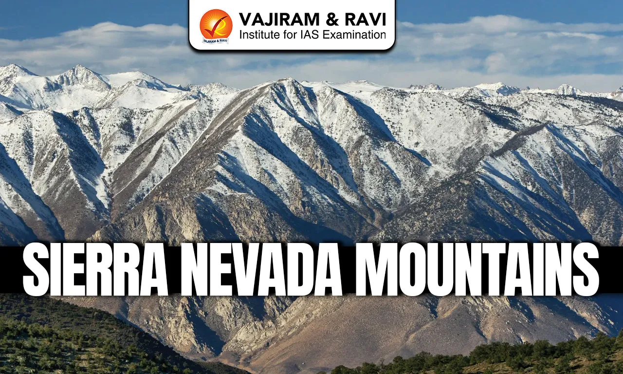
The Sierra Nevada Mountains are a major mountain range in Western North America, mainly located in California. They run from North to South and include some of the highest peaks in the United States, such as Mount Whitney. The range is known for its steep slopes, deep valleys and glaciers and they play a crucial role in climate, rivers and water supply of the region.

Sierra Nevada Mountains

  • Sierra Nevada lies between the Central Valley in the west and the Basin and Range Province in the east, extending from the Mojave Desert to the Cascade Range.
  • The range is famous for its high peaks, scenic landscapes and giant sequoia trees, the largest trees in the world.
  • It is an important source of water, hydroelectric power and was a key region during the California Gold Rush, though human activities like mining and tourism have changed its natural landscape.

Sierra Nevada Mountains Physical Features

Physiography

  • The Sierra Nevada is an asymmetrical mountain range, with its highest peaks and steep slopes on the eastern side.
  • Most peaks are 11,000-14,000 feet high; Mount Whitney (14,494 feet) is the highest peak in the contiguous United States.
  • The northern part of the range is lower, with heights mostly between 7,000 and 9,000 feet.
  • Geologically, the range is mainly made of granite, along with some metamorphic rocks and volcanic rocks, especially in the northern section where it connects with the Cascade Range.

Geology

  • The Sierra Nevada is an uplifted and tilted block of the Earth’s crust, formed due to faulting.
  • A major fault lies on the eastern side, along which the land was pushed upward and tilted westward, making the range asymmetrical.
  • The eastern slope is steep, with deep canyons formed by erosion from wind, rain, ice and frost.
  • The western slope is gentle, where rivers deposit sediments and form large alluvial fans extending into California’s Central Valley.
  • Although uplift began millions of years ago, major uplift occurred in the last 2 million years, giving the range its great height today.

Drainage and Glaciation

  • The western slope of the Sierra Nevada is gentle and has long rivers like the Yuba, American, Merced and Kern, which mostly flow into the Sacramento-San Joaquin river system and finally reach the Pacific Ocean.
  • Most rivers rise in deep valleys carved by glaciers in hard granite rocks.
  • During the Pleistocene period, large glaciers covered the mountain valleys several times and shaped the landscape.
  • These glaciers formed U-shaped valleys, cirques, moraines and many glacial lakes, especially on the western side.
  • Famous features like Yosemite Valley and Lake Tahoe are results of glacial erosion; Lake Tahoe is one of the largest and deepest alpine lakes in the world.

Climate

  • The Sierra Nevada has a mild mountain climate as it lies in the mid-latitudes and is close to the Pacific Ocean, which lowers the extreme temperatures.
  • The range runs northwest to southeast, so moist winds from the Pacific give heavy rainfall and snowfall on the western slopes, while the eastern slopes remain dry due to the rain-shadow effect.
  • Most rainfall occurs from November to April and snowfall increases with height, with deep snow cover on higher northern peaks.
  • In summer, a high-pressure system over the Pacific brings dry weather; when it remains strong for many years, the region may face long droughts.

Flora and Fauna

  • The Sierra Nevada shows distinct vegetation zones based on altitude, from foothill forests to alpine plants above the tree line.
  • Lower and upper slopes have deciduous trees, pines, fir, cedar, and giant sequoias, while subalpine areas support hardy conifers.
  • The eastern slopes are dry, with desert-type vegetation like sagebrush and juniper; chaparral grows on both sides except alpine zones.
  • Wildlife includes black bear, mule deer, mountain lion, and smaller mammals like bobcat, beaver, pika, and marmot, varying with height.

Sierra Nevada Mountains FAQs

Q1: Where are the Sierra Nevada Mountains located?

Ans: They are located in western North America, mainly along the eastern side of California, between the Central Valley and the Basin and Range Province.

Q2: What is the highest peak of the Sierra Nevada Mountains?

Ans: Mount Whitney (14,494 feet) is the highest peak of the Sierra Nevada and the highest in the contiguous United States.

Q3: Why are the Sierra Nevada Mountains called asymmetrical?

Ans: As they have steep slopes and high peaks on the eastern side and gentle slopes on the western side.

Q4: What type of rocks mainly form the Sierra Nevada Mountains?

Ans: The range is mainly made of granite, along with some metamorphic and volcanic rocks, especially in the northern part.

Q5: Which major rivers drain the Sierra Nevada region?

Ans: Rivers like the Yuba, American, Merced, and Kern drain the region, mostly flowing into the Sacramento–San Joaquin river system.

Orinoco River, Origin, Length, Tributaries, Features, Biodiversity

Orinoco River

The Orinoco River is one of South America’s most powerful and scientifically significant river systems, known for its immense water discharge, rich biodiversity and crucial role in shaping northern South America. Flowing mainly through Venezuela and partly along Colombia, the river supports dense rainforests, vast savannas and one of the world’s largest river deltas. Its basin receives heavy rainfall averaging about 2,300 millimetres annually, making the Orinoco a lifeline for ecosystems, transport, livelihoods and regional climate stability across a drainage area of nearly one million square kilometres.

Orinoco River

The Orinoco River stretches about 2,140 kilometres, making it among the longest rivers in South America and the fourth largest globally by water discharge, releasing nearly 39,000 cubic metres per second at its delta. It flows in a broad arc around the Guiana Shield before emptying into the Atlantic Ocean through a vast delta. Around 65% of its basin lies in Venezuela and 35% in Colombia, supporting navigation, trade and settlement.

Also Read: Loire River

Orinoco River Features

The Orinoco River is defined by its enormous discharge, complex course, vast delta, unique hydrological links and strong seasonal flow variations.

  • Origin: It originates at Cerro Delgado Chalbaud in the Sierra Parima at 1,047 metres above sea level.
  • Length: The river flows for about 2,140 kilometres, draining nearly 1,000,000 square kilometres, covering most of Venezuela and large parts of eastern Colombia.
  • Water Discharge: With an average discharge of around 39,000 cubic metres per second at its mouth, it ranks fourth globally by volume, driven by intense tropical rainfall.
  • Course: The river is divided into upper, middle, lower and delta sections, flowing through mountains, rapids, plains and wide alluvial lowlands.
  • Delta Formation: The Delta Amacuro spans roughly 22,500 square kilometres, branching into hundreds of channels and wetlands before reaching the Atlantic Ocean.
  • Seasonal Variation: During the rainy season, the river can expand up to 22 kilometres wide and reach depths of nearly 100 metres, causing widespread flooding.
  • Casiquiare Canal: A rare natural waterway, the Casiquiare links the Orinoco to the Amazon basin via the Rio Negro, forming a unique inter-basin connection.
  • Tributaries: Important tributaries include the Caroní, Apure, Meta, Guaviare, Caura, Ventuari and Arauca, greatly increasing water volume downstream.
  • Navigation: The river is navigable for most of its length, allowing ocean going ships to reach Ciudad Bolívar, about 435 kilometres inland.
  • Infrastructure: Major bridges like the Angostura Bridge and Orinoquia Bridge highlight its economic importance and engineering challenges.

Also Read: Oder River

Orinoco River Biodiversity

The Orinoco basin supports exceptional biodiversity, with thousands of plant and animal species adapted to rivers, forests, savannas and wetlands.

  • Fish Diversity: More than 1,000 fish species are recorded, with nearly 15% endemic, dominated by Characiformes and Siluriformes groups.
  • Iconic Fish Species: Notable species include the black spot piranha, electric eel, cardinal tetra and large catfish like the laulao exceeding 90 kilograms.
  • Reptiles: The critically endangered Orinoco crocodile, reaching over 6 metres in length, is among the rarest reptiles globally, confined to this basin.
  • Aquatic Mammals: The river hosts pink river dolphins, giant river otters and manatees, all dependent on seasonal floods and healthy waterways.
  • Birdlife: Over 1,300 bird species occur in the basin, including scarlet ibis, parrots, bellbirds and migratory wetland species.
  • Terrestrial Mammals: Jaguars, tapirs, capybaras, armadillos, anteaters and several deer species inhabit forests, gallery woodlands and savannas.
  • Plant Diversity: Mangroves dominate the delta, while gallery forests, morichal palm groves, rainforests and grasslands cover the wider basin.
  • Endemic Species: Several mammals and fish, such as the Orinoco four eyed opossum, are found nowhere else in the world.
  • Ecological Productivity: Seasonal flooding deposits nutrient rich sediments, sustaining fisheries, forests and one of South America’s most productive ecosystems.
  • Conservation: Despite being relatively intact, the basin faces threats from mining, deforestation and pollution, making conservation critical for biodiversity survival.

Orinoco River FAQs

Q1: Where does the Orinoco River originate?

Ans: The Orinoco River originates at Cerro Delgado Chalbaud in the Sierra Parima region of southern Venezuela, near the Brazil border.

Q2: Which countries does the Orinoco River flow through?

Ans: The Orinoco River flows mainly through Venezuela and partly along the border and plains of eastern Colombia.

Q3: Why is the Orinoco River hydrologically unique?

Ans: It is uniquely connected to the Amazon River system through the natural Casiquiare Canal, forming a rare river to river linkage.

Q4: What flora and fauna are found in the Orinoco River?

Ans: The river basin supports over 1,000 fish species, rare reptiles like the Orinoco crocodile, river dolphins and extensive wetlands.

Q5: How does seasonal rainfall affect the Orinoco River?

Ans: Heavy tropical rainfall causes extreme seasonal flooding, expanding the river’s width and depth and replenishing soils and ecosystems.

Black Soil, Origin, Formation, Geographical Distribution, Characteristics

Black Soil

Black soil, also known as Regur soil or Black cotton soil, is one of the most important soil types of India. It is especially suitable for cotton cultivation and is mainly found in the Deccan Plateau region.

Black Soil Origin and Formation

  • Black Soil is primarily formed by the weathering of basaltic rocks of the Deccan Trap region which were formed by volcanic eruption  during the Cretaceous period.

Black Soil Geographical Distribution

  • Black soil is the third most common soil in India. It covers nearly 16–18% of India’s total geographical area.
  • Black soil is mainly found over the Deccan Plateau.
  • Major states include Maharashtra, Madhya Pradesh, Gujarat, Telangana, Andhra Pradesh, Karnataka, and Tamil Nadu. It is also found in parts of Chhattisgarh and along the Narmada and Tapi river valleys.

Black Soil Characteristics

  • Colour: Black Soil is dark black in colour due to the presence of organic matter and iron and aluminium. 
  • Texture: Black Soil is fine grained and clayey in nature.
  • High Water Holding Capacity: Black Soil has a very high water holding capacity, making it suitable for rain-fed agriculture in semi- arid regions. Moisture remains available to crops even during dry spells. 
  • Self-Ploughing: Due to high clay content, black soil shrinks and develops deep, wide cracks during hot, dry seasons. These cracks allow for significant aeration and natural mixing of soil particles, effectively "ploughing" itself without human intervention. 
  • Rich in lime (calcium carbonate), iron, magnesium, and alumina. 
  • Poor in nitrogen, phosphorus, and organic matter.
  • Crops: Black soil is famous for cotton farming, but it is also suitable for soybean, groundnut, sunflower, jowar, maize, pulses, sugarcane, pulses, and some fruits. It supports both Kharif and Rabi crops due to moisture retention capacity.

UPSC CSE Previous Year Question (2021) 

Q: The black cotton soil of India has been formed due to the weathering of

  1. Brown forest soil
  2. Fissure volcanic rock
  3. Granite and schist
  4. Shale and limestone

Ans: 2

Black Soil FAQs

Q1: What is another name of black soil?

Ans: Black soil is also known as Regur soil or Black cotton soil.

Q2: From which rock type is black soil formed?

Ans: It is formed from the weathering of basaltic rocks of the Deccan Trap.

Q3: In which region of India is black soil mainly found?

Ans: It is mainly found in the Deccan Plateau region of central and southern India.

Q4: Which is the most important crop grown in black soil?

Ans: Cotton is the most important crop grown in black soil.

Q5: Which nutrients are abundant and which are deficient in black soil?

Ans: Rich in Lime, iron, magnesium, and alumina and Deficient in: Nitrogen, phosphorus, and organic matter.

Oder River, Origin, Tributary, Length, Features, Biodiversity

Oder River

The Oder River is one of the most important transboundary rivers of Central Europe. It plays a major role in the geography, ecology and economy of the region. It flows through the Czech Republic, Poland and Germany and drains into the Baltic Sea system. It supports nearly 16 million people in its catchment. The river has shaped settlement, trade routes, political borders and environmental debates in Europe for centuries, while also facing modern ecological pressures.

Oder River

The Oder River, known as Odra in Polish and Czech. It flows northwest through western Poland, forming a 187 kilometre stretch of the Poland-Germany border, before entering the Szczecin Lagoon and finally the Baltic Sea via the Dziwna, Świna and Peene branches. It is the second longest river of Poland and a crucial inland waterway linking Central Europe to Baltic trade networks.

Also Read: Pearl River

Oder River Features

The Oder River is a long, navigable, international river with complex hydrology, major tributaries, canals and economic importance.

  • Origin: The river arises from Hrubý Jeseník Mountains of the Czech Republic at about 2,100 feet above sea level.
  • Length: The Oder is about 840 kilometres long, with 726 kilometres in Poland.
  • Basin: The basin is of roughly 119,074 square kilometres, nearly 89% within Polish territory.
  • Course: It flows southeast to northwest initially, then turns north after meeting the Lusatian Neisse, finally reaching the Baltic Sea through the Szczecin Lagoon.
  • Tributaries: Key tributaries include the Warta at 808 kilometres, Bóbr at 279 kilometres, Lusatian Neisse at 252 kilometres and Barycz at 139 kilometres.
  • Hydrology: Average discharge varies widely, with middle course flows around 18,820 cubic feet per second and extreme flood peaks exceeding 76,000 cubic feet per second during wet years.
  • Navigation: The river is navigable for about 475 miles annually, supported by canalisation, locks and canals such as the Gliwice Canal, Oder-Spree Canal and Oder-Havel Canal.
  • Cities: Important cities that are situated along the river include Ostrava, Racibórz, Opole, Wrocław, Frankfurt (Oder) and Szczecin, reflecting its role in urban and industrial development.
  • Economic Role: It carries nearly 10% of Szczecin port cargo and links industrial Silesia with Baltic Sea trade, easing pressure on road and rail transport.
  • Physiographic Zones: Upper reaches are mountainous with steep gradients, middle sections flow through wide glacial valleys and lower reaches form lowland channels with lagoons and branches.

Also Read: Kushiyara River

Oder River Biodiversity

The Oder River supports diverse wetlands, fish, birds and mammals, though biodiversity has fluctuated due to pollution and restoration efforts.

  • Wetland Diversity: The basin contains at least 42 wetlands and 15 forest community types, including peat bogs, reed beds, alder forests and floodplain meadows.
  • Fish Species: Common fish include bream, eel, catfish, carp, dace and tench, with habitat diversity supporting both freshwater and brackish water species.
  • Birdlife: Species recorded include red kite, golden oriole, marsh warbler, penduline tit, white tailed eagle, lesser spotted eagle and large breeding crane populations near Szczecin.
  • Mammals: Beavers and otters are increasing, alongside wild boar, roe deer, bats, forest mice, weasels and velvet shrews in riparian habitats.
  • Amphibians and Reptiles: Comb newts, grass frogs, water and grey toads and grass snakes indicate recovering aquatic and semi aquatic ecosystems.
  • Lower Oder Valley: This region hosts endemic flora and fauna, shaped by natural flooding after failed agricultural drainage attempts restored wetland conditions.
  • Protected Areas: Numerous Natura 2000 sites and the Lower Oder Valley International Park protect habitats jointly managed by Poland and Germany.
  • Ecological Recovery Efforts: Reduced nitrogen, phosphorus and organic pollution since the 1990s has improved oxygen levels, aiding gradual biodiversity restoration.

Also Read: Vamsadhara River

Oder River Challenges

The Oder River faces pollution, climate stress, hydrological alteration and cross border management challenges affecting ecosystems and human livelihoods.

  • Industrial and Agricultural Pollution: Centuries of sewage discharge, mining effluents and farm runoff increased nutrient loads, salinity and toxic substances in river waters.
  • 2022 Environmental Disaster: Over 360 tonnes of fish died along 500 kilometres due to toxic blooms of Prymnesium parvum, enabled by high salinity, heat and low flow.
  • Toxic Algal Blooms: Prymnesium parvum, a microscopic golden algae producing gill damaging toxins, thrives in brackish, nutrient rich waters between 10°C and 27°C.
  • Hydromorphological Changes: Canalisation, straightening and construction of about 23 dams disrupted natural flow, sediment transport and fish migration routes.
  • Climate Change Impacts: Rising temperatures, droughts, altered precipitation and sea level rise increase flood risks, storm surges and future algal bloom frequency.
  • 2024 Fish Mortality Event: Hundreds of dead fish reported again raised concerns over recurring toxic contamination and inadequate preventive monitoring systems.
  • Invasive Species Spread: Canals connecting the Oder to other European waterways facilitate movement of exotic flora and fauna, stressing native ecosystems.
  • Governance and Cooperation: The International Commission for the Protection of the Oder coordinates pollution control, flood prevention and ecosystem restoration across three countries.

Oder River FAQs

Q1: Where does the Oder River originate?

Ans: The Oder River originates in the Hrubý Jeseník Mountains of the Czech Republic at an elevation of about 2,100 feet above sea level.

Q2: Which countries does the Oder River flow through?

Ans: The Oder flows through the Czech Republic and Poland and forms a long natural border between Poland and Germany.

Q3: Into which sea does the Oder River drain?

Ans: The Oder River drains into the Baltic Sea through the Szczecin Lagoon and its three outlets: Dziwna, Świna and Peene.

Q4: Why is the Oder River important for transport?

Ans: It is navigable over most of its length and connects industrial regions of Central Europe with Baltic Sea trade routes via canals.

Q5: What caused the major fish deaths in the Oder River in 2022?

Ans: The deaths were caused by toxic algal blooms of Prymnesium parvum, triggered by high salinity, warm temperatures, low water levels and nutrient pollution.

Loire River, Source, Tributaries, Flora and Fauna, Challenges

Loire River

The Loire River is the longest river in France and one of the most geographically and ecologically significant river systems in Western Europe. Stretching across diverse landscapes, it has shaped human settlement, trade, biodiversity and culture for thousands of years. It flows entirely within France and links the Massif Central highlands to the Atlantic Ocean. The river supports agriculture, forests, wetlands and historic towns. Its largely free flowing nature makes it unique among major European rivers. The Loire basin covers more than one-fifth of France’s land area.

Loire River

The Loire River is 1,006 kilometres long, making it the longest river in France and the 171st longest river in the world. It originates at about 1,350 to 1,408 metres above sea level near Mont Gerbier de Jonc in the Cévennes range of the Massif Central. From there, it flows north through central France and then west, finally entering the Atlantic Ocean at the Bay of Biscay near Saint-Nazaire. The river drains an area of about 117,054 square kilometres, yet its average discharge of around 863 cubic metres per second is relatively modest compared to the Rhône.

Also Read: Danube River

Loire River Features

The Loire River displays remarkable physical diversity from source to sea, shaped by geology, climate, tributaries and human interaction.

  • Length: The Loire flows for 1,006 km and drains 117,054 km², covering over 20 percent of France’s land surface.
  • Source: It rises from multiple springs near Mont Gerbier de Jonc at over 1,350 m elevation, initially forming small converging streams.
  • Flow Direction: The river flows northward through Roanne and Nevers, then turns westward at Orléans toward Tours and Nantes.
  • River Zones: It is divided into Upper Loire, Middle Loire and Lower Loire, each with distinct valley width, flow speed and land use.
  • Tributaries: Major tributaries include the Allier at 410 km, Vienne at 372 km, Cher at 367 km and Indre at 287 km.
  • Alluvial Plains: The middle course features broad alluvial plains with sandbanks, islands and braided channels formed by sediment deposition.
  • Discharge: Average discharge is about 350 m³/s at Orléans and nearly 900 m³/s at the river mouth near Saint-Nazaire.
  • Dams: Only a few dams, including Villerest and Grangent, regulate flow, preserving much of the river’s natural dynamics.
  • Estuary Formation: Near Nantes, the river forms a 60 km long tidal estuary with wetlands, mudflats and saline influenced habitats.

Also Read: Bharathapuzha River

Loire River Biodiversity

The Loire River supports one of the richest freshwater ecosystems in France due to its free flowing character and habitat diversity.

  • Phytoplankton Diversity: Over 100 algae species occur, dominated by diatoms and green algae, with highest diversity near Orléans.
  • Fish Species Richness: Around 57 freshwater fish species from 20 families inhabit the basin, including migratory and resident species.
  • Migratory Fish: Atlantic salmon, sea trout, shad, sea lamprey and European eel migrate upstream for spawning.
  • Salmon Decline and Recovery: Atlantic salmon numbers dropped from about 100,000 in the 19th century to below 100 in the 1990s.
  • Restoration: Conservation efforts increased salmon populations to around 500 individuals by 2005 after dam removal and restocking.
  • Endangered Species: Threatened fish include European grayling, burbot and bitterling, sensitive to habitat loss and pollution.
  • Amphibian Habitat: Floodplains and oxbow lakes support frogs, toads, salamanders and newts such as Triturus marmoratus.
  • Bird Diversity: About 164 bird species, nearly 64 percent of France’s nesting birds, use Loire habitats for breeding or migration.
  • Wetland: Lower Loire wetlands provide critical stopover sites for migratory birds along Atlantic flyways.
  • Forest and Riparian Flora: Oak, beech, pine, willow and alder forests stabilize banks and support complex food webs.

Also Read: Tamraparni River

Loire River Challenges

Despite its ecological value, the Loire River faces multiple environmental and human induced pressures.

  • Flood Risk: Seasonal floods, especially in late winter, threaten towns despite historic dike systems built between the 12th and 19th centuries.
  • Low Summer Flows: Discharge can fall below 10 m³/s near Orléans in late summer, stressing aquatic life.
  • Climate Change: Increased drought frequency, as seen in 2022, has dried sections of the river, affecting navigation and ecosystems.
  • Industrial Pressure: Ports, oil refineries and nuclear power plants near the lower Loire impact water quality and thermal balance.
  • Habitat Fragmentation: Past dam construction reduced spawning grounds, especially for salmon and pike.
  • Pollution Sources: Agricultural runoff, urban wastewater and industrial effluents degrade water quality in some stretches.
  • Navigation Modifications: Groynes and embankments alter sediment transport and channel structure in navigable sections.
  • Wetland Loss: Drainage of oxbows and marshes has reduced natural flood buffers and biodiversity hotspots.
  • Conservation Conflicts: Proposals for large dams historically clashed with environmental protection goals.
  • Management Complexity: Balancing flood control, biodiversity conservation, navigation and regional development remains a major challenge.

Loire River FAQs

Q1: Where does the Loire River originate and end?

Ans: It originates near Mont Gerbier de Jonc in the Cévennes range and flows into the Atlantic Ocean at the Bay of Biscay near Saint-Nazaire.

Q2: What is the length of the Loire River?

Ans: The Loire River is 1,006 kilometres long, making it the longest river entirely within France.

Q3: What are the main environmental challenges of the Loire River?

Ans: Key challenges include floods, summer droughts, pollution, habitat loss and climate change impacts on flow and biodiversity.

Q4: Which major cities are located along the Loire River?

Ans: Major cities along the Loire include Orléans, Tours, Blois, Saumur, Angers and Nantes, which developed as trade, cultural and administrative centres.

Q5: Why was the Loire Valley designated as a UNESCO World Heritage Site?

Ans: The Loire Valley was designated a UNESCO World Heritage Site in 2000 for its historic towns, vineyards, châteaux and centuries old interaction between people and the river.

Nile River, Length, Origin, Source, Basin, Dams, Reservoirs

Nile River

The Nile River is the longest river in the world, measuring roughly 6,650 kilometres in length. It flows from south to north through northeastern Africa and drains into the Mediterranean Sea near Alexandria. It has historically been called the “lifeline of Egypt” because it provides water, fertile soil, and resources that have supported agriculture, settlements, and the development of Egyptian civilization for thousands of years.

Nile River Origin and Source

  • The Nile River originates in Burundi, south of the equator, and flows northward through northeastern Africa. 
  • The Nile River does not originate from a single source. It is formed by the confluence of two major river systems, namely the White Nile and the Blue Nile. The White Nile and Blue Nile meet at Khartoum, Sudan, forming the main Nile that flows north through Sudan and Egypt. From there, the river forms a delta and spreads into multiple channels before reaching the Mediterranean Sea.

White Nile 

  • The White Nile is considered the primary source river of the Nile because it provides a continuous, year-round flow. Rainfall in the equatorial region ensures that the White Nile provides a steady supply of water even during the dry season. 
  • It originates from Lake Victoria, which lies within Tanzania, Uganda, and Kenya. 
  • Lake Victoria is fed by several rivers, the most important being the Kagera River, which is often regarded as the ultimate headstream of the White Nile. The Kagera River originates from the highlands of Rwanda and Burundi.
  • From Lake Victoria, the river emerges as the Victoria Nile, flowing through Uganda, passing through Lake Kyoga and Lake Albert, before entering South Sudan, where it is known as the White Nile.

Blue Nile

  • The Blue Nile originates from Lake Tana in Ethiopia and flows westward into Sudan where it joins the White Nile at Khartoum.
  • The river flows from Lake Tana through deep gorges in Ethiopia before entering Sudan.
  • Despite being shorter than the White Nile, the Blue Nile contributes nearly 60–70% of the Nile’s total water volume and most of its fertile silt.

The Atbara River, another important tributary, also originates in the Ethiopian Highlands. It is a seasonal river and contributes water mainly during the rainy season, enhancing the floodwaters of the Nile.

Read about: Tigris River

Nile River Basin 

  • The Nile River Basin is the area drained by the Nile and its tributaries.
  • The Nile Basin spans 11 countries: Burundi, Rwanda, Tanzania, Uganda, Kenya, Democratic Republic of the Congo, South Sudan, Sudan, Ethiopia, Eritrea, and Egypt.
  • The basin covers about 3.4 million km², making it one of the largest river basins in the world.
  • It includes diverse landscapes: lakes, swamps, floodplains, deserts, and highlands.
  • The basin supports agriculture, fishing, drinking water, hydroelectric power, and transportation.

The Nile River is not “owned” by any single country. It is an international river shared by 11 countries in its basin. 

Nile Delta 

  • The Nile River forms a large, fan-shaped arcuate delta in northern Egypt.
  • The delta was formed by the continuous deposition of fine alluvial sediments carried by the Nile, mainly from the Ethiopian Highlands and parts of the Central African plateau. As a result, it became one of the most fertile regions in the world and developed into the agricultural heartland of Egypt, producing crops such as wheat, rice, cotton, sugarcane, and vegetables, and earning the title of the “Granary of Egypt.”
  • The Nile Delta supports one of the highest population densities in Africa. About 95% of Egypt’s population lives on only 3–4% of its land area, mainly along the Nile. Major urban centers such as Alexandria, Mansoura, Tanta, and the outskirts of Cairo are located within or at the margins of the delta. 
  • Ecologically, the Nile Delta contains important wetlands and lagoons such as Lake Manzala and Lake Burullus, which support fisheries, migratory birds, and diverse aquatic ecosystems.

Read about: Phalgu River

Nile River Dams and Reservoirs

The Nile River has several major dams and reservoirs constructed mainly for flood control, irrigation, hydroelectric power generation etc. Major dams are listed below: 

  • Aswan High Dam, located near Aswan in Southern Egypt, is the most important dam. It created Lake Nasser, one of the largest artificial reservoirs in the world.
  • Aswan Low Dam in Egypt, located downstream of the High Dam. It is the first major dam constructed across the Nile.
  • Merowe Dam, located on the Nile in northern Sudan.
  • Roseires Dam, located on the Blue Nile near the Ethiopian border.
  • Sennar Dam in Sudan
  • Grand Ethiopian Renaissance Dam (GERD), located on Blue Nile in northwestern Ethiopia. It is Africa’s largest hydroelectric project. It has become a major source of water-sharing tensions among Ethiopia, Egypt, and Sudan.

Owen Falls Dam or Nalubaale Dam, located in Uganda, at the outlet of lake Victoria.

Nile River FAQs

Q1: Which is the longest river in the world?

Ans: The Nile River is traditionally considered the longest river in the world, with an approximate length of 6,650 km.

Q2: In which direction does the Nile flow?

Ans: The Nile flows from south to north, originating in equatorial and Ethiopian highlands and emptying into the Mediterranean Sea in northern Egypt.

Q3: Into which sea does the Nile drain?

Ans: The Nile drains into the Mediterranean Sea through a large delta in northern Egypt.

Q4: Which are the two main tributaries of the Nile?

Ans: The two major tributaries are: White Nile and Blue Line.

Q5: How many countries are part of the Nile Basin?

Ans: The Nile Basin spans 11 countries:Burundi, Rwanda, Tanzania, Uganda, Kenya, DR Congo, South Sudan, Sudan, Ethiopia, Eritrea, and Egypt.

Danube River, Origin, Length, Delta, Features, Biodiversity

Danube River

The Danube River is the second longest river of Europe after the Volga. It stretches about 2,850 km from the Black Forest of Germany to the Black Sea. It has shaped human settlement, trade routes and political boundaries of Central and Southeastern Europe for over two millennia. Once it  formed the northern frontier of the Roman Empire, the Danube today connects ten countries and supports nearly 83 million people across its vast drainage basin, making it one of the most internationally significant rivers.

Danube River

The Danube originates in Donaueschingen, Germany, at the confluence of the Brigach and Breg streams. The Breg is considered the longest headstream. It flows southeast through or along Germany, Austria, Slovakia, Hungary, Croatia, Serbia, Romania, Bulgaria, Moldova and Ukraine before forming the Danube Delta and entering the Black Sea. Four national capitals: Vienna, Bratislava, Budapest and Belgrade lie on its banks.

Also Read: Tigris River

Danube River Features

The Danube is a complex international river system with major geographical, economic and historical importance across Europe. The key features of the river has been highlighted below:

  • Length: The Danube flows approximately 2,850 km. 
  • Course: It begins in Germany’s Black Forest and ends in the Black Sea, crossing diverse landscapes including alpine foothills, plains, gorges and wetlands across Central and Eastern Europe.
  • Tributary: The Danube is fed by major tributaries like the Inn, Drava, Sava, Tisza, Prut and Siret. Many tributaries are navigable and drain large parts of Central and Eastern Europe, enhancing the river’s hydrological strength.
  • Danube Delta: At its mouth, the Danube splits into three main distributaries forming the Delta. This delta is the largest river delta in the European Union and among the best preserved in the world.
  • International River: The Danube passes through or forms borders of ten countries, more than any other river globally. Its drainage basin also extends into nine additional countries, highlighting its role as a shared transboundary water resource requiring international cooperation.
  • Drainage Basin: Covering about 801,463 to 817,000 km², the Danube basin supports around 83 million people. The basin’s highest point is Piz Bernina at 4,049 m, while its lowest point lies at sea level in the Danube Delta.
  • Navigability: Nearly 2,415 km of the Danube is navigable. 
  • Transport: Through the Rhine-Main-Danube Canal, it connects the North Sea at Rotterdam to the Black Sea at Sulina, forming a 3,500 km trans-European inland waterway.
  • Economic Importance: The Danube serves as a major route for transporting bulk goods, with cargo volumes reaching about 100 million tonnes annually in the late 20th century. It supports ports like Galați and Brăila and facilitates regional trade and tourism.
  • Hydropower: The river hosts major hydropower projects, including Iron Gate I and II between Serbia and Romania. It is also a crucial source of drinking water, directly or indirectly supplying about 20 million people along its course.
  • Historical Significance: Historically, the Danube marked the Roman Empire’s frontier and later became a contested boundary among empires such as the Ottoman, Habsburg and Russian. It has witnessed major events from Roman conquests to modern European integration.

Also Read: Pearl River

Danube River Biodiversity

The Danube supports one of Europe’s richest freshwater ecosystems, hosting diverse species across its river, floodplains and delta as highlighted below:

  • Fish Diversity: The Danube basin supports around 60 fish species in its upper stretches and nearly double in the lower basin. Species include pike, zander, huchen, wels catfish, tench, burbot, carp, trout and salmon.
  • Sturgeon Species: The river historically supported six sturgeon species, including beluga, sterlet and Russian sturgeon. These ancient fish, valued for caviar, are now critically threatened due to dams, pollution and disrupted migration routes.
  • Danube Delta Ecosystem: The Danube Delta covers about 4,152 km², expanding to over 5,165 km² including lagoon systems. It contains marshes, lakes and reed beds that support 45 freshwater fish species and vast aquatic life.
  • Avifauna Species: Over 300 bird species inhabit or migrate through the Danube Delta, including pelicans and the endangered pygmy cormorant. Its wetlands are among Europe’s most important migratory bird resting and breeding areas.
  • Wetland: Historically, the Danube featured extensive floodplains and wetlands. However, over 80% of the river has been regulated, leading to major habitat loss and decline in species like beavers and black poplar trees.
  • Euryhaline Species: In the lower Danube and delta, species tolerant to both freshwater and saltwater, such as European seabass, mullet and eel, thrive due to the river’s gradual mixing with Black Sea waters.
  • Protected Areas: Numerous protected zones exist along the Danube, including Iron Gates Natural Park and the Danube Delta Biosphere Reserve. These areas aim to conserve habitats while balancing navigation, energy production and human use.
  • Environmental Management: The International Commission for the Protection of the Danube River, established in 1998. It coordinates conservation across 14 countries and the European Union by promoting sustainable water management and biodiversity protection.
  • Ecological Challenges: Pollution, dam construction and river regulation have reduced natural sediment flow and fish migration. Ongoing restoration efforts focus on reconnecting floodplains, improving water quality and preserving remaining biodiversity hotspots.

Danube River FAQs

Q1: What is the origin of the Danube River?

Ans: The Danube originates in the Black Forest of Germany at Donaueschingen and flows into the Black Sea through the Danube Delta in Romania and Ukraine.

Q2: Which major capitals are located on the Danube River?

Ans: Four national capitals lie on the Danube: Vienna, Bratislava, Budapest and Belgrade, making it the river with the most capital cities in the world.

Q3: What is the length of the Danube River?

Ans: The Danube River is approximately 2,860 km long, making it the second longest river in Europe after the Volga.

Q4: How many countries does the Danube flow through or border?

Ans: The Danube flows through or forms borders of 10 countries: Germany, Austria, Slovakia, Hungary, Croatia, Serbia, Romania, Bulgaria, Moldova and Ukraine.

Q5: What is the international body managing the Danube River?

Ans: The International Commission for the Protection of the Danube River (ICPDR), established in 1998, coordinates sustainable water management and pollution control among Danube Basin countries.

Enquire Now