Erosional Landforms are small to medium sized physical features of the Earth’s surface created through long term geomorphic processes. When several related landforms combine, they form extensive landscapes representing large surface tracts of the Earth. Each landform has distinct physical characteristics such as shape, size, structure, material composition, and elevation. These features develop gradually due to slow acting geomorphic processes such as erosion, weathering, transportation, and deposition, operating through natural agents like rivers, wind, waves, glaciers, and groundwater over geological time scales.
Erosional Landforms
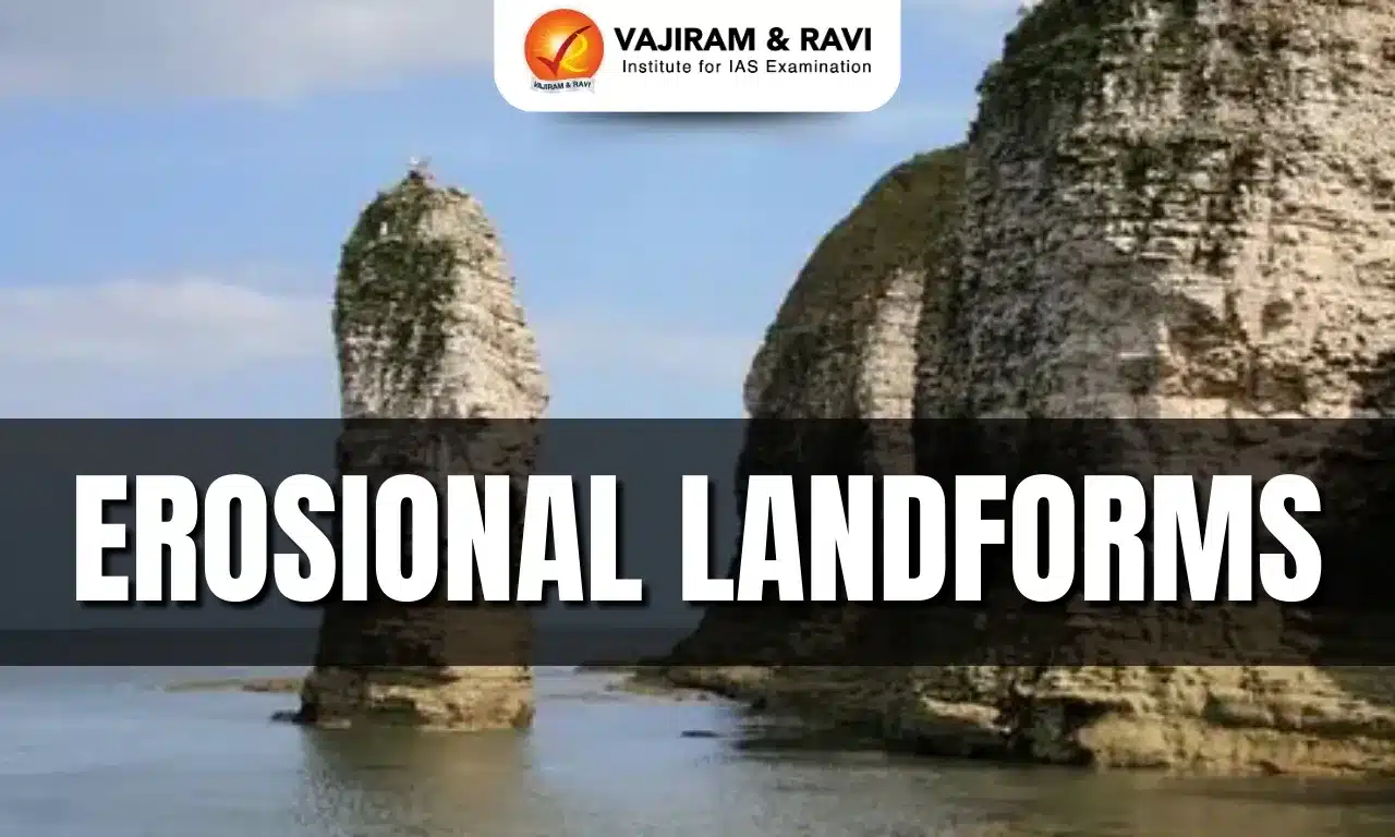
Erosional landforms are surface features shaped primarily by the removal of soil and rock through erosional agents like running water, wind, waves, and ice. These landforms develop where erosion dominates over deposition, often in regions of high relief, steep gradients, strong winds, or turbulent water flow. Examples include valleys, gorges, potholes, caves, arches, stacks, pedestals, yardangs, and deflation basins. Such landforms reflect the intensity, direction, duration, and energy of erosional processes acting upon different rock structures and climatic conditions.
Erosional Landforms Features
Erosional landforms display clear physical traits shaped by continuous removal of material under specific geomorphic controls.
- Structural Control: Shape depends on rock hardness, bedding planes, and joint patterns.
- Agent Dominance: Running water, wind, and waves determine landform geometry.
- Gradient Influence: Steeper slopes enhance vertical erosion intensity.
- Climatic Role: Arid and humid climates produce distinct erosional signatures.
- Energy Dependency: High kinetic energy accelerates erosional efficiency.
- Time Scale: Formation requires thousands to millions of years.
- Surface Texture: Abrasion produces polished, grooved, or pitted surfaces.
- Directional Alignment: Wind landforms align parallel to prevailing wind direction.


Erosional Landforms Formation
Erosional landforms form through sustained interaction between geomorphic agents and Earth materials under varying environmental conditions.
- Fluvial Erosion: Vertical and lateral river erosion sculpts valleys and terraces.
- Aeolian Erosion: Wind abrasion shapes desert landforms like yardangs.
- Hydraulic Action: Force of moving water dislodges rock fragments.
- Abrasion Process: Rock particles grind surfaces during transport.
- Deflation Mechanism: Wind removes fine sediments forming depressions.
- Differential Erosion: Softer rocks erode faster than harder layers.
- Tectonic Influence: Uplift rejuvenates river erosion intensity.
- Climatic Variation: Rainfall and aridity regulate erosional dominance.
Erosional Landforms Classification
Erosional landforms are classified based on the dominant geomorphic agent responsible for their formation.
- Fluvial Landforms: Created by running water erosion.
- Aeolian Landforms: Formed by wind erosion in arid regions.
- Marine or Coastal Landforms: Shaped by wave action along coastlines.
- Glacial Landforms: Result from ice erosion in cold regions.
- Subaerial Landforms: Produced by weathering and mass wasting.
- Structural Landforms: Controlled by rock structure and resistance.
Erosional Landforms Examples
Examples illustrate how different agents carve distinct erosional features across landscapes.
- Valleys: Deepened channels evolving from rills and gullies.
- Gorges: Narrow, deep valleys with steep vertical sides.
- Canyons: Step sided valleys wider at top than base.
- Potholes: Cylindrical depressions drilled into riverbeds.
- Plunge Pools: Deep hollows at waterfall bases.
- Incised Meanders: Deepened river bends cut into bedrock.
- River Terraces: Elevated remnants of former floodplains.
- Pedestal Rocks: Wind eroded mushroom shaped rock structures.
- Ventifacts: Wind polished, grooved desert rock surfaces.
- Zeugen: Table like rock forms protected by hard caps.
- Yardangs: Streamlined ridges aligned with wind direction.
- Stone Lattice: Net like rock formations after soft rock removal.
- Driekanter: Three faced rocks shaped by multidirectional winds.
- Wind Windows: Openings carved by sustained wind abrasion.
- Wind Bridges: Arch shaped features formed from enlarged windows.
- Demoiselle: Pillar like hard rock remnants after soft erosion.
- Lag Deposits: Heavy stones left after fine material removal.
- Deflation Basins: Depressions formed by persistent wind deflation.
- Oasis: Water exposed zones due to deflation erosion.
- Needles: Sharp rock spires after soft rock erosion.
- Inselbergs: Isolated resistant rock hills on plains.
- Pediplains: Broad plains formed by extensive erosion.
Also Read: Landforms of the Earth
Erosional Landforms Significance
Erosional landforms provide crucial insights into Earth surface processes, environmental history, and human environment interactions.
- Geomorphic Indicators: Reveal intensity and direction of erosion.
- Paleoclimatic Evidence: Preserve records of past climates.
- Hydrological Understanding: Explain river behavior and valley evolution.
- Resource Assessment: Guide groundwater and mineral exploration.
- Hazard Identification: Indicate erosion prone and unstable regions.
- Landscape Evolution: Demonstrate long term surface modification.
- Ecological Influence: Control soil depth and vegetation patterns.
- Human Settlement: Affect agriculture, transport, and habitation.
![]() Last updated on July, 2026
Last updated on July, 2026
→ UPSC Prelims Result 2026 is now out.
→ UPSC IFoS Prelims Result 2026 is now out.
→ Enroll in Vajiram & Ravi’s UPSC Mains Test Series 2026 for structured answer writing practice, expert evaluation, and exam-oriented feedback.
→ Join Vajiram & Ravi’s UPSC Mentorship Program 2026 for personalized guidance, strategy planning, and one-to-one support from experienced mentors.
→ Join Vajiram & Ravi’s UPSC Mentorship Program 2027 for personalized guidance, strategy planning, and one-to-one support from experienced mentors.
→ UPSC Prelims Provisional Answer Key 2026 out for GS Paper 1 and CSAT.
→ UPSC Prelims Question Paper 2026 Out, Download GS Paper 1 PDF conducted on 24th May 2026.
→ UPSC Mains 2026 will be conducted from 21st August 2026 onwards, and UPSC Prelims 2027 will be held on 23rd May 2027.
→ UPSC Final Result 2025 is now out.
→ UPSC has released UPSC Toppers List 2025 with the Civil Services final result on its official website.
→ Anuj Agnihotri secured AIR 1 in the UPSC Civil Services Examination 2025.
→ UPSC Notification 2026 & UPSC IFoS Notification 2026 is now out on the official website at upsconline.nic.in.
→ UPSC Calendar 2027 has been released.
→ Check out the latest UPSC Syllabus 2026 here.
→ The UPSC Selection Process is of 3 stages-Prelims, Mains and Interview.
→ Shakti Dubey secures AIR 1 in UPSC CSE Exam 2024.
→ Also check Best UPSC Coaching in India
Erosional Landforms FAQs
Q1. What are Erosional Landforms?+
Q2. Which agents form Erosional Landforms?+
Q3. Where are river erosional landforms found?+
Q4. Why are desert erosional landforms unique?+
Q5. Why are Erosional Landforms important?+
Tags: erosional landforms