The Ganga River System is also known as the Ganges River System, an extensive and intricate network of rivers, tributaries, distributaries, and wetlands covering multiple states in northern India and parts of Bangladesh. The Ganga River is already considered sacred in Hinduism and holds immense religious importance. It is one of the most significant river systems in the world, supporting a vast population and influencing the cultural, religious, and economic landscape of the region. The Ganga originates in the Himalayas and flows through the fertile Indo-Gangetic Plain. It eventually drains into the Bay of Bengal, forming the Ganges-Brahmaputra Delta, one of the largest river deltas in the world.
Ganga River System
The Ganga River is one of the major rivers of the Himalayan drainage system and the most sacred river in India. Flowing through northern and eastern India, it forms the largest river basin of the country, supporting diverse flora, fauna, and human settlements.
Key facts include:
- It stretches over 2,500 km, making it one of Asia’s longest rivers.
- It forms a complex network of Himalayan and Peninsular tributaries.
- It sustains numerous cities, farmlands, and industries across its basin.
- It holds immense spiritual significance in Hindu traditions, rituals, and pilgrimages.
Ganga River System Origin
The Ganga originates as the Bhagirathi River from the Gangotri Glacier at Gaumukh in Uttarakhand at an elevation of 3,892 m. After merging with the Alaknanda River at Devprayag, the stream is officially named Ganga.
Flowing for nearly 2,525 km, the Ganga passes through the states of Uttarakhand, Uttar Pradesh, Bihar, Jharkhand, and West Bengal, touching the lives of millions. It forms one of the world’s most densely populated basins, accounting for 26.4% of India’s geographical area and supporting nearly 50% of India’s population.
- Origin: Gaumukh (Gangotri Glacier), Uttarakhand
- Source Stream: Bhagirathi
- Total Length: ~2,525 km
- Major States: Uttarakhand → UP → Bihar → Jharkhand → West Bengal
- Final Drainage: Bay of Bengal


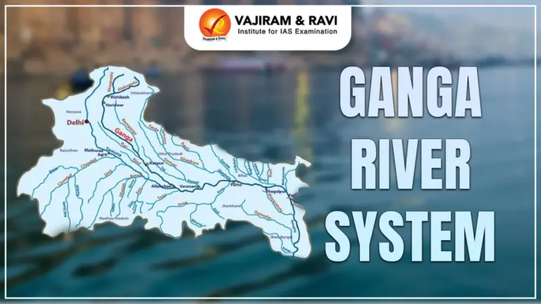
Ganga River System Map
The Ganga River System is the largest and most sacred river network in India, playing a central role in the country’s cultural, spiritual, and ecological landscape. A Ganga River System Map illustrates the origin, major tributaries, and extensive drainage basin of the Ganga River, which spans multiple states across northern and eastern India before emptying into the Bay of Bengal.
Course of the Ganga River System
The course of Ganga can be divided into three major sections: Upper Course, Middle Course, and Lower Course, shaped by Himalayan terrain, alluvial plains, and deltaic regions.
Upper Course (Himalayan Region)
This part features steep gradients, rapids, and narrow gorges.
- Bhagirathi meets Alaknanda at Devprayag → River named Ganga
- Enters plains at Haridwar
- Barrages at Haridwar, Bijnor, and Narora divert water to Upper, Madhya, and Lower Ganga Canals
Middle Course (Indo-Gangetic Plains)
From Haridwar to Bihar, the river becomes wider and supports dense agricultural activity.
- Joined by major tributaries: Ramganga, Yamuna, Gomti, Ghaghara, Gandak, Kosi
- Plains provide extremely fertile alluvial soil
- River meanders widely due to low gradient
Lower Course (Bengal Region)
The river slows down and splits into distributaries forming the world’s largest delta.
- Farakka Barrage regulates flow
- Ganga splits into Bhagirathi-Hooghly (right) and Padma (left)
- Padma enters Bangladesh and joins Brahmaputra & Meghna
- Dense mangrove forests (Sundarbans) formed by tidal influence
Ganga River System Tributaries
The Ganga River System is fed by various tributaries and sub-tributaries, which are categorized into right-bank and left-bank tributaries depending on their position relative to the main source (the Ganga).
Ganga River System Right Bank Tributaries
The Ganga River System is one of the most extensive and sacred river systems in India. It originates from the Gangotri Glacier in Uttarakhand and flows through the northern plains, nourishing millions of lives. The river receives several right bank tributaries, mainly from the southern side of its flow. The major right-bank tributaries joining the Ganga River include:
- Yamuna River
- Tons (Tamsa) River
- Son (Sone) River
- Punpun River
- Chandan River
- Phalgu (Niranjana) River
- Kiul River
- Karamnasa River
1. Yamuna River
The Yamuna is the largest and most important right-bank tributary of the Ganga. It originates from the Yamunotri Glacier in Uttarakhand and flows through major urban and agricultural centers.
- Originates at 6,387 meters in the Himalayas.
- Passes through Haryana, Delhi, and Uttar Pradesh.
- Major tributaries: Chambal, Betwa, Ken, Hindon.
- Joins the Ganga at Allahabad (Prayagraj) at the Triveni Sangam.
Importance
- Essential for irrigation in the Yamuna–Ganga Doab.
- Provides water to Delhi and surrounding regions.
- Associated with ancient Indian civilization and heritage.
2. Tons (Tamsa) River
The Tons River is an important right-bank tributary flowing through central India.
- Originates in the Kaimur Range, Madhya Pradesh.
- Known for waterfalls like the Chachai Falls.
- Flows through Madhya Pradesh and Uttar Pradesh.
Importance
- Supports local irrigation and agriculture.
- Carries seasonal monsoon flows essential for eastern UP plains.
3. Son (Sone) River
The Son River is a major right-bank tributary with a large basin area.
- Originates from the Amarkantak Plateau, Madhya Pradesh.
- Longest right-bank tributary after the Yamuna.
- Flows through MP, UP, Jharkhand, Bihar.
- Known for the Indrapuri Barrage in Bihar.
Importance
- Major irrigation projects for Bihar and UP.
- Alluvial plains formed by the river are agriculturally fertile.
4. Punpun River
The Punpun River flows parallel to the Ganga and drains eastern Bihar.
- Originates in Palamu Hills of Jharkhand.
- Flows through Gaya, Patna.
- Joins the Ganga near Fatuha in Bihar.
Importance
- Crucial for local farming in Bihar’s plains.
- Religious mention in the Puranas as a sacred river.
5. Chandan River
A small right-bank tributary located in Bihar and Jharkhand.
- Originates in Jharkhand’s hills.
- Flows into Bihar’s plains and merges with the Ganga.
Importance
- Supports agriculture and groundwater recharge.
- Plays a role in small-scale irrigation.
6. Phalgu (Niranjana) River
The Phalgu River is historically significant due to its association with Bodh Gaya.
- Formed by the merging of Niranjana and Mohana rivers.
- Flows through Gaya in Bihar.
- Eventually drains into the Punpun River.
Importance
- Considered sacred by Hindus and Buddhists.
- Important for religious rituals in Gaya (Pind Daan).
Ganga River System Left Bank Tributaries
The Ganga River System, one of the largest in the world, receives numerous tributaries that join it from the northern Himalayan side. These are known as the left-bank tributaries. They originate mainly in the Himalayas, making them perennial rivers with high discharge, rich sediments, and strong ecological influence. The major left-bank tributaries of the Ganga include:
- Ramganga River
- Gomti River
- Ghaghara (Karnali) River
- Gandak River
- Kosi River
- Mahananda River
1. Ramganga River
The Ramganga River originates in the Doodhatoli Range of Uttarakhand and flows through the Jim Corbett National Park before entering the plains. It contributes significantly to irrigation and water supply in western Uttar Pradesh. The river joins the Ganga near Kannauj, increasing its discharge.
- Origin: Doodhatoli Hills, Uttarakhand
- Passes through Corbett National Park
- Joins Ganga near Kannauj
2. Gomti River
The Gomti River originates from Gomat Taal in Pilibhit and flows entirely through the plains of Uttar Pradesh. It passes through major cities like Lucknow and Sultanpur, serving as an important water source. The river meets the Ganga at Ghazipur.
- Origin: Gomat Taal, Pilibhit (UP)
- Major cities: Lucknow, Sultanpur, Jaunpur
- Joins Ganga at Ghazipur
3. Ghaghara (Karnali) River
The Ghaghara River rises in the Tibetan Plateau near Lake Mansarovar and flows through Nepal before entering India. It is one of the largest and most powerful tributaries, bringing heavy sediments and causing floods. The river joins the Ganga at Chhapra in Bihar.
- Origin: Mapchachungo Glacier, Tibet
- Known as Karnali in Nepal
- Joins Ganga at Chhapra (Bihar)
4. Gandak River
The Gandak River originates in the Himalayas of Nepal from the Nhubine Himal Glacier. It flows southward through deep valleys and brings nutrient-rich alluvium to Bihar. The river meets the Ganga near Patna.
- Origin: Nhubine Himal Glacier (Nepal)
- Known as Kali Gandaki/Narayani in Nepal
- Joins Ganga near Patna
5. Kosi River
The Kosi River originates in Tibet and enters India after flowing through eastern Nepal. Known as the “Sorrow of Bihar,” it frequently shifts its course due to heavy sediment load. The river merges with the Ganga at Kursela in Bihar.
- Origin: Tibet (Saptakoshi system)
- Causes widespread floods in Bihar
- Joins Ganga at Kursela
6. Mahananda River
The Mahananda River rises in the Darjeeling Hills and flows through Bihar and West Bengal before entering Bangladesh. It is the easternmost major tributary of the Ganga and influences the hydrology of North Bengal. The river finally joins the Ganga near Godagari.
- Origin: Darjeeling Hills (WB)
- Flows through Bihar & North Bengal
- Joins Ganga near Godagari (Bangladesh)
Ganga River System Cities
The Ganga River flows through several historically, culturally, and economically significant cities in India. These cities have flourished along the river due to fertile lands, trade routes, and religious importance. Many of them, like Haridwar, Varanasi, and Kolkata, serve as major pilgrimage destinations and urban centers. Here is the list of Major Cities located on the bank of Ganga River.
- Srinagar (Uttarakhand) – Known for its ancient temples and scenic Himalayan surroundings.
- Rishikesh (Uttarakhand) – Global hub of yoga and spirituality; gateway to the Himalayas.
- Haridwar (Uttarakhand) – One of the holiest Hindu cities; site of Kumbh Mela and ritual bathing ghats.
- Roorkee (Uttarakhand) – Known for IIT Roorkee and colonial-era canal systems.
- Bijnor (Uttar Pradesh) – A significant agricultural and sugarcane belt along the Ganga.
- Narora (Uttar Pradesh) – Home to Narora Atomic Power Station and Ganga barrage.
- Kannauj (Uttar Pradesh) – Famous for attar (perfume), ancient trade center on Ganga bank.
- Kanpur (Uttar Pradesh) – Major industrial city known for leather, textiles, and IIT Kanpur.
- Prayagraj (Uttar Pradesh) – Site of the Triveni Sangam; hosts the world-famous Kumbh Mela.
- Varanasi (Uttar Pradesh) – One of the world’s oldest cities; a major cultural, spiritual, and educational hub.
- Mirzapur (Uttar Pradesh) – Known for carpets, handicrafts, and its scenic ghats.
- Patna (Bihar) – One of India’s oldest continuously inhabited cities; political and cultural hub.
- Bhagalpur (Bihar) – Known for silk production and Vikramshila ruins.
- Behrampore (West Bengal) – Important town in Murshidabad district along the river.
- Serampore (West Bengal) – Known for colonial heritage and educational institutions.
- Howrah (West Bengal) – Industrial hub; connected to Kolkata by the iconic Howrah Bridge.
- Kolkata (West Bengal) – Major metropolitan city; cultural capital of India and major port city on the Hooghly (Ganga distributary).
Dams on the Ganga River System
The Ganga River System contains several major dams and barrages that play a vital role in hydropower generation, irrigation, flood control, and water management across northern India. These structures support agriculture, drinking water supply, and regional development in Uttarakhand, Uttar Pradesh, Bihar, West Bengal, and adjoining states.
| Dam / Project | River | Location | State | Purpose / Key Features |
|---|---|---|---|---|
| Tehri Dam | Bhagirathi (Ganga headstream) | Tehri | Uttarakhand | 2,400 MW hydropower; irrigation, drinking water; one of the world’s tallest dams |
| Koteshwar Dam | Bhagirathi | Koteshwar | Uttarakhand | Acts as balancing reservoir for Tehri Dam; hydropower |
| Maneri Bhali I & II | Bhagirathi | Uttarkashi | Uttarakhand | Hydroelectric generation: 90 MW (Stage I) + 304 MW (Stage II) |
| Ramganga Dam (Kalagarh Dam) | Ramganga | Kalagarh | Uttarakhand | Multipurpose: irrigation, hydropower, flood control; located near Corbett NP |
| Narora Barrage | Ganga | Bulandshahr | Uttar Pradesh | Supplies water for irrigation; regulates flow near Narora Atomic Power Station |
| Kanpur Barrage | Ganga | Kanpur | Uttar Pradesh | Ensures urban water supply & irrigation regulation |
| Farakka Barrage | Ganga | Murshidabad | West Bengal | 2304 m long; diverts water into Hooghly River to maintain Kolkata Port |
| Gandak Barrage / Project | Gandak | Valmikinagar | Bihar | Indo–Nepal project for irrigation, flood control & hydropower |
| Kosi Project (Kosi Barrage) | Kosi | Birpur | Bihar | Major flood control & irrigation system; Indo–Nepal collaboration |
| Rihand Dam | Rihand (tributary of Son) | Pipri, Sonebhadra | Uttar Pradesh | India’s largest reservoir (Govind Ballabh Pant Sagar); hydropower + irrigation |
| Bansagar Dam | Son | Shahdol | Madhya Pradesh | Joint MP–UP–Bihar irrigation project; hydropower generation |
| Matatila Dam | Betwa (Yamuna tributary) | Lalitpur | Uttar Pradesh | Hydropower, irrigation, regional water supply |
| Chambal Project (Gandhi Sagar, Rana Pratap Sagar & Jawahar Sagar Dams) | Chambal (Yamuna tributary) | MP–Rajasthan | Multipurpose hydropower & irrigation system across three major dams | |
| Damodar Valley Project | Damodar | Jharkhand & West Bengal | Flood control, hydropower, irrigation; India’s first multipurpose river valley project | |
| Durgawati Dam | Durgawati (Karmanasa tributary) | Kaimur | Bihar | Under construction; drinking water + irrigation supply |
Ganga-Brahmaputra Delta
Before merging into the Bay of Bengal, the Ganga and Brahmaputra together form the world’s largest delta, situated between the Bhagirathi-Hooghly and the Padma-Meghna rivers. The coastline of this delta features a highly indented and complex landscape. Comprising a network of distributaries and islands, the region is covered by dense mangrove forests. A significant portion of the Ganga-Brahmaputra Delta consists of low-lying swamps that frequently cause flooding by seawater during high tides.
Government Initiatives for Cleaning the Ganga River
The Ganga River is not only vital for India’s ecology and economy but also holds immense cultural and spiritual significance. Over the years, pollution from industrial, domestic, and agricultural sources has severely impacted its water quality. To restore and maintain the health of the river, the Government of India has launched several initiatives aimed at cleaning, conserving, and rejuvenating the Ganga River and its tributaries.
1. Namami Gange Programme (2014)
- Launched in 2014 by the Ministry of Jal Shakti.
- Objectives: Sewage treatment, riverfront development, industrial effluent control, afforestation along riverbanks.
- Integrated mission with a budget of over ₹20,000 crore for cleaning the Ganga and its tributaries.
2. Ganga Action Plan (GAP I & II)
- GAP-I (1986–2000): First major effort to control pollution in major cities along the Ganga.
- GAP-II (1993–2000): Focused on additional towns and river stretches.
- Key measures included sewage treatment plants (STPs), public awareness campaigns, and industrial waste control.
3. National Ganga River Basin Authority (NGRBA)
- Established in 2009 under the Ministry of Environment & Forests.
- Objective: Coordinated management and pollution control of the Ganga basin.
- Responsible for implementing policies and monitoring water quality across multiple states.
4. River Surface Cleaning Initiatives
- Deployment of floating trash skimmers and manual cleaning drives.
- Focus on plastic, industrial debris, and solid waste removal from riverbanks and ghats.
5. Afforestation and Biodiversity Programs
- Plantation of trees along riverbanks to reduce soil erosion.
- Protection of aquatic species like the Ganges river dolphin and Gharial.
Economic Importance of the Ganga River System
The Ganga River is one of India’s most economically significant rivers, supporting agriculture, industry, fisheries, tourism, and inland navigation. Its fertile plains, abundant water supply, and navigable stretches make it a backbone for regional livelihoods and contribute substantially to the national economy.
- The Ganga River supports irrigation across Uttar Pradesh, Bihar, Jharkhand, and West Bengal, enabling cultivation of rice, wheat, sugarcane, and other crops.
- Its fertile alluvial plains contribute to high agricultural productivity and food security in northern India.
- The river provides habitat for freshwater fish and supports livelihoods of fishermen along its banks.
- It supplies water for industries in cities like Kanpur, Varanasi, and Kolkata, including textiles, leather, paper, and chemical sectors.
- Navigable stretches of the Ganga form part of National Waterway-1, facilitating transport of goods like coal, cement, and food grains.
- Pilgrimage and tourism along the river, including sites like Haridwar, Varanasi, and Prayagraj, contribute significantly to local and regional economies.
- Hydropower projects like Tehri Dam and Maneri Bhali generate electricity, support irrigation, and control floods in multiple states.
- Sand, silt, and gravel extracted from the Ganga are used in construction, supporting local economies.
![]() Last updated on March, 2026
Last updated on March, 2026
→ UPSC Final Result 2025 is now out.
→ UPSC has released UPSC Toppers List 2025 with the Civil Services final result on its official website.
→ Anuj Agnihotri secured AIR 1 in the UPSC Civil Services Examination 2025.
→ UPSC Marksheet 2025 is now out.
→ UPSC Notification 2026 & UPSC IFoS Notification 2026 is now out on the official website at upsconline.nic.in.
→ UPSC Calendar 2026 has been released.
→ Check out the latest UPSC Syllabus 2026 here.
→ UPSC Prelims 2026 will be conducted on 24th May, 2026 & UPSC Mains 2026 will be conducted on 21st August 2026.
→ The UPSC Selection Process is of 3 stages-Prelims, Mains and Interview.
→ Prepare effectively with Vajiram & Ravi’s UPSC Prelims Test Series 2026 featuring full-length mock tests, detailed solutions, and performance analysis.
→ Enroll in Vajiram & Ravi’s UPSC Mains Test Series 2026 for structured answer writing practice, expert evaluation, and exam-oriented feedback.
→ Join Vajiram & Ravi’s Best UPSC Mentorship Program for personalized guidance, strategy planning, and one-to-one support from experienced mentors.
→ Shakti Dubey secures AIR 1 in UPSC CSE Exam 2024.
→ Also check Best UPSC Coaching in India
Ganga River System FAQs
Q1. What is the system of the Ganga River?+
Q2. What are the 7 streams of Ganga?+
Q3. What is the flow of the Ganges River system?+
Q4. What are the 3 parts of Ganga?+
Q5. Who is the father of Ganga?+