Stratospheric Aerosol Intervention

Stratospheric Aerosol Injection

Stratospheric Aerosol Injection Latest News

A study recently published in the journal Earth’s Future offered an innovative approach to Stratospheric aerosol injection (SAI) technique that could reduce its costs but also bring it closer to fruition despite the opposition to it.

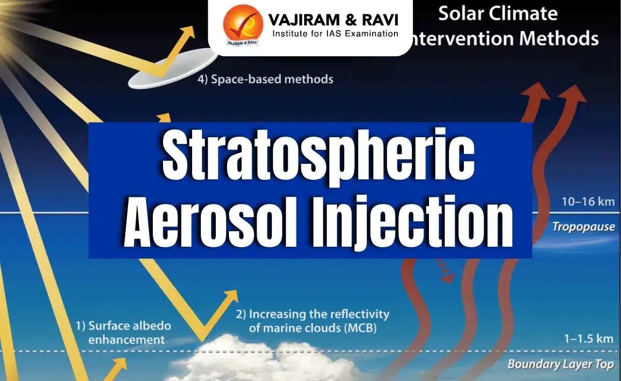
About Stratospheric Aerosol Injection

  • It is a method of cooling the planet and reducing the impacts of climate change by adding a layer of tiny reflective particles to the high atmosphere.
  • The method was inspired by volcanic eruptions, which have been known to have a cooling effect on the planet by spewing aerosols into the air.
  • It aims to mimic the cooling effects of volcanic eruptions by injecting sulfur dioxide (SO2) directly into the stratosphere, where it forms sunlight-reflecting sulfate aerosols. 

Key Facts about Aerosols

  • They are tiny solid or liquid particles suspended in air or a gas.
  • Aerosols can be natural, such as fog or gas from volcanic eruptions, or artificial, such as smoke from burning fossil fuels.
  • Aerosol particles are either emitted directly into the atmosphere (primary aerosols) or produced in the atmosphere from precursor gases (secondary aerosols).
  • Aerosol particles are tiny, but numerous, and often comprise a number of inorganic and organic substances.
  • True aerosol particles range in diameter from a few milli micrometres to about 1 micrometre (equal to 10-4 cm). 
  • Particles with a diameter of less than 0.1 micrometre are sometimes referred to as Aitken nuclei.
  • Visible forms of atmospheric aerosol plumes include smoke, smog, haze, and dust.

Stratospheric Aerosol Injection FAQs

Q1: What is the Stratosphere?

Ans: It is the layer of Earth’s atmosphere lying between the troposphere and the mesosphere. The stratosphere extends from the tropopause at about 10 to 17 km (about 6 to 11 miles) altitude to its upper boundary (the stratopause) at about 50 km (30 miles).

Q2: What is smog?

Ans: Smog is a specific type of air pollution. It is a combination of harmful pollutants (often appearing relatively low to the ground as a yellow-brown haze) that are introduced into the atmosphere by both natural and human induced processes.

Source: TH

Arsia Mons

Default Image

Arsia Mons Latest News

NASA’s 2001 Mars Odyssey orbiter recently delivered a stunning new picture from Mars, capturing the colossal Arsia Mons volcano piercing through a dense layer of early morning clouds.

About Arsia Mons

  • Arsia Mons is a massive shield volcano located in the Tharsis region of Mars.
  • It is one of the largest volcanoes in the solar system, with a height of over 18 kilometers (11 miles) and a base diameter of more than 300 kilometers (190 miles), dwarfing Earth's tallest volcano, Mauna Loa, which rises 6 miles (9 kilometers) above the seafloor.
  • Arsia Mons is part of the Tharsis Montes, a group of three large shield volcanoes on Mars.
  • It is the southernmost of the three Tharsis Montes volcanoes.
  • The volcano has a caldera (summit crater) that is approximately 110 kilometers (68 miles) wide.
  • Arsia Mons is believed to have been volcanically active for billions of years, with the most recent eruptions occurring within the past 2 million years.
  • The flanks of Arsia Mons are covered in lava flows, channels, and other volcanic features, indicating a long and complex eruptive history.
  • Arsia Mons is thought to have formed through the gradual accumulation of fluid basaltic lava flows, characteristic of shield volcano formation.

Arsia Mons FAQs

Q1. Where is Arsia Mons located?

Ans. Tharsis region of Mars

Q2. What type of volcano is Arsia Mons?

Ans. Shield volcano

Q3. How tall is Arsia Mons?

Ans. Over 18 km

Source: NDTV

Himalayan Long-Tailed Myotis

Himalayan Long-Tailed Myotis

Himalayan Long-Tailed Myotis Latest News

Recently, researchers have discovered a new species of bat named Himalayan long-tailed Myotis (Myotis himalaicus).

About Himalayan Long-Tailed Myotis

  • It is a new species of bat found in the Western Himalayan region.
  • It belongs to a group of morphologically similar species called the Myotis frater complex, which has a wide distribution from eastern China, Taiwan, central and southeastern Siberia, Korea, Japan, Tajikistan, and Uzbekistan.
  • Habitat: The Himalayan long-tailed Myotis, which inhabits Deodar, Pine, and Cedar forests, appears to be a rare species native to the southern slopes of the Himalayas.
  • Distribution: These bats have been found in Uttarakhand, India, and Khyber Pakhtunkhwa, Pakistan.

Features Of Himalayan Long-Tailed Myotis

  • It is considered “medium-sized,” reaching about 3.5 inches in length and weighing less than an ounce
  • They have “delicate” feet and “relatively long” thumbs ending in “a strong but short claw.” Their heads have “short” ears and “rather delicate” teeth.

Ecological Significance of Bats

  • Bats contribute to overall biodiversity and the health of ecosystems.
  • Insect Predators: Throughout the night, bats devour insects in farms, fields, forests, grasslands and around our homes, including agricultural pests and disease-causing mosquitoes.
  • Bat droppings (guano) mined from caves are widely used as a fertilizer for agricultural crops as they have high concentrations of nitrogen and phosphorous.
  • Pollinators: Some bats sip nectar, pollinate flowers, eat fruits, and spread the seeds of many important tree species.

Himalayan Long-Tailed Myotis FAQs

Q1: What do long-tailed bats eat?

Ans: An aerial insectivore, they feed on small moths, midges, mosquitoes and beetles.

Q2: What is the biggest bat?

Ans: The giant golden-crowned flying fox

Source: TH

Dugesia Punensis

Dugesia Punensis

Dugesia Punensis Latest News

A new species of planarian worm that regenerates, named Dugesia Punensis, has been found in the Pashan Lake in the city of Pune recently. 

About Dugesia Punensis

  • It is a new species of planarian worm.
  • Planarians are aquatic flatworms, renowned for their extraordinary regenerative capabilities.
  • It was discovered in Pashan LakePune district, Maharashtra, a wetland within the Western Ghats biodiversity hotspot.
  • It is the first time since 1983 that a new planarian species has been recorded in India.

Dugesia Punensis Features

  • The new species is characterised by its spotted appearance, slightly reduced auricles, and elongated pharynx and gonopore. 
  • The body size ranges between 8mm-12mm in length.
  • The dorsal side is spotted dark brown in appearance, with a light brown back. 
  • The ventral side looks pale. 
  • Eggs are circular and have a reddish appearance. 
  • Auricular grooves enclose two bright black eyes
  • It can completely regenerate in 10-13 days.

Dugesia Punensis FAQs

Q1. Dugesia punensis belongs to which group of animals?

Ans. Flatworms

Q2. How long does it take for Dugesia punensis to completely regenerate?

Ans. 10–13 days

Q3. In which Indian biodiversity hotspot was Dugesia punensis discovered?

Ans. Western Ghats

SourceNDTV

National Automated Fingerprint Identification System

National Automated Fingerprint Identification System

National Automated Fingerprint Identification System Latest News

Recently, the Centre has revised the procedure for the Foreigners Identification Portal (FIP) of the National Automated Fingerprint Identification System (NAFIS) and asked states/UTs to use fingerprint scanners available in districts under districts police module (DPM) of Immigration Visa Foreigner Registration Tracking system (IVFRT).

About National Automated Fingerprint Identification System

  • It is a pan-India searchable database of crime and criminal-related fingerprints. 
  • Objective: To collect fingerprint data of all the criminals from all the states and the Union Territories.
  • It will enable law enforcement agencies to upload, trace and retrieve information from the database 24x7 in real-time.
  • It is managed by the National Crime Records Bureau (NCRB) at the Central fingerprint bureau, based in New Delhi.
  • With NAFIS, it is possible to locate a person of interest in a matter of minutes and connect that individual’s name to any active warrants, warnings, or information about related criminal conduct stored in other police information reference systems.

Working of NAFIS

  • It assigns a unique 10-digit National Fingerprint Number for each criminal, based on biometrics.
  • The unique ID will be used for a lifetime of an offender. Different crimes registered under different FIRs will be logged as incidents belonging to the same National Fingerprint Number.
  • The first two digits of the ID will be the state code of the state where the criminal is registered, followed by a sequence number.
  • The state partition will have IDs belonging to a state. 
  • Apart from this, a digital record will be added as storage to match the fingerprints in the future.

National Automated Fingerprint Identification System FAQs

Q1: Which ministry is NAFIS under?

Ans: Ministry of Home Affairs

Q2: What is the full form of NCRB?

Ans: NATIONAL CRIME RECORDS BUREAU

Source: IE

Ejiao

Ejiao

Ejiao Latest News

Recently, there has been a sudden surge in donkey prices in Pakistan due to China’s demand for ejiao.

About Ejiao

  • It is a gelatin used in traditional Chinese medicine, made by stewing and concentrating donkey skin.
  • It is widely used in clinics for its biological advantages of being anti-fatigue, immunity-improving properties, for tumour suppression, and for its anti-anaemia effect.
  • It is produced from the collagen extracted from donkey skin.
  • The collagen is mixed with herbs and other ingredients to create bars, pills or liquids for consumable goods or beauty products.
  • Between 2013 and 2016, the annual production of ejiao increased from 3,200 to 5,600 tonnes, a yearly growth of over 20%.
  • China’s ejiao industry has witnessed a 160 per cent growth in the past five years, fuelling more demand for millions of donkey hides annually. 
  • Pakistan is only behind Ethiopia and Sudan in being home to the largest number of donkeys.

Ejiao FAQs

Q1: What is Ejiao in English?

Ans: Ejiao is also known as 'colla corii asini' or 'donkey-hide glue.

Q2: How is donkey gelatin made?

Ans: It is gelatin obtained from the skin of the donkey by soaking and stewing.

Source: TH

Tamhini Wildlife Sanctuary

Tamhini Wildlife Sanctuary

Tamhini Wildlife Sanctuary Latest News

Maharashtra forest department recently partnered with Microsoft and the Centre for Youth Development and Activities (CYDA), Pune, to address socio-ecological challenges in the Tamhini Wildlife Sanctuary.

About Tamhini Wildlife Sanctuary

  • It is a protected forest area located in the Western Ghats near Pune, Maharashtra.
  • It covers an area of 49.62 sq.km.
  • It has been carved out by taking 12 compartments of reserved forest from the Paund and Sinhgad ranges in the Pune forest division, while 8 compartments belong to Mangaon range in the Roha division in Thane.
  • Vegetation: It is made up of evergreen forests, semi-evergreen forests, and most deciduous forests.
  • Flora: Species like teak, bamboo, Ain, Shisham, mango, and Jamun are found in this area.
  • Fauna
  • Indian giant squirrels, barking deer, Indian pangolins, Indian civets, and wild boars are some of the many species found in this region.
  • In terms of avifauna population, species like the Malabar whistling thrush, crested serpent eagle, grey junglefowl, golden oriole, and Indian pitta are some of the residents.

Tamhini Wildlife Sanctuary FAQs

Q1: Where is the Tamhini Wildlife Sanctuary located?

Ans: Western Ghats, Maharashtra

Q2: What is the approximate area covered by Tamhini Wildlife Sanctuary?

Ans: 49.62 sq.km

Q3: Tamhini Wildlife Sanctuary lies near which major city?

Ans: Pune

Source: IE

Thitu Island

Thitu Island

Thitu Island Latest News

A Chinese ship was recently struck aground in severe weather in shallow seas off Philippine-occupied Thitu island in the disputed South China Sea, causing Filipino soldiers to be on high alert.

About Thitu Island

  • Thitu Island (also known as Pag-asa Island in the Philippines) is located in the South China Sea, specifically within the Spratly Islands archipelago.
  • The Spratly Islands consist of more than 100 small islands or reefs in the South China Sea.
  • They are claimed in their entirety by China, Taiwan, and Vietnam, while portions are claimed by Malaysia and the Philippines.
  • Thitu Island is the second largest of the naturally occurring Spratly Islands and the largest of nine islands occupied by the Philippines.
  • Thitu Island is home to a Philippine fishing village and Filipino forces.
  • It has been administered by the Philippines since 1971, with civilian settlement initiated in the mid‑1990s.
  • It has a permanent civilian population, including a school and airport (Rancudo Airfield), a large harbor, and a lighthouse for navigation. 
  • It is only about 24–27 km from China’s Subi Reef, which hosts a large military base.

Thitu Island FAQs

Q1: Thitu Island is located in which group of islands?

Ans: Spratly Islands

Q2: What is the name of the airfield located on Thitu Island?

Ans: Rancudo Airfield

Q3: What is the significance of Thitu Island for the Philippines?

Ans: It provides strategic and civilian presence in the South China Sea.

SourceFP

Neglected Tropical Diseases (NTDs)

Neglected Tropical Diseases (NTDs)

Neglected Tropical Diseases Latest News

As of May 2025, 56 countries have successfully eliminated at least one NTD – demonstrating significant progress towards WHO’s global target of 100 countries reaching elimination by 2030.

About Neglected Tropical Diseases

  • NTDs are a diverse group of conditions caused by a variety of pathogens (including viruses, bacteria, parasites, fungi, and toxins) and associated with devastating health, social, and economic consequences.
  • NTDs are mainly prevalent among impoverished communities in tropical areas, although some have a much larger geographical distribution.
  • They are widespread where people in vulnerable situations live, where water safety, sanitation, and access to health care are inadequate or suboptimal. 
  • These diseases are called “neglected” because they have historically ranked very low on the global health agenda, when they have appeared at all, receiving little attention and funding.
  • NTDs include Guinea worm, Chikungunya, Dengue, Kala Azar (Visceral Leishmaniasis), and Elephantiasis (Lymphatic Filariasis), among others. India is home to about 12 NTDs.
  • The epidemiology of NTDs is complex; some have animal and/or human reservoirs, many are vector-borne, and most are associated with intricate life cycles. Preventing or eliminating NTDs is therefore challenging.
  • It is estimated that NTDs affect more than 1 billion people, while the number of people requiring NTD interventions (both preventive and curative) is 1.5 billion.
  • Every year on 30th January, the global community comes together to mark World NTDs Day and renew its commitment to eliminating its burden worldwide.

Neglected Tropical Diseases FAQs

Q1: Why are Neglected Tropical Diseases referred to as “neglected”?

Ans: Because they have historically received little global attention and funding.

Q2: What is the primary reason NTDs are difficult to eliminate?

Ans: They often have complex life cycles, vectors, and reservoirs.

Q3: When is World Neglected Tropical Diseases Day observed globally?

Ans: 30th January

SourceWHO

Enquire Now