Yuan Wang 5

Yuan Wang 5

Yuan Wang 5 Latest News

China’s spy ship Yuan Wang 5 has returned to the maritime neighbourhood of India, three years after it had docked at Hambantota Port of Sri Lanka.
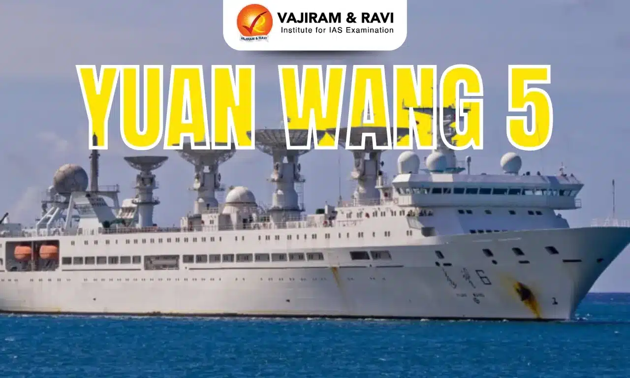
About Yuan Wang 5

  • Launched in 2007, Yuan Wang 5 is part of a series of specialized tracking ships built by China for strategic space and missile monitoring. 
  • It is operated by China’s People’s Liberation Army Strategic Support Force.
  • It can provide near-real-time situational awareness to the PLA Rocket Force and Navy.
  • It also plays a role in validating the performance of China’s new generation of intercontinental ballistic missiles and hypersonic weapons, providing telemetry data critical for weapons development and operational readiness.

Yuan Wang 5 Features

  • It displaces about 25,000 tons, has a length of over 222 metres, a beam of over 25 metres, and can accommodate 400 people.
  • The ship is driven by diesel engines and can generate sufficient electricity to light up a small town of over 300,000 inhabitants. 
  • With endurance measured in weeks, the ship can remain on station during key test windows or naval exercises.
  • Its suite of high-power phased-array radar systems is capable of detecting ballistic missile launches at distances exceeding 3,000 kilometers.
  • These radars track the trajectory of missiles through various flight stages, from boost to reentry, while simultaneously collecting telemetry signals that reveal propulsion performance, warhead separation, and guidance accuracy.
  • In addition to ballistic missile monitoring, Yuan Wang 5 is equipped with satellite-tracking antennas that can lock onto spacecraft in low-earth orbit, geostationary orbit, and deep-space trajectories.
  • These antennas are estimated to operate in multiple frequency bands, giving the ship flexibility to track both civilian and military launches. 
  • The vessel’s electronic support measures (ESM) suite further enables it to intercept radar emissions and communications from foreign warships and aircraft operating in the vicinity.

Source: DH

Yuan Wang 5 FAQs

Q1: What is Yuan Wang 5?

Ans: A missile-tracking and satellite-tracking ship.

Q2: Which country developed Yuan Wang 5?

Ans: China

Q3: Yuan Wang 5’s radar can detect missile launches at what approximate maximum distance?

Ans: It is capable of detecting ballistic missile launches at distances exceeding 3,000 kilometers.

Lactifluus khasianus

Lactifluus khasianus

Lactifluus khasianus Latest News

Researchers recently discovered a new species of edible mushroom, now formally named Lactifluus khasianus—but long known to Khasi tribal communities as “Tit iongnah.”

About Lactifluus khasianus

  • It is a new species of edible mushroom.
  • It was discovered in Meghalaya’s East Khasi Hills.
  • It is long known to Khasi tribal communities as “Tit iongnah.”
  • Belonging to the Lactifluus sect. Gerardii, the new species, stands out for its chocolate-brown cap, distinctive microscopic features, and genetic markers. 
  • It grows in association with Khasi pine (Pinus kesiya) at altitudes of around 1,600 metres.
  • Though it resembles the widespread Lactifluus gerardii found in North America and Asia, L. khasianus differs in its larger cystidia (specialised fungal cells) and DNA signatures. 
  • It is now the fifth confirmed species of this section in India—and notably, the first to be reported as edible.
  • For Khasi villagers, however, the mushroom has never been a stranger.
    • “Tit iongnah” has long been gathered from the forest floor, sold in local markets during the monsoon, and savoured as a seasonal delicacy.

Source: HUB

Lactifluus khasianus FAQs

Q1: What type of organism is Lactifluus khasianus?

Ans: It is a new species of edible mushroom.

Q2: In which district of Meghalaya was Lactifluus khasianus found?

Ans: East Khasi Hills

Q3: What is the Khasi tribal name for Lactifluus khasianus?

Ans: Tit iongnah

Project Vijayak

Project Vijayak

Project Vijayak Latest News

Recently, the Project Vijayak of the Border Roads Organisation (BRO) celebrated its 15th Raising Day at Kargil, Ladakh. 

About Project Vijayak

  • It was launched by the Border Roads Organisation in 2010.
  • It drew its name from Operation Vijay, signifying the congruence between the Theatre of Battle and the Project Area of Responsibility.
  • Objective: It was entrusted with the responsibility of providing road connectivity in the areas of Kargil and Zanskar, which previously were under Project Himank.
  • The project was entrusted with two strategically important lines of communication in the Western Indus Corridor, namely, the Zojila - Kargil - Leh axis and Nimmu - Padam - Darcha axis.
  • This project has played a significant role in strengthening the security infrastructure along the LC and has also contributed positively in shaping the socio-economic landscape of the region.
  • Other Initiatives under Project
    • It has also placed strong focus on welfare of its Casual Paid Labourers.
    • Welfare initiatives such as insulated shelters, improved sanitation, enhanced protective gear, winter clothing, and regular health camps have been introduced to ensure safety and well-being.

Source: PIB

Project Vijayak FAQs

Q1: Where is the headquarters of BRO located?

Ans: New Delhi

Q2: What is the role of Border Roads Organisation?

Ans: It develops and maintains road networks in India’s border areas and friendly neighboring countries.

Bagram Air Base

Bagram Air Base

Bagram Air Base Latest News

The Taliban government recently rejected U.S. President Donald Trump’s bid to retake Bagram Air Base, four years after America’s chaotic withdrawal from Afghanistan left the sprawling military facility in the Taliban hands.

About Bagram Air Base

  • It is the largest air base in Afghanistan, located north of the capital, Kabul.
  • It has a strategic position at the crossroads of Iran, Pakistan, China's Xinjiang province, and Central Asia.
  • It was built during the Cold War by the Soviet Union. 
  • The airbase served Soviet operations in the country for decades until they withdrew in the late 1980s.
  • The US revamped the facility following its own occupation of Afghanistan decades later.
  • It had served as a crucial hub in the US war against the Taliban and Al Qaeda since 2001. 
    • It was the largest American military installation in Afghanistan.
    • It served as a hub for air operations, intelligence, and logistics throughout the war.
    • The air base had, at its peak in 2012, more than 100,000 US troops passing through its compound.
  • Features:
    • It has runways longer than many international airports, and hardened shelters, hospitals, and fuel depots.
    • The base also housed fast-food restaurants to cater to the US troops, along with shops selling everything from electronics to Afghan rugs. 
    • Bagram also had a massive prison complex.
  • The base fell under the control of the Taliban after they swept to power in the country in 2021, with the US troops having withdrawn from the country.
  • US forces officially vacating Bagram Air Base in July 2021 was seen as a symbolic end to America's 20-year military presence in Afghanistan.

Source: TH

Bagram Air Base FAQs

Q1: What is the largest military base in Afghanistan?

Ans: Bagram Air Base

Q2: Which country originally built Bagram Air Base?

Ans: It was built during the Cold War by the Soviet Union.

Q3: When did the Taliban take control of Bagram Air Base?

Ans: The base fell under the control of the Taliban after they swept to power in the country in 2021, with the US troops having withdrawn from the country.

Q4: What feature made Bagram Air Base suitable for US military operations?

Ans: Long runways, hardened shelters, and large compound for logistics.

Key Facts about Mozambique

Mozambique

Mozambique Latest News

Recently, the Indian Navy’s First Training Squadron comprising INS Tir, INS Shardul, INS Sujata, and ICGS Sarathi concluded its four-day port visit to Maputo, Mozambique.

About Mozambique

  • Location: It is a country in Southern Africa and is located in the Southern and Eastern Hemispheres of the Earth.
  • The country also has a coastline on the Indian Ocean to the east.
  • The island countries and territories of Madagascar, Comoros, and Mayotte are separated from Mozambique by the Mozambique Channel.
  • Bordering countries: Zimbabwe (west), Eswatini and South Africa (south and southwest), Zambia, Malawi (north west), and Tanzania (North). 
  • Rivers: The River Zambezi being the largest and other rivers are Limpopo, Licungo, Lurio, Rovuma etc.
  • Major Lakes: Lake Malawi (Nyasa) is the country’s major lake. 
  • Highest Peak: Mount Binga
  • Capital: Maputo is the country’s capital while the largest city is Matola.
  • Natural Resources: The country’s principal natural resources are natural gas, coal, mineral, sand, hydropower, and most likely oil.

Source: PIB

Mozambique FAQs

Q1: Which ocean borders Mozambique to the east?

Ans: Indian Ocean

Q2: What is the official language of Mozambique?

Ans: Portuguese

National Archives of India

National Archives of India

National Archives of India Latest News

Recently, the 50th Golden Jubilee Meeting of the National Committee of Archivists (NCA), organized by the National Archives of India (NAI).

About National Archives of India

  • It is the custodian of the records of enduring value of the Government of India. 
  • History of National Archives of India
    • It was originally established as the Imperial Record Department on 11 March 1891 in Kolkata (Calcutta). 
    • It was transferred to New Delhi in 1911.
  • The NAI also serves as the nodal agency for implementing the Public Records Act, 1993, and the Public Record Rules, 1997.
  • A significant portion of its oriental records is in Sanskrit, Persian, Odia, and other languages.
  • Access to the records in the NAI is governed by the provisions of the Public Records Rules, 1997.
  • The NAI keeps and conserves records of the government of India and its organisations. It does not receive classified documents.
  • Headed by: Director General of Archives
  • Nodal Ministry: Ministry of Culture.
  • Location: New Delhi and has one regional office at Bhopal and three Records Centers at Bhubaneswar, Jaipur, and Puducherry.

Source: PIB

National Archives of India FAQs

Q1: Under which ministry does the National Archives of India function?

Ans: Ministry of Culture

Q2: Where is the National Archives of India located?

Ans: New Delhi

Q3: What type of records does the National Archives of India hold?

Ans: A vast corpus of records including public records, private papers, oriental records, cartographic records, and microfilms

Chenab River

Chenab River

Chenab River Latest News

Recently, the stalled Sawalkote dam on the Chenab river is back at the centre of India’s strategy to tap the river’s hydropower potential.

About Chenab River

  • It is a tributary of the Indus River.
  • Origin: It is formed by the confluence of two streams, Chandra and Bhaga, in the Lahaul and Spiti Districts of Himachal Pradesh.
  • In its upper reaches, it is also known as the Chandrabhaga.
  • It flows through Jammu and Kashmir union territory, Himachal Pradesh and after receiving the Jhelum River near Trimmu, the Chenab empties into the Sutlej River.
  • Major Tributaries:
    • Left Bank:  Niru, Tawi, Neeru, and Liddrari
    • Right Bank: Ans, Bhut Nalla, Bichleri, Kalnai Marusudar and Miyar Nalla.
  • Major Dams on Chenab River: Salal (rockfill dam), Aalal (concrete dam), Baglihar, and Dul. 
  • The waters of the Chenab are shared by India and Pakistan as per the terms of the Indus Water Treaty.

What is the Indus Waters Treaty (IWT)?

  • It was signed in 1960 between India and Pakistan, with the World Bank acting as a mediator. 
  • The treaty outlines water usage rights over six rivers of the Indus River System, categorizing them into Eastern and Western rivers. 
  • The Eastern rivers—Ravi, Beas, and Sutlej—are allocated for India’s exclusive and unrestricted use. 
  • The Western rivers—Indus, Jhelum, and Chenab—are allocated primarily to Pakistan.

Source: IE

Chenab River FAQs

Q1: What is the largest tributary of Chenab River?

Ans: Marusudar

Q2: Chenab River is a tributary of which major river?

Ans: Indus River

Baltic Sea

Baltic Sea

Baltic Sea Latest News

Germany's air force recently sent two Eurofighters to track a Russian IL-20M military aircraft that had entered neutral airspace over the Baltic Sea before handing the escort over to NATO partners in Sweden.

About Baltic Sea

  • It is a semi-enclosed inland sea of the Atlantic Ocean, situated in Northern Europe.
  • It extends northward from southern Denmark to within a few degrees latitude of the Arctic Circle, separating the Scandinavian Peninsula from continental Europe.
  • It comprises several branches and basins, which include, from northeast to southwest, the Gulf of Bothnia, the Gulf of Finland, and the Gulf of Riga; the central-southern area known as the Baltic Proper; and the Danish straits of Kattegat and Skagerrak, which connect to the North Sea, an arm of the Atlantic Ocean. 
  • To the east, the White Sea-Baltic Canal, opened by Russia in 1993, allows traffic from the Baltic—via the Gulf of Finland and a chain of rivers and major lakes—to the White Sea, itself an arm of the Arctic Ocean.
  • To the southwest, the Kiel Canal, opened in 1895, cuts through the Jutland peninsula to connect the Baltic with the North Sea.
  • It is the youngest sea on our planet, emerging some 10,000-15,000 years ago as the glaciers retreated at the end of the last Ice Age.
  • It is approximately 1,600 km long and 193 km wide, covering an area of approximately 377,000 sq.km.
  • Surrounding Countries: It has a coastline of approximately 8,000 km, shared by several countries, including Sweden, Poland, Lithuania, Latvia, Finland, Estonia, Germany, Denmark, and Russia. 
  • It is often cited as the world’s largest brackish inland water body. 
  • Its water salinity levels are lower than that of the world oceans due to the inflow of fresh water from the surrounding land and the sea’s shallowness. 
  • There are about sixty rivers draining into the Baltic Sea. Neva is the largest river that drains into the Baltic Sea.
  • Islands: It is home to over 20 islands and archipelagos. Gotland, located off the coast of Sweden, is the largest island in the Baltic Sea.
  • Algal Harmful Blooms are also one of the issues that affect the Baltic Sea.

Source: TH

Baltic Sea FAQs

Q1: The Baltic Sea is a semi-enclosed inland sea of which ocean?

Ans: Atlantic Ocean

Q2: The Baltic Sea is connected to the North Sea through which straits?

Ans: Kattegat and Skagerrak

Q3: Which is the largest river draining into the Baltic Sea?

Ans: Neva

Q4: Gotland, the largest island in the Baltic Sea, belongs to which country?

Ans: Sweden

Q5: Which canal connects the Baltic Sea with the North Sea through the Jutland Peninsula?

Ans: Kiel Canal

Indrayani River

Indrayani River

Indrayani River Latest News

State level technical committee (SLTC) recently approved two sewage treatment plant (STP) projects along the Indrayani River in Pimpri Chinchwad to curb water pollution.

About Indrayani River

  • It is a river located in the state of Maharashtra.
  • It is a tributary of the Bhima River (a tributary of the Krishna River).
  • Course
    • It is a rain-fed river that originates from the Western Ghats, near the hill station of Lonavala, located along the Mumbai-Pune Highway. 
    • It flows through the Pune district before merging into the Bhima River at Tulapur.
    • It travels a total length of 105.3 km.
  • The river has great religious importance, and the two sacred towns, Alandi and Dehu, are situated on its banks.
    • Dehu is known to be a sacred place for being the hometown of the poet Saint Tukaram, who was a popular saint of Maharashtra, and Alandi holds the samadhi of the poet Dnyaneshwar.
  • The Indrayani also passes through the industrial town of Pimpri-Chinchwad and plays a role in irrigation and local agriculture.
  • Valvan Dam at Kamshet, situated on the Indrayani River, is a hydroelectric generating station.

Source: TOI

Indrayani River FAQs

Q1: The Indrayani River is a tributary of which river?

Ans: Bhima

Q2: Where does the Indrayani River originate?

Ans: It originates from the Western Ghats, near the hill station of Lonavala.

Q3: The Indrayani River flows through which Indian state?

Ans: Maharashtra

Q4: What is the approximate length of the Indrayani River?

Ans: 105.3 km

Q5: Which industrial town does the Indrayani River pass through?

Ans: Pimpri-Chinchwad

Clean Plant Programme

Clean Plant Programme

Clean Plant Programme Latest News

The Clean Plant Programme (CPP) which was approved by the Union Cabinet is gaining momentum in its implementation.

About Clean Plant Programme

  • It was conceptualized by the Ministry of Agriculture & Farmers Welfare in collaboration with the Asian Development Bank.
  • It was launched as a major initiative to provide farmers with access to high-quality, virus-free planting material of key fruit crops.
  • Implemented by: It is implemented by the National Horticulture Board (NHB) in association with Indian Council of Agricultural Research (ICAR)
  • Components of Clean Plant Programme
    • Establishment of Nine Clean Plant Centers (CPCs): These centres will offer disease diagnostics and treatments, develop mother plants for nurseries, and quarantine all domestic and imported planting materials intended for commercial propagation and distribution.
    • Infrastructure Development: This includes setting up large-scale nurseries to efficiently multiply clean planting material. The mother plants produced by the CPCs will be propagated in these nurseries and then distributed to farmers.
    • Regulatory and Certification Framework: A regulatory and certification process will be created to ensure complete accountability and traceability in the production and distribution of planting material.

Source: PIB

Clean Plant Programme FAQs

Q1: What are the objectives of the clean plant program?

Ans: It is designed to address critical issues in horticulture by providing access to high-quality, virus-free planting material.

Q2: Who launched the Clean Plant program?

Ans: The Union government of India

Enquire Now