Dornier 228 Aircraft

Dornier 228 Aircraft

Dornier 228 Aircraft Latest News

Recently, the Defence Ministry has signed a contract with Hindustan Aeronautics Limited (HAL), Transport Aircraft Division, Kanpur, for the acquisition of eight Dornier 228 Aircraft.

About Dornier 228 Aircraft

  • It is a highly versatile multi-purpose light transport aircraft.
  • It has been developed specifically to meet the manifold requirements of utility and commuter transport, third level services and air-taxi operations, coast guard duties and maritime surveillance.
  • Manufacturing: In 1983, Hindustan Aeronautics (HAL) bought a production licence and two years later commenced aircraft manufacture in India.

Features of Dornier 228 Aircraft

  • It is powered by a pair of Garrett TPE331 turboprop engines and has a supercritical wing that generates large amounts of lift at slow speeds.
  • It is a twin-turboprop aircraft known for its reliable performance and short takeoff and landing (STOL) capabilities. 
  • The STOL capabilities allows it to operate from unprepared, unpaved, and grass surfaces and specialize in hot and high environments.
  • It has the unique design of the TNT wing, capable of generating large amounts of lift at slow speeds.
  • The Dornier 228 is typically promoted for its versatility, low operational costs, and high levels of dispatch reliability.

Source: ET

Dornier 228 Aircraft FAQs

Q1: What type of aircraft is the Dornier 228?

Ans: Multi-purpose light transport aircraft

Q2: Who manufactures the Dornier 228 in India?

Ans: Hindustan Aeronautics Limited

Phoenicia

Phoenicia

Phoenicia Latest News

Archaeologists excavating near ruins on the island of Sardinia discovered an Iron Age scarab amulet that originated from ancient Phoenicia.

About Phoenicia

  • Phoenicia was an ancient region at the eastern end of the Mediterranean Sea. 
  • It covered the land where the country of Lebanon is today. 
  • The people who lived there were called Phoenicians. They traded with many other peoples and set up many colonies.
  • The Phoenicians lived on the seacoast and made their living from the sea. They were skilled shipbuilders and navigators. 
  • Their trade routes reached as far as Spain and the British Isles. 
  • The Phoenicians traded wood, linen, dyes, and wine
  • They also carved wood and ivory and worked with metals and glass
  • The art of glassblowing was probably invented in Phoenicia.
  • The Phoenicians spoke a language that was similar to Hebrew. They had their own form of writing and an alphabet of 22 letters. 
  • The Phoenician alphabet was the source of the Greek alphabet and of the Latin alphabet, which most people use today.
  • Historians think that the Phoenicians arrived in Phoenicia in about 3000 BCE. They probably came from the region of the Persian Gulf, to the southeast. 
  • They built the cities of Sidon, Tyre, and Berot (modern Beirut). 
  • The Phoenicians set up colonies all around the Mediterranean. Carthage, in North Africa, was a very successful colony. Eventually Carthage became a power in its own right.
  • Decline:
    • Over the centuries a number of foreign powers controlled all or parts of Phoenicia. They included Egypt, Assyria, Babylonia, and Persia. 
    • The Macedonians, led by Alexander the Great, conquered Phoenicia in 332 BCE. 
    • In 64 BCE Phoenicia became a part of the Roman Empire.

Source: PM

Phoenicia FAQs

Q1: What was Phoenicia?

Ans: Phoenicia was an ancient region at the eastern end of the Mediterranean Sea.

Q2: In which crafts were the Phoenicians skilled?

Ans: They carved wood and ivory and worked with metals and glass.

Q3: What important invention is believed to have originated in Phoenicia?

Ans: The art of glassblowing was probably invented in Phoenicia.

Q4: What was the Phoenician language similar to?

Ans: It was similar to Hebrew.

Q5: Which major cities were built by the Phoenicians?

Ans: They built the cities of Sidon, Tyre, and Beirut (ancient Berot).

Chunar Fort, Location, Architecture, History, Recent Development

Chunar Fort

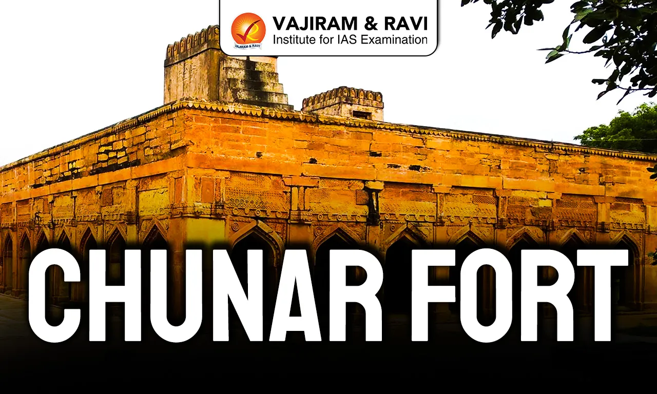
Chunar Fort is also known as Chandrakanta Chunargarh and Charanadri. It stands in Mirzapur district of Uttar Pradesh. It is built on an isolated spur of the Vindhya Range 85 meters above sea level and overlooks a strategic bend of the Ganges near the Kaimur Hills. It is traditionally believed to be established by Maharaja Vikramaditya of Ujjain in the 11th century. Its occupation is traced back to 56 BC. Over centuries, it passed through the hands of Sher Shah Suri, the Mughals, the Nawabs of Awadh, Kashi rulers and finally the British until 1947.

Chunar Fort Features

The major highlighting features of the Chunar Fort has been listed below:

  • Strategic Location: Built on a steep rocky bluff projecting into the Ganges, the fort commands river navigation for 50 to 60 ton boats. The hill rises sharply 32 meters from the river and further to 85 meters, making direct assault difficult and allowing artillery batteries to dominate the river channel.
  • Political Control Struggles: Sher Shah Suri secured it in 1532 through strategic alliances. Humayun besieged it for four months. Akbar captured it in 1575 and built the west gate in 1586. It later shifted between Nawab of Awadh, Kashi Naresh and British control until Independence in 1947.
  • Architecture: Spread roughly 690 meters north to south with ramparts extending 1,690 meters, the fort used local sandstone from Mauryan era quarries. It contains a citadel with cannon placements, a 15 foot diameter deep well, underground dungeons and tiered defensive walls with 10 to 20 foot high towers.
  • Religious Associations: Linked to King Bali and the name Charanadri, it is associated with Vikramaditya and Bharthari. Sonwa Mandap, built in 1538 with 28 pillars, includes a deep 61 meter well connected to the Ganges, reinforcing its sacred and cultural dimension.
  • Colonial Background: It functioned as an artillery depot, prison and refuge during 1857. Rani Jind Kaur was imprisoned here in 1849 before escaping to Kathmandu. 
  • Recent Development: Today, it is being developed as a ₹150 crore PPP based 100 room heritage hotel to boost river tourism and regional economy.

Also Read: Amagarh Fort

Chunar Fort FAQs

Q1: Where is Chunar Fort located?

Ans: Chunar Fort is located in Mirzapur district of Uttar Pradesh, about 34 km from Mirzapur and 23 km southwest of Varanasi, on the bank of the Ganges River.

Q2: Who captured Chunar Fort in 1532?

Ans: Sher Shah Suri took control of Chunar Fort in 1532 and strengthened his political position in North India from this strategic base.

Q3: Why was Chunar Fort strategically important?

Ans: The fort overlooks a key bend of the Ganges River and controlled river navigation and major land routes toward eastern India.

Q4: Which Mughal emperor built the west gate of the fort?

Ans: Emperor Akbar captured the fort in 1575 and constructed the west gate in 1586, as marked by an inscription.

Q5: What is the present development plan for Chunar Fort?

Ans: The Uttar Pradesh government plans to convert it into a ₹150 crore heritage hotel under a Public Private Partnership model to promote tourism.

Wheat

Wheat

Wheat Latest News

Recently, the government allowed export of 25 lakh tonnes of wheat, along with an additional 5 lakh tonnes of wheat products after 4 years.

About Wheat

  • Wheat is the second most important staple food crop in India after rice.
  • It is a temperate crop that thrives in cool and dry climates.
  • It is primarily grown as a Rabi crop, meaning it is sown in the winter season and harvested in spring.
  • Required climatic conditions for wheat cultivation
    • Temperature: A cool temperature (10°C to 15°C) during sowing and 21°C to 26°C during ripening ensures optimum growth and grain quality.
    • Rainfall: Wheat requires 50-75 cm of well-distributed rainfall.
    • Excessive rain or humidity during the ripening period can harm the crop, while drizzles brought by Western Disturbances in northwestern India during winter significantly improve yields.
    • Sunlight: Bright sunshine during ripening improves grain formation and quality.
    • Frost: Frost or hailstorms during the flowering stage can damage the crop severely.
    • Soil: It grows well in a clay loam or loam texture soil.
  • Major Wheat Producing Countries: China, India, Russia and the United States.
  • Major Wheat Producing States: Punjab, Haryana, Uttar Pradesh, and Bihar.

Source: IE

Wheat FAQs

Q1: Which season is wheat typically grown in India?

Ans: Rabi

Q2: What is the scientific name of wheat?

Ans: Triticum aestivum

Key Facts about Barbados

Key Facts about Barbados

Barbados Latest News

Recently, the Prime Minister of India congratulated Barbados Mia Amor Mottley on securing a historic third consecutive electoral victory.

About Barbados

  • Location: It is an island country located in the south eastern Caribbean region of North America.
  • It lies to the east of St. Lucia, St. Vincent and the Grenadines; to the southeast of Martinique; to the northeast of Trinidad and Tobago.
  • It is the easternmost island in the Caribbean.
  • Water Bodies: Barbados is surrounded by the Atlantic Ocean.
  • It is part of the Caribbean Community (CARICOM) which was established in 1973.
  • Capital City: Bridgetown
  • Independence: Barbados became independent on November 30, 1966.

Geographical Features of Barbados

  • Terrain: The terrain of Barbados is gentle sloping, terraced plains separated by rolling hills.
  • Climate: Its climate is classified as a tropical monsoon. It experiences both the wet and dry seasons.
  • Highest Point: The highest point on the island is Mount Hillaby which measures 340 meters above sea level.
  • Natural Resources: Barbados's chief natural resources are petroleum, fish, and natural gas. 

Source: DD News

Barbados FAQs

Q1: Where is Barbados located?

Ans: Caribbean Sea

Q2: What is the capital of Barbados?

Ans: Bridgetown

Tetrataenium Paikadae

Tetrataenium Paikadae

Tetrataenium Paikadae Latest News

A team of researchers recently discovered a new plant species named Tetrataenium paikadae in the high-altitude grasslands of Idukki district of the Western Ghats.

About Tetrataenium Paikadae

  • It is a new plant species.
  • It was discovered in the high-altitude grasslands of the Western Ghats in the Idukki district, Kerala.
  • It was identified inside Eravikulam National Park and belongs to the Apiaceae family, which includes commonly known plants such as carrot and coriander.
  • The newly discovered species thrives in moist, marshy grasslands at elevations ranging between 1,000 and 2,500 metres above sea level. 
  • The plant grows to a height of 30 to 80 centimetres, and it has densely stiff-haired stems, ovate leaves, and clusters of small white flowers.
  • It typically flowers between July and September, while fruiting occurs from October to November. 
  • Researchers distinguished Tetrataenium paikadae from closely related species based on the number and structural arrangement of oil tubes present in its fruits.

Source: ETVB

Tetrataenium Paikadae FAQs

Q1: What is Tetrataenium paikadae?

Ans: It is a newly discovered plant species.

Q2: Where was Tetrataenium paikadae discovered?

Ans: It was discovered in the high-altitude grasslands of the Western Ghats in the Idukki district of Kerala.

Q3: To which plant family does Tetrataenium paikadae belong?

Ans: It belongs to the Apiaceae family.

Q4: In what type of habitat does Tetrataenium paikadae thrive?

Ans: It thrives in moist, marshy grasslands.

Chennakeshava Temple

Chennakeshava Temple

Chennakeshava Temple Latest News

The Prime Minister’s new office complex, Seva Teerth has been built in the Indian architectural tradition inspired by the features of the 12th-century Chennakeshava Temple.

About Chennakeshava Temple

  • The Chennakeshava Temple, also referred to as the Keshava, or Vijayanarayana Temple of Belur, is a 12th-century temple in Karnataka.
  • It is a Hindu temple dedicated to Lord Vishnu. 
  • It was commissioned by King Vishnuvardhana in 1117 CE (after a major military victory in 1116 CE over the Cholas in the great battle of Talakkad), on the banks of the Yagachi River in Belur, also known as Velapura. 
  • The temple was built over three generations and took 103 years to complete.
  • The temple is listed as a UNESCO World Heritage Site.

Chennakeshava Temple Architecture

  • It is a stunning example of Hoysala architecture.
  • The Hoysalas used soft soapstone for their structures, as they were found suitable for intricate carvings. 
  • Enclosed by a Prakara with a Gopura built in the Vijayanagar style, the temple stands on a platform, or Jagati, and looks like a huge casket.
  • The outer walls of the temple are adorned with intricate carvings, which depict various gods, goddesses, and mythical creatures.
  • There are more than 80 Madanika sculptures in the temple, dancing, hunting, standing under canopies of trees, and so on. 
  • One of the unique features of the Chennakeshava Temple is the stepped well, which is located in the temple complex.

Source: TI

Chennakeshava Temple FAQs

Q1: What is the Chennakeshava Temple also known as?

Ans: It is also known as the Keshava Temple or Vijayanarayana Temple of Belur.

Q2: Where is the Chennakeshava Temple located?

Ans: It is located in Belur (also known as Velapura) in Karnataka.

Q3: In which century was the Chennakeshava Temple built?

Ans: It was built in the 12th century.

Q4: Who commissioned the Chennakeshava Temple?

Ans: It was commissioned by King Vishnuvardhana.

Q5: In which year was the temple commissioned?

Ans: It was commissioned in 1117 CE.

Combined Maritime Forces

Combined Maritime Forces

Combined Maritime Forces Latest News

Recently, the Indian Navy has assumed command of Combined Task Force (CTF) 154, a key multinational training task force under the Combined Maritime Forces (CMF).

About Combined Maritime Forces

  • It is a multinational maritime partnership that upholds the International Rules Based Order (IRBO) by countering illicit non-state actors on the high seas.
  • It promotes security, stability and prosperity across approximately 3.2 million square miles of international waters, which encompass some of the world’s most important shipping lanes.
  • Mandate: Its main focus areas are counter-narcotics, counter-smuggling, suppressing piracy, encouraging regional cooperation, and engaging with regional and other partners to strengthen relevant capabilities and improve overall security and stability, and promote a safe maritime environment free from illicit non-state actors.
  • CMF has five Combined Task Forces
    • CTF 150 (Maritime Security Operations outside the Arabian Gulf)
    • CTF 151 (Counter-Piracy)
    • CTF 152 (Maritime Security Operations inside the Arabian Gulf)
    • CTF 153 (Red Sea Maritime Security)
    • CTF 154 (Maritime Security Training)
  • Member Countries: It comprises 47 nations including India.
  • The 47 nations that comprise CMF are not bound by either a fixed political or military mandate. 

Source: PIB

Combined Maritime Forces FAQs

Q1: What is the primary objective of the Combined Maritime Forces (CMF)?

Ans: To counter maritime threats and ensure security

Q2: Where is the headquarters of the Combined Maritime Forces located?

Ans: Bahrain

Lead Bank Scheme (LBS)

Lead Bank Scheme (LBS)

Lead Bank Scheme (LBS) Latest News

The Reserve Bank of India (RBI) recently issued the draft circular on the revised guidelines for the Lead Bank Scheme (LBS) for public comments.

About Lead Bank Scheme (LBS)

  • On the recommendations of the Nariman committee, the LBS was introduced by the Reserve Bank of India in December 1969.
  • Aim: Coordinating the activities of banks and other developmental agencies in order to achieve the objective of enhancing the flow of bank finance to the priority sector and other sectors and to promote banks' role in the overall development of the rural sector
  • For coordinating the activities in the district, a particular bank is assigned ‘Lead Bank’ responsibility of the district. 
  • The Lead Bank is expected to assume a leadership role for coordinating the efforts of the credit institutions and the Government. 
  • For the preparation of District Credit Plans and monitoring their implementation, a Lead bank Officer (LBO), now designated as Lead District Manager was appointed in 1979.

Source: TH

Lead Bank Scheme (LBS) FAQs

Q1: On whose recommendation was the Lead Bank Scheme introduced?

Ans: It was introduced on the recommendations of the Nariman Committee.

Q2: In which year was the Lead Bank Scheme introduced?

Ans: It was introduced in December 1969.

Q3: What is the main objective of the Lead Bank Scheme?

Ans: Its main objective is to enhance the flow of bank finance to the priority sector and promote the development of the rural sector.

Q4: What role does the Lead Bank play in a district?

Ans: The Lead Bank assumes a leadership role in coordinating the efforts of credit institutions and the Government.

Rajaji Tiger Reserve

Rajaji Tiger Reserve

Rajaji National Park Latest News

The Supreme Court gave the nod for construction of a road cutting through Rajaji National Park on the condition that no commercial vehicles shall ply on it.

About Rajaji National Park

  • Location: It is located in the state of Uttarakhand.
  • It was established by merging three wildlife sanctuaries- Rajaji, Motichur and Chilla. 
  • It is named after C. Rajagopalachari, a prominent freedom fighter, fondly known as “Rajaji”. 
  • It is nestled between the Shivalik ranges and the Indo-Gangetic plains.
  • Rivers: River Ganga bifurcates the Park into two parts.
  • Vegetation: Forests of Rajaji include the Moist Shivalik Sal Forest, Moist Mixed Deciduous Forest, Northern Dry Mixed Deciduous and Khair-Sissoo forests in the Southern Slopes,
  • Flora: Sal tree, Anogeissus latilolia, Albizzia procera, A. lebbek, Boehmeria rugulosa, Lannea coromandelica, Terminalia bellerica, Mallotus philippensis, Wendlandia heynii, Bombax ceiba, etc.
  • Fauna: It is home to Asian Elephant, Tiger, leopard, Himalayan Black bear, sloth bear, Civet, Marten, Jackal, Hyena etc.

Source: HT

Rajaji National Park FAQs

Q1: Where is Rajaji National Park located?

Ans: Uttarakhand

Q2: Which river flows through Rajaji National Park?

Ans: Ganga River

Bhadra Tiger Reserve

Bhadra Tiger Reserve

Bhadra Tiger Reserve Latest News

A black panther and a leopard were recently spotted drinking water side by side, creating a rare and unforgettable moment in the wild.

About Bhadra Tiger Reserve

  • It is located in the Western Ghats of Karnataka, spreading over the Chikmagalur and Shimoga districts.
  • It boasts of a substantial tiger population, and as such, the sanctuary was declared the 25th Project Tiger reserve of India in 1998.
  • The reserve is unique, as it is nestled within several hill ranges. The habitat has a good population of elephants and is also an Elephant Reserve.
  • The reserve is shaped in the form of a saucer, having mostly undulating terrain with valleys and steep hillocks. 
  • It is well drained by the river Bhadra and its tributaries.
  • Vegetation: It has dry-deciduous, moist-deciduous, shola, and semi-evergreen patches.
  • Flora: Teak, Rosewood, Mathi, Honne, Nandi and many medicinal plants, etc. 
  • Fauna
    • Tiger, Leopard, Leopard cat, Dholes, Indian Civet, ungulates like Gaur, Sambar, and Barking Deer are common. 
    • Birdlife in the reserve is abundant, and around 250 species of avifauna have been identified.

Source: NDTV

Bhadra Tiger Reserve FAQs

Q1: Where is Bhadra Tiger Reserve located?

Ans: It is located in the Western Ghats of Karnataka, spread over the Chikmagalur and Shimoga districts.

Q2: Which river drains the Bhadra Tiger Reserve?

Ans: It is well drained by the Bhadra River and its tributaries.

Q3: What types of vegetation are found in Bhadra Tiger Reserve?

Ans: Dry-deciduous, moist-deciduous, shola, and semi-evergreen patches are found here.

Enquire Now