What’s in today’s article?
- Why in News?
- What is landslide and what are the factors responsible for it?
- Classification and mapping of landslides
- Landslide vulnerability of India
- Steps taken by India to deal with landslides
- Way forward
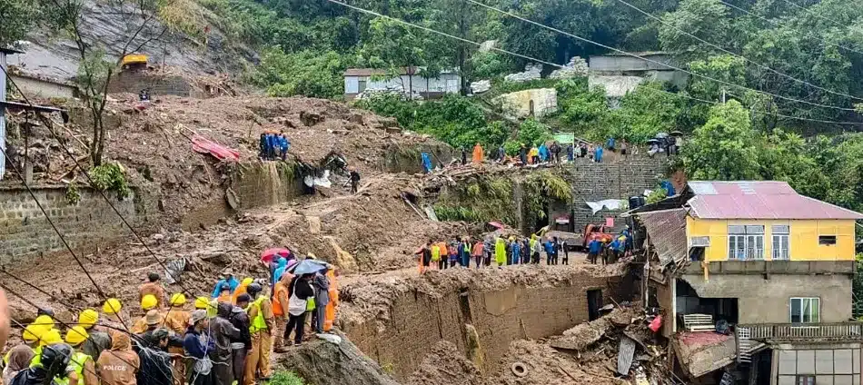
Why in News?
Six people were killed in West Bengal in incidents triggered by cyclone Remal that struck the coastline recently. In Northeast, heavy rain caused by the cyclone triggered landslides in several places in Meghalaya, Mizoram, Assam, and Nagaland, which have resulted in the deaths of at least 30 people so far.
Almost the entire region, including Sikkim and northern West Bengal, is landslide prone. Cyclone-triggered landslides have hit Northeastern states on earlier occasions as well. Cyclone Aila had caused landslide events in this region in May 2009.
What is landslide and what are the factors responsible for it?
- A landslide is defined as the movement of a mass of rock, debris, or earth down a slope.
- Landslides are a type of “mass wasting,” which denotes any down-slope movement of soil and rock under the direct influence of gravity.
- Landslides occur mainly in mountainous terrains where there are conducive conditions of soil, rock, geology and slope.
- Natural Causes that trigger it include heavy rainfall, earthquakes, snow melting and undercutting of slopes due to flooding.
- Landslides can also be caused by Anthropogenic Activities such as excavation, cutting of hills and trees, excessive infrastructure development, and overgrazing by cattle.
- In India, rainfall-induced landslide events are more common.
Classification and mapping of landslides
- Landslides are broadly classified based on the –
Landslide vulnerability of India
- According to the Geological Survey of India (GSI), about 0.42 million square km of India’s landmass, or about 13% of its area, spread over 15 states and four Union Territories.
- This covers almost all the hilly regions in the country. About 0.18 million square km, or 42% of this vulnerable area is in the Northeastern region, where the terrain is mostly hilly.

Steps taken by India to deal with landslides
- NDMA is working with GSI
- The National Disaster Management Authority (NDMA) has been working with GSI and other agencies to mitigate and manage the risks from landslides.
- National Landslide Risk Management Strategy finalized
- A National Landslide Risk Management Strategy was finalised in 2019.
- This strategy talked about vulnerability mapping, identifying the most vulnerable locations, development of an early warning system, and preparation of mountain zone regulations.
- Early warning
- Some early warning systems have been developed and deployed on a trial basis at a few locations.
- These warning systems are linked to rainfall forecasts from IMD.
- The rainfall prediction is combined with soil and terrain information to calculate whether it is likely to result in displacement of land.
- Since earthquakes themselves cannot be predicted, building landslide early warning based on earthquakes can be difficult.
- But rainfall-based early warning systems for landslides seem to work well.
Way forward
- Need to factor in the carrying capacity of mountains
- The risk from landslides has been exacerbated by the failure to remain mindful of the terrain’s ability to withstand the load.
- Many hilly areas do not have building regulations. Often, regulations are not implemented effectively.
- New constructions, infrastructure development, and even agricultural practices can increase the risk of landslides.
- Need for building resilience to multi-hazard disasters
- There is need for building resilience to multi-hazard disasters. One event can trigger another, and can lead to multiple disasters simultaneously.
- Over the last few years, India has witnessed events in which heavy rainfall has resulted in a breach of glacial lakes, causing flash floods that have resulted in landslides and flooding.
Q.1. What is Geological Survey of India (GSI)?
The Geological Survey of India (GSI) is a scientific agency under the Ministry of Mines, Government of India. Established in 1851, its primary function is to conduct geological surveys and studies of India to assess mineral resources. GSI is responsible for creating and updating geological maps, exploring and assessing mineral deposits, and conducting geoscientific research.
Q.2. What is National Disaster Management Authority (NDMA)?
The National Disaster Management Authority (NDMA) is the apex body in India responsible for formulating policies, plans, and guidelines for disaster management. Established under the Disaster Management Act, 2005, NDMA’s primary objective is to coordinate and implement a comprehensive disaster management framework to reduce the impact of disasters.
Source: Explained: Danger from landslides | Indian Express | Hindustan Times | NDTV


Last updated on August, 2025
→ UPSC Mains Admit Card 2025 has been released on 14th August at www.upsc.gov.in.
→ UPSC Mains 2025 will be conducted on 22nd August 2025.
→ UPSC Notification 2025 was released on 22nd January 2025.
→ UPSC Calendar 2026 is released on 15th May, 2025.
→ UPSC Prelims Question Paper 2025 and Unofficial Prelims Answer Key 2025 are available now.
→ UPSC Prelims Result 2025 is out now for the CSE held on 25 May 2025.
→ The UPSC Vacancy 2025 were released 1129, out of which 979 were for UPSC CSE and remaining 150 are for UPSC IFoS.
→ UPSC Prelims 2026 will be conducted on 24th May, 2026 & UPSC Mains 2026 will be conducted on 21st August 2026.
→ The UPSC Selection Process is of 3 stages-Prelims, Mains and Interview.
→ UPSC Result 2024 is released with latest UPSC Marksheet 2024. Check Now!
→ UPSC Toppers List 2024 is released now. Shakti Dubey is UPSC AIR 1 2024 Topper.
→ Also check Best IAS Coaching in Delhi