
What’s in today’s article?
- Why in News?
- How a Tropical Cyclone is Formed?
- Characteristics of a Tropical Cyclone
- How are Cyclones Classified?
- How are Tropical Cyclones Named?
- About WMO/ESCAP Panel
- News Summary
- About IMD
Why in News?
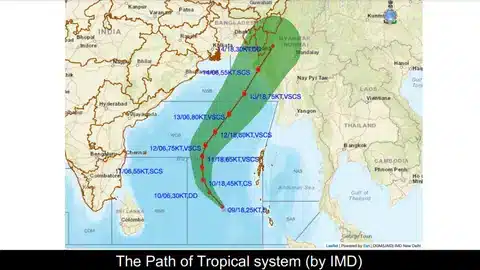
- A cyclone, which is most likely to swerve away from the Indian coast, is all set to develop over the southeast Bay of Bengal, the India Meteorological Department (IMD) said.
- Once intensified, it is to be identified as ‘Cyclone Mocha’ (pronounced as Mokha), a name suggested by Yemen.
How a Tropical Cyclone is Formed?
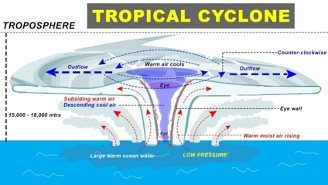
Image Caption: Tropical Cyclone
- Tropical Cyclone is a weather phenomenon.
- A tropical cyclone is formed only over warm ocean waters near the equator.
- Warm, moist air rises up and away from the ocean surface, creating an area of low pressure.
- It causes the air from surrounding areas with higher pressure to move towards the low-pressure area.
- This leads to warming up of air and causes it to rise above.
- As the air rises & cools, the water in the air forms clouds.
- This complete system of clouds and wind spins & grows, along with the ocean’s heat.
- As the wind rotation speed increases, an eye gets formed in the middle.


Characteristics of a Tropical Cyclone
- The centre of a cyclone is very calm and clear with very low air pressure.
- The average speed is 120 kmph.
- They have closed isobars which leads to greater velocity.
- Isobars are imaginary lines on a weather map that connect locations with equal atmospheric pressure.
- They develop over oceans and sea only.
- They move from east to west under the influence of trade winds.
- They are seasonal in nature.
How are Cyclones Classified?
- Cyclones are classified on the basis of wind speed by the Indian Meteorological Department (IMD):
- Depression: Wind speeds of between 31–49 km/h
- Deep Depression: Between 50-61 km/h
- Cyclonic Storm: Between 62–88 km/h
- Severe Cyclonic Storm: Between 89-117 Km/h
- Very Severe Cyclonic Storm: Between 118-166 Km/h
- Extremely Severe Cyclonic Storm: Between 166-221 Km/h
- Super Cyclonic Storm: Above 222 Km/h
How are Tropical Cyclones Named?
- There are five tropical cyclone regional bodies in the world:
- ESCAP/WMO Typhoon Committee,
- WMO/ESCAP Panel on Tropical Cyclones,
- RA I Tropical Cyclone Committee,
- RA IV Hurricane Committee,
- RA V Tropical Cyclone Committee.
- WMO/ESCAP Panel on Tropical Cyclones is responsible for naming of cyclones in the Indian Ocean.
About WMO/ESCAP Panel
- It is an inter-governmental regional body jointly established by the World Meteorological Organization (WMO) and the United Nations Economic and Social Commission for Asia-Pacific (ESCAP) in 1972.
- Objective:
- To promote measures to improve tropical cyclone warning systems in the Bay of Bengal and the Arabian Sea region.
- It comprises of thirteen countries in the region – Bangladesh, India, Iran, Maldives, Myanmar, Oman, Pakistan, Qatar, Saudi Arabia, Sri Lanka, Thailand, United Arab Emirates, Yemen.
- They contribute to a set of names which are assigned sequentially whenever a cyclonic storm develops.
News Summary
- Indian Meteorological Department has warned that Cyclone Mocha forming over the Bay of Bengal may intensify into a very severe storm.
- According to the IMD, a low-pressure area has already formed over the southeast Bay of Bengal and adjoining South Andaman Sea.
- This will be the first cyclonic storm of the year.
- India has dual cyclone seasons – pre-monsoon (April-June) and post-monsoon (October-December).
- Of these, the most cyclone-prone months are May and November.
- Last May, around the same time, severe cyclone Asani came close to the Andhra Pradesh coast causing significant rainfall and gusting winds.
·
About IMD
- India Meteorological Department was established in 1875.
- It is the National Meteorological Service of the country and the principal government agency in all matters relating to meteorology and allied subjects.
- Concerned Ministry: Ministry of Earth Sciences
- Headquarters: New Delhi
Functions of IMD:
- To take meteorological observations and to provide current and forecast meteorological information for optimum operation of weather-sensitive activities like agriculture, irrigation, shipping, aviation, offshore oil explorations, etc.
- To warn against severe weather phenomena like tropical cyclones, norwesters, dust storms, heavy rains and snow, cold and heat waves, etc., which cause destruction of life and property.
- To provide meteorological statistics required for agriculture, water resource management, industries, oil exploration and other nation-building activities.
Q1) What is the basic difference between cyclone and anti-cyclone?
A cyclone is a low pressure system and an anti-cyclone is a high pressure system.
Q2) Why do cyclones form in the sea?
Warm, moist air over the ocean rises due to less density. This air rises up and away from the ocean surface, leaving less air near the surface, creating a low-pressure zone. Due to the surrounding high-pressure areas, air flows into this low-pressure area and eventually warms up, forming a cycle.
Source: Cyclone Mocha likely to develop over Bay of Bengal today: IMD | HT
Last updated on December, 2025
→ Check out the latest UPSC Syllabus 2026 here.
→ Join Vajiram & Ravi’s Interview Guidance Programme for expert help to crack your final UPSC stage.
→ UPSC Mains Result 2025 is now out.
→ UPSC Notification 2026 is scheduled to be released on January 14, 2026.
→ UPSC Calendar 2026 is released on 15th May, 2025.
→ The UPSC Vacancy 2025 were released 1129, out of which 979 were for UPSC CSE and remaining 150 are for UPSC IFoS.
→ UPSC Prelims 2026 will be conducted on 24th May, 2026 & UPSC Mains 2026 will be conducted on 21st August 2026.
→ The UPSC Selection Process is of 3 stages-Prelims, Mains and Interview.
→ UPSC Result 2024 is released with latest UPSC Marksheet 2024. Check Now!
→ UPSC Prelims Result 2025 is out now for the CSE held on 25 May 2025.
→ UPSC Toppers List 2024 is released now. Shakti Dubey is UPSC AIR 1 2024 Topper.
→ UPSC Prelims Question Paper 2025 and Unofficial Prelims Answer Key 2025 are available now.
→ UPSC Mains Question Paper 2025 is out for Essay, GS 1, 2, 3 & GS 4.
→ UPSC Mains Indian Language Question Paper 2025 is now out.
→ UPSC Mains Optional Question Paper 2025 is now out.
→ Also check Best IAS Coaching in Delhi