What’s in today’s article?
- Why in news?
- What is a Hurricane?
- Key characteristics of hurricanes
- News Summary: What makes Hurricane Hilary ‘unprecedented’
- Why is this so rare?
- So, is climate change the culprit?
Why in news?
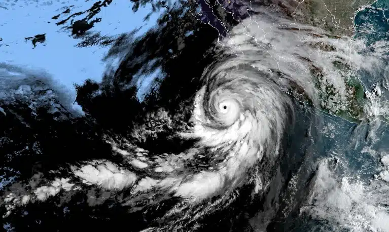
- Hurricane Hilary is set to become the first tropical storm to hit the Southern California in more than 80 years.
- As per the country’s National Weather Service (NWS), in an average 3-year period, roughly five hurricanes strike the US coastline – but never in the west coast.
- This is why Hurricane Hilary, which is currently racing towards Southern California and Mexico, is so out of the ordinary.
What is a Hurricane?
- A hurricane is a powerful and destructive tropical storm characterized by strong winds, heavy rainfall, and low atmospheric pressure.
- Hurricanes are also known as cyclones or typhoons in different parts of the world; the term used depends on the region.
- In the Atlantic Ocean and eastern North Pacific, they are called hurricanes, while in the northwestern Pacific, they are referred to as typhoons, and in the South Pacific and Indian Ocean, they are known as cyclones.
Key characteristics of hurricanes
- Low Pressure Centre
- Hurricanes have a well-defined centre of low atmospheric pressure, known as the eye.
- The eye is typically calm and clear, with light winds, surrounded by a ring of intense thunderstorms called the eyewall.
- Strong Winds
- Hurricanes are known for their powerful winds that can reach sustained speeds of at least 74 miles per hour (119 kilometers per hour) or higher.
- Heavy Rainfall
- Hurricanes produce heavy rainfall, which can lead to flooding, landslides, and storm surges (a rise in sea level along the coast caused by the hurricane’s winds pushing water toward the shore).
- Formation
- Hurricanes form over warm ocean waters when the sea surface temperature is typically above 26 degrees Celsius (79 degrees Fahrenheit).
- Warm, moist air rises from the ocean’s surface, creating an area of low pressure.
- As the air cools and condenses, it releases heat, which fuels the storm’s development.
- Categories
- Hurricanes are categorized on the Saffir-Simpson Hurricane Wind Scale based on their maximum sustained wind speeds.
- The scale ranges from Category 1 (weakest) to Category 5 (strongest), with each category representing a higher wind speed and potential for damage.
News Summary: What makes Hurricane Hilary ‘unprecedented’
- As per the recent public advisory issued by the US National Hurricane Centre, the storm was very near the west coast of Baja California.
- Baja California – The long Mexican peninsula bound by the Gulf of California in the east and the North Pacific Ocean in the west.

Image caption: Baja California
- This is extraordinary as the only tropical storm with hurricane-force winds believed to have hit Southern California came in October 1858, with San Diego bearing its brunt.
Why this is so rare?
- Nature of the ocean
- The primary reason why the Pacific coast seldom sees such tropical storms and hurricanes is the nature of the ocean itself.
- The first condition for the formation of hurricanes is that ocean waters must be above 26 degrees Celsius.
- Below this threshold temperature, hurricanes will not form or will weaken rapidly once they move over water below this threshold.
- While high temperatures are common during hurricane season along the US east coast, the west coast is much colder.
- In the Atlantic, warm, equatorial waters are transported north to higher latitudes along the US coast via the Gulf Stream.
- However, along the west coast, in the Pacific, cold current steers colder water from higher latitudes toward equatorial regions.
- This makes hurricanes highly unlikely.
- Vertical wind shear
- It is the change in wind speed as one travels up from the Earth’s surface — especially in the upper level of the atmosphere.
- It is an important ingredient in formation of hurricanes as they can extend up to 16 km into the atmosphere.
- Hurricanes cannot emerge if the upper-level winds are strong.
- This is because they destroy the storms structure by displacing the warm temperatures above the eye and limiting the vertical accent of air parcels.
- Usually, wind shear in the eastern Pacific is much stronger than the Gulf of Mexico, causing less frequent hurricanes along the western coast.
- Influence of wind steering patterns
- Trade winds play a crucial role in directing hurricanes towards the east coast.
- The same winds divert them away from the west coast.
- Hurricanes originating in the eastern Pacific, often near the central Mexico coastline, generally follow a west-northwest trajectory that take them away from the coast.
So, is climate change the culprit?
- Scientists expected climate change to not only spike the occurrence of such hurricanes, but also make them more intense.
- This is due to the rise of the surface temperatures of the oceans.
- The oceans are known to have absorbed 90 per cent of the additional heat generated by the greenhouse gas emissions in recent years.
- Due to this, global mean sea surface temperature has gone up by close to 0.9 degree Celsius since 1850 and around 0.6 degree Celsius over the last four decades.
- Higher sea surface temperatures cause marine heat waves, an extreme weather event, which can also make storms like hurricanes and tropical cyclones more intense.
- Warmer temperatures escalate the rate of evaporation along with the transfer of heat from the oceans to the air.
- When storms travel across hot oceans, they gather more water vapour and heat. This results in stronger winds, heavier rainfall and more flooding when storms reach the land.
- The situation has been worsened by the El Nino, developing for the first time in seven years.
- El Nino is a weather pattern that refers to an abnormal warming of surface waters in the equatorial Pacific Ocean.
- This has weakened the vertical wind shear in the eastern Pacific, allowing more hurricanes in the region.
Q1) What is El Nino?
El Niño is a climate phenomenon characterized by the periodic warming of sea surface temperatures in the central and eastern equatorial Pacific Ocean. This event typically occurs every two to seven years and has significant impacts on weather patterns and climate around the world.

Q2) What are marine heat waves?
Marine heatwaves are extended periods of anomalously warm sea surface temperatures in the ocean. Just like heat waves on land, which are characterized by prolonged periods of abnormally high temperatures, marine heatwaves represent periods of exceptionally warm water temperatures in the ocean.
Source: What makes Hurricane Hilary ‘unprecedented’ | Economic Times | CBS News
Last updated on July, 2025
→ UPSC Notification 2025 was released on 22nd January 2025.
→ UPSC Prelims Result 2025 is out now for the CSE held on 25 May 2025.
→ UPSC Prelims Question Paper 2025 and Unofficial Prelims Answer Key 2025 are available now.
→ UPSC Calendar 2026 is released on 15th May, 2025.
→ The UPSC Vacancy 2025 were released 1129, out of which 979 were for UPSC CSE and remaining 150 are for UPSC IFoS.
→ UPSC Mains 2025 will be conducted on 22nd August 2025.
→ UPSC Prelims 2026 will be conducted on 24th May, 2026 & UPSC Mains 2026 will be conducted on 21st August 2026.
→ The UPSC Selection Process is of 3 stages-Prelims, Mains and Interview.
→ UPSC Result 2024 is released with latest UPSC Marksheet 2024. Check Now!
→ UPSC Toppers List 2024 is released now. Shakti Dubey is UPSC AIR 1 2024 Topper.
→ Also check Best IAS Coaching in Delhi