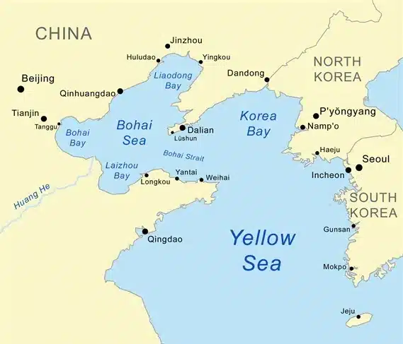
About Bohai Gulf:
- It is the innermost gulf of the Yellow Sea on the coast of Northeastern and North China.
- It is sometimes called Bohai Sea, or Bo Hai for short; in earlier times it was called theGulf of Chili or the Gulf of Pechili.
- It is approximately 78,000 sq.km in area, and its proximity to Beijing, the capital of China, makes it one of the busiest seaways in the world.
- The Bohai Gulf is enclosed by the Liaodong Peninsula (northeast) and the Shandong Peninsula (south).
- Among the most important cities on the Bohai Gulf are Dalian and Tianjin; its shoresform three of the most famous bays in the country: Liaodong Bay, Bohai Bay, and Laizhou Bay.
- The Yellow River, China’s second longest river, discharges into the gulf.
- There are both onshore and offshore petroleum deposits, and several oil refineries are located there as well as other industries.
Key Facts about Yellow Sea:
- It is a marginal sea of the western Pacific Ocean.
- Location:
- It is situated between mainland Chinato the west and north, the Korean Peninsula to the east, and the Shandong Peninsula and Liaodong Peninsula to the south.
- It connects with the Bohai Sea to the northwest.
- Size: Also referred to in China as Huang Hai and in North and South Korea as the West Sea, the Yellow Sea is 870 kilometres long and 556 kilometres wide.
- Depth: It is one of the largest shallow areas of continental shelf in the world, with an average depth of 44 metres and a maximum depth of 152 metres.
- Inflow: Several major rivers, including the Yellow River and the Yangtze River, discharge into the Yellow Sea.
- Islands: The Yellow Sea is dotted with numerous islands, the largest of which include Jeju Island (South Korea), the Shandong Peninsula islands (China), and Ganghwa Island (South Korea).
- Climate: The climate is characterized by very cold, dry winters and wet, warm summers.
- Currents:
- The warm current of the Yellow Sea is a part of the Tsushima Current, which diverges near the western part of the Japanese island of Kyushu and flows at less than 0.5 mile (0.8 km) per hour northward into the middle of the sea.
- Along the continental coasts, southward-flowing currents prevail, which strengthen markedly in the winter monsoon period, when the water is cold, turbid, and of low salinity.
Q1: What is a Gulf?
The Gulf is a portion of the sea that is almost surrounded by land except one narrow opening. Gulfs are formed when a giant rock collapses or when a piece of land sinks. This causes a big indentation in the area, and the water eventually fills it up. Gulfs are also formed through a natural process of erosion.
Source: New Chinese Migratory Bird Sanctuaries Added To UNESCO World Heritage List


Last updated on June, 2025
→ UPSC Notification 2025 was released on 22nd January 2025.
→ UPSC Prelims Result 2025 is out now for the CSE held on 25 May 2025.
→ UPSC Prelims Question Paper 2025 and Unofficial Prelims Answer Key 2025 are available now.
→ UPSC Calendar 2026 is released on 15th May, 2025.
→ The UPSC Vacancy 2025 were released 1129, out of which 979 were for UPSC CSE and remaining 150 are for UPSC IFoS.
→ UPSC Mains 2025 will be conducted on 22nd August 2025.
→ UPSC Prelims 2026 will be conducted on 24th May, 2026 & UPSC Mains 2026 will be conducted on 21st August 2026.
→ The UPSC Selection Process is of 3 stages-Prelims, Mains and Interview.
→ UPSC Result 2024 is released with latest UPSC Marksheet 2024. Check Now!
→ UPSC Toppers List 2024 is released now. Shakti Dubey is UPSC AIR 1 2024 Topper.
→ Also check Best IAS Coaching in Delhi