About the Great Nicobar Project:
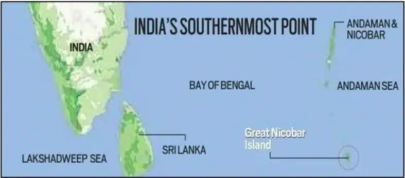
- The Great Nicobar Project is a multi-development initiative aimed at the holistic development of Great Nicobar Island, a strategic location in the southern end of the Andaman and Nicobar Islands.
- It was cleared by the Ministry of Environment in November 2022 and is part of a broader strategy to enhance India’s strategic presence and infrastructure in the region.
- The project is expected to be developed over 30 years in a phased manner.
Key objectives:
- Strategic importance: The project is designed to counter expansionist activities by neighbouring countries, particularly China, and to safeguard India’s maritime interests by curbing illegal activities like poaching by Myanmarese fishers.
- Infrastructure development: The project is valued at ₹72,000 crore and includes key infrastructure such as the development of an international container trans-shipment terminal, a greenfield international airport with dual military-civilian functions, township development, and a 450 MVA power plant (gas and solar-based).
Geographical context:
- Location: Great Nicobar Island is the southernmost island in the Andaman and Nicobar group, separated from the Andaman Islands by the Ten Degree Channel.
- It is also home to Indira Point, India’s southernmost point, located less than 150 km from Indonesia.
- Ecosystem: The island features tropical wet evergreen forests, mountain ranges up to 650 meters high, and coastal plains.
- It also houses two national parks and a biosphere reserve, supporting endangered species like the leatherback sea turtle.
Impact on Indigenous Tribes:
- Tribal population: The island is home to the Shompen, a hunter-gatherer tribe, and the Nicobarese. An estimated 237 Shompen and 1,094 Nicobarese live in a tribal reserve covering 751 sq km, of which 84 sq km is proposed to be denotified for the project.
Environmental and seismic considerations:
- Deforestation: Approximately 13,075 hectares of forest land, or about 15% of the island’s area, is slated for diversion, with nearly 9.64 lakh trees expected to be felled.
- Seismic risks: The region is seismically active, having experienced a major earthquake (9.2 on the Richter scale) in 2004.
- Experts suggest a similar event may not occur for another 400-750 years, though smaller quakes are anticipated.
- The project will adhere to the National Building Code for earthquake-resistant structures.
Q1. What is a Coral reef?
A coral reef is a diverse underwater ecosystem characterized by reef-building corals. These reefs are formed from the calcium carbonate skeletons of coral polyps, tiny marine animals. Coral reefs are often called the “rainforests of the sea” because of their rich biodiversity.
Last updated on June, 2025
→ UPSC Notification 2025 was released on 22nd January 2025.
→ UPSC Prelims Result 2025 is out now for the CSE held on 25 May 2025.
→ UPSC Prelims Question Paper 2025 and Unofficial Prelims Answer Key 2025 are available now.
→ UPSC Calendar 2026 is released on 15th May, 2025.
→ The UPSC Vacancy 2025 were released 1129, out of which 979 were for UPSC CSE and remaining 150 are for UPSC IFoS.
→ UPSC Mains 2025 will be conducted on 22nd August 2025.
→ UPSC Prelims 2026 will be conducted on 24th May, 2026 & UPSC Mains 2026 will be conducted on 21st August 2026.
→ The UPSC Selection Process is of 3 stages-Prelims, Mains and Interview.
→ UPSC Result 2024 is released with latest UPSC Marksheet 2024. Check Now!
→ UPSC Toppers List 2024 is released now. Shakti Dubey is UPSC AIR 1 2024 Topper.
→ Also check Best IAS Coaching in Delhi


