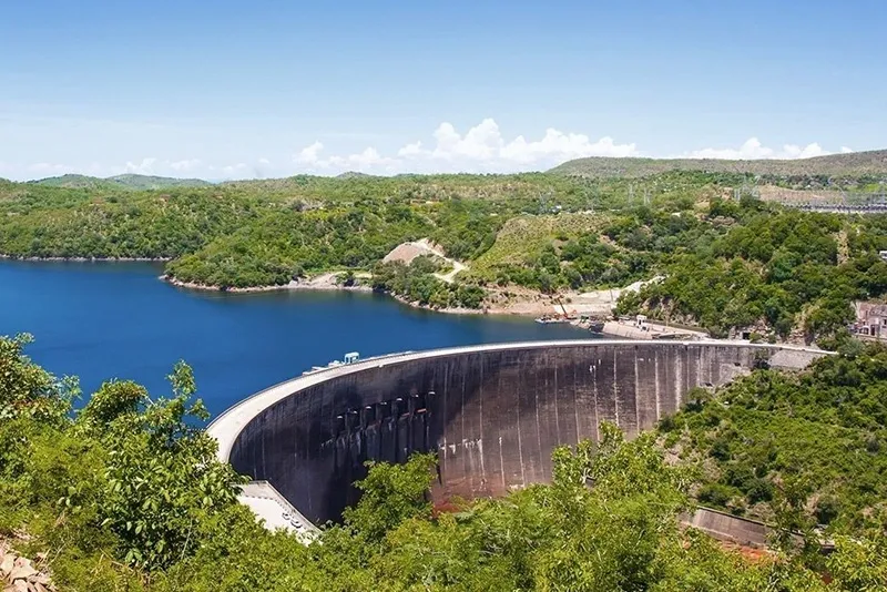
About Lake Kariba:
- It is a lake in central Africa, along the border between Zambia and Zimbabwe.
- It is positioned 810 miles upstream from the Indian Ocean.
- It is the world’s largest man-made lake. It covers an area of 2,000 square miles (5,200 square km).
- It was formed by damming the Zambezi River in the Kariba Gorge, where the river narrows between hills of hard rock 250 miles (400 km) below Victoria Falls.
- The Kariba Dam consists of a double-arch wall. It is 128 meters in height, 617 meters in length, 13 meters wide at its top, and 24 meters wide at the base.
- It provides considerable electric power to both Zambia and Zimbabwe and supports a thriving commercial fishing industry.
- The lake encompasses a total of 102 islands, including well-known ones like Chete Island and Spurwing Island.
- The Chete Island boasts the world’s largest expanse of protected, undeveloped wetlands and hosts the largest single population of African elephants.
Q1: What is an Arch Dam?
Arch dams are curved in plan, and most of their water load is carried by the abutment of the arch horizontally. The amount of water load it can withstand is determined by its arch or curvature.
Source: ‘Levels are dropping’: drought saps Zambia and Zimbabwe of hydropower


Last updated on June, 2025
→ UPSC Notification 2025 was released on 22nd January 2025.
→ UPSC Prelims Result 2025 will be out soon for the CSE held on 25 May 2025.
→ UPSC Prelims Question Paper 2025 and Unofficial Prelims Answer Key 2025 are available now.
→ UPSC Calendar 2026 is released on 15th May, 2025.
→ The UPSC Vacancy 2025 were released 1129, out of which 979 were for UPSC CSE and remaining 150 are for UPSC IFoS.
→ UPSC Mains 2025 will be conducted on 22nd August 2025.
→ UPSC Prelims 2026 will be conducted on 24th May, 2026 & UPSC Mains 2026 will be conducted on 21st August 2026.
→ The UPSC Selection Process is of 3 stages-Prelims, Mains and Interview.
→ UPSC Result 2024 is released with latest UPSC Marksheet 2024. Check Now!
→ UPSC Toppers List 2024 is released now. Shakti Dubey is UPSC AIR 1 2024 Topper.
→ Also check Best IAS Coaching in Delhi