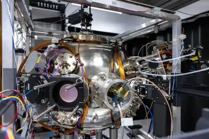
About Quantum Navigation:
- Where satellite navigation relies on the signal bouncing back from space, quantum navigation focuses on the movement of a single atom tracked under cryogenic conditions.
- Instead of a satellite floating in space, a quantum navigation system is within each individual vehicle, with measurements being made “at point of use”.
- This means the signal “doesn’t drift”, making interception much harder to achieve.
- Global navigation satellite systems (GNSS) like GPS are susceptible to accidental and deliberate outages, whereas quantum navigation is ‘unjammable’.
- But quantum navigation systems are unlikely to replace GNSSs any time soon.
- This is because, ultra-cold atoms are needed to achieve quantum navigation, and the equipment is currently sizable.
What is GPS?
- The Global Positioning System (GPS) is a space-based radio-navigation system consisting of a constellation of satellites broadcasting navigation signals and a network of ground stations and satellite control stations used for monitoring and control.
- Currently, 31 GPS satellites orbit the Earth at an altitude of approximately 11,000 miles, providing users with accurate information on position, velocity, and time anywhere in the world and in all weather conditions.
- It is operated and maintained by the U.S. Department of Defense (USDOD).
- The USDOD originally put the satellites into orbit for military use, but they were made available for civilian use in the 1980s.
- GPS works in any weather conditions, anywhere in the world, 24 hours a day, with no subscription fees or setup charges.
- How GPS Works?
- GPS satellites circle the Earth twice a day in a precise orbit.
- Each satellite transmits a unique signal and orbital parameters that allow GPS devices to decode and compute the precise location of the satellite.
- GPS receivers use this information and trilateration to calculate a user’s exact location.
- Essentially, the GPS receiver measures the distance to each satellite by the amount of time it takes to receive a transmitted signal.
- With distance measurements from a few more satellites, the receiver can determine a user’s position and display it electronically.
Q1: What is Navigation with Indian Constellation (NaVIC)?
NaVIC or the Indian Regional Navigation Satellite System (IRNSS) uses seven satellites to provide real-time positioning and timing services in India and an area extending up to 1,500 km from the country’s borders. Of the seven satellites used by NaVIC at present, three are in the geostationary orbit and four in the geosynchronous orbit.
Source: What’s quantum navigation? It could even replace GPS


Last updated on June, 2025
→ UPSC Notification 2025 was released on 22nd January 2025.
→ UPSC Prelims Result 2025 is out now for the CSE held on 25 May 2025.
→ UPSC Prelims Question Paper 2025 and Unofficial Prelims Answer Key 2025 are available now.
→ UPSC Calendar 2026 is released on 15th May, 2025.
→ The UPSC Vacancy 2025 were released 1129, out of which 979 were for UPSC CSE and remaining 150 are for UPSC IFoS.
→ UPSC Mains 2025 will be conducted on 22nd August 2025.
→ UPSC Prelims 2026 will be conducted on 24th May, 2026 & UPSC Mains 2026 will be conducted on 21st August 2026.
→ The UPSC Selection Process is of 3 stages-Prelims, Mains and Interview.
→ UPSC Result 2024 is released with latest UPSC Marksheet 2024. Check Now!
→ UPSC Toppers List 2024 is released now. Shakti Dubey is UPSC AIR 1 2024 Topper.
→ Also check Best IAS Coaching in Delhi