The Narmada River System, also known as the Reva, is one of the major west-flowing river systems of Peninsular India. The Narmada is the fifth-longest river in India and the country’s longest west-flowing river. Unlike most peninsular rivers that drain into the Bay of Bengal, it flows from east to west through a unique tectonic rift valley before draining into the Arabian Sea through the Gulf of Khambhat.
Originating near Amarkantak in Madhya Pradesh, the river flows for about 1,312 km between the Vindhya Range in the north and Satpura Range in the south. The Narmada River System supports irrigation, hydropower, drinking-water supply, agriculture and industries, while major projects such as Sardar Sarovar have enhanced its regional significance.
Narmada River System Origin
The Narmada River is the largest west-flowing river in peninsular India and is a major river under the Peninsular River System.
- Originating from the Maikala range near Amarkantak in Madhya Pradesh at an elevation of approximately 1,057 metres, it flows westward through a rift valley formed between the Vindhya Range to the north and the Satpura Range to the south.
- The river spans a total length of 1,312 kilometres before emptying into the Gulf of Khambhat.
Narmada River System Map
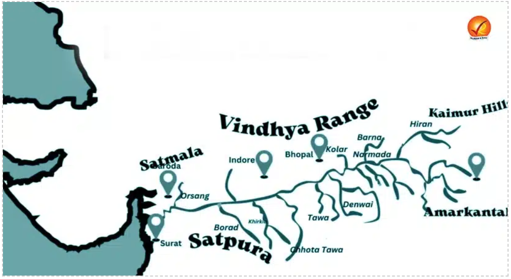
The Narmada River System Map offers a detailed geographical overview of one of India’s most significant west-flowing rivers. Originating from Central India, the Narmada Valley forms an important physiographic divide between the Vindhya and Satpura ranges and has distinctive geographical characteristics.


Narmada River System Tributaries
The Narmada River has several important tributaries on both its right and left banks. These tributaries contribute to the river’s flow, aiding in irrigation, hydropower generation, and ecological balance.
- Among these tributaries, the Tawa River is the largest left-bank tributary and is crucial for irrigation and water supply in Madhya Pradesh.
- The Orsang River, a right-bank tributary, plays a significant role in Gujarat.
- These tributaries collectively support the Narmada River in sustaining agriculture, hydroelectric projects, and local biodiversity.
Right Bank Tributaries of the Narmada River
- Barna River
- Hiran River
- Tendoni River
- Choral River
- Kolar River
- Man River
- Uri River
- Hatni River
- Orsang River
Left Bank Tributaries of the Narmada River
- Burhner River
- Banjar River
- Sher River
- Shakkar River
- Dudhi River
- Tawa River (largest left-bank tributary)
- Ganjal River
- Chhota Tawa River
- Kaveri River
- Kundi River
- Goi River
- Karjan River
Narmada River System Basin
The Narmada River System Basin is one of India's most critical hydrological networks, governing the ecological and economic lifecycle of central and western India.
- The Narmada River Basin covers an area of approximately 98,796 square kilometres, accounting for over 3% of India's total geographical area.
- It originates from Amarkantak in Madhya Pradesh and flows westward for 1,312 kilometres before draining into the Arabian Sea.
- The basin is bounded by the Vindhya Range to the north, Satpura Range to the south and the Maikal region towards the east, while it opens westward towards the Gulf of Khambhat and the Arabian Sea.
- It spans Madhya Pradesh, Gujarat, and small portions of Maharashtra and Chhattisgarh.
- The upper basin is characterised by hilly and forested terrain, while the middle and lower reaches include broader valley plains and alluvial areas supporting agriculture.
- The river plays a crucial role in supporting irrigation, drinking water supply, and industrial activities.
- Unlike many major east-flowing Peninsular rivers, the Narmada forms an estuarine outlet rather than a large delta, owing to its westward drainage, coastal setting, tidal influence and geomorphological conditions.
- Major hydropower projects on the river include the Sardar Sarovar Dam, Indira Sagar Dam, and Omkareshwar Dam.
- The river is also famous for natural attractions such as the Dhuandhar Falls and the Marble Rocks near Jabalpur.
Narmada River System Major Dams and Projects
Major Narmada projects have been developed for irrigation, hydropower, drinking-water supply and regulated water distribution across the basin and command areas.
- Sardar Sarovar Dam: The Sardar Sarovar Project is the most prominent multipurpose project on the Narmada River. Located in Gujarat, it provides water for irrigation, drinking-water supply and power generation.
- Its extensive canal network has enabled Narmada water to reach areas beyond the immediate river valley, particularly in Gujarat.
- Indira Sagar Project: The Indira Sagar Project is located in Madhya Pradesh and is an important reservoir-based project in the Narmada system.
- It has the largest reservoir storage capacity among completed reservoirs in India, according to NHPC.
- Omkareshwar Project: The Omkareshwar Project is another major multipurpose development on the Narmada in Madhya Pradesh, contributing to hydropower generation and water management.
- Maheshwar Project: The Maheshwar Project is associated with hydropower development on the Narmada in Madhya Pradesh.
- Its construction has faced prolonged delays and suspension due to financial, environmental and implementation-related issues.
Narmada River System Westward Course Geographical Reasons
The westward course of the Narmada is primarily controlled by the geological structure and relief of central India, rather than being a random drainage direction.
- Rift valley setting: The Narmada flows through a major tectonic trough or rift-like valley, which provides a natural structural pathway for its westward course.
- Narmada–Son Lineament: The river follows the Narmada–Son lineament, a major geological zone of weakness in Peninsular India. This structural control has strongly influenced the river's relatively straight course.
- Vindhya–Satpura alignment: The Narmada flows between the Vindhya Range in the north and Satpura Range in the south. These elevated ranges act as natural boundaries of the Narmada Valley and channel the river westward.
- Slope and gradient: The Narmada Valley has a general westward inclination, which, together with its structural setting, facilitates drainage towards the Arabian Sea.
- Faulting and tectonic movements: Geological faults and fractures associated with the Narmada Valley created a favourable pathway for river incision and drainage development.
- Arabian Sea outlet: The western side of the valley ultimately opens towards the Gulf of Khambhat, providing a natural outlet into the Arabian Sea.
- Contrast with other Peninsular rivers: Most major Peninsular rivers such as the Godavari, Krishna and Mahanadi generally follow the broader eastward slope towards the Bay of Bengal.
- The Narmada is an important exception because its course is strongly influenced by its structural valley.
Narmada River System Importance
The Narmada River system is important for irrigation, hydropower, drinking water, agriculture, industries, ecological resources and the socioeconomic development of central and western India.
- Irrigation: Narmada projects supply water to large agricultural command areas, particularly through extensive canal networks.
- Drinking water: Narmada water supports numerous villages and urban settlements, especially in Gujarat.
- Hydropower: Major projects generate electricity while regulating river flows.
- Agriculture: Irrigation from Narmada reservoirs and canals has expanded agricultural water availability in relatively water-stressed areas.
- Industrial development: Reliable water availability supports industrial and economic activities in the basin and command regions.
- Flood management: Reservoirs enable regulated storage and release of water, contributing to flood-management efforts.
- Ecological importance: The river supports aquatic ecosystems, wetlands, forests and associated biodiversity.
- Cultural significance: Places such as Omkareshwar and the Narmada's numerous pilgrimage centres give the river considerable religious and cultural importance.
- Tourism: Landscapes such as the Marble Rocks at Bhedaghat and river islands and gorges attract tourists.
Narmada River System Challenges
Challenges facing the Narmada include competing water demands, ecological degradation, pollution, altered river flows, climate variability, salinity concerns and pressure from intensive development.
- Competing water demands: Agriculture, drinking water, industry and ecological requirements compete for available river resources.
- Altered natural flows: Large reservoirs and water diversions can modify the river's natural flow regime.
- Ecological stress: Changes in flow and habitat conditions can affect aquatic ecosystems.
- Pollution: Urban, agricultural and industrial activities can affect water quality.
- Climate variability: Changes in rainfall and evaporation can influence reservoir inflows and water availability.
- Downstream salinity: Reduced freshwater flows towards the estuary can contribute to concerns over salinity intrusion in the lower reaches.
- Interstate management: Coordinating water allocation, reservoir operations and project development among the basin states remains important for sustainable utilisation.
- Large-project impacts: Major infrastructure can create social, ecological and land-use consequences that require careful planning.
Narmada River System Way Forward
The conservation of the Narmada requires integrated basin management that balances water security, ecological flows, pollution control, efficient irrigation and sustainable development. Important measures include:
- Maintain ecological flows to preserve downstream river and estuarine ecosystems.
- Improve irrigation efficiency and reduce avoidable water losses.
- Strengthen pollution control for urban and industrial wastewater.
- Protect wetlands and riverine habitats along the basin.
- Promote groundwater recharge to reduce excessive dependence on surface-water resources.
- Use real-time hydrological data for improved reservoir operation and flood management.
- Strengthen interstate coordination for equitable and sustainable water management.
- Adopt climate-resilient planning for changing rainfall and river-flow conditions.
- Balance development with conservation while planning future water-resource projects.
Narmada River System UPSC PYQs
Q1. The Narmada river flows to the west, while most other large peninsular rivers flow to the east. Why? (UPSC Prelims 2013)
- It occupies a linear rift valley.
- It flows between the Vindhyas and the Satpuras.
- The land slopes to the west from Central India.
Select the correct answer using the codes given below.
(a) 1 only
(b) 1 and 3 only
(c) 2 and 3 only
(d) None
Ans: (a)

 Last updated on Oct, 2026
→ UPSC 2027 Notification will be released on 13 January 2027 at upsconline.nic.in.
→ Check Nobel Prize 2026 Winners List here.
→ Download PIB PRiSM Monthly Magazine 2026 here.
→ Check UPSC Monthly Current Affairs Magazine The Recitals here.
→ Check out the latest UPSC Syllabus here.
→ Download UPSC Model Answers for Mains 2026
→ UPSC Mains Question Paper 2026 is out now for Essay & GS Paper 1, 2, 3 & 4.
→ UPSC Calendar 2027 has been released.
→ Enroll in Vajiram & Ravi’s UPSC Mains Test Series 2027 for structured answer writing practice, expert evaluation, and exam-oriented feedback.
→ Join Vajiram & Ravi’s UPSC Mentorship Program 2027 for personalized guidance, strategy planning, and one-to-one support from experienced mentors.
→ Go through the UPSC Mains Previous Year Papers to enhance your preparation.
→ UPSC has released UPSC Toppers List 2025 with the Civil Services final result on its official website.
→ Also check Best UPSC Coaching in India
Narmada River System FAQs
Q1. Where does Narmada start and end?+
Q2. How many tributaries does Narmada have?+
Q3. What is the real name of Narmada?+
Q4. Are crocodiles found in the Narmada River?+
Q5. Is Narmada older than Ganga?+
Tags: narmada river system