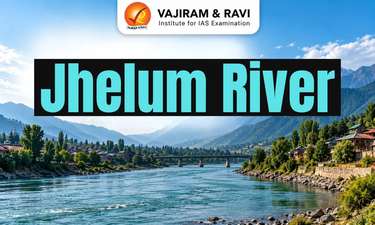
The Jhelum River is an important tributary of the Indus River system, originating at Verinag Spring in Jammu and Kashmir and flowing through the Kashmir Valley before entering Pakistan. Known as Vitasta in ancient Sanskrit tradition and Vyeth in Kashmiri, it holds considerable geographical, historical and cultural significance.
The Jhelum River receives water from mountain tributaries, including the Lidder, Sind and Kishanganga, and flows through Wular Lake, an important wetland ecosystem. Its waters support agriculture, hydropower, fisheries and settlements across the basin. However, flooding, riverbank erosion, pollution, sedimentation and wetland degradation threaten its ecological and economic value. Climate change may further influence rainfall, snowmelt and seasonal flows, highlighting the need for sustainable water management, ecosystem conservation and transboundary cooperation.
Jhelum River Origin
The Jhelum River originates at Verinag Spring in southeastern Kashmir Valley, emerging from the Himalayan foothills and flowing through a landscape shaped by mountains, wetlands and floodplains.
- The Verinag Spring, also known as Cheshma Verinag, is located near the foothills of the Pir Panjal Range in the southeastern part of the Kashmir Valley, in the Anantnag district of Jammu and Kashmir.
- The spring forms the headwaters of the Jhelum, one of the principal western tributaries of the Indus River system.
- Known as Vitasta in ancient Sanskrit tradition and Vyeth in Kashmiri, the river has played an important role in the geography, culture and settlement history of Kashmir. In classical Greek accounts, it was called the Hydaspes.
Jhelum River Location and Course
The Jhelum flows northwest through Kashmir Valley before crossing into Pakistan-administered territory and continuing through Pakistan’s Punjab region to join the Chenab River.
- From Verinag, the river passes through southern Kashmir, including the Anantnag region, and continues towards Srinagar. It receives water from mountain tributaries and flows through Wular Lake, an important natural feature of the Kashmir Valley.
- After passing Baramulla, the river cuts through a narrow gorge before continuing into Pakistan-administered territory.
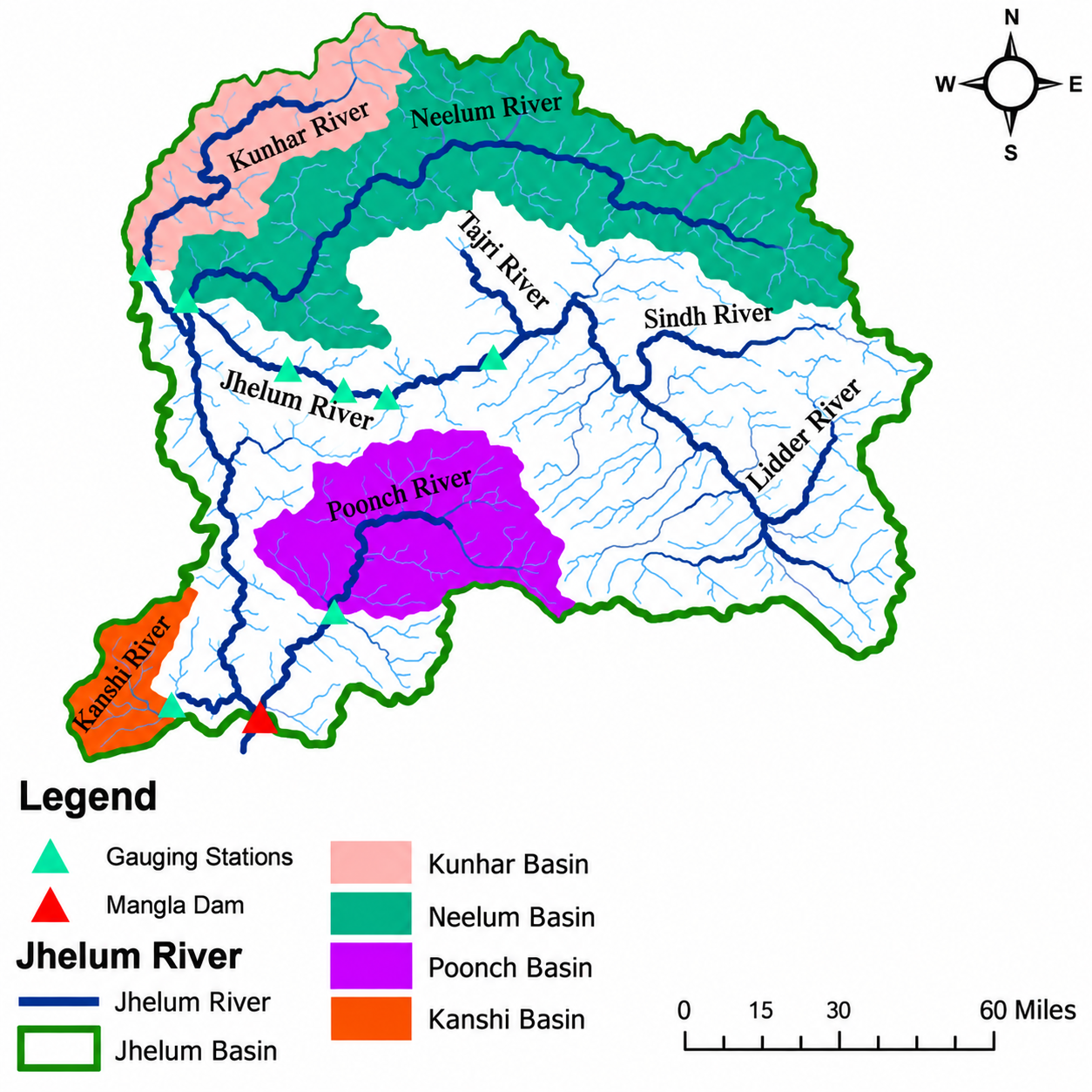
- Further downstream, the Jhelum receives tributaries such as the Neelum, also known as the Kishanganga, and the Kunhar.
- It then flows into the Mangla reservoir in Pakistan before continuing across the plains and joining the Chenab River near Trimmu. The Chenab subsequently forms part of the larger Indus River System.
- The Jhelum is therefore a transboundary river: its water resources, ecosystems and management are connected across political boundaries. Its importance extends from Kashmir’s mountain-fed valley to the agricultural regions downstream.
- The total length of the Jhelum River is approximately 725 km.


Jhelum River Hydrology
The Jhelum’s flow is influenced by mountain snowmelt, rainfall, tributary inflows and the natural storage capacity of lakes and floodplains throughout its drainage basin.
- The river is fed by both rainfall and snowmelt from the surrounding mountains. Its flow changes seasonally as snow melts in the warmer months and rainfall adds water to the river and its tributaries. Glacier-fed tributaries, including the Lidder, contribute to the river’s headwaters.
- As the Jhelum flows through the Kashmir Valley, its channel passes through a relatively broad valley floor before reaching the narrower gorge near Baramulla.
- The constricted outlet affects how floodwater leaves the valley. When river levels rise rapidly, water may spread over adjoining floodplains and built-up areas.
- Wular Lake also plays a hydrological role by receiving river water and providing natural storage. However, changes in lake conditions, sediment accumulation and floodplain development can influence the basin’s ability to accommodate high flows.
Jhelum River Major Tributaries
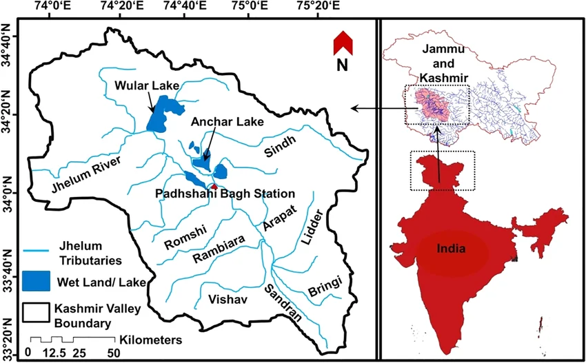
The Jhelum receives numerous tributaries from the surrounding mountain ranges, and their bank positions help explain how water enters the main channel across Kashmir Valley. The following classification follows its description of the river’s course up to and through the Kashmir Valley.
Right-Bank Tributaries of the Jhelum River
The right-bank tributaries of the Jhelum River are as below.
- Sandran River: Joins the Jhelum in its upper course before Anantnag.
- Bringi River: A mountain-fed tributary that contributes to the river’s upper catchment.
- Arapath River: Joins the Jhelum upstream of Anantnag.
- Lidder River: One of the major headwater tributaries, receiving water from high mountain areas and glaciers; it joins downstream of Khanabal.
- Watlara and Arapal streams: Smaller tributaries entering the Jhelum between Khanabal and Srinagar.
- The Sind River (Sindh Nallah): It flows through the Sonamarg region, the Sind Valley, and the Ganderbal district before joining the Jhelum at Shadipora.
- The Kishanganga River: A major tributary of the Jhelum River. It originates near Sonamarg in Jammu and Kashmir, flows through the Gurez Valley, and merges with the Jhelum River near Muzaffarabad.
- In Pakistan, it is also known as the Neelum River.
Left-Bank Tributaries of the Jhelum River
The left-bank tributaries of the Jhelum River are as below.
- Vishow (Veshaw) River: A significant tributary entering the Jhelum upstream of Sangam.
- Rambiara River: Drains the surrounding mountain catchment and contributes water to the Jhelum system.
- Sasara and Romuhi streams: Smaller tributaries joining the river between Sangam and Srinagar.
- The Poonch River: It originates in the Pir Panjal range in Jammu and Kashmir and flows into the Mangla Reservoir, joining the Jhelum from its left side.
Jhelum River Major Lakes Associated
Lakes and wetlands form an important part of the Jhelum basin, storing water, supporting wildlife and influencing seasonal flow across the Kashmir Valley.
- Wular Lake: Wular Lake is directly connected to the Jhelum and is one of the most important natural water bodies in its basin. It receives river water and provides storage that can help moderate high flows. Its wetlands also support fisheries, aquatic vegetation and birdlife.
- Dal Lake: Dal Lake is hydrologically connected to the Jhelum system through drainage channels and streams around Srinagar. It is important for tourism, fisheries and local livelihoods, while water quality and encroachment remain concerns for the wider lake environment.
- Manasbal Lake and other valley wetlands: Manasbal and other lakes and marshes form part of the wider wetland landscape of Kashmir. Although not all are directly on the Jhelum’s main channel, they contribute to regional biodiversity, water storage and wetland-based livelihoods.
Jhelum River Basin Major Dams and Hydropower Projects
Hydropower projects and water-control structures support electricity generation and water management across the Jhelum system, but their planning must account for ecological and downstream consequences. Important structures associated with the river system include
- Uri Hydroelectric Project: Located on the Jhelum in the Baramulla region of Jammu and Kashmir.
- Uri-II Hydroelectric Project: Another hydropower development on the Jhelum in the Baramulla region.
- Kishanganga Hydroelectric Project: Located on the Kishanganga River, a major tributary of the Jhelum system.
- Mangla Dam: A major dam and reservoir on the Jhelum in Pakistan, used for hydropower generation and water storage.
Jhelum River Ecological Importance
The Jhelum supports riverine and wetland ecosystems that sustain aquatic biodiversity, fisheries, migratory birds, floodplain habitats and communities throughout the Kashmir Valley.
- The river and its connected wetlands form a diverse ecological network, ranging from mountain streams and river channels to lakes, marshes and floodplains.
- These habitats support aquatic organisms, wetland plants, fish and bird populations, while providing natural water-storage and nutrient-cycling functions.
- Wular Lake is particularly important because its aquatic and wetland habitats support biodiversity and local fishing communities.
- The wider basin also supports agriculture and grazing, linking ecological health directly with the livelihoods of people living along the river.
- Changes in water quality, wetland area, sediment movement and natural flow patterns can weaken these ecological functions.
- Conservation of the river therefore requires attention not only to the main channel but also to tributaries, wetlands, lakes and surrounding catchments.
Jhelum River Economic and Cultural Importance
The Jhelum is central to Kashmir’s settlements, agriculture, water resources and cultural history, while its downstream waters contribute to irrigation and economic activity across Pakistan.
- Agriculture and irrigation: The river and its tributaries supply water to agricultural areas, supporting crop cultivation and rural livelihoods.
- Urban settlements: Srinagar and other settlements developed along the river because of access to water, transport routes and fertile surrounding land.
- Hydropower generation: The river system supports electricity generation through projects on the Jhelum and its tributaries.
- Fisheries and livelihoods: River channels, lakes and wetlands provide resources for fishing and other water-dependent occupations.
- Cultural heritage: Known historically as Vitasta and Hydaspes, the Jhelum is associated with Kashmir’s literary, historical and cultural traditions.
- Transboundary water management: As part of the Indus basin, the river is important to water planning and India - Pakistan relations.
Jhelum River Major Challenges
The Jhelum basin faces interconnected pressures from floods, erosion, pollution, wetland degradation and growing demands for water, requiring coordinated management across its catchment.
- Flooding in Kashmir Valley: Heavy rainfall and rapid runoff from mountain catchments can cause the Jhelum to rise sharply. The river’s restricted passage through the Baramulla gorge can limit the speed at which floodwater drains from the valley, increasing the risk of inundation in vulnerable areas.
- Riverbank Erosion and Sedimentation: The movement of water and sediment can erode riverbanks, alter channels and threaten agricultural land, roads and settlements. Sediment accumulation in channels and lakes can also affect water storage and the conveyance of floodwater.
- Pollution and Wastewater: Untreated sewage, household waste and other pollutants can degrade water quality in the river and connected lakes. Pollution threatens aquatic habitats, fisheries, public health and the long-term usability of water resources.
- Wetland Loss and Encroachment: Encroachment, land-use change and the degradation of wetlands can reduce natural water-storage capacity and damage habitats. The deterioration of Wular Lake and other wetlands can weaken their ecological functions and their role in moderating high flows.
- Pressure from Development: Urban expansion, infrastructure construction and hydropower development can place additional pressure on the river system. Poorly planned activities may affect aquatic habitats, sediment transport and downstream water conditions.
- Transboundary Management Challenges: The Jhelum crosses international boundaries, making information sharing and coordinated management important. Differences in priorities, data availability and water-management requirements can complicate flood preparedness and long-term basin planning.
Jhelum River Climate Change Impact
Climate change may alter rainfall, snowmelt, glacier conditions and seasonal river flows, increasing uncertainty for flood management, water availability and ecosystems across the Jhelum basin.
- Changes in Snowmelt and Glacier Contributions: Rising temperatures can alter the timing of snowmelt and affect glacier mass in the mountain catchments feeding the river.
- These changes may influence seasonal flow patterns, although the extent of the effect varies between tributaries and depends on rainfall as well as meltwater.
- Changing Rainfall Patterns: Changes in the intensity and timing of precipitation may affect river discharge and flood risk.
- Heavy rainfall over mountain catchments can produce rapid runoff, while changes in seasonal precipitation may complicate water planning for agriculture and other uses.
- Increased Flood Uncertainty: Climate change may influence the frequency or severity of extreme rainfall events, but the magnitude and direction of future flood changes remain uncertain at the local level.
- Flood risk also depends on land use, drainage conditions, sedimentation and the capacity of the river channel.
- Effects on Wetlands and Biodiversity: Changes in temperature, water levels and seasonal flows may affect wetland habitats, aquatic species and the ecological balance of lakes connected to the river.
- These impacts can also affect fishing communities and other people dependent on wetland resources.
- Pressure on Agriculture and Water Resources: Uncertain seasonal water availability can affect irrigation planning, crop production and local livelihoods.
- Climate-resilient water management is therefore important for reducing the combined effects of floods, changing rainfall and existing environmental pressures.
Jhelum River Way Forward
Sustainable management of the Jhelum requires an integrated approach that combines flood preparedness, pollution control, wetland restoration, climate adaptation and cooperation across the transboundary basin.
- Strengthen Flood Forecasting and Early Warning: Improve rainfall monitoring, river-gauge networks, forecasting models and timely communication with vulnerable communities.
- Emergency plans should include evacuation routes, public awareness and coordinated responses by local authorities.
- Restore Lakes and Wetlands: Protect Wular Lake and other important wetlands from encroachment, untreated wastewater and excessive sedimentation.
- Wetland mapping, catchment restoration and regular monitoring can help maintain biodiversity and natural water-storage functions.
- Improve Wastewater Treatment: Expand sewage-treatment infrastructure in urban settlements, prevent the direct discharge of untreated waste and strengthen monitoring of river and lake water quality.
- Local authorities and communities should also reduce solid-waste dumping along riverbanks.
- Adopt Scientific River and Catchment Management: Use satellite imagery, geographic information systems and field surveys to monitor channel movement, erosion and sediment deposition.
- Riverbank protection should be based on local conditions and designed to avoid transferring flood or erosion risks to other locations.
- Promote Climate-Resilient Water Planning: Incorporate climate-risk assessments into flood management, irrigation planning, infrastructure design and hydropower development.
- Flexible water-management strategies can help communities respond to changing rainfall and seasonal flow conditions.
- Ensure Environmentally Responsible Hydropower: Assess the combined effects of projects on river flow, aquatic habitats, sediment movement and downstream communities. Environmental monitoring, safety assessments and appropriate flow management should form part of long-term project planning.
- Strengthen India–Pakistan Cooperation: Improve the exchange of relevant hydrological information and strengthen communication on flood risks and river management, consistent with applicable agreements and arrangements.
- Better coordination can support preparedness for extreme flows and more informed planning across the basin.
Jhelum River UPSC PYQs
Q1. Consider the following statements: (UPSC Prelims 2023)
- Jhelum River passes through Wular Lake
- Krishna River directly feeds Kolleru Lake
- Meandering of Gandak River formed Kanwar Lake
How many of the statements given above are correct?
(a) Only one
(b) Only two
(c) All three
(d) None
Ans: (a)
Q2. With reference to the Indus river system, of the following four rivers, three of them pour into one of them which joins the Indus direct. Among the following, which one is such river that joins the Indus directly? (UPSC Prelims 2021)
(a) Chenab
(b) Jhelum
(c) Ravi
(d) Sutlej
Ans: (d)

 Last updated on Oct, 2026
→ UPSC 2027 Notification will be released on 13 January 2027 at upsconline.nic.in.
→ Check Nobel Prize 2026 Winners List here.
→ Download PIB PRiSM Monthly Magazine 2026 here.
→ Check UPSC Monthly Current Affairs Magazine The Recitals here.
→ Check out the latest UPSC Syllabus here.
→ Download UPSC Model Answers for Mains 2026
→ UPSC Mains Question Paper 2026 is out now for Essay & GS Paper 1, 2, 3 & 4.
→ UPSC Calendar 2027 has been released.
→ Enroll in Vajiram & Ravi’s UPSC Mains Test Series 2027 for structured answer writing practice, expert evaluation, and exam-oriented feedback.
→ Join Vajiram & Ravi’s UPSC Mentorship Program 2027 for personalized guidance, strategy planning, and one-to-one support from experienced mentors.
→ Go through the UPSC Mains Previous Year Papers to enhance your preparation.
→ UPSC has released UPSC Toppers List 2025 with the Civil Services final result on its official website.
→ Also check Best UPSC Coaching in India
Jhelum River FAQs
Q1. Where does the Jhelum River originate?+
Q2. What is the ancient name of the Jhelum River?+
Q3. Which lake is associated with the Jhelum River?+
Q4. Which tributary of the Indus joins it directly?+
Q5. Where does the Jhelum River start and end?+
Tags: jhelum river quest UPSC Geography Notes