Question
Analyze the role of satellite-based technologies in achieving climate-smart agriculture and food security in India.
Detailed Solution
For India, where nearly 60% of net sown area is rainfed and 310 agricultural districts are climate-vulnerable, meeting the food needs of over 1.4 billion people requires Climate-Smart Agriculture centred on productivity, resilience and mitigation, increasingly enabled by satellite intelligence.
Role in Achieving Climate-Smart Agriculture
- Anticipatory Climate Adaptation: Satellite observations identify emerging agro-climatic risks, enabling adaptation before productivity declines.
a. Example: Earth-observation/GIS mapping can guide flood- and salinity-resilient cropping like Kuttanad rice in Kerala. - Climate-Smart Crop Choice: Satellite mapping of crops, soil and water supports climate-suitable crop diversification.
a. Example: Krishi-DSS maps cropping patterns, supporting millets/pulses in drought-prone areas. - Drought Resilience Planning: Integrating rainfall, soil moisture, vegetation and water-storage data enables targeted irrigation and contingency cropping.
a. Example: NADAMS/SAC-ISRO Drought Geoportal integrates these indicators for agricultural drought monitoring. - Extreme-Weather Resilience: Near-real-time imagery detects floods, hailstorms and vegetation stress, enabling rapid crop recovery.
a. Example: MNCFC remote-sensing system generates flood-inundation and hailstorm-impact maps; ISRO mapped major 2025 flood-affected areas. - Farm-Level Risk Intelligence: Satellite data identifies crop- and farm-specific damage, improving localised disaster response.
a. Example: CROPIC under PMFBY uses time-series, geotagged crop photographs for near-real-time damage assessment. - Resilient Cropping Intensity: Satellite mapping identifies underutilised land and seasonal fallows, enabling climate-suitable second crops.
a. Example: ISRO supports post-Kharif rice-fallow intensification under the National Food Security Mission.
Role in Achieving Food Security
- Production Availability: Pre-harvest acreage, crop-condition and yield intelligence supports procurement, stocks and food-availability planning.
a. Example: FASAL uses multispectral and SAR data to forecast 11 major crops across 20 States. - Productivity Enhancement: Satellite monitoring identifies spatial yield variation and crop stress, enabling targeted interventions.
a. Example: ISRO generates national rice and wheat yield estimates and State-level soybean and cotton maps. - Production Efficiency: Crop mapping improves targeting of irrigation, fertilisers and extension, reducing resource leakage.
a. Example: CROP framework provides all-India in-season crop-sown and harvested-area mapping across three crop seasons. - Need-Based Production: Geospatial mapping identifies crop suitability, fallows and regional production gaps, enabling agro-ecologically appropriate production.
a. Example: SUFALAM and post-Kharif rice-fallow mapping support additional pulses/oilseeds production. - Supply-Price Stability: Advance drought and production intelligence enables buffer-stock management, procurement and imports, reducing price shocks.
a. Example: FASAL and NADAMS connect production forecasts with emerging climate stress. - Farmer-Income Stability: Objective crop-loss assessment protects farmers’ capacity to finance subsequent cropping cycles.
a. Example: YES-TECH under PMFBY uses satellite-based yield models for Gram Panchayat-level assessment; CROPIC validates localised crop damage.
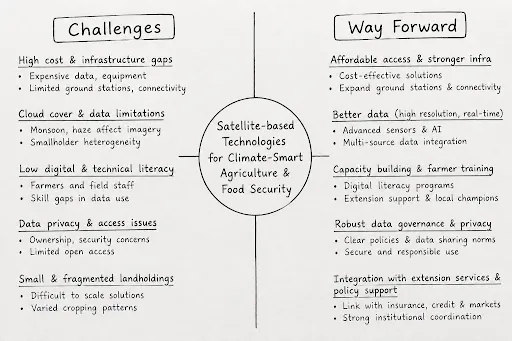
Satellite technology creates an “observe → predict → adapt → produce → distribute” chain: it converts climate and land intelligence into locally appropriate production decisions and converts production intelligence into more stable, affordable and available food supplies.
Latest UPSC Exam 2027 Updates
Last updated on Oct, 2026