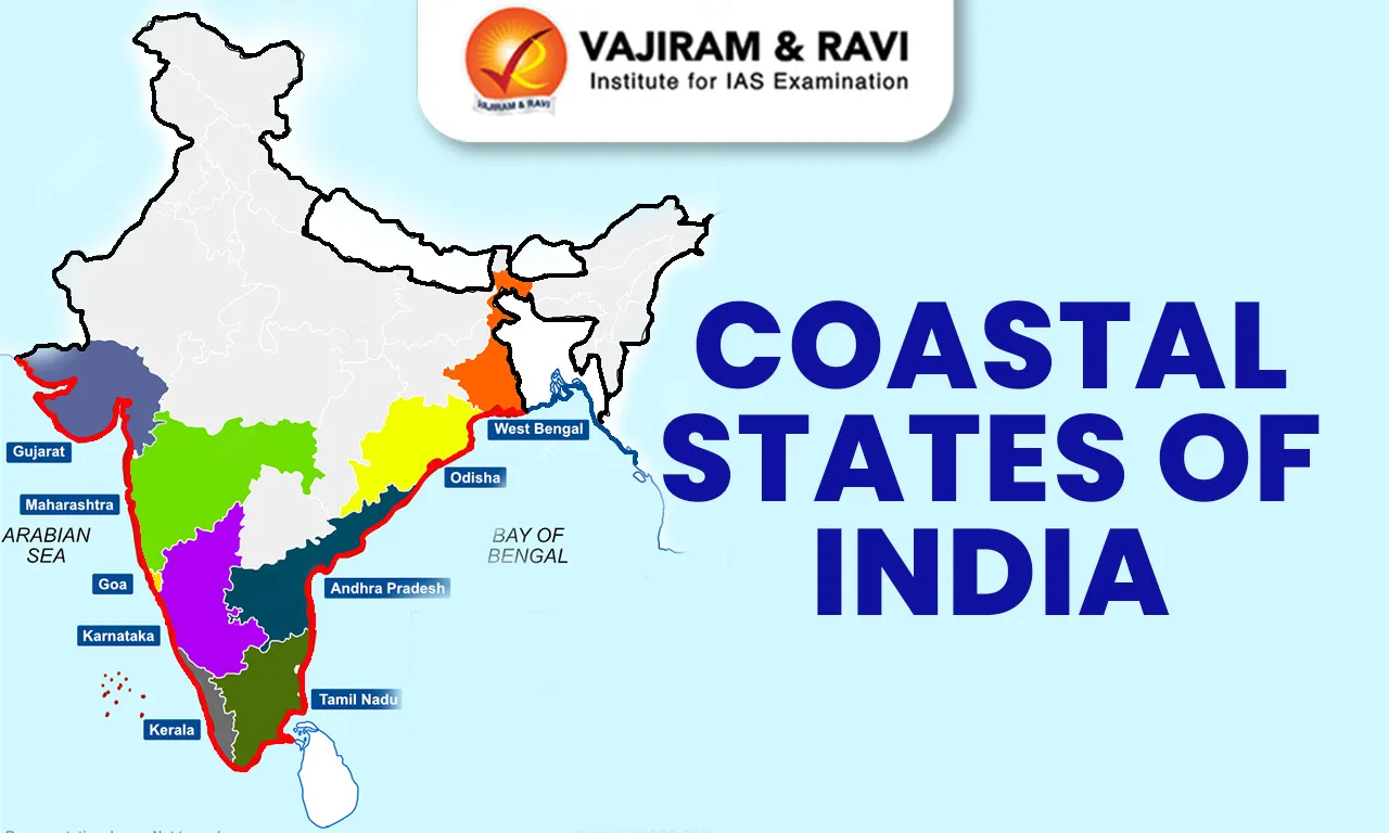
The coastal states of India include Kerala, Tamil Nadu, Gujarat, West Bengal, Goa, Karnataka, Maharashtra, Andhra Pradesh, and Odisha. The coastal union territories are Dadra and Nagar Haveli and Daman and Diu, Puducherry, Lakshadweep Islands, and Andaman & Nicobar Islands.
This coastline spans 9 states and 4 union territories, bordered by the Arabian Sea and Indian Ocean on the west and the Bay of Bengal on the east. Among the coastal states of India, Gujarat has the longest coastline, while Andaman & Nicobar Islands lead among union territories.
Coastal States in India About
The coastal States of India are States that share a boundary with the Arabian Sea, Bay of Bengal, or Indian Ocean. India’s peninsular shape gives it a strategic maritime location in the Indian Ocean Region. India has nine coastal States and four coastal Union Territories, including the island territories of Andaman and Nicobar Islands and Lakshadweep.
Coastal States in India Lengthwise
The revised coastline measurement has changed the state-wise distribution of India’s coastal length. Gujarat has the longest coastline among coastal states of India.
|
Coastal State / Union Territory |
Revised Coastline Length |
|
Gujarat |
2,340.62 km |
|
Tamil Nadu |
1,068.69 km |
|
Andhra Pradesh |
1,053.07 km |
|
Maharashtra |
877.97 km |
|
West Bengal |
721.02 km |
|
Kerala |
600.15 km |
|
Odisha |
574.71 km |
|
Karnataka |
343.30 km |
|
Goa |
193.95 km |
|
Andaman and Nicobar Islands |
3,083.50 km |
|
Lakshadweep |
144.80 km |
|
Puducherry |
42.65 km |
|
Dadra and Nagar Haveli and Daman and Diu |
Part of revised coastal assessment |
|
India Total |
11,098.81 km |


Coastal States in India Features
India's coastline is geographically diverse, featuring extensive coastal plains, sandy beaches, rocky shores, mangrove forests, and fertile deltas nourished by prominent rivers such as the Ganges, Brahmaputra, Godavari, Krishna, and Kaver River System. It serves as a significant ecological zone supporting marine life, ecosystems, and Economic activities like fishing, tourism, and port-based trade.
- Length of Coastline of Indian States: India’s extensive coastline, measuring 11,098.81 km, where India’s 9 coastal states have a combined coastline of about 8,727 km under the revised 2025 measurement. Gujarat has the longest coastline (2,340.62 km), followed by Tamil Nadu and Andhra Pradesh, while Goa has the shortest (193.95 km).
East Coast of India
The Eastern Coast is characterised by plains that are expansive and flat along the Bay of Bengal. Compared to the western coast, the eastern coastal plain is wider and is considered an emergent coast.
- Divisions: The Northern Circar refers to the northern part of this coastline, while the southern section is known as the Coromandel Coast.
- Delta: The eastern rivers, such as the Mahanadi River System, Godavari, Krishna, and Kaveri, create extensive deltas along the coastline.
- Ports: Due to its emergent nature, the eastern coast has fewer ports and harbours in comparison to the western coast.
- Continental shelf: It extends up to 500 kilometres, presenting challenges in the development of major ports and harbours.
- Monazite, mineral-rich in rare earth and thorium, is primarily found in Kerala, Tamil Nadu, Odisha, Andhra Pradesh, Maharashtra, Gujarat, and inland areas of Jharkhand, West Bengal, and Tamil Nadu.
West Coast of India
The Western Coastal Plains stretch from Gujarat in the north to Kerala in the south, passing through Maharashtra, Goa, and Karnataka. These plains are narrower and more rugged than the eastern plains.
- This coastal region is a submerged coastal plain, which influences its geography.
- The width of the plains narrows in the centre and widens towards the northern and southern ends.
- Rivers flowing through this region do not form deltas, unlike other plains.
- Due to submergence, the coast provides ideal natural conditions for developing ports and harbours.
Coastal States of India Map
The map highlights India’s coastal states along the Arabian Sea and Bay of Bengal, showing their geographical distribution from Gujarat in the west to West Bengal in the east.
- Coastal States (west to east): Gujarat → Maharashtra → Goa → Karnataka → Kerala → Tamil Nadu → Andhra Pradesh → Odisha → West Bengal.
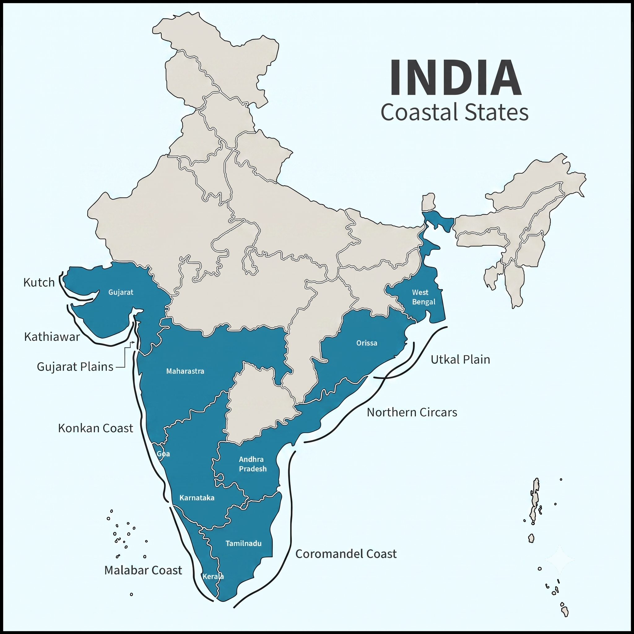
Eastern Coastal States of India
The Eastern Coastal Plains stretch from West Bengal in the north to Tamil Nadu in the south, encompassing Odisha and Andhra Pradesh. These plains are wider and flatter than their western counterparts.
|
West Bengal |
|
|
Odisha |
|
|
Andhra Pradesh |
|
|
Tamil Nadu |
|
Western Coastal States of India
The Western Coastal Plains stretch from Gujarat in the north to Kerala in the south, passing through Maharashtra, Goa, and Karnataka. These plains are narrower and more rugged than the eastern plains. It is roughly divided into Kachchh and Kathiawar Coast, Konkan Coast, and Malabar Coast.
|
Gujarat |
|
|
Maharashtra |
|
|
Goa |
|
|
Karnataka |
|
|
Kerala |
|
The Islands of India
India is home to two major island groups, situated in the Bay of Bengal and the Arabian Sea, which add significant strategic and ecological value to the country. Key island groups:
- Bay of Bengal Islands: This group consists of around 572 islands and islets.
- Arabian Sea Islands: These include the Lakshadweep Islands and Minicoy.
- Classification of islands: India’s islands are broadly divided into Andaman & Nicobar Islands (Bay of Bengal) and Lakshadweep Islands (Arabian Sea).
|
Andaman & Nicobar Islands |
|
|
Lakshadweep Islands |
|
Coastal States of India: Geomorphology
The geomorphology of coastal states of India reflects the interaction of marine erosion, sediment deposition, river processes, tectonics, and sea-level changes. The mainland coast broadly differs into the western and eastern coastal plains, each displaying distinct landforms and evolutionary characteristics.
- Beaches and Sand Bars: Wave action and longshore currents redistribute sediments, producing beaches, bars, barrier bars and spits, particularly along low-gradient coasts.
- Lagoons and Backwaters: Lagoons, tidal creeks and backwaters develop where coastal barriers and sediment deposition partly enclose marine waters; Kerala’s Kayals are a notable example.
- Deltas and Mudflats: Sediment-rich rivers create deltas, mudflats and tidal wetlands, especially along the eastern coast; the Krishna–Godavari and Mahanadi deltaic regions are important examples.
- Changing Coastline Data: India’s officially re-verified coastline is now 11,098.81 km, compared with the earlier 7,516.6 km. The increase primarily reflects better mapping, higher-resolution data and measurement of intricate coastal features and offshore islands, rather than physical addition of land.
Coastal States of India Significance
Coastal states of India are vital for economic growth, ecological security and maritime strategy, making them central to the country’s Blue Economy and Indo-Pacific interests.
- Maritime Trade: Coastal states handle most of India’s overseas trade through major ports such as Mundra in Gujarat, JNPA in Maharashtra and Visakhapatnam in Andhra Pradesh.
- Approximately 95% of India's international trade volume is handled by its ports, and 70% of its value-based trade travels via maritime routes.
- Blue Economy: Coastal communities depend on fisheries, aquaculture, shipping and marine services. Kerala and Tamil Nadu, for instance, have significant fishing and seafood-processing activities.
- Energy Security: Coastal regions support offshore oil and gas exploration and energy infrastructure. The Mumbai High offshore field has historically been a major source of India’s domestic crude oil production.
- Food and Livelihood Security: Marine fisheries provide employment and nutritional support to millions of people. Gujarat’s fishing sector, particularly around Veraval, is an important example of coastal livelihood dependence.
- Strategic Importance: India’s coastline provides access to important Indian Ocean Sea Lines of Communication (SLOCs). Naval facilities such as Kochi and Visakhapatnam strengthen maritime surveillance and defence.
- Tourism: Beaches, islands and backwaters generate significant tourism activity. Goa’s beaches and Kerala’s backwaters illustrate the economic potential of coastal tourism.
Coastal States of India Challenges
Coastal states of India face a combination of environmental, economic, climatic and developmental pressures. Rapid urbanisation and infrastructure growth are increasing pressure on fragile coastal ecosystems.
- Cyclones and Storm Surges: The eastern coast is particularly vulnerable to severe cyclones. Odisha’s Cyclone Fani (2019) demonstrated the risks to coastal settlements, infrastructure and livelihoods.
- Sea-Level Rise: Rising sea levels threaten low-lying coastal areas and islands through inundation, saltwater intrusion and increased flooding. The Sundarbans is particularly vulnerable.
- Marine Pollution: Plastic waste, untreated sewage, industrial effluents and oil pollution degrade marine ecosystems. Chennai’s coastal waters have experienced pollution pressures linked to urbanisation and industrial activity.
- Overfishing: Intensive fishing and destructive practices can reduce fish stocks and affect traditional fishing communities. Kerala’s marine fisheries face pressures from declining stocks and competition over resources.
- Cross-Border Fishermen Disputes: Maritime boundaries and traditional fishing grounds sometimes overlap, leading to arrests, boat seizures and livelihood disruptions.
- The India–Sri Lanka fishermen issue in the Palk Strait is a prominent example, where fishermen from both sides face disputes over fishing grounds and bottom trawling.
Coastal States of India Way Forward
India needs a balanced coastal-development strategy that combines economic use of coastal resources with ecosystem conservation, climate resilience and livelihood security.
- Integrated Coastal Management: Strengthen Integrated Coastal Zone Management (ICZM) to coordinate ports, tourism, fisheries, industries and environmental protection rather than treating them separately.
- Nature-Based Protection: Restore mangroves, coral reefs, dunes and wetlands as natural barriers against cyclones, storm surges and erosion. The Mangrove Initiative for Shoreline Habitats & Tangible Incomes (MISHTI) can support mangrove restoration.
- Climate-Resilient Infrastructure: Make ports, coastal roads, settlements and power infrastructure climate-resilient, particularly in cyclone-prone Odisha, West Bengal and Andhra Pradesh.
- Sustainable Fisheries: Promote responsible fishing, scientific stock assessment and alternative livelihoods while strengthening cold chains and value addition for fishing communities.
- Resolve Fishermen Disputes: Strengthen bilateral mechanisms and joint fisheries-management arrangements with neighbouring countries. The India–Sri Lanka Palk Strait issue requires sustainable fishing practices alongside livelihood protection.
Coastal States of India UPSC PYQs
Q1: Comment on the resource potentials of the long coastlines of India and highlight the status of natural hazard preparedness in these areas. (UPSC Mains 2023)
Q2: Consider the following statements: (UPSC Prelims 2018)
- The Barren Island volcano is an active volcano located in the Indian territory.
- Barren Island lies about 140 km east of Great Nicobar.
- The last time the Barren Island volcano erupted was in 1991, and it has remained inactive since then.
Which of the statements given above is/are correct?
(a) 1 only
(b) 2 and 3
(c) 3 only
(d) 1 and 3
Ans: (a)
Q3: Which one of the following pairs of islands is separated from each other by the 'Ten Degree Channel'? (UPSC Prelims 2014)
(a) Andaman and Nicobar
(b) Nicobar and Sumatra
(c) Maldives and Lakshadweep
(d) Sumatra and Java
Ans: (a)

 Last updated on Oct, 2026
→ UPSC 2027 Notification will be released on 13 January 2027 at upsconline.nic.in.
→ Check Nobel Prize 2026 Winners List here.
→ Download PIB PRiSM Monthly Magazine 2026 here.
→ Check UPSC Monthly Current Affairs Magazine The Recitals here.
→ Check out the latest UPSC Syllabus here.
→ Download UPSC Model Answers for Mains 2026
→ UPSC Mains Question Paper 2026 is out now for Essay & GS Paper 1, 2, 3 & 4.
→ UPSC Calendar 2027 has been released.
→ Enroll in Vajiram & Ravi’s UPSC Mains Test Series 2027 for structured answer writing practice, expert evaluation, and exam-oriented feedback.
→ Join Vajiram & Ravi’s UPSC Mentorship Program 2027 for personalized guidance, strategy planning, and one-to-one support from experienced mentors.
→ Go through the UPSC Mains Previous Year Papers to enhance your preparation.
→ UPSC has released UPSC Toppers List 2025 with the Civil Services final result on its official website.
→ Also check Best UPSC Coaching in India
Coastal States of India FAQs
Q1. How many states are coastal in India?+
Q2. Which are the landlocked states of India?+
Q3. Which is the smallest coastal state in India?+
Q4. Which state has the 3rd longest coastline?+
Q5. Which is the 2nd largest coastline in India?+
Tags: coastal states of india quest UPSC Geography Notes